and estimate travel times to key junction points. Theagency uses this information to manage the corridorand reduce impacts to travel caused by incidentsor weather, with information being updated to thetraveler information map.3.2.2 Implementation and ManagementSensor LocationsThe systems are installed at the end of interchangeon-ramps on both the northbound and southboundside of I-95 and I-295 and controlled via cell modemfrom MaineDOT’s central radio room. There are 75signs installed from Portland to Houlton coveringa distance of approximate 260 miles. The distancebetween the interchanges ranges from 2 miles to .10 miles apart. The VSL signs allow the Departmentto measure average Interstate segment speeds, whichcan be used to detect delays and allow motoriststo estimate travel durations to key junction points.MaineDOT is also using Bluetooth technology throughTrafficCast to monitor real-time travel data forseveral other routes.System Architecture and ProcessesThe VSL system is not part of an integrated system,but it uses a tiered approach that involves the radar,camera, and dispatcher information to verify incidentson the corridor and reinforce decisions for the route.Analysis of the data is automated, but it involves directreview, analysis, and decision making by MaineDOTdispatchers. MaineDOT built this into their processto give a sense of ownership to the dispatchers. Thedispatchers have three main roles: 1) monitor the twowayradio communications; 2) address public inquiries;and 3) maintain the data entry of the informationposted on the 511 website and traveler informationmap. The dispatchers oversee the communications tothe signs. This is accomplished through the use of acellular modem, which is sampled every 15 minutes.Speed and occupancy data are sent to a server andprocessed through an algorithm analysis. A thresholdspeed of 40 mph initiates an alert that is emailed toa dispatcher. The dispatcher reviews the data, whichare displayed in a spreadsheet. Based on the datapresented, the dispatcher will program the VSL sign(s)to reflect an appropriate speed for the current roadconditions. If available, the dispatcher will use a camerafeed to verify the roadway condition, and issue asituational alert for public and operations posting.3.2.3 Future ConsiderationsMobile ApplicationsMaineDOT is considering evaluating mobile applicationsused by smartphones to collect traveler informationthat the user agrees to send. One example of a socialapplication is Waze, a community-based traffic andnavigation application for real-time traffic and roadinformation. The data from the Waze applicationmay be used in the future to build value on topof data currently available to MaineDOT and cansupplement information being collected by theagency. This information may eventually help toexplicitly communicate travel times to motorists whoare without access to mobile devices. To considerintegrating mobile applications into the trafficmanagement process, MaineDOT is working on arequest for information (RFI) to solicit other applicationvendors to come forward and be evaluated.CostsCosts for this basic but informative way to sharetravel information are much less than deploymentof DMS and associated hardware, software, andtechnology packages. The total MaineDOT VSLproject cost was $776,849.54. The replacementcost for a VSL sign is estimated at approximately$10,000. To add a radar unit to each sign costsapproximately $500 and each camera costsapproximately $1,500. The combined cost forcameras and radar units was approximately $66,000.In comparison, deploying this type of system costsapproximately one-tenth of traditional travel timecommunication devices such as DMS.3.3 Various Statewide Routes,WisconsinWisconsin DOT (WisDOT) has implemented traveltime data collection systems on rural roads as partof its Traffic <strong>Operations</strong> Implementation Plan (TOIP),which guides efforts in transportation planning andimprovement and allows ITS to be implemented inmajor roadway projects at a cost that is consideredincidental to the project (i.e., less than 10 percent ofproject cost). The TOIP encourages ITS deploymentto be considered in the construction process tomitigate construction-related congestion; it also<strong>Rural</strong> <strong>Data</strong> <strong>Collection</strong> <strong>Technology</strong>Federal Highway Administration28
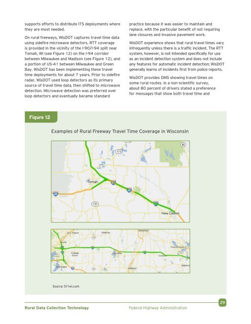
supports efforts to distribute ITS deployments wherethey are most needed.On rural freeways, WisDOT captures travel time datausing sidefire microwave detectors. RTT coverageis provided in the vicinity of the I-90/I-94 split nearTomah, WI (see Figure 12) on the I-94 corridorbetween Milwaukee and Madison (see Figure 12), anda portion of US-41 between Milwaukee and GreenBay. WisDOT has been implementing these traveltime deployments for about 7 years. Prior to sidefireradar, WisDOT used loop detectors as its primarysource of travel time data, then shifted to microwavedetection. Microwave detection was preferred overloop detectors and eventually became standardpractice because it was easier to maintain andreplace, with the particular benefit of not requiringlane closures and invasive pavement work.WisDOT experience shows that rural travel times varyinfrequently unless there is a traffic incident. The RTTsystem, however, is not intended specifically for useas an incident detection system and does not includeany features for automatic incident detection; WisDOTgenerally learns of incidents first from police reports.WisDOT provides DMS showing travel times onsome rural routes. In a non-scientific survey,about 80 percent of drivers stated a preferencefor messages that show both travel time andFigure 12Examples of <strong>Rural</strong> Freeway Travel Time Coverage in WisconsinSource: 511wi.com<strong>Rural</strong> <strong>Data</strong> <strong>Collection</strong> <strong>Technology</strong>Federal Highway Administration29