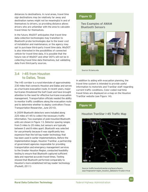
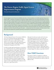
distances to destinations. In rural areas, travel timesign destinations may be relatively far away anddestination names might not be meaningful in and ofthemselves to drivers, so providing distance allowsdrivers who are unfamiliar with the area to calculatetravel times for themselves.Figure 13Two Examples of AWAMBluetooth SensorsIn the future, WisDOT anticipates that travel timedata collection technologies may transition toBluetooth probe technologies due to the lower costof installation and maintenance, or the agency mayopt to purchase third-party travel time data. WisDOTis also interested in the possibilities of connectedvehicle for travel time data. It is possible that thefuture role of WisDOT and other DOTs will not be incollecting travel time data themselves, but validatingdata from third-party sources.3.4 I-45 from Houstonto Dallas, TexasThe I-45 corridor is a rural Interstate of approximately230 miles that connects Houston and Dallas and servesas a hurricane evacuation route. In recent years, majorhurricanes threatened the Gulf Coast and have broughtattention to the need for effective hurricane evacuationmanagement. Transportation officials needed the abilityto monitor traffic conditions along the evacuation routeand to determine whether to deploy contraflow (TexasTransportation Researcher, June 2010).In 2009 Bluetooth detectors were installed along225 miles of I-45 to collect the necessary trafficinformation. Two examples of pole-mounted Bluetoothunits are shown in Figure 13. Detector spacing rangesfrom 5 miles to 20 miles, but sensors are typicallybetween 5 and 8 miles apart. Bluetooth was selectedfor use primarily because it was significantly lessexpensive than the toll tag reader technology thathas been used in earlier implementations. Before theimplementation began, Houston TranStar, a partnershipof government agencies responsible for providingtransportation and emergency management servicesto the Greater Houston Region, conducted feasibilitytesting to ensure that Bluetooth captured sufficientdata and reported accurate travel times. Testingshowed that Bluetooth performed comparably toHouston’s more established toll tag reader technology(Puckett, 2011)Source: tti.tamu.eduIn addition to aiding with evacuation planning, thetravel time system is intended to provide usefulinformation to motorists and TranStar staff regardingcurrent traffic conditions. Color coded real-timetravel times are displayed on a map on the HoustonTranStar website (see Figure 14).Figure 14Houston TranStar I-45 Traffic MapSource: traffic.houstontranstar.org/layers/layers.aspx?mapname=region_houston_dallas&inc=true&rc=true<strong>Rural</strong> <strong>Data</strong> <strong>Collection</strong> <strong>Technology</strong>Federal Highway Administration30
3.5 Various Routes in Oregon,Frontier Travel Time ProjectIn 2000, the Frontier Project Technical AdvisoryCommittee (TAC), which includes representativesfrom eight State DOTs, selected an RTT estimationsystem for demonstration on rural highways near theOregon coast (Wright, Shi, & Lee, 2005). Congestionand incidents are common on this corridor, andthe TAC intended for the demonstration project tobe capable of providing travel times and incidentinformation to Oregon DOT (ODOT) and to motorists.The TAC distributed system requirements tointerested vendors and vetted bids based on price,previous success with travel time deployments,and timeliness. The TAC chose an infrared ALPRtechnology. The system read license plates,encrypted the license plate numbers, and sent themvia telephone communications to a central server,where vehicle matches were made and travel timeswere calculated. The entire travel time systemconsisted of a total of six license plate recognitioncameras mounted on cantilevers above the road.Each installation consists of two cameras, one foreach direction. One road segment was 3.15 mileslong and the other road segment was 22.25 mileslong. The TAC cooperated closely with the vendor toensure that the system was installed as specified.The system operated as intended for the first .2 months in 2001, but then a series of software andequipment failures ended the initial effort, and thesystem remained dysfunctional until 2004. The mostsignificant problem was a faulty power supply module,which was not replaced by the vendor for almost1 year. Once the replacement part was available, ittook another year for ODOT staff to fully repair thesystem because there was a significant backlog ofmaintenance work elsewhere, and the travel timesystem was considered non-critical to safe operationof the roadway network.Upon restoration of the system, the quality of thesystem’s data was evaluated. Analyses showed thatwhen the system was functional, it provided accuratetravel times, though an insufficient amount of datawere available under congested conditions to evaluatesystem accuracy when traffic is heavy. Segmentlength had a significant effect on vehicle match rates:for the long 22-mile segment, match rates wereunder 5 percent of traffic, whereas for the short3-mile segment, match rates were above 15 percent.The system also could be used for incident detection,but ODOT found that cell phone calls from motoristsand other communication means were generallyfaster and more reliable. Despite this success, thesystem was discontinued due to ongoing operationaland maintenance issues; ODOT was not willing to relyon the data or disseminate it given that the systemwas prone to failure.Lessons learned in this demonstration .project include:• Maintenance of ITS devices is particularlyburdensome to rural transportation districts,which may have less staff covering a wider areathan urban districts and fewer maintenance funds• Travel time systems must be operationallyreliable to be used effectively• Sufficient staff, equipment, and funding shouldbe available for system maintenance• There are risks in deploying a first-of-its-kindproject• Segment length and congested conditions have .an effect on data reliability3.6 State Route 520in Orange County, FLThe Orlando-Orange County Expressway Authority(OOCEA) manages one DMS, located in the eastern partof Orange County, between Orlando and the Atlanticcoast. The sign was installed in 2008 on northboundSR-520, about 0.5 miles before reaching SR-528. Thissign is in a largely undeveloped, rural area.This DMS was originally intended to assist with coastalevacuations: in such scenarios, the SR-520 northboundto SR-528 westbound route would be heavily utilized(see Figure 15). However, at this junction driversheaded toward Orlando have the choice of eitherremaining on SR-520 or switching to SR-528; bothroutes are viable options to reach much of the Orlandoarea. To aid drivers, travel times for westbound SR-528are shown on this DMS. SR-528 is a toll road that isheavily used by commuters to Orlando and travelersheaded to or from Orlando International Airport.Although travel times are not shown for SR-520, .drivers can use the SR-528 travel time to helpdetermine which route would be best for them. For<strong>Rural</strong> <strong>Data</strong> <strong>Collection</strong> <strong>Technology</strong>Federal Highway Administration31