Rural Data Collection Technology - FHWA Operations - U.S. ...
Rural Data Collection Technology - FHWA Operations - U.S. ...
Rural Data Collection Technology - FHWA Operations - U.S. ...
- No tags were found...

You also want an ePaper? Increase the reach of your titles
YUMPU automatically turns print PDFs into web optimized ePapers that Google loves.
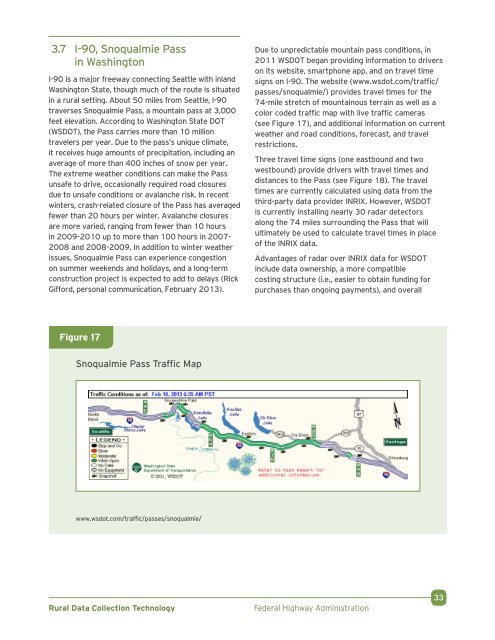
3.7 I-90, Snoqualmie Passin WashingtonI-90 is a major freeway connecting Seattle with inland .Washington State, though much of the route is situatedin a rural setting. About 50 miles from Seattle, I-90traverses Snoqualmie Pass, a mountain pass at 3,000feet elevation. According to Washington State DOT(WSDOT), the Pass carries more than 10 milliontravelers per year. Due to the pass’s unique climate,it receives huge amounts of precipitation, including anaverage of more than 400 inches of snow per year. .The extreme weather conditions can make the Passunsafe to drive, occasionally required road closuresdue to unsafe conditions or avalanche risk. In recentwinters, crash-related closure of the Pass has averagedfewer than 20 hours per winter. Avalanche closuresare more varied, ranging from fewer than 10 hoursin 2009-2010 up to more than 100 hours in 2007-2008 and 2008-2009. In addition to winter weatherissues, Snoqualmie Pass can experience congestionon summer weekends and holidays, and a long-termconstruction project is expected to add to delays (RickGifford, personal communication, February 2013).Due to unpredictable mountain pass conditions, in2011 WSDOT began providing information to driverson its website, smartphone app, and on travel timesigns on I-90. The website (www.wsdot.com/traffic/passes/snoqualmie/) provides travel times for the74-mile stretch of mountainous terrain as well as acolor coded traffic map with live traffic cameras .(see Figure 17), and additional information on currentweather and road conditions, forecast, and travelrestrictions.Three travel time signs (one eastbound and twowestbound) provide drivers with travel times anddistances to the Pass (see Figure 18). The traveltimes are currently calculated using data from thethird-party data provider INRIX. However, WSDOTis currently installing nearly 30 radar detectorsalong the 74 miles surrounding the Pass that willultimately be used to calculate travel times in placeof the INRIX data.Advantages of radar over INRIX data for WSDOTinclude data ownership, a more compatiblecosting structure (i.e., easier to obtain funding forpurchases than ongoing payments), and overallFigure 17Snoqualmie Pass Traffic Mapwww.wsdot.com/traffic/passes/snoqualmie/<strong>Rural</strong> <strong>Data</strong> <strong>Collection</strong> <strong>Technology</strong>Federal Highway Administration33