Contaminant pathways in Port Curtis: Final report - OzCoasts
Contaminant pathways in Port Curtis: Final report - OzCoasts
Contaminant pathways in Port Curtis: Final report - OzCoasts

You also want an ePaper? Increase the reach of your titles
YUMPU automatically turns print PDFs into web optimized ePapers that Google loves.
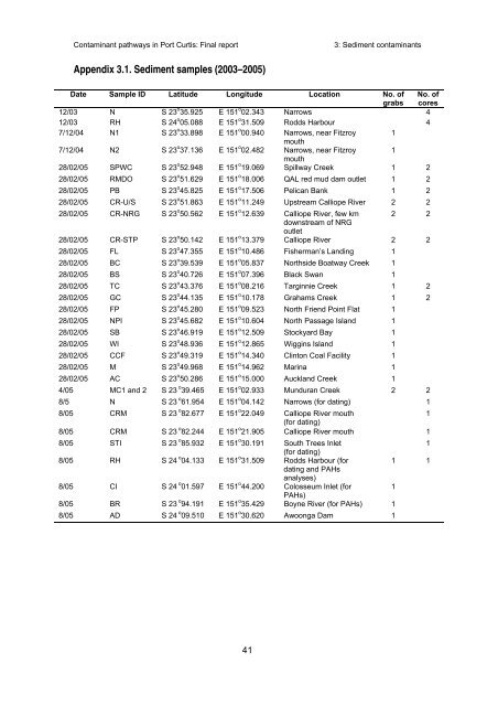
<strong>Contam<strong>in</strong>ant</strong> <strong>pathways</strong> <strong>in</strong> <strong>Port</strong> <strong>Curtis</strong>: F<strong>in</strong>al <strong>report</strong>3: Sediment contam<strong>in</strong>antsAppendix 3.1. Sediment samples (2003–2005)Date Sample ID Latitude Longitude Location No. ofgrabsNo. ofcores12/03 N S 23 o 35.925 E 151 o 02.343 Narrows 412/03 RH S 24 o 05.088 E 151 o 31.509 Rodds Harbour 47/12/04 N1 S 23 o 33.898 E 151 o 00.940 Narrows, near Fitzroy 1mouth7/12/04 N2 S 23 o 37.136 E 151 o 02.482 Narrows, near Fitzroy 1mouth28/02/05 SPWC S 23 o 52.948 E 151 o 19.069 Spillway Creek 1 228/02/05 RMDO S 23 o 51.629 E 151 o 18.006 QAL red mud dam outlet 1 228/02/05 PB S 23 o 45.825 E 151 o 17.506 Pelican Bank 1 228/02/05 CR-U/S S 23 o 51.863 E 151 o 11.249 Upstream Calliope River 2 228/02/05 CR-NRG S 23 o 50.562 E 151 o 12.639 Calliope River, few km 2 2downstream of NRGoutlet28/02/05 CR-STP S 23 o 50.142 E 151 o 13.379 Calliope River 2 228/02/05 FL S 23 o 47.355 E 151 o 10.486 Fisherman’s Land<strong>in</strong>g 128/02/05 BC S 23 o 39.539 E 151 o 05.837 Northside Boatway Creek 128/02/05 BS S 23 o 40.726 E 151 o 07.396 Black Swan 128/02/05 TC S 23 o 43.376 E 151 o 08.216 Targ<strong>in</strong>nie Creek 1 228/02/05 GC S 23 o 44.135 E 151 o 10.178 Grahams Creek 1 228/02/05 FP S 23 o 45.280 E 151 o 09.523 North Friend Po<strong>in</strong>t Flat 128/02/05 NPI S 23 o 45.682 E 151 o 10.604 North Passage Island 128/02/05 SB S 23 o 46.919 E 151 o 12.509 Stockyard Bay 128/02/05 WI S 23 o 48.936 E 151 o 12.865 Wigg<strong>in</strong>s Island 128/02/05 CCF S 23 o 49.319 E 151 o 14.340 Cl<strong>in</strong>ton Coal Facility 128/02/05 M S 23 o 49.968 E 151 o 14.962 Mar<strong>in</strong>a 128/02/05 AC S 23 o 50.286 E 151 o 15.000 Auckland Creek 14/05 MC1 and 2 S 23 o 39.465 E 151 o 02.933 Munduran Creek 2 28/5 N S 23 o 61.954 E 151 o 04.142 Narrows (for dat<strong>in</strong>g) 18/05 CRM S 23 o 82.677 E 151 o 22.049 Calliope River mouth1(for dat<strong>in</strong>g)8/05 CRM S 23 o 82.244 E 151 o 21.905 Calliope River mouth 18/05 STI S 23 o 85.932 E 151 o 30.191 South Trees Inlet1(for dat<strong>in</strong>g)8/05 RH S 24 o 04.133 E 151 o 31.509 Rodds Harbour (for1 1dat<strong>in</strong>g and PAHsanalyses)8/05 CI S 24 o 01.597 E 151 o 44.200 Colosseum Inlet (for1PAHs)8/05 BR S 23 o 94.191 E 151 o 35.429 Boyne River (for PAHs) 18/05 AD S 24 o 09.510 E 151 o 30.620 Awoonga Dam 141