The Rights of Way Improvement Plan for RCT - Rhondda Cynon Taf
The Rights of Way Improvement Plan for RCT - Rhondda Cynon Taf
The Rights of Way Improvement Plan for RCT - Rhondda Cynon Taf
- No tags were found...

You also want an ePaper? Increase the reach of your titles
YUMPU automatically turns print PDFs into web optimized ePapers that Google loves.
O ut &AboutTHE RIGHTS OF WAY IMPROVEMENT PLANFOR RHONDDA CYNON TAFCOUNTRYSIDE
ContentsExecutive Summary ..................................................................................................11. Background and contextIntroduction ......................................................................................................3Legislative Background ......................................................................................3Area Description................................................................................................3<strong>The</strong> Assessment..................................................................................................4Map One: <strong>Rhondda</strong> <strong>Cynon</strong> <strong>Taf</strong> CBC area ..........................................................52. PolicyPolicy Context and the Importance <strong>of</strong> Policy......................................................6Community <strong>Plan</strong> ‘A Better Life’ ..........................................................................6Area Partnership and Communities First Action <strong>Plan</strong>s ......................................7Local Development <strong>Plan</strong>....................................................................................7Sustainable Development ..................................................................................7Regional Transport <strong>Plan</strong> ....................................................................................7Countryside Strategy / Living Space Action Programme3. Different Users and their NeedsWalking ............................................................................................................8Horse Riding......................................................................................................8Cycling ..............................................................................................................8Access <strong>for</strong> All ....................................................................................................8Carriage Driving ................................................................................................9Motorised Vehicles ............................................................................................9General Findings................................................................................................9Non-Users ........................................................................................................94. Use, Demand and Reasons <strong>for</strong> AccessPopulation ......................................................................................................10Socio-Economic Pr<strong>of</strong>ile....................................................................................10Map Two: Population density ..........................................................................11Map Three: Persons per km <strong>of</strong> <strong>Rights</strong> <strong>of</strong> <strong>Way</strong> Ward Map ..................................12Map Four: Persons per Hectare <strong>of</strong> Open Access Ward Map ............................13Map Five: Welsh Index <strong>of</strong> Multiple Deprivation ..............................................14Map Six: Welsh Index <strong>of</strong> Health Deprivation ..................................................15Healthy Living ................................................................................................16Recreation, Leisure and Tourism ......................................................................16Commuting and Utility Use ............................................................................16Latent Demand ................................................................................................17Conflicting Interests ........................................................................................17Out & About: <strong>The</strong> <strong>Rights</strong> <strong>of</strong> <strong>Way</strong> <strong>Improvement</strong> <strong>Plan</strong> <strong>for</strong> <strong>Rhondda</strong> <strong>Cynon</strong> <strong>Taf</strong>
5. Current Provision<strong>The</strong> Public <strong>Rights</strong> <strong>of</strong> <strong>Way</strong> Network ....................................................................18<strong>The</strong> State <strong>of</strong> the Network..........................................................................18Legally defined ........................................................................................18Management............................................................................................18Publicity ..................................................................................................19Claimed Right <strong>of</strong> <strong>Way</strong>s ............................................................................19Open Access Land ............................................................................................19Forestry Commission <strong>of</strong> Wales Land ..................................................................19Council-owned Land, including Key Countryside Sites, ....................................20Local Nature Reserves, Country Parks and Public Parks......................................20Permissive Paths ................................................................................................20Highway Network..............................................................................................20Map Seven: <strong>The</strong> Access Network ......................................................................216. Assessment and Evaluation<strong>The</strong> Vision..........................................................................................................22Objective One: Promote outdoor countryside activity <strong>for</strong> health, ....................22regeneration, tourism and recreationObjective Two: Promote walking and cycling as transport options ..................23Objective Three: Protect the access resource (including PROW, ........................23highways, access land and Council facilities)Objective Four: Improve provision <strong>for</strong> walkers, cyclists, horse riders, ..............24<strong>of</strong>f road vehicles and users with disabilitiesObjective Five: Involve local community and voluntary organisations in ........ 25the development, promotion and use <strong>of</strong> access opportunitiesObjective Six: Develop a more efficient <strong>of</strong>fice management system.............. 25<strong>for</strong> statutory <strong>Rights</strong> <strong>of</strong> <strong>Way</strong> work including the Definitive Map7. ActionsStatement <strong>of</strong> Action ..........................................................................................26Objective One: Promote outdoor countryside activity <strong>for</strong> health, ....................28regeneration, tourism and recreationObjective Two: Promote walking and cycling as transport options ..................30Objective Three: Protect the access resource (including PROW, highways ........32access land and Council facilities)Objective Four: Improve provision <strong>for</strong> walkers, cyclists, horse riders, ..............34<strong>of</strong>f road vehicles and users with disabilitiesObjective Five: Involve local community and voluntary organisations in ........36the development, promotion and use <strong>of</strong> access opportunitiesObjective Six: Develop a more efficient <strong>of</strong>fice management system <strong>for</strong>..........38statutory <strong>Rights</strong> <strong>of</strong> <strong>Way</strong> work Including the Definitive Map8. Implementation ..................................................................................................409. Monitoring and reporting ..................................................................................42AppendicesAppendix One: Population ..............................................................................43Appendix Two: Summary <strong>of</strong> assessment findings relating to each objective ....44Appendix Three: Council funding 2007-8 ..........................................................46Appendix Four: Duties and Powers <strong>of</strong> Local Authorities ..................................47Appendix Five: Abbreviations and Glossary ....................................................50Out & About: <strong>The</strong> <strong>Rights</strong> <strong>of</strong> <strong>Way</strong> <strong>Improvement</strong> <strong>Plan</strong> <strong>for</strong> <strong>Rhondda</strong> <strong>Cynon</strong> <strong>Taf</strong>
VISION STATEMENT FORCOUNTRYSIDE ACCESS INRHONDDA CYNON TAF“To manage, develop and promote thenetwork <strong>of</strong> local public rights <strong>of</strong> way andother countryside access in order to satisfy presentand likely future demand <strong>for</strong> the enjoyment <strong>of</strong> thecountryside, open-air recreation, exercise”and ‘access <strong>for</strong> all’.Out & About: <strong>The</strong> <strong>Rights</strong> <strong>of</strong> <strong>Way</strong> <strong>Improvement</strong> <strong>Plan</strong> <strong>for</strong> <strong>Rhondda</strong> <strong>Cynon</strong> <strong>Taf</strong>
Executive Summary<strong>The</strong> <strong>Rights</strong> <strong>of</strong> <strong>Way</strong> <strong>Improvement</strong> <strong>Plan</strong>is published following a lengthyconsultation process that included anIssues Paper (2005), Assessment (2006)and the draft <strong>Plan</strong> (Jan 2007). <strong>The</strong>response to consultation at each stagehas also been published. <strong>The</strong>amended Assessment <strong>for</strong>ms part <strong>of</strong> thefinal plan and is available on request.<strong>The</strong> publication <strong>of</strong> the <strong>Plan</strong> meets theduty set out in <strong>The</strong> Countryside and<strong>Rights</strong> <strong>of</strong> <strong>Way</strong> Act 2000.<strong>The</strong> Introduction describes thelegislative background and thelandscape <strong>of</strong> <strong>Rhondda</strong> <strong>Cynon</strong> <strong>Taf</strong>. Itsummarises the access opportunitiesidentified in the Assessment.Chapter two summarises the policycontext as relevant to Out & About,drawing on the Issues Paper, theAssessment and consultationresponses.Chapter three describes the differentusers <strong>of</strong> the access network and theirneeds. It highlights the deficiencies asidentified in the Issues Paper, theAssessment and the responses toconsultation.Chapter four focuses on the use,demand and reasons <strong>for</strong> access.Healthy living, recreation and utilityuse are considered, as well as latentdemand and conflicting interests.Chapter five examines the currentaccess provision. <strong>The</strong> <strong>Rights</strong> <strong>of</strong> <strong>Way</strong>network is described, the new OpenAccess provisions are explained,together with permissive paths, KeyCountryside Sites and Parks. <strong>The</strong> role<strong>of</strong> the highway network is alsoaddressed.Chapter six presents the objectives <strong>for</strong>the <strong>Rights</strong> <strong>of</strong> <strong>Way</strong> <strong>Improvement</strong> <strong>Plan</strong>.Each objective is discussed in relationto the assessment findings and thepolicy that underpins the objective.Objective 1:Promote outdoor countryside activity<strong>for</strong> health, regeneration, tourism andrecreationObjective 2:Promote walking and cycling astransport optionsObjective 3Protect the access resource (includingPROW, highways, access land andCouncil facilities)Objective 4:Improve provision <strong>for</strong> walkers, cyclists,horse riders, <strong>of</strong>f road vehicles andusers with disabilitiesObjective 5:Involve local community andvoluntary organisations in thedevelopment, promotion and use <strong>of</strong>access opportunitiesObjective 6:Develop a more efficient <strong>of</strong>ficemanagement system <strong>for</strong> statutory<strong>Rights</strong> <strong>of</strong> <strong>Way</strong> work including theDefinitive MapOut & About: <strong>The</strong> <strong>Rights</strong> <strong>of</strong> <strong>Way</strong> <strong>Improvement</strong> <strong>Plan</strong> <strong>for</strong> <strong>Rhondda</strong> <strong>Cynon</strong> <strong>Taf</strong>1
Executive SummaryChapter seven sets out the Statement<strong>of</strong> Action. For each objective, a series<strong>of</strong> actions are proposed. <strong>The</strong>se arecategorised as ‘service’ actions orprojects. <strong>The</strong> service actions aresubdivided into strategic and routine.<strong>The</strong> projects are divided into existingand new projects. Tables associatedwith each objective indicate theresource requirements (existing andnew), timescale and the partnersinvolved in the implementation <strong>of</strong>each action.Chapter eight summaries the issuesrelating to the implementation <strong>of</strong> theaction plan.Chapter nine sets out the proposals <strong>for</strong>monitoring, evaluation and review <strong>of</strong>the <strong>Plan</strong>.<strong>The</strong> Appendices provide backgroundand supporting in<strong>for</strong>mation.<strong>The</strong> <strong>Rights</strong> <strong>of</strong> <strong>Way</strong> <strong>Improvement</strong> <strong>Plan</strong>should be read in conjunction with theIssues Paper (2005) and theAssessment (2006).2Out & About: <strong>The</strong> <strong>Rights</strong> <strong>of</strong> <strong>Way</strong> <strong>Improvement</strong> <strong>Plan</strong> <strong>for</strong> <strong>Rhondda</strong> <strong>Cynon</strong> <strong>Taf</strong>
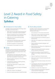
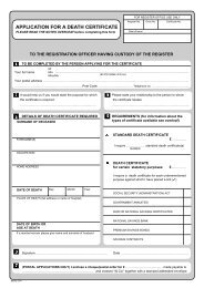
1. Background and contextIntroduction<strong>The</strong> Out & About <strong>Plan</strong> is the final stagein the <strong>Rights</strong> <strong>of</strong> <strong>Way</strong> <strong>Improvement</strong> <strong>Plan</strong>process. <strong>The</strong> procedure and content isset out in Guidance from the WelshAssembly. In spring 2005, an IssuesPaper was published <strong>for</strong> consultationgiving an outline <strong>of</strong> the stages <strong>of</strong> the<strong>Plan</strong> preparation and the key issuesrelevant <strong>for</strong> the <strong>Plan</strong>. This in<strong>for</strong>med theAssessment, published in January2006, which considered the accessnetwork and access needs within theCounty Borough. <strong>The</strong> Draft <strong>Plan</strong> waspublished in January 2007, theconsultation closed in April and thereport <strong>of</strong> the final consultation hasbeen published. Amendments havebeen made as a result <strong>of</strong> theconsultation.Legislative backgroundUnder Section 60 <strong>of</strong> the Countrysideand <strong>Rights</strong> <strong>of</strong> <strong>Way</strong> Act, each localHighway Authority is required toassess the rights <strong>of</strong> way network andaccess land within the CountyBorough, and produce a <strong>Rights</strong> <strong>of</strong> <strong>Way</strong><strong>Improvement</strong> <strong>Plan</strong>. For ‘Out & About:the <strong>Rights</strong> <strong>of</strong> <strong>Way</strong> <strong>Improvement</strong> <strong>Plan</strong><strong>for</strong> <strong>Rhondda</strong> <strong>Cynon</strong> <strong>Taf</strong>’ rights <strong>of</strong> way,open access land, dedicated accessland (Forestry Commission land), KeyCountryside Sites, parks and otherpermissive access land have beenincluded.<strong>The</strong> Welsh Assembly Governmentguidance states that the <strong>Rights</strong> <strong>of</strong> <strong>Way</strong><strong>Improvement</strong> <strong>Plan</strong> should assess:area, and the accessibility <strong>of</strong> rights<strong>of</strong> way to blind or partially sightedpersons, and others with mobilityproblems, and• a statement <strong>of</strong> the actions that theLocal Authority will take to improvethe network <strong>of</strong> rights <strong>of</strong> way.<strong>The</strong> guidance sets out the roles <strong>of</strong> the<strong>Rights</strong> <strong>of</strong> <strong>Way</strong> <strong>Improvement</strong> <strong>Plan</strong> as astrategic plan, a bidding document <strong>for</strong>resources and the basis <strong>for</strong> developingwork programmes.Area Description<strong>Rhondda</strong> <strong>Cynon</strong> <strong>Taf</strong> County Boroughextends from the uplands <strong>of</strong> theBrecon Beacons, to the rolling hills <strong>of</strong>the Vale <strong>of</strong> Glamorgan. Out & Aboutdoes not cover the area included inthe Brecon Beacons National Park, asthe National Park Authority ispreparing its own <strong>Rights</strong> <strong>of</strong> <strong>Way</strong><strong>Improvement</strong> <strong>Plan</strong>. See Map 1.<strong>The</strong> countryside is extensive, coveringabout 80% <strong>of</strong> the County Borough. Inthe north, steep-sided valleys cut thespectacular scenery <strong>of</strong> the moorlandand <strong>for</strong>estry plateau. <strong>The</strong> slopes <strong>of</strong>ffridd with crags, scree, woodland, wetflushes, heath and grassy slopes <strong>for</strong>mthe backdrop to the valley towns.South <strong>of</strong> Pontypridd, the valleys arewider and the plateau lower. <strong>The</strong>scenery is more characteristic <strong>of</strong> theborders <strong>of</strong> the Vale <strong>of</strong> Glamorgan, withrolling hills and a lowland landscape<strong>of</strong> enclosed farmland and woods.<strong>The</strong>re is also more built development,with housing estates and businessestaking advantage <strong>of</strong> the M4 corridor.• the extent to which local rights <strong>of</strong>way meet the present and likelyfuture needs <strong>of</strong> the public.Throughout the County Borough thereare diverse access opportunities. <strong>The</strong>• the opportunities provided by localopen moors can <strong>of</strong>fer remote andrights <strong>of</strong> way (and in particular bychallenging walking, thick <strong>for</strong>estryfootpaths, cycle tracks, bridlewaysplantations contrast with the dappledand restricted byways), <strong>for</strong> exercisesun-lit deciduous woodlands. You canand other <strong>for</strong>ms <strong>of</strong> open airchoose a steep scramble by arecreation, the enjoyment <strong>of</strong> themountain stream or a level, surfaced3Out & About: <strong>The</strong> <strong>Rights</strong> <strong>of</strong> <strong>Way</strong> <strong>Improvement</strong> <strong>Plan</strong> <strong>for</strong> <strong>Rhondda</strong> <strong>Cynon</strong> <strong>Taf</strong>
<strong>for</strong>mer railway track by the river. In thenorth <strong>of</strong> the County Borough openaccess land is extensive, in placesadjoining the terraced streets. In thesouth, the footpath and bridlewaynetwork is denser, crossing acountryside <strong>of</strong> farms and small woods.<strong>The</strong> Assessment<strong>The</strong> Assessment quantified the extent<strong>of</strong> the countryside access networkavailable <strong>for</strong> public recreation andenjoyment. Details were presented <strong>for</strong>the County Borough as a whole and<strong>for</strong> each ward. Almost 25% <strong>of</strong> theCounty Borough is designated asaccess land (outside the BreconBeacons National Park), most <strong>of</strong> thisbeing in the north <strong>of</strong> the borough. <strong>The</strong>south has a greater concentration <strong>of</strong>the extensive 743 km public rights <strong>of</strong>way network. Most people have accessopportunities close to where they liveand work.<strong>The</strong> Assessment also considered theneeds <strong>of</strong> users and <strong>of</strong> specific groups.This drew on the results <strong>of</strong>consultation with interestedorganisations and the general publicthrough the Issues Paper and a publicquestionnaire. Further in<strong>for</strong>mation wasobtained through examination <strong>of</strong>existing internal and external strategicpolicy and consultation with a range <strong>of</strong>partnership bodies, which haveundertaken their own consultationexercises. <strong>The</strong> improvement <strong>of</strong> theaccess network has clear links, <strong>for</strong>example, with the Council’sCommunity <strong>Plan</strong> and the emergingaction plans <strong>of</strong> the five thematicpartnerships as well as the AreaRegeneration Partnerships.To build a detailed picture <strong>of</strong> accessprovision, a ward-by-ward assessment<strong>of</strong> the access network has beenconducted. This includes Open Accessland, Forestry Commission land, KeyCountryside Sites, parks, permissivepaths and footpaths, bridleways,byways as recorded on the DefinitiveMap. <strong>The</strong> results are presented insummary tables, graphs and maps <strong>for</strong>the County Borough as a whole, withthe ward descriptions, maps and fulldata presented in appendices. <strong>The</strong>tables showed the length <strong>of</strong> path andthe area <strong>of</strong> open access in relation tothe population and area <strong>of</strong> the ward.<strong>The</strong> results <strong>of</strong> the Assessment havein<strong>for</strong>med the preparation <strong>of</strong> the Draftand the Final <strong>Plan</strong>.4Out & About: <strong>The</strong> <strong>Rights</strong> <strong>of</strong> <strong>Way</strong> <strong>Improvement</strong> <strong>Plan</strong> <strong>for</strong> <strong>Rhondda</strong> <strong>Cynon</strong> <strong>Taf</strong>
Map One: <strong>Rhondda</strong> <strong>Cynon</strong> <strong>Taf</strong> County Borough CouncilHirwaunRhymney/RhymniMerthyr Tydfil/Merthyr TudfulA470Aberdare/AberdârAberamanTreherbertAbercwmboi/AbercwmbóiMaerdy/Y MaerdyMountain Ash/AberpennarBargoed/BargodFerndale/GlynrhedynogTreorchy/TreorciYstrad MynachTonypandyMaesteg/Maes-tegPorth/Y PorthM4Caerphilly/CaerfPontypriddTonyrefailChurch Village/Pentre’r EglwysLlantwit Fadref/Llanilltud FaerdrefLlanharanBeddau/Y BeddauLlantrisantPontyclun/Pont-y-clunM4Bridgend/Pen-y-bont ar OgwrCardiff/CaerdyddCardiff International AirportMaes Awyr CaerdyddReproduced from the Ordnance Survey Mapping with the permission <strong>of</strong> HerMajesty’s Stationary Office (C) Crown Copyright. Unauthorised reproductioninfringes Crown Copyright and may lead to prosecution or civilproceedings. <strong>Rhondda</strong> <strong>Cynon</strong> <strong>Taf</strong>f CBC Licence No. 1000234585Out & About: <strong>The</strong> <strong>Rights</strong> <strong>of</strong> <strong>Way</strong> <strong>Improvement</strong> <strong>Plan</strong> <strong>for</strong> <strong>Rhondda</strong> <strong>Cynon</strong> <strong>Taf</strong>
2. PolicyPolicy Context and theImportance <strong>of</strong> Policy<strong>The</strong> <strong>Rights</strong> <strong>of</strong> <strong>Way</strong> <strong>Improvement</strong> <strong>Plan</strong>should consider the strategic policycontext. This will ensure that the <strong>Plan</strong>does not conflict with other policiesand reflects the access needs identifiedby others. Where other policies andplans are being developed in parallelwith Out & About, joint working canbe promoted. <strong>The</strong> Issues Paper set outa list <strong>of</strong> relevant policy documents andthis was developed in the Assessment.This section does not repeat the detailprovided in the Assessment, butidentifies the key areas <strong>of</strong> policyinteraction with <strong>Rights</strong> <strong>of</strong> <strong>Way</strong> andaccess concerns. This provides thebasis <strong>for</strong> the vision, aim, objectivesand actions in the <strong>Rights</strong> <strong>of</strong> <strong>Way</strong><strong>Improvement</strong> <strong>Plan</strong>.Community <strong>Plan</strong> ‘A Better Life’<strong>The</strong> Community <strong>Plan</strong> provides theoverarching strategic policy <strong>for</strong> theCouncil and others operating in theCounty Borough. <strong>The</strong> <strong>Plan</strong> is beingimplemented through five thematicpartnerships, each with representationfrom the statutory, voluntary andbusiness sectors. In addition, there aretwelve area regeneration partnershipsinvolving the same sectors at a morelocal level. All <strong>of</strong> these partnershipshave undertaken extensiveconsultation with the general publicand specific interest groups. Detail <strong>of</strong>the five themes is given in theAssessment. Each <strong>of</strong> the themes andtheir associated action plans hasrelevance <strong>for</strong> Out & About.Regeneration includes economicconsiderations such as tourismdevelopment, an attractiveenvironment and a positive image,access to employment and climatechange adaptation, as well as theLocal Development <strong>Plan</strong> and theRegional Transport <strong>Plan</strong>. Socialinclusion and equal access to facilitiesare also relevant.Health improvement has strong linkswith Out & About, includingpromoting physical activity, the socialand mental health benefits <strong>of</strong>recreation out <strong>of</strong> doors and access <strong>for</strong>all. <strong>The</strong> Active Living Partnership ischarged with progressing part <strong>of</strong> thisagenda. Other aspects <strong>of</strong> relevanceinclude transport issues and healthyenvironments.Bro Dysg’s focus is on individualsvaluing and supporting learning. <strong>The</strong>reare curriculum requirements <strong>for</strong>outdoor learning, and the voluntaryand statutory providers <strong>of</strong> lifelonglearning are prominent users <strong>of</strong> thecountryside.Community Safety has concernsregarding environment, transport, roadsafety and youth safety as well ascrime, disorder and anti-socialbehaviour. Illegal <strong>of</strong>f road vehicle useis a specific public issue focused on <strong>of</strong>froad motorcycle scrambling. As aresult the Partnership has employed anOff Road Motorcycle Co-ordinator.Living Space considers transport,accessibility, parks, countryside, waste,built environment, environmentalquality and strategic issues such asenergy, resource use and climatechange. All <strong>of</strong> these are relevant toOut & About.6Out & About: <strong>The</strong> <strong>Rights</strong> <strong>of</strong> <strong>Way</strong> <strong>Improvement</strong> <strong>Plan</strong> <strong>for</strong> <strong>Rhondda</strong> <strong>Cynon</strong> <strong>Taf</strong>
Area Partnership and CommunitiesFirst Action <strong>Plan</strong>sAudits and Action <strong>Plan</strong>s have beenproduced <strong>for</strong> each <strong>of</strong> the twelve AreaPartnerships that cover the whole <strong>of</strong><strong>Rhondda</strong> <strong>Cynon</strong> <strong>Taf</strong>. Some haveidentified access and rights <strong>of</strong> wayconcerns and these were listed in theAssessment. Within <strong>Rhondda</strong> <strong>Cynon</strong><strong>Taf</strong>, there are 23 Communities FirstPartnerships. Again these partnershipshave undertaken community auditsand developed Action <strong>Plan</strong>s. <strong>The</strong>issues raised are listed in theAssessment and have in<strong>for</strong>med the Out& About Action <strong>Plan</strong>.Local Development <strong>Plan</strong><strong>The</strong> Local Development <strong>Plan</strong> is beingprepared in parallel with the <strong>Rights</strong> <strong>of</strong><strong>Way</strong> <strong>Improvement</strong> <strong>Plan</strong> and willincorporate any land-use policiesarising from Out & About. <strong>The</strong> detail <strong>of</strong>existing planning policies to protectaccess facilities and develop new onesis given in the Assessment.An Accessible Natural Greenspaceaudit is being undertaken as part <strong>of</strong> theLocal Development <strong>Plan</strong> process. Thisuses a methodology developed by theCountryside Council <strong>for</strong> Wales andwill identify greenspace <strong>of</strong> value towildlife and people, together with theurban areas that are more than 300metres from accessible naturalgreenspace.Sustainable DevelopmentSustainable development is beingprogressed through the integration <strong>of</strong>economic, social and environmentalconcerns in the Out & About actionplan. Long term and global concernshave also been considered.Regional Transport <strong>Plan</strong>Details <strong>of</strong> the current Local Transport<strong>Plan</strong> is given in the Assessment. This isdue to be replaced by a RegionalTransport <strong>Plan</strong> <strong>for</strong> South East Wales.<strong>The</strong> Authority has been active indeveloping regional cycle routes, andin promoting public transport, inparticular to Cardiff. Major roadschemes are being pursued, includingthe Porth/<strong>Rhondda</strong> Fach Relief Roadand the Church Village By Pass. ‘Saferoutes to school’ funding has beendeployed, and town centreenhancements promoted to improvethe walking environment. <strong>The</strong>re is aproposal <strong>for</strong> the Council to produce itsown Walking and Cycling Strategy,possibly in conjunction with the SouthEast Wales Transport Alliance.Countryside Strategy / Living SpaceAction Programme<strong>The</strong> Countryside Strategy, adopted in1997, contains policies relating tointegrated land management,landscape, nature conservation,environmental education and access.This has been superseded by the LivingSpace Strategy. <strong>The</strong> Action Programme,which has been endorsed by the LivingSpace Partnership, lists actions <strong>for</strong> theCouncil and other partners, includingthe voluntary and community sectors,and is updated annually. <strong>The</strong>Assessment includes details <strong>of</strong> theactions relating to access, in Appendix4. Actions arising from the <strong>Rights</strong> <strong>of</strong><strong>Way</strong> <strong>Improvement</strong> <strong>Plan</strong> will bereflected in the Living Space ActionProgramme as it is rolled <strong>for</strong>ward.Out & About: <strong>The</strong> <strong>Rights</strong> <strong>of</strong> <strong>Way</strong> <strong>Improvement</strong> <strong>Plan</strong> <strong>for</strong> <strong>Rhondda</strong> <strong>Cynon</strong> <strong>Taf</strong>7
3. Different Users and their Needs8IntroductionThis section draws on, but does notrepeat, the detail provided in theAssessment <strong>of</strong> different users and theirneeds.WalkingThis is the most common <strong>for</strong>m <strong>of</strong>access. <strong>Rhondda</strong> <strong>Cynon</strong> <strong>Taf</strong> has anextensive footpath network,supplemented by the introduction <strong>of</strong>open access in May 2005. <strong>Way</strong>markingand maintenance standardshave improved due to an increase instaff and resources from 2002,however, consultation and ‘easy touse’ statistics indicate that further workis required, in particular with regard tothe out <strong>of</strong> date Definitive Map. A lack<strong>of</strong> publicity regarding the network wasalso highlighted as a problem that Out& About should address. <strong>The</strong> levels <strong>of</strong>use <strong>of</strong> the footpath network is notknown, although the need <strong>for</strong>vegetation management can be anindicator <strong>of</strong> low levels <strong>of</strong> foot traffic. Itis likely that the urban fringe footpathsare more heavily used than moreremote paths.Horse RidingIt is recognised that there is a shortage<strong>of</strong> bridleways in the <strong>Rhondda</strong>, <strong>Cynon</strong>and <strong>Taf</strong>f Valleys. In <strong>Taf</strong>f Ely, the areanorth <strong>of</strong> Brynna and Llanharan has themost concentrated network <strong>of</strong>bridleways in the County Borough.Some limited provision <strong>for</strong> horse ridershas been developed as part <strong>of</strong> theLoops and Links project in the north <strong>of</strong>the County Borough and there isextensive access to ForestryCommission Wales owned land viatheir Concordat with the British HorseSociety. <strong>The</strong> need <strong>for</strong> new bridlewaysor permissive routes <strong>for</strong> horse use andpotential <strong>for</strong> their development isaddressed by the action plan.CyclingCyclists, like horse riders, are classifiedas vulnerable road users. Cycling haslong been a popular and low costmethod <strong>of</strong> transport. <strong>The</strong> Councilcurrently manages a number <strong>of</strong> <strong>of</strong>froadroutes on disused railway linesthat are in Council ownership. Some<strong>of</strong> these <strong>for</strong>m part <strong>of</strong> the NationalCycle Network. <strong>The</strong>re is little specificon-road provision <strong>for</strong> cyclists. Sustrans,the sustainable transport charity, arecontinually seeking opportunities todevelop cycling routes in partnershipwith the Council. Mountain biking isalso a popular pastime, utilisingbridleways and other un-surfacedpermissive paths, <strong>of</strong>ten on ForestryCommission land. It is likely that onroad cycling is declining and <strong>of</strong>f roadcycling (both trail and mountainbiking) increasing, in line withnational trends.Access <strong>for</strong> All/ Visually and MobilityImpaired UsersEach disabled person has differentabilities, attitudes and needs inrelation to access. Closer contact isneeded with disabled grouprepresentatives through the LocalAccess Forum, to reduce the exclusion<strong>of</strong> people with limited mobility orother impairment from using thenetwork. Current Council policy is toreplace existing stiles with kissinggates that will remove widthrestrictions and physical barriers,where possible. Also, where barriersare erected to prevent motorcycle use,chicanes and/or RADAR key gates areprovided to allow access <strong>for</strong> peoplewith mobility problems. A workinggroup undertook specific survey andadaptations on the <strong>Taf</strong>f Trail withdisabled users, including the visuallyimpaired. This has in<strong>for</strong>med morerecent work on other communityroutes. Adapted cycles are availableOut & About: <strong>The</strong> <strong>Rights</strong> <strong>of</strong> <strong>Way</strong> <strong>Improvement</strong> <strong>Plan</strong> <strong>for</strong> <strong>Rhondda</strong> <strong>Cynon</strong> <strong>Taf</strong>
<strong>for</strong> disabled cyclists in Aberdare SportsCentre. Also, some horse ridingestablishments provide opportunities<strong>for</strong> disabled horse riders. <strong>The</strong> Councilemploys a disability sportsdevelopment <strong>of</strong>ficer to develop arange <strong>of</strong> opportunities.Carriage DrivingNo in<strong>for</strong>mation or complaint has beenreceived from carriage drivers withregard to the facilities or the level <strong>of</strong>activity in <strong>Rhondda</strong> <strong>Cynon</strong> <strong>Taf</strong>. It isunderstood that most carriage drivingtakes place on private land. ForestryCommission Wales also providesopportunities <strong>for</strong> carriage driving ontheir land.Motor VehiclesIt is important to recognise thedifference between responsible usersand those who misuse the networkthrough illegal activities. It isrecognised that opportunities <strong>for</strong>responsible users are limited andalternatives are required to introducefacilities in conjunction with otherpublic bodies. <strong>The</strong> Auto Cycle Unionhas produced a report on <strong>of</strong>f roadmotorcycling in <strong>Rhondda</strong> <strong>Cynon</strong> <strong>Taf</strong>that contains an assessment <strong>of</strong> thelevels <strong>of</strong> illegal use and the demand<strong>for</strong> facilities (2004). <strong>The</strong> Council’sOffroad Steering Group is coordinatingwork in this area.Non-UsersDespite the extensive access resource,generally the levels <strong>of</strong> use in someareas are quite low. <strong>The</strong> most wellused paths are probably the urbanlinks and the adopted highway. <strong>The</strong>use <strong>of</strong> countryside paths is limited to arelatively small group <strong>of</strong> local, regularwalkers, cyclists and horse riders, andoccasional use by a larger group <strong>of</strong>recreational users, again mostly localresidents. Levels <strong>of</strong> knowledge <strong>of</strong> theavailable access opportunities are low,both among local people and potentialvisitors. <strong>The</strong> lack <strong>of</strong> in<strong>for</strong>mation,publicity and promotion <strong>of</strong> theresource is the major reason <strong>for</strong> this.Publicity and promotion <strong>of</strong> thenetwork is a key component <strong>of</strong> theAction <strong>Plan</strong>.General Findings<strong>The</strong> access resource is extensive, witha large rights <strong>of</strong> way network andsignificant areas <strong>of</strong> access land.However, it is recognised thatimprovements are required to bringthe existing access opportunities to astandard that meets the needs <strong>of</strong> allusers. An increased level <strong>of</strong> resourceswould be required to achieve theseimprovements.Out & About: <strong>The</strong> <strong>Rights</strong> <strong>of</strong> <strong>Way</strong> <strong>Improvement</strong> <strong>Plan</strong> <strong>for</strong> <strong>Rhondda</strong> <strong>Cynon</strong> <strong>Taf</strong>9
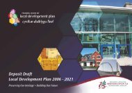
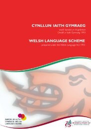
4. Use, Demand and Reasons <strong>for</strong> AccessPopulation<strong>Rhondda</strong> <strong>Cynon</strong> <strong>Taf</strong> is the second mostpopulated Authority in Wales. Beinglocated in the M4 corridor and closeto Cardiff, there are pressures <strong>for</strong>development and opportunities <strong>for</strong>outdoor recreation. <strong>The</strong> population <strong>of</strong>the twelve Area RegenerationPartnerships that cover <strong>Rhondda</strong><strong>Cynon</strong> <strong>Taf</strong> is given in Appendix One.<strong>The</strong> population is concentrated intowns and villages, with opencountryside between them. All parts<strong>of</strong> the County Borough are close toeither open access and / or the publicrights <strong>of</strong> way network. <strong>The</strong> Assessmentidentified a handful <strong>of</strong> small denselypopulated wards with few immediateaccess opportunities, but even theseareas had close connections toadjacent access. See Maps 2, 3 & 4.<strong>The</strong> most well used recreational sitesare within or close to built up areas.For example, the <strong>Taf</strong>f Trail, Garwnant,Barry Sidings Countryside Park and theLlwydcoed to Cwmbach <strong>for</strong>merrailway Corridor, Dare Valley CountryPark and Glyncornel woods arepopular. More remote sites or pathsthat cross the open countryside are notas popular or well known.Socio-Economic Pr<strong>of</strong>ile<strong>The</strong> socio-economic pr<strong>of</strong>ile <strong>of</strong> thepopulation will affect the demand anduse <strong>of</strong> access opportunities. In<strong>Rhondda</strong> <strong>Cynon</strong> <strong>Taf</strong>, only 64% <strong>of</strong>residents are economically active,below average <strong>for</strong> Wales. Carownership is also lower with 32% <strong>of</strong>households having no car, 45% onecar whilst 24% have two or more cars(the Welsh figures are 26% no car,46% one car and 28% two or more).<strong>The</strong>re is considerable variation inwealth across the County Borough,with the northern part <strong>of</strong> the Countygenerally less affluent than the south.Social inclusion is an important policypriority <strong>for</strong> the Council. See Map 5.People with no access to a car mayrely more heavily on walking andcycling <strong>for</strong> daily transport and may beexcluded from countryside activitiesthat are poorly served by publictransport. Low levels <strong>of</strong> economicactivity are frequently associated withlow household income. This mayexclude some people from taking partin countryside activity that involves acost (transport, equipment etc.).On the other hand, many retiredpeople enjoy outdoor activities such aswalking as a low cost daytime activity.Working people will tend to usecountryside recreation facilities in theevenings, at weekends and holidays.<strong>The</strong>y may use walking and cyclingroutes as part <strong>of</strong> their journey to work.10Out & About: <strong>The</strong> <strong>Rights</strong> <strong>of</strong> <strong>Way</strong> <strong>Improvement</strong> <strong>Plan</strong> <strong>for</strong> <strong>Rhondda</strong> <strong>Cynon</strong> <strong>Taf</strong>
Map Two: Population Density (per hectare)HirwaunAberdareAberamanTreherbertTreorchyMaerdyFerndaleAbercwmboiMountain AshTonypandyPorthPontypriddTonyrefailBrynnaLlanharanChurch VillageBeddauLlantrisant Llantwit FardrePontyclunKey:Population Densities(per Hectare):5 15 35 50 Reproduced from the Ordnance Survey Mapping with the permission <strong>of</strong>Her Majesty’s Stationary Office (C) Crown Copyright. Unauthorisedreproduction infringes Crown Copyright and May lead to prosecution orcivil proceedings. <strong>Rhondda</strong> <strong>Cynon</strong> <strong>Taf</strong>f CBC Licence No 10002345811Out & About: <strong>The</strong> <strong>Rights</strong> <strong>of</strong> <strong>Way</strong> <strong>Improvement</strong> <strong>Plan</strong> <strong>for</strong> <strong>Rhondda</strong> <strong>Cynon</strong> <strong>Taf</strong>
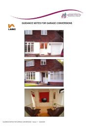
Map Three: Persons per km <strong>of</strong> <strong>Rights</strong> <strong>of</strong> <strong>Way</strong> Ward Map12Key:0 -300 people per Km <strong>of</strong> PROW (Best)301 -600 people per Km <strong>of</strong> PROW601 -900 people per Km <strong>of</strong> PROW901 -1200 people per Km <strong>of</strong> PROW1201 + people per Km <strong>of</strong> PROW (Worst)Map Reference ST0097Reproduced from the Ordnance Survey Mapping withthe permission <strong>of</strong> Her Majesty’sStationary Office(C) Crown Copyright. Unauthorised reproductioninfringes Crown Copyright amd may lead toprosecution or civil proceedings. <strong>Rhondda</strong> <strong>Cynon</strong> <strong>Taf</strong>CBC Licence No. 100023458Out & About: <strong>The</strong> <strong>Rights</strong> <strong>of</strong> <strong>Way</strong> <strong>Improvement</strong> <strong>Plan</strong> <strong>for</strong> <strong>Rhondda</strong> <strong>Cynon</strong> <strong>Taf</strong>
Map Four: Persons per hectare <strong>of</strong> Access LandKey:1 -25 people per ha <strong>of</strong> Access land (Best)26 -50 people per ha <strong>of</strong> Access land51 -100 people per ha <strong>of</strong> Access Land101 -200 people per ha <strong>of</strong> Access LandMap Reference ST0097(Open Access, Forestry CommissionWales,Common Land, Key Countryside Sites)Reproduced from the Ordnance Survey Mappingwith the permission <strong>of</strong> Her Majesty’sStationary Office201 + people per ha <strong>of</strong> Access Land(C) Crown Copyright. Unauthorised reproductioninfringes Crown Copyright amd may lead toNo Access Land (Worst)prosecution or civil proceedings. <strong>Rhondda</strong> <strong>Cynon</strong><strong>Taf</strong> CBC Licence No. 10002345813Out & About: <strong>The</strong> <strong>Rights</strong> <strong>of</strong> <strong>Way</strong> <strong>Improvement</strong> <strong>Plan</strong> <strong>for</strong> <strong>Rhondda</strong> <strong>Cynon</strong> <strong>Taf</strong>
Map Five: Welsh Index <strong>of</strong> Multiple deprivation overall deprivation index14Key:MostDeprived1 to 190191 to 380381 to 570571 to 950951 to 1896LeastDeprivedOverall Index <strong>of</strong>Deprivation and Electoral Divisions(C) Crown Copyright.<strong>Rhondda</strong> <strong>Cynon</strong> <strong>Taf</strong> CBC Licence No. 10002358 2005(C) Maps and Diagrams, Corporate Policy Team,IMD2005 Overall Index (Revised) & EDDevelopment and Regeneration Unit,Valleys Innovation Centre, Tel: 01443 665000Out & About: <strong>The</strong> <strong>Rights</strong> <strong>of</strong> <strong>Way</strong> <strong>Improvement</strong> <strong>Plan</strong> <strong>for</strong> <strong>Rhondda</strong> <strong>Cynon</strong> <strong>Taf</strong>
Map Six: Welsh Index <strong>of</strong> Multiple deprivation: Health DeprivationKey:MostDeprived1 to 190191 to 380Index <strong>of</strong> Multiple381 to 570Deprivation Health DomainBy Lower Level Super Output Areas571 to 950(C) Crown Copyright.951 to 1896<strong>Rhondda</strong> <strong>Cynon</strong> <strong>Taf</strong> CBC Licence No. 10002358 2005Least(C) Maps and Diagrams, Corporate Policy Team,DeprivedIMD2005 Health Development and Regeneration Unit,Valleys Innovation Centre, Tel: 01443 66500015Out & About: <strong>The</strong> <strong>Rights</strong> <strong>of</strong> <strong>Way</strong> <strong>Improvement</strong> <strong>Plan</strong> <strong>for</strong> <strong>Rhondda</strong> <strong>Cynon</strong> <strong>Taf</strong>
16Healthy LivingMap 6 shows the distribution <strong>of</strong> poorhealth across the County Borough. Inthe 2001 census, people were askedabout their general health. In<strong>Rhondda</strong> <strong>Cynon</strong> <strong>Taf</strong> only 61% saidtheir health was good (compared with65% <strong>for</strong> Wales), 23% said their healthwas fairly good (23%) and 16% saidtheir health was not good (Wales13%). Moderate exercise is animportant part <strong>of</strong> a healthy lifestyle.<strong>The</strong> countryside and the extensiveaccess network can provide exerciseopportunities such as walking, runningor cycling, as an alternative to themore structured indoor exercise in thelocal sports centre. <strong>The</strong> countrysideaccess network is also a free network,available all day every day, providing afar more flexible resource. Riding andlooking after horses can also provideexercise opportunities.Respondents to the publicquestionnaire recognised theimportance <strong>of</strong> the access resource <strong>for</strong>exercise or sport. <strong>The</strong> Assessment alsoidentified the need to promotephysical activity, to improve the health<strong>of</strong> the local population. Improving thehealth <strong>of</strong> the local population is animportant policy priority <strong>for</strong> theCouncil.Recreation, Leisure and TourismPublic rights <strong>of</strong> way originated fromthe tracks used by commuting workersto farms, villages and, especially in<strong>Rhondda</strong> <strong>Cynon</strong> <strong>Taf</strong>, the mines. <strong>The</strong>functional network changed in thelatter half <strong>of</strong> the twentieth century to alargely recreational network.In the past few decades there havebeen great changes in the ways peopleuse their leisure time. <strong>The</strong>opportunities available <strong>for</strong> recreationhave increased dramatically, and,higher disposable incomes alsoincrease choice. People travel furtherand more frequently <strong>for</strong> leisureactivities. Local recreationopportunities must compete, not justwith the coast or the Beacons, but alsowith holiday destinations across theUK and abroad. <strong>The</strong>re is anecdotalevidence that the use <strong>of</strong> the localaccess network has declined in the lasttwenty years or so, whilst the use <strong>of</strong>honey-pot sites and routes that arepromoted and well maintained, isincreasing.<strong>The</strong> extensive network <strong>of</strong> paths andopen access is an important amenity<strong>for</strong> recreation, leisure, tourism. <strong>The</strong>access resource is located close topeople’s homes and work places, andwithin close proximity <strong>of</strong> theestablished tourist areas <strong>of</strong> Cardiff andthe Brecon Beacons. <strong>The</strong> stunningscenery <strong>of</strong> <strong>Rhondda</strong> <strong>Cynon</strong> <strong>Taf</strong>, rich inwildlife and opportunities to enjoy theviews and recreation value <strong>of</strong> the openhillsides, has great, if undevelopedtourism potential.Commuting and Utility UseIn the census <strong>of</strong> those who work, 60%drive to work while only 10% walkand 2% cycle to work. Despite thechanges in the use <strong>of</strong> the accessnetwork described above, some urbanroutes still contribute to the functionaltransport network and this role mayincrease again in the future. Climatechange, rising oil prices and healthyliving, will encourage more walkingand cycling, <strong>of</strong>ten associated withincreasing public transport use. Alsoas mentioned above, low carownership levels can lead to socialexclusion if there is no access t<strong>of</strong>acilities and services <strong>for</strong> pedestrians,cyclists and public transport users.Out & About: <strong>The</strong> <strong>Rights</strong> <strong>of</strong> <strong>Way</strong> <strong>Improvement</strong> <strong>Plan</strong> <strong>for</strong> <strong>Rhondda</strong> <strong>Cynon</strong> <strong>Taf</strong>
Latent Demand<strong>The</strong> guidance produced by the WelshAssembly government, states that theROWIP should assess“…the extent towhich local rights <strong>of</strong> way meet thepresent and likely future needs <strong>of</strong> thepublic.” This would indicate that latentdemand should also be assessed.<strong>The</strong> Assessment identified thefollowing latent demands:• <strong>The</strong> increasing demand <strong>for</strong> <strong>of</strong>f roadvehicle use, especially motorbikescurrently illegally using routes andopen countryside.• With unacceptable levels <strong>of</strong> poorhealth and rising obesity, the accessnetwork can provide a sustainable,low cost exercise opportunity.• Access <strong>for</strong> all routes: although anumber <strong>of</strong> the routes across theCounty Borough are open <strong>for</strong> thoseusing mobility aids, there is ademand <strong>for</strong> a greater diversity <strong>of</strong>paths, and publicity material, <strong>for</strong>those using wheelchairs etc..Mobility scooters are becomingmore advanced allowing users totravel further. <strong>The</strong>se larger scootersrequire wider access controls thantraditional wheelchairs.• More Bridleways. <strong>The</strong>re are 743 km<strong>of</strong> public rights <strong>of</strong> way <strong>of</strong> this only82 km are bridleways, most <strong>of</strong> whichare in the Brynna ward on the borderwith Bridgend County BoroughCouncil.• More Byways. Only 15 km <strong>of</strong>Byways, the majority <strong>of</strong> these tracksare in a poor condition.• Tourist use, combined witheconomic regenerationopportunities.To address latent demand, thefollowing issues identified in thepublic consultation, need to beconsidered.• Better in<strong>for</strong>mation about routes• Need to control illegal motorbikeuse• Better provision <strong>for</strong> Access <strong>for</strong> All• Better maintenance <strong>of</strong> paths, signageand path furnitureConflicting InterestsSome conflict <strong>of</strong> interests betweenusers <strong>of</strong> the paths and sites areidentified through customer servicesand ranger contacts. Physical damage<strong>of</strong> path surfaces by horses and <strong>of</strong>f roadvehicles, and illegal use <strong>of</strong> paths andsites by motorcycle scramblers are themost frequent complaints. This wasreflected in responses to the publicquestionnaire. Potential conflictbetween access and natureconservation has also been highlightedin specific circumstances.Conflicts with landowners do occurwhere footpaths are obstructed,though these conflicts are <strong>of</strong>ten swiftlydealt with reopening and improvingaccess. <strong>The</strong>re was initial landownerapprehension regarding the new openaccess created by Countryside and<strong>Rights</strong> <strong>of</strong> <strong>Way</strong> Act. <strong>The</strong> Local AccessForum provides a mechanism <strong>for</strong>dealing any concerns, buildingrelationships and opencommunication with the farmingcommunity. Publicity and guidancefrom the CCW also contribute tomanaging any potential conflictsbetween users and landowners. TirG<strong>of</strong>al and Tir Cynnal funding <strong>for</strong>farmers is dependant on compliancewith <strong>Rights</strong> <strong>of</strong> <strong>Way</strong> law.Out & About: <strong>The</strong> <strong>Rights</strong> <strong>of</strong> <strong>Way</strong> <strong>Improvement</strong> <strong>Plan</strong> <strong>for</strong> <strong>Rhondda</strong> <strong>Cynon</strong> <strong>Taf</strong>17
5. Current Provision18<strong>The</strong> Public <strong>Rights</strong> <strong>of</strong> <strong>Way</strong> Network<strong>The</strong> public rights <strong>of</strong> way network is arich legacy, part <strong>of</strong> the ruralcommunications network thatoriginated be<strong>for</strong>e the era <strong>of</strong> surfacedroads and motor vehicles. Over time,it has evolved into a recreational andfunctional web, that enables people toexplore the countryside on foot, onhorseback, on a bicycle or in avehicle.<strong>Rhondda</strong> <strong>Cynon</strong> <strong>Taf</strong> has approximately2000 individual paths with a totallength <strong>of</strong> 743km, <strong>of</strong> which, 646km arefootpaths, 82km are bridleways and15km are by-ways open to all traffic.Details <strong>of</strong> the network across theCounty and on a ward-by-ward basisare presented in the Assessment.Maintaining and enhancing theseroutes is a priority if the increasedrecreational and sustainable transportdemands that will be put on the rights<strong>of</strong> way network in the years to comeare to be met. Map 7 shows the extent<strong>of</strong> access opportunities.<strong>The</strong> State <strong>of</strong> the Network<strong>The</strong> Assessment considered thecurrent condition <strong>of</strong> the rights <strong>of</strong> waynetwork in some detail. <strong>The</strong> Wales<strong>Rights</strong> <strong>of</strong> <strong>Way</strong> Condition Survey2002 found that <strong>Rhondda</strong> <strong>Cynon</strong> <strong>Taf</strong>achieved an ‘easy to use’ figure onall paths <strong>of</strong> 53% (10% sample). <strong>The</strong>National Assembly WalesPer<strong>for</strong>mance Indicator (5% sample)shows that the percentage <strong>of</strong> pathsthat are easy to use in <strong>Rhondda</strong><strong>Cynon</strong> <strong>Taf</strong> has increased from 21% in2001/2002, to 64% in 2004/2005,67% in 2005/06 and 73% in 2006/7.Legally Defined<strong>The</strong> National Parks and Access to theCountryside Act 1949 introduced theprocedures <strong>for</strong> recording publicrights on definitive maps andstatements. <strong>The</strong>y are so calledbecause they can be produced incourt as conclusive evidence <strong>of</strong>those rights. <strong>The</strong> Act also requiredLocal Highway Authorities tomaintain these routes at publicexpense.Glamorgan County Councilpublished a draft map and statementon the 31st January 1955. <strong>The</strong> mapand statement had a relevant date <strong>of</strong>the 14th September 1954. Followingthe resolution <strong>of</strong> objections, aprovisional map and statement waspublished on the 1st May 1964, andfollowing further objections adefinitive map and statement waspublished on the 4th August 1970.Further reviews were carried out onthe areas now found in <strong>Rhondda</strong><strong>Cynon</strong> <strong>Taf</strong>. <strong>The</strong> definitive map andstatement <strong>for</strong> <strong>Rhondda</strong> Valley has arelevant date <strong>of</strong> 6th November 1992,and the <strong>Cynon</strong> Valley has a relevantdate <strong>of</strong> 15th December 1995. <strong>The</strong>relevant date <strong>of</strong> the <strong>Taf</strong>f Ely definitivemap and statement is 1st January1971. This is the date up to whichthe in<strong>for</strong>mation contained in theDefinitive Map and statement iscorrect.ManagementCurrent staff regularly involved inmanaging Public <strong>Rights</strong> Of <strong>Way</strong> andopen access in <strong>Rhondda</strong> <strong>Cynon</strong> <strong>Taf</strong>are as follows:• Countryside Manager• Public <strong>Rights</strong> <strong>of</strong> <strong>Way</strong> Officer• Countryside Projects Officer (20%)• 3 Countryside Rangers• 3 <strong>Rights</strong> <strong>of</strong> <strong>Way</strong> Rangers(Practical Team)<strong>Rhondda</strong> <strong>Cynon</strong> <strong>Taf</strong> CBC isresponsible <strong>for</strong> the day-to-daymanagement <strong>of</strong> the public rights <strong>of</strong>way network. <strong>The</strong> duties include thecontinual review <strong>of</strong> the definitivemap through the processing <strong>of</strong>Out & About: <strong>The</strong> <strong>Rights</strong> <strong>of</strong> <strong>Way</strong> <strong>Improvement</strong> <strong>Plan</strong> <strong>for</strong> <strong>Rhondda</strong> <strong>Cynon</strong> <strong>Taf</strong>
applications <strong>for</strong> modification orders,diversion orders, extinguishmentorders and creation orders.<strong>The</strong> Council currently has threeagency agreements with CommunityCouncils, which allow them to carryout basic maintenance works <strong>for</strong> anannual payment by the Council.<strong>The</strong>re is also an agency agreementwith Brecon Beacons National Parkthat allows them to carry outmaintenance works, and to carry outdiversions and other legal orders onbehalf <strong>of</strong> the Council.PublicityLimited publicity and promotion <strong>of</strong>rights <strong>of</strong> way and open access hasbeen carried out in <strong>Rhondda</strong> <strong>Cynon</strong><strong>Taf</strong>. Recent events such as a WalkingFestival, and the creation <strong>of</strong> acircular walk around Pontypridd, arebeing encouraged to raise the pr<strong>of</strong>ile<strong>of</strong> the public rights <strong>of</strong> way in<strong>Rhondda</strong> <strong>Cynon</strong> <strong>Taf</strong>. Promotion hasalso been undertaken by otherorganisations, <strong>for</strong> example, Walkingthe <strong>Way</strong> to Health, GroundworkLoops and Links project and theLlantrisant Bunny Walks.Open Access Land<strong>The</strong> Countryside and <strong>Rights</strong> <strong>of</strong> <strong>Way</strong> Act2000 created a new statutory right <strong>of</strong>access on foot to certain types <strong>of</strong> opencountryside. This land comprisesmountain (over 600 metres),moorland, heath, down and registeredcommon land. On 28th May 2005, theAct made these designated areas opento public use. Temporary closures arepermitted, subject to a specificprocedure. Maps showing thedesignated areas <strong>of</strong> public access arelocated in the Council’s CountrysideSection, and in<strong>for</strong>mation is alsoavailable on the Countryside Council<strong>for</strong> Wales’ website (www.ccw.gov.uk).All relevant updated in<strong>for</strong>mation,including any restrictions, can befound on this website. <strong>The</strong> openaccess land is also shown on theOrdnance Survey Explorer series.<strong>The</strong>re are 4865 hectares <strong>of</strong> openaccess land found in <strong>Rhondda</strong> <strong>Cynon</strong><strong>Taf</strong>. Map Seven includes these areas.Forestry Commission Wales landAt the launch <strong>of</strong> open access in Wales,the Forestry Commission dedicated alltheir own land <strong>for</strong> public access.Forest on leased land has not beenClaimed <strong>Rights</strong> <strong>of</strong> <strong>Way</strong>sdedicated though there are plans toUnder Section 53 <strong>of</strong> the Wildlife and dedicate many <strong>of</strong> these areas. <strong>The</strong>re isCountryside Act 1981, anyone may 5197 hectares <strong>of</strong> dedicated <strong>for</strong>estryapply to the Council to add a right <strong>of</strong> open access land within <strong>Rhondda</strong>way to, or delete from the definitive <strong>Cynon</strong> <strong>Taf</strong>. Map Seven includes thesemap and statement. An application areas.can also be made to upgrade or In <strong>Rhondda</strong> <strong>Cynon</strong> <strong>Taf</strong> a number <strong>of</strong>downgrade a right <strong>of</strong> way already rights <strong>of</strong> way cross Forestryshown on the map and statement. Commission land. For a number <strong>of</strong><strong>The</strong> majority <strong>of</strong> applications are to years the Forestry Commission hasadd rights <strong>of</strong> way to the map, the over planted trees on their land thatpresumption being that they exist but contain rights <strong>of</strong> ways and this hashave not previously been recorded. resulted in a high percentage <strong>of</strong> them<strong>The</strong> Council has a duty to fully being obstructed, though the <strong>for</strong>estinvestigate the claims, to uncover tracks provide alternative access.evidence to support or reject the Negotiations are currently being heldapplication made under the above with the Forestry Commission WalesAct.regarding the plans to reopen rights <strong>of</strong>19Out & About: <strong>The</strong> <strong>Rights</strong> <strong>of</strong> <strong>Way</strong> <strong>Improvement</strong> <strong>Plan</strong> <strong>for</strong> <strong>Rhondda</strong> <strong>Cynon</strong> <strong>Taf</strong>
way on their land after harvesting.Horse riding and carriage driving arepermitted on Forestry CommissionWales land, but again not necessarilyon leased land, <strong>for</strong> example StGwynno’s Forest. Cycling andmountain biking is allowed on <strong>for</strong>estryroads and tracks. A copy <strong>of</strong> theForestry Commissions Cycle Code canbe seen on their website(www.<strong>for</strong>estry.gov.uk/recreation).Members <strong>of</strong> the public must be awarethat <strong>for</strong>ests are a working environmentand that diversions to roads and tracksmay be required.Permissive access is also available onland in private ownership, particularlywhere the landowner is involved ingrant schemes such as the WoodlandGrant Scheme/ Better Woodlands <strong>for</strong>Wales and Tir G<strong>of</strong>al. Under theseschemes public access alongpermissive routes is provided underthe terms <strong>of</strong> the grant scheme, but only<strong>for</strong> the duration <strong>of</strong> the scheme inquestion. <strong>The</strong>se routes are notincluded on Map 7. Tir G<strong>of</strong>alpermissive access routes and accessland are publicised on the CCWwebsite (www.ccw.gov.uk).20Council-owned land including KeyCountryside Sites, Local NatureReserves, Country Parks and PublicParks<strong>The</strong> majority <strong>of</strong> Council owned land isavailable <strong>for</strong> public access on foot.Key Countryside Sites provide 1280hectares <strong>of</strong> land available <strong>for</strong> publicaccess, (including Glyncornel LocalNature Reserve, 36 hectares, and DareValley Country Park, 176 hectares).<strong>The</strong>re are a number <strong>of</strong> public parks inthe area with Aberdare Park, Aberdareand Ynysangharad Park, Pontypriddhaving the highest pr<strong>of</strong>ile. Some KeyCountryside Sites are <strong>for</strong>mer spoil tipsthat have been reclaimed by theCouncil, however, some <strong>for</strong>mer tipshave no public access due to healthand safety issues. Map Seven onlyincludes the areas with public access.Permissive PathsA number <strong>of</strong> disused railway linesowned by the Council are managed<strong>for</strong> public access and are included onMap 7. <strong>The</strong> surface <strong>of</strong> the routes varies.Routes are generally open topedestrians and cyclists, with someroutes shared by horses. <strong>The</strong> <strong>Taf</strong>f Trailand the Dare Aman Line in the <strong>Cynon</strong>Valley are prime examples <strong>of</strong>permissive access on Council ownedland.Highway Network<strong>Rhondda</strong> <strong>Cynon</strong> <strong>Taf</strong> is responsible <strong>for</strong>all maintainable highways in the area.This responsibility includes all mainroads and footways adjacent tohighways in the County Boroughshown on the list <strong>of</strong> streets. <strong>The</strong> list <strong>of</strong>streets records the highways that aHighway Authority is liable tomaintain at public expense, and is amandatory requirement.Adopted highways <strong>for</strong>m an importantconnection between the communityand the surrounding countryside. Forthe majority <strong>of</strong> people, the adoptedhighway will <strong>for</strong>m a part <strong>of</strong> anyjourney into the countryside or toreach any <strong>for</strong>m <strong>of</strong> countryside access.<strong>The</strong> Assessment identified a specificconcern that some highways, that linkto public rights <strong>of</strong> way, are <strong>of</strong> uncertainlegal status.A number <strong>of</strong> public rights <strong>of</strong> way havebecome adopted highways, typicallythrough the development <strong>of</strong> housingestates. <strong>The</strong>se now follow metalledroads <strong>for</strong>ming part <strong>of</strong> the highwaynetwork.<strong>The</strong> Council has a duty to signpost allfootpaths, bridleways and bywaysfound on the definitive map andstatement where they leave themetalled road.Out & About: <strong>The</strong> <strong>Rights</strong> <strong>of</strong> <strong>Way</strong> <strong>Improvement</strong> <strong>Plan</strong> <strong>for</strong> <strong>Rhondda</strong> <strong>Cynon</strong> <strong>Taf</strong>
Map Seven: <strong>The</strong> Access NetworkHirwaunAberdareAberamanTreherbertMaerdyAbercwmboiMountain AshTreorchyFerndaleTonypandyPorthPontypriddTonyrefailChurch VillageLlanharanBrynnaBeddauLlantrisantLlantwit FardrePontyclunReproduced from the Ordnance Survey Mapping withthe permission <strong>of</strong> Her Majesty’s Stationary Office (C)Key:Crown Copyright. Unauthorised reproduction infringesPublic <strong>Rights</strong> <strong>of</strong> <strong>Way</strong>Crown Copyright and may lead to prosecution or civilproceedings. <strong>Rhondda</strong> <strong>Cynon</strong> <strong>Taf</strong> CBC Licence No.Access Area10002345821Out & About: <strong>The</strong> <strong>Rights</strong> <strong>of</strong> <strong>Way</strong> <strong>Improvement</strong> <strong>Plan</strong> <strong>for</strong> <strong>Rhondda</strong> <strong>Cynon</strong> <strong>Taf</strong>
6. Assessment and Evaluation22<strong>The</strong> Assessment, Issues Paper and theirassociated consultations haveidentified a range <strong>of</strong> issues to beaddressed by the <strong>Rights</strong> <strong>of</strong> <strong>Way</strong><strong>Improvement</strong> <strong>Plan</strong>. This chapter drawstogether this in<strong>for</strong>mation, and presentsa framework <strong>of</strong> six objectives <strong>for</strong> theaction plan.<strong>The</strong> VisionTo manage, develop and promote thenetwork <strong>of</strong> local public rights <strong>of</strong> wayand other countryside access, in orderto satisfy present and likely futuredemand <strong>for</strong> the enjoyment <strong>of</strong> thecountryside, open-air recreation,exercise and ‘access <strong>for</strong> all’.Objective 1:Promote outdoor countryside activity<strong>for</strong> health, regeneration, tourism andrecreation.Health, regeneration, tourism andrecreation are all policy priorities <strong>for</strong>the Welsh Assembly Government and<strong>for</strong> the Council. <strong>The</strong> Assessment hasidentified that <strong>Rhondda</strong> <strong>Cynon</strong> <strong>Taf</strong> hasa superb resource <strong>for</strong> outdoorcountryside activity in the rights <strong>of</strong>way network, our Parks and KeyCountryside sites and the new OpenAccess land. This resource has hugepotential both <strong>for</strong> local people to use,free <strong>of</strong> charge, and as a driver <strong>for</strong>regeneration and tourism. But it is alsoa well-kept secret. <strong>The</strong> resource isunderused, with little promotion orpublicity and currently has a lowpriority <strong>for</strong> investment anddevelopment.General health standards in <strong>Rhondda</strong><strong>Cynon</strong> <strong>Taf</strong> are below the average <strong>for</strong>Wales. <strong>The</strong> Active Living Partnership,set up by the Health and WellbeingPartnership (under the <strong>Rhondda</strong> <strong>Cynon</strong><strong>Taf</strong> Community <strong>Plan</strong> ‘A Better Life’)looks at promoting physical activity <strong>for</strong>social, mental and physical health andwellbeing. Not <strong>for</strong>getting the benefits<strong>of</strong> fun and relaxation!<strong>The</strong> Welsh Assembly Government hastargets in ‘Climbing Higher’, theirstrategy <strong>for</strong> sport and physical activity.<strong>The</strong>se include;• access to a footpath or cycle pathwithin a ten-minute walk, <strong>for</strong> 95% <strong>of</strong>the population, and• <strong>for</strong> everyone to live within a sixminute walk (300m) <strong>of</strong> a naturalgreen space.By these measures, which consider theavailability <strong>of</strong> the access resource, it islikely that most residents <strong>of</strong> <strong>Rhondda</strong><strong>Cynon</strong> <strong>Taf</strong> are already very well served.<strong>The</strong> Assembly has also set a target <strong>for</strong>the use <strong>of</strong> the access resource;• Percentage <strong>of</strong> people using thenatural environment <strong>for</strong> outdooractivities to rise from 36% to 60%.A question ‘Do you use thecountryside or parks <strong>for</strong> outdooractivities?’ was included in theCouncil’s 2006 Residents’ Survey toestablish a baseline figure <strong>for</strong> thisindicator. A total <strong>of</strong> 68.8% <strong>of</strong>respondents reported that they use thecountryside and parks <strong>for</strong> outdooractivities. <strong>The</strong> survey is repeated at twoyearly intervals and a repeat <strong>of</strong> thequestion will be requested in 2010.Regeneration and tourism promotionare key elements <strong>of</strong> the Community<strong>Plan</strong> and are being addressed throughArea Regeneration Partnerships,Communities First, the LocalDevelopment <strong>Plan</strong> and the TourismStrategy. <strong>The</strong> access network is anexcellent resource <strong>for</strong> environmentaltourism, providing access to dramaticscenery, stunning wildlife, historiclandscapes and visitor attractions.Again the potential is largelyuntapped. With unemployment andeconomic inactivity above the nationalaverage, our countryside and diverselandscape should be utilised as aresource <strong>for</strong> regeneration.Out & About: <strong>The</strong> <strong>Rights</strong> <strong>of</strong> <strong>Way</strong> <strong>Improvement</strong> <strong>Plan</strong> <strong>for</strong> <strong>Rhondda</strong> <strong>Cynon</strong> <strong>Taf</strong>
Objective 2:Promote walking and cycling astransport options.Climate change is a global issue thatneeds to be tackled at every level. <strong>The</strong>promotion <strong>of</strong> walking and cycling assustainable transport options cancontribute to this, linked with thelocation <strong>of</strong> facilities and services inplaces that people can reach withoutdriving. <strong>The</strong> Regional Transport <strong>Plan</strong>(RTP) and the Local Development <strong>Plan</strong>(LDP) will be the key Council policydocuments to tackle these issues. <strong>The</strong>access network is an important part <strong>of</strong>the integrated highway network. 18%<strong>of</strong> the people who responded to thepublic consultation use the accessnetwork to get from A to B. Makingthe walking or cycling experienceeasier and more enjoyable will beimportant in changing people’sattitudes to transport choices.Active commuting is a key theme <strong>for</strong>the Active Living Partnership, asregular exercise as part <strong>of</strong> the dailyroutine is central to a healthy lifestyle.Improving access to services andfacilities <strong>for</strong> those without a car is alsoa key policy <strong>for</strong> social inclusion. This isparticularly relevant <strong>for</strong> children, somedisabled people and <strong>for</strong> older peoplewho may rely on the access network<strong>for</strong> independent travel.Improved and targeted publicity andpromotion <strong>of</strong> walking and cyclingopportunities will be important <strong>for</strong> theachievement <strong>of</strong> this objective.Objective 3:Protect the access resource (includingPublic <strong>Rights</strong> <strong>of</strong> <strong>Way</strong>, highways, accessland and Council facilities).<strong>The</strong> Assessment identified the natureand extent <strong>of</strong> the access resource andsome <strong>of</strong> the pressures on it. <strong>The</strong> lawrequires the Local Highway Authorityto undertake a range <strong>of</strong> specific dutiesto protect and manage the <strong>Rights</strong> <strong>of</strong><strong>Way</strong> Network. Further duties are beingintroduced as the Countryside and<strong>Rights</strong> <strong>of</strong> <strong>Way</strong> Act 2000, NaturalEnvironment and Rural CommunitiesAct 2006 and the CleanNeighbourhood Act 2006 areimplemented. <strong>The</strong> resources currentlyavailable are insufficient to adequatelyaddress all <strong>of</strong> these issues.<strong>The</strong> Council will include policies inthe Local Development <strong>Plan</strong> relatingto the protection <strong>of</strong> Public <strong>Rights</strong> <strong>of</strong><strong>Way</strong>, open access and recreation sites.<strong>The</strong> Regional Transport <strong>Plan</strong> will alsocontain policies regarding the accessresource.Managing the network involves jointworking with the Council’s highwaymanagers, development control andlegal <strong>of</strong>ficers as well as practical workon the ground. Joint working withother major landowners, such as theForestry Commission Wales is alsoimportant.Protection also embraces issues suchas rubbish dumping and anti-socialbehaviour that can damage theresource as well as deterring users.Out & About: <strong>The</strong> <strong>Rights</strong> <strong>of</strong> <strong>Way</strong> <strong>Improvement</strong> <strong>Plan</strong> <strong>for</strong> <strong>Rhondda</strong> <strong>Cynon</strong> <strong>Taf</strong>23
Objective 4:Improve provision <strong>for</strong> walkers,cyclists, horse riders, <strong>of</strong>f road vehiclesand users with mobility and sensorydisabilities.<strong>The</strong> survey <strong>of</strong> the definitive map andother access opportunities to producethe total access map has highlightedclear gaps in the network <strong>for</strong> specificuser groups. <strong>The</strong> results <strong>of</strong> the publicconsultation also support thisconclusion. <strong>The</strong>re is a lack <strong>of</strong>bridleways and byways in most <strong>of</strong> theCounty Borough and there is demand<strong>for</strong> additional facilities <strong>for</strong> horse-riders,<strong>of</strong>f-road vehicles and cyclists. It is notknown if additional facilities arerequired <strong>for</strong> carriage drivers. <strong>The</strong>Community <strong>Plan</strong> supports the need toprovide opportunities <strong>for</strong> people. Offroadmotor biking is a popular activitythroughout the County Borough.Un<strong>for</strong>tunately most current activity isillegal, the physical scars are clear onthe landscape and public support islow. <strong>The</strong>re is little legal provision andthe communication between the usergroup, the Police and the generalpublic, is poor. Through theCommunity Safety Partnership an OffRoad Motorcycle Coordinator hasbeen employed and the Off-RoadMotorcycle Steering Group has beenset up.<strong>The</strong>re is a growing number <strong>of</strong> Access<strong>for</strong> All routes across the CountyBorough with improved accessopportunities <strong>for</strong> those with mobilitydifficulties. To meet the requirements<strong>of</strong> the Disability Discrimination Act,and to promote social inclusion,further work is required. <strong>The</strong> publicconsultation results showed that thepublic support this action.As part <strong>of</strong> the Local Development<strong>Plan</strong>, the Local Transport <strong>Plan</strong> andsome major development schemes,integrated community routes are beingincorporated with future developmentsto improve the access provision.Opportunities may arise <strong>for</strong> improvedprovision in association with fundingopportunities. A current example isthe development <strong>of</strong> the <strong>Cynon</strong> Trail inassociation with the Heads <strong>of</strong> theValleys environmental programme.Continued maintenance <strong>of</strong> the pathnetwork and, in particular, theupdating, <strong>of</strong> the definitive map(objective 6) are important <strong>for</strong> thecontinuing improvement <strong>of</strong> the rights<strong>of</strong> way network.24Out & About: <strong>The</strong> <strong>Rights</strong> <strong>of</strong> <strong>Way</strong> <strong>Improvement</strong> <strong>Plan</strong> <strong>for</strong> <strong>Rhondda</strong> <strong>Cynon</strong> <strong>Taf</strong>
Objective 5:Involve local community andvoluntary organisations in thedevelopment, promotion and use <strong>of</strong>access opportunities.<strong>The</strong> public consultation and theAssessment, identified a number <strong>of</strong>issues relating to publicity andpromotion. In consultations with AreaRegeneration Partnerships,Communities First and CommunityCouncils the importance <strong>of</strong> grassrootsparticipation was recognised. Accessis a popular local issue and manycommunities are taking actions<strong>for</strong>ward to improve access. Publicityand promotion developed <strong>for</strong> specificaudiences is also likely to be moresuccessful.User groups are able to contribute tothe discussion about access via theLocal Access Forum, but the responseto the Out & About consultations hasbeen disappointing. New ways <strong>of</strong>working with user groups are beinginvestigated as a result. Localmembership <strong>of</strong> user groups such as theRamblers, BHS, CTC etc. is probablyquite small, however there are adiverse range <strong>of</strong> local voluntary andcommunity groups who may have aninterest in access matters. <strong>The</strong> BritishHorse Society has recently establisheda bridleways group and a bridleways<strong>of</strong>ficer in <strong>Rhondda</strong> <strong>Cynon</strong> <strong>Taf</strong>.Encouraging community and voluntaryparticipation is also seen as a way <strong>of</strong>reaching people who don’t currentlyuse the access resource and toinvestigate barriers to use and thepotential to realise latent demand.Among the public at large, knowledge<strong>of</strong> <strong>Rights</strong> <strong>of</strong> <strong>Way</strong> and open access islow. <strong>The</strong> Library Service will beinvolved in developing theseopportunities.Objective 6:Develop a more efficient <strong>of</strong>ficemanagement system <strong>for</strong> statutory<strong>Rights</strong> <strong>of</strong> <strong>Way</strong> work including theDefinitive Map.<strong>The</strong> Issues Paper, the Assessment andthe consultation responses highlightedthe need <strong>for</strong> improvement <strong>of</strong> the <strong>of</strong>ficemanagement systems <strong>for</strong> <strong>Rights</strong> <strong>of</strong> <strong>Way</strong>work. <strong>The</strong> Definitive Map andStatement and the computerisedmapping system were identified aspriorities. Paper based systems,developed in the 1950’s, must bereplaced by modern computersystems. An up to date definitive mapand efficient data management areessential to progress all the otherobjectives.<strong>The</strong> Countryside and <strong>Rights</strong> <strong>of</strong> <strong>Way</strong> Act2000, includes a number <strong>of</strong> newstatutory functions to be carried out toimprove public in<strong>for</strong>mation andaddress internal procedures.<strong>The</strong> Welsh Assembly government’s’Climbing Higher’ environmentaltargets have been identified asindicators <strong>for</strong> this Action <strong>Plan</strong>.Out & About: <strong>The</strong> <strong>Rights</strong> <strong>of</strong> <strong>Way</strong> <strong>Improvement</strong> <strong>Plan</strong> <strong>for</strong> <strong>Rhondda</strong> <strong>Cynon</strong> <strong>Taf</strong>25
7. Actions7.1 Statement <strong>of</strong> ActionThis section focuses on the proposed actions. First the aim and objectives arelisted. For each objective, the actions are described and each is classified as aservice action (strategic or routine) or a project (existing or new). This isfollowed by a tabular summary including; resources, timetabling, leadorganisation and partners.ss – Strategic Servicers – Routine Serviceep – Existing Projectnp – New Project* – Statutory dutyEstimated Costs£ ~ less than £5000££ ~ £5000 - £30000£££ ~ more than £30,000c currenta additionalCAP – project included in the Countryside Action ProgrammeAimTo manage, develop and promote the network <strong>of</strong>local public rights <strong>of</strong> way and other countrysideaccess, in order to satisfy present and likely futuredemand <strong>for</strong> the enjoyment <strong>of</strong> the countryside, openairrecreation, exercise and ‘access <strong>for</strong> all’.26Out & About: <strong>The</strong> <strong>Rights</strong> <strong>of</strong> <strong>Way</strong> <strong>Improvement</strong> <strong>Plan</strong> <strong>for</strong> <strong>Rhondda</strong> <strong>Cynon</strong> <strong>Taf</strong>
ObjectivesObjective 1:Promote outdoor countryside activity<strong>for</strong> health, regeneration, tourism andrecreationObjective 2:Promote walking and cycling astransport optionsObjective 3Protect the access resource (includingPROW, highways, access land andCouncil facilities)Objective 4:Improve provision <strong>for</strong> walkers, cyclists,horse riders, <strong>of</strong>f road vehicles andusers with disabilitiesObjective 5:Involve local community and voluntaryorganisations in the development,promotion and use <strong>of</strong> access opportunitiesObjective 6:Develop a more efficient <strong>of</strong>ficemanagement system <strong>for</strong> statutory<strong>Rights</strong> <strong>of</strong> <strong>Way</strong> work including theDefinitive MapOut & About: <strong>The</strong> <strong>Rights</strong> <strong>of</strong> <strong>Way</strong> <strong>Improvement</strong> <strong>Plan</strong> <strong>for</strong> <strong>Rhondda</strong> <strong>Cynon</strong> <strong>Taf</strong>27
Objective 1: Promote outdoor countryside activity <strong>for</strong> health, regeneration,tourism and recreation.Strategic Service ActionsInput to ActiveLivingPartnershipDevelop linkswith EducationInput toCouncil’sTourismStrategy InvolvelibrariesPartnership set up under the Community Strategy Health and Wellbeing Partnership topromote physical activity, meets 4 times a year and aims to add value through jointworking.A twice-yearly meeting is proposed, to consider the use <strong>of</strong> the local countryside by schools<strong>for</strong> curriculum study/activity and in<strong>for</strong>mal learning such as sports clubs or Duke <strong>of</strong>Edinburgh award.A twice-yearly meeting with Council Tourism Officers is proposed to develop thepotential <strong>of</strong> walking, cycling and horse riding tourism. <strong>The</strong> Council’s library serviceprovides in<strong>for</strong>mation about access and local walking opportunities. It is also amechanism <strong>for</strong> communicating with local people. <strong>The</strong>re is potential to use this resourcemore effectively. Quarterly meetings with the library service are proposed.MarketingLiaise withNeighbours<strong>The</strong> new marketing <strong>of</strong>ficer <strong>for</strong> Leisure, Parks and Countryside will co ordinate the promotion<strong>of</strong> <strong>Rights</strong> <strong>of</strong> <strong>Way</strong> and Open Access, alongside other services. A marketing strategy should bea priority.<strong>The</strong> Living Space Action Programme provides a mechanism <strong>for</strong> identifying joint projects. <strong>The</strong>twice-yearly meeting <strong>of</strong> the SE Wales <strong>Rights</strong> <strong>of</strong> <strong>Way</strong> <strong>of</strong>ficers will address cross-border issues.Existing ProjectsWalking the<strong>Way</strong> 2 Health(CAP) / WalkingWalesValleys WalkingFestival (CAP)Loops and Links(CAP)School NatureTrailsTen projects in Communities First Partnerships were funded to Dec 2006. <strong>The</strong>se shouldcontinue, utilising the trained walk leaders and risk assessed walking routes developedas part <strong>of</strong> the project.Walking is a feature <strong>of</strong> the PALS and STARs projects. Various family learning projectsinclude walking and cycling <strong>for</strong> health. Walking Wales grant funding is available <strong>for</strong> theperiod 2007-10.<strong>The</strong> Festival was established in 2005 and aims to promote walking <strong>for</strong> local people andvisitors. Groundwork project to link valley communities and promote regenerationthrough activity tourism. 1st phase in the north complete, 2nd phase in the south <strong>of</strong> theCounty is being developed.Developing nature trails in conjunction with the Local Biodiversity Action <strong>Plan</strong> usingKey Countryside Sites and public rights <strong>of</strong> way.Mentro AllanGuided walksJoint projectsLeafletsNew ProjectsProvide on-linein<strong>for</strong>mationCircular routesFacilitiesPublic TransportLottery funding stream <strong>for</strong> countryside access targeted at disadvantaged groups in parts<strong>of</strong> <strong>Rhondda</strong> <strong>Cynon</strong> <strong>Taf</strong>.Existing programmes <strong>of</strong> Ramblers Groups, including short stepping stones walks,biodiversity walks etc. Also Bike events (CAP). Potential <strong>for</strong> development.Promote long distance routes (CAP), Pontypridd Circular Walk (CAP). For example,Ramblers Bunny Walks, Daerwynno cycle paths.Walking, cycling, horse riding, access <strong>for</strong> all and <strong>of</strong>f road vehicles via the internet.Develop and promote new circular / linear routes <strong>for</strong> a variety <strong>of</strong> target audiences. E.g.Area 8 walk, Area 7 walk.Dare Valley visitor centre facilities, equestrian tourism (CAP), Cross border horse routes,Bwllfa project (CAP), Bike hire.Working with providers on promotion and improved links. Including disabled accessand social inclusion. Public transport map.Out & About: <strong>The</strong> <strong>Rights</strong> <strong>of</strong> <strong>Way</strong> <strong>Improvement</strong> <strong>Plan</strong> <strong>for</strong> <strong>Rhondda</strong> <strong>Cynon</strong> <strong>Taf</strong>
Objective 1: Promote outdoor countryside activity <strong>for</strong> health,regeneration, tourism and recreation.No Type Action Resources Year Lead and Partners1 ss Active Living people c From 2006 Countryside/ ALP2 ss Education people c From 2007 Countryside / Education3 ss Tourism Strategy people c From 2007 Countryside / Tourism4 ss Libraries people c From 2007 Countryside / Libraries5 ss Marketing people££c/a6 ss Liaise withneighbours7 ep Walking the<strong>Way</strong> 2 Health /Walking Wales8 ep Valleys WalkingFestivalpeople cFrom 2007 Leisure, Parks +CountrysideFrom 2007 Countryside / SE WalesROWOpeople c/a 2006 Countryside / LHB / CF/SCWpeople c9 ep Loops and Links people££c/a10 ep School NatureTrailspeople c/a11 ep Mentro Allan people££a12 ep Guided walksand bike ridesFrom 2005 Countryside / Tourism2006-9 Countryside /GroundworkFrom 2006 Countryside / Schools2007- 2010 ALP/ Sustranspeople c/a ongoing Ramblers/ Glyncorneletc.13 ep Joint Projects people c ongoing Bridgend, NPT,Countryside14 ep Leaflets people£ c/a15 np Provide on-linein<strong>for</strong>mation16 np Circular routesand database17 np Visitor facilities(new andimproved)people £ apeople£ a18 np Public transport people£ c/aongoingVoluntary organisationsFrom 2007 Countryside / ITFrom 2007 Countryside / IT / AreaRegenerationPartnerships£££ a From 2007 CountrysideFrom 2007 Countryside / VoluntarySector/ Transportation/operatorsOut & About: <strong>The</strong> <strong>Rights</strong> <strong>of</strong> <strong>Way</strong> <strong>Improvement</strong> <strong>Plan</strong> <strong>for</strong> <strong>Rhondda</strong> <strong>Cynon</strong> <strong>Taf</strong>29
Objective 2: Promote walking and cycling as transport options.Strategic Service ActionsDevelop LinkswithTransportationRegionalCycling StrategyRegional Transport <strong>Plan</strong> <strong>for</strong> SE Wales is being prepared. Input to provide integratedaccess in<strong>for</strong>mation. Initially a twice yearly meeting is proposed.Input to the Regional Cycling Strategy will be progressed through the twice-yearlymeetings with Transportation. This is an important bidding document <strong>for</strong> Assembly andother funding.Input to LocalDevelopment<strong>Plan</strong>Active Travel<strong>The</strong> Local Development <strong>Plan</strong> (LDP) will contain policies <strong>for</strong> the development andconservation <strong>of</strong> land and will include a map <strong>of</strong> land use allocations. It is due to beadopted and replace the existing land-use plans (Structure <strong>Plan</strong> and Local <strong>Plan</strong>s) in2009. <strong>The</strong> Countryside Section will provide input via the <strong>of</strong>ficer working group and theStrategic Environmental Assessment/ Sustainability Appraisal working group. <strong>The</strong> LivingSpace partnership will also provide input to the process. <strong>The</strong> LDP should locatedevelopment to maximise walking and cycling opportunities, identify new strategicroutes and provide <strong>for</strong> routes in new development.Active Living Partnership task group on Active Travel.Existing ProjectsSafe routes toschool (CAP)<strong>Improvement</strong>sto the NationalCycle Network(CAP)<strong>Cynon</strong> Trail(CAP)Each year the transportation section bids <strong>for</strong> funding from the Assembly <strong>for</strong> specificschools (Liaison via meetings as proposed above).Pontypridd – Funding has been allocated <strong>for</strong> the <strong>of</strong>f road routes <strong>for</strong> the <strong>Taf</strong>f Trail (no.8)and the Celtic Trail (no.4) through Pontypridd. Abercynon to Cilfynydd- Sustrans hasobjective one funding <strong>for</strong> an <strong>of</strong>f road alternative to the current <strong>Taf</strong>f Trail road route. ParcEirin to Blackmill – Sustrans has objective one funding <strong>for</strong> an <strong>of</strong>f road alternative to thecurrent Celtic Trail on road route.Heads <strong>of</strong> the Valleys funding <strong>for</strong> works to the <strong>Cynon</strong> Trail and community links,available 2006/7 and 7/8. Gaps remain to be filled.New ProjectsTargetedpromotionNewCommunityRoutesTargeted promotion <strong>for</strong> example pedestrian signposting in town centres, accessopportunities to/from public transport.Links with National Cycle Network, including<strong>Taf</strong>f Trail links (CAP).University <strong>of</strong> Glamorgan cyclepath.Porth Bypass Community Route.Church Village Bypass Community Route.<strong>Rhondda</strong> Community routes (CAP).Heads <strong>of</strong> the Valleys Cyclepath (CAP).Coedely to Talbot Green (CAP).Porth to Maerdy (CAP).Out & About: <strong>The</strong> <strong>Rights</strong> <strong>of</strong> <strong>Way</strong> <strong>Improvement</strong> <strong>Plan</strong> <strong>for</strong> <strong>Rhondda</strong> <strong>Cynon</strong> <strong>Taf</strong>
Objective 2: Promote walking and cycling as transport options.No Type Action Resources Year Lead and Partners1 ss Links withTransportation2 ss Regional CyclingStrategy3 ss LocalDevelopment <strong>Plan</strong>people c From 2007 Countryside /Transportationpeople c From 2007 Countryside /Transportationpeople c 2006-9 Countryside/Development <strong>Plan</strong>s4 ss Active Travel people c From 2007 Active LivingPartnership5 ep Safe routes toschoolpeople c From 2007 Transportation6 ep National CycleNetwork (NCN):Pontypridd7 ep NCN Abercynon -Cilfynydd8 ep NCN Parc Eirin toBlackmill9 ep <strong>Cynon</strong> Trail andlinks (somefunding availablefrom Heads <strong>of</strong> theValley Strategy)10 np Targetedpromotion11 np New communityroutes: <strong>Taf</strong>f TrailLinks12 np Porth bypasscommunity route13 np University <strong>of</strong>Glamorgancommunity route14 np Church Villagebypasscommunity route15 np <strong>Rhondda</strong>Community Routes16 np Heads <strong>of</strong> theValleys cycle path£££ c/a 2007 Transportation /Countryside / Sustrans£££ c/a 2007 Transportation /Countryside / Sustrans£££ c/a 2007 Transportation /Countryside / Sustrans£££ c/a 2007/8 Countryside /Groundwork££ c/a From 2007 Countryside/Transportation/££ c/a 2007 Countryside / Sustrans£££ c/a 2007/8 Sustrans /Transportation£££ a 2008/9 ? Sustrans / Highways£££ a ?2009/10 Sustrans /Transportation£££ a ? Countryside /Transportation£££ a ? 2010 Countryside/Transportation3117 np Coedely to Talbot £££ a ? Countryside /Land Rec/Green cycle pathTransportation18 np Porth to Maerdy £££ a ? Sustrans/ CountrysideOut & About: <strong>The</strong> <strong>Rights</strong> <strong>of</strong> <strong>Way</strong> <strong>Improvement</strong> <strong>Plan</strong> <strong>for</strong> <strong>Rhondda</strong> <strong>Cynon</strong> <strong>Taf</strong>
Objective 3: Protect the access resource, including Public <strong>Rights</strong> <strong>of</strong> <strong>Way</strong>, highways, accessland and Council facilities.Strategic Service ActionsInput to LocalDevelopment<strong>Plan</strong> policiesPolicies should ensure that development does not compromise the current accessprovision, improved and integrated access provision <strong>for</strong> new development is providedincluding signage, furniture and access <strong>for</strong> all. Input via meetings as described underObjective 2.Input toRegionalTransport <strong>Plan</strong>Integratedhighway andpedestriannetworkForestryCommissionWales landLost <strong>Way</strong>sPolicies and proposals to promote walking and cycling. Input via meetings as describedunder Objective 2. Liaison with Highways section via twice a year meetings proposed toconsider: highways <strong>of</strong> uncertain status, structures, policy and resources and a consistentapproach to en<strong>for</strong>cement. Consider the dedication <strong>of</strong> permissive routes where Councilland is being considered <strong>for</strong> sale. Barriers to access: major roads, rivers, railways.Identify problem locations and potential solutions.Remove obstructions caused by tree planting through the FCW felling and restockprogramme in their Forest Design <strong>Plan</strong>s. Prioritise work on obstructed routes throughleased FCW land (not dedicated as open access land). Promote access on foot to allFCW <strong>for</strong>ests (CAP). Management agreements <strong>for</strong> FCW land <strong>for</strong> sale (CAP).Under the Countryside and <strong>Rights</strong> <strong>of</strong> <strong>Way</strong> Act, paths in existence prior to 1949 but notshown on the definitive map and statement will be lost if an application to register thepaths is not made be<strong>for</strong>e 2026. A proactive approach to identifying these will berequired to ensure rights are not lost.Routine Service Actions (*See Appendix 4 <strong>for</strong> list <strong>of</strong> statutory duties and powers.)Public <strong>Rights</strong> <strong>of</strong><strong>Way</strong>En<strong>for</strong>cement *Changes to thePublic <strong>Rights</strong> <strong>of</strong><strong>Way</strong> Network *Maintenanceandimprovement <strong>of</strong>Public <strong>Rights</strong> <strong>of</strong><strong>Way</strong>*<strong>The</strong> duties and powers <strong>for</strong> the Council to remove unlawful obstructions, crops andovergrowth and to protect the surface <strong>of</strong> paths from disturbance. C.f. obj. Six protocols<strong>for</strong> routine works.<strong>The</strong> legislation by which <strong>Rhondda</strong> <strong>Cynon</strong> <strong>Taf</strong>’ s PROW network can be legally altered.Includes dealing with claimed rights <strong>of</strong> way, where an application has been made toadd unregistered paths to the Council’s Definitive Map and Statement and applicationsto divert or extinguish paths.<strong>The</strong> Council has a duty to signpost and maintain the surface <strong>of</strong> paths contained on theDefinitive Map and Statement. <strong>The</strong> Council also have powers to improve PROW e.g.erect barriers, fencing and to construct footbridges. It is legally the responsibility <strong>of</strong>landowners to replace and maintain stiles and kissing gates.PermissiveRoutesKeyCountrysideSitesNew ProjectsIn<strong>for</strong>mationleaflet <strong>for</strong>landowners.Management <strong>of</strong> <strong>Taf</strong>f Trail, acquire Rockwood section (CAP).Management <strong>of</strong> Key Countryside Sites (CAP).Useful <strong>for</strong> Rangers, especially when dealing with routes that have been obstructed.Out & About: <strong>The</strong> <strong>Rights</strong> <strong>of</strong> <strong>Way</strong> <strong>Improvement</strong> <strong>Plan</strong> <strong>for</strong> <strong>Rhondda</strong> <strong>Cynon</strong> <strong>Taf</strong>
Objective 3: Protect the access resource, including Public <strong>Rights</strong> <strong>of</strong><strong>Way</strong>, highways, access land and Council facilities.No Type Action Resources Year Lead and Partners1 ss LocalDevelopment<strong>Plan</strong> policies2 ss RegionalTransport <strong>Plan</strong>people c 2006-9 Countryside /Development <strong>Plan</strong>speople c From 2007 Countryside /Transportation3 ss IntegratedHighway andPedestrianNetworkpeople£££ c/aFrom 2007 Countryside /Highways / Legal4 ss ForestryCommissionWales landpeople,£££ c/aongoingCountryside /FCW5 ss Lost <strong>Way</strong>s people££ aBy 2026 Countryside / LAF /Users6 rs PROWEn<strong>for</strong>cementpeople c ongoing Countryside / Legal7 rs PROW Changesto Networkpeople££ /aongoingCountryside8 rs Maintenance and<strong>Improvement</strong>speople££ congoingCountryside9 rs Claimed rights <strong>of</strong>waypeople c/a ongoing Countryside / Legal10 rs Permissive routes people££ c/aongoingCountryside / Legal/Property11 rs Key CountrysideSitespeople££ congoingCountryside12 np In<strong>for</strong>mation leaflet<strong>for</strong> landownerspeople£ c2007/8 Countryside / LegalOut & About: <strong>The</strong> <strong>Rights</strong> <strong>of</strong> <strong>Way</strong> <strong>Improvement</strong> <strong>Plan</strong> <strong>for</strong> <strong>Rhondda</strong> <strong>Cynon</strong> <strong>Taf</strong>33
Objective 4: Improve provision <strong>for</strong> walkers, cyclists, horse riders, <strong>of</strong>f road vehiclesand users with disabilities.Strategic Service ActionsIdentifypotentialimprovementand creationprojectsStrategic pathimprovementworksTackling wasteand anti-socialbehaviourJoint workingwith theMotorbikeLiaison OfficerDevelop andimprove linksImprove Access<strong>for</strong> All routesAccessiblenatural greenspaceRoutine ServicePath worksExisting ProjectsNew ProjectsVarious horseprojectsCycle projectsIdentify gaps in the current network <strong>for</strong> specific user groups. Identifying priorities andfunding opportunities <strong>for</strong> improvements and future maintenance (incl. routes, surfaceand furniture). Prioritise improvements where access is poor. Connecting routes andsignage to other access opportunities. Develop communication with user groups (seeObjective 5 below).Protocol <strong>for</strong> developing the annual work programme to be implemented by interestedorganisations. This would involve the Countryside Section, Community Councils,Groundwork and Forestry Commission Wales (FCW) and Sustrans.Litter, flytipping, arson, dog fouling, car dumping etc. Joint working with the Council’sWaste Services, en<strong>for</strong>cement, the police, Territorial Army, Keep Wales Tidy and others isproposed. Twice yearly meetings proposed if no existing mechanism is available.<strong>The</strong> Council has appointed a Motorbike Liaison Officer and established the Off RoadMotorbike Steering Group to promote en<strong>for</strong>cement, tackle illegal activity and developprovision <strong>for</strong> legal <strong>of</strong>f road motorcycling. Countryside is represented on the group.Prioritise links to access land, across access land and dedicated FCW open access land.Promote and improve links to cyclepath network. Promote and improve communitylinks, including public transport.Develop access <strong>for</strong> all protocol, including access <strong>for</strong> mobility and sensory disabilityaccess. Survey network accessibility and map potential routes. Prioritise disabled accessimprovements in and around popular countryside sites.Work with CCW, Development <strong>Plan</strong>s and their consultants to identify accessible naturalgreen space in <strong>Rhondda</strong> <strong>Cynon</strong> <strong>Taf</strong>. This will build on the work undertaken <strong>for</strong> theAssessment (2006).Signpost and waymark footpaths, bridleways and byways.* Continue reactive pathimprovement works. Warranted en<strong>for</strong>cement. Management <strong>of</strong> disused railway linesowned by Sustrans (CAP). Facilities <strong>for</strong> dog walkers.Progress National Cycle Network (CAP).Mid Fach access improvements (CAP).Horse riding concordat with BHS on FCW land.Ynysybwl bus and cycle trailer, Beacons Bus.BHS Wales bridle route (CAP).BHS develop riding routes Creigiau to Tonteg, Pontypridd to Nantgarw (CAP), F<strong>for</strong>estFawr-Walnut Tree.SAFE horse route Pontyclun (CAP).Mountain bike ring way (CAP).Out & About: <strong>The</strong> <strong>Rights</strong> <strong>of</strong> <strong>Way</strong> <strong>Improvement</strong> <strong>Plan</strong> <strong>for</strong> <strong>Rhondda</strong> <strong>Cynon</strong> <strong>Taf</strong>
Objective 4: Improve provision <strong>for</strong> walkers, cyclists, horse riders, <strong>of</strong>f roadvehicles and users with disabilities.No Type Action Resources Year Lead and Partners1 ss Identify potentialimprovement andcreation projectspeople c/a From 2006 Countryside,Community Councils,Groundwork2 ss Strategic pathimprovementworks3 ss Tackling wasteand anti-socialbehaviour4 ss Joint working withthe MotorbikeLiaison Officer5 ss Develop andimprove linkspeople£ c/aon going Countryside ,Community Councils(CCs) Groundworkpeople c/a From 2007 KWT, Waste, Police,Countryside,en<strong>for</strong>cementpeople c on going Countryside, Off RoadSteering Group,En<strong>for</strong>cementpeople ££c/a6 ss Access <strong>for</strong> All people£££ c/a7 ss Accessible naturalgreenspacepeople ££c/a8 rs Pathworks people ££c/a9 ep National CycleNetwork10 ep Mid Fach accessimprovements11 ep Horse ridingconcordat onFCW landpeople£££ c/aFrom 2007 Countryside, FCW,Transportation, Com.Councils, ARPs, CF,Sustranson goingCountryside, disabilitygroupsFrom 2007 CCW/ Countryside /Development <strong>Plan</strong>son goingon goingCountryside,Community Councils,Sustranspeople £ c on going Mid Fach / Countrysidepeople c on going FCW / BHS12 ep Bike bus ?£ c on going Bus operators /transportation13 np BHS/ SAFEvarious horseroute projects14 np Mountain bikeringwaypeople c ? BHS / SAFE££ a ? Countryside / FCWOut & About: <strong>The</strong> <strong>Rights</strong> <strong>of</strong> <strong>Way</strong> <strong>Improvement</strong> <strong>Plan</strong> <strong>for</strong> <strong>Rhondda</strong> <strong>Cynon</strong> <strong>Taf</strong>35
Objective 5: Involve local community and voluntary organisations in the development,promotion and use <strong>of</strong> access opportunities.Strategic Service ActionsWiderCommunicationProduce and distribute a general leaflet abouts <strong>Rights</strong> <strong>of</strong> <strong>Way</strong> and Open Access.Develop links with Area Regeneration Partnerships.Develop links with Communities First Partnerships.Develop links with Community Councils.Utilise the Library Service (see Objective One above).Support theLocal AccessForum*Voluntary andcommunityparticipationSurveysContinue to support and develop the LAF.Develop topic sub groups.Consult with BBNP LAF.Provide opportunities <strong>for</strong> voluntary and, through community existing channels <strong>for</strong>example Older People’s Forums. Seek input from disability groups and transportorganisations.Develop links with organisations like the Ramblers, British Horse Society and Sustrans.Develop a volunteer group to survey Public <strong>Rights</strong> <strong>of</strong> <strong>Way</strong>. Investigate potential <strong>for</strong>Groups to ‘adopt’ specific routes or sites.Establish levels <strong>of</strong> use <strong>of</strong> paths, parks, <strong>for</strong>ests, open access etc. possibly in conjunctionwith the University and schoolsRoutine ServiceAgencyagreementsConsultationsPublic eventsWith Community Councils and BBNP (CAP). Changes to the definitive map.Consultations with landowners re path works etc..Provision <strong>of</strong> in<strong>for</strong>mation and advice at public events.Existing ProjectsCircular walksTourismprojectsHealthSurveysCountrysideArea 8 walk route. Area 7 walk route.Pontypridd Circular Walk.Penrhys tourism projects including the Cistersian <strong>Way</strong> (CAP).Valleys Walking Festival.Walking the <strong>Way</strong> to Health / Let’s Walk Cymru projects.Ramblers currently surveying all OS grid squares across Wales, BHS headcount <strong>of</strong>horses and riders in <strong>RCT</strong>.Cefn Pennar Countryside projects (CAP).New ProjectsHorse leafletsTourismWalksBHS proposals <strong>for</strong> a folder <strong>of</strong> horse ride leaflets (CAP).Destination marketing <strong>for</strong> Arriva Trains (CAP).Ynysmaerdy Community Centre walk.Out & About: <strong>The</strong> <strong>Rights</strong> <strong>of</strong> <strong>Way</strong> <strong>Improvement</strong> <strong>Plan</strong> <strong>for</strong> <strong>Rhondda</strong> <strong>Cynon</strong> <strong>Taf</strong>
Objective 5: Involve local community and voluntary organisations in thedevelopment, promotion and use <strong>of</strong> access opportunities.No Type Action Resources Year Lead and Partners1 ss Widercommunicationpeople£ c/aFrom 2006 Countryside/ ARPs/CFs/ CCs/ LAF/ BBNP2 ss Local AccessForumpeople cFrom 2005 Countryside3 ss Voluntary andcommunityparticipationpeople c/a From 2006 Countryside /Interlink / ARP4 ss Surveys people££ c/aFrom 2007 Countryside / Ramblers/ Sustrans5 rs Agencyagreementspeople £ c ongoing Countryside Legal6 rs Consultations people£ c/aongoingCountryside7 rs Public events people c/a ongoing Countryside8 ep Circular walks people££ c/aongoingCountryside / ARPs9 ep Tourism projects people£££ c/aongoing Penrhys Partnership /Valleys Tourism /Countryside10 ep Health people££ c/aongoingWW2H, CF, LHB, SCW11 ep Surveys people c By 2007 Ramblers / BHS12 ep Cefn PennarCountrysideprojectspeople c/a ongoing Cefn PennarCommunity13 np Horse leaflets people c/a ? BHS14 np Tourism marketing<strong>for</strong> Arriva Trainspeople£ cFrom 2006 Arriva Trains15 np Walks people £c/aFrom 2007 Sports developmentOut & About: <strong>The</strong> <strong>Rights</strong> <strong>of</strong> <strong>Way</strong> <strong>Improvement</strong> <strong>Plan</strong> <strong>for</strong> <strong>Rhondda</strong> <strong>Cynon</strong> <strong>Taf</strong>37
Objective 6: Develop a more efficient <strong>of</strong>fice management system <strong>for</strong> statutory <strong>Rights</strong> <strong>of</strong><strong>Way</strong>, including the Definitive Map.Strategic Service ActionsDefinitive MapOfficerComputers<strong>of</strong>tware andTechnicalsupportObtain funding and appoint a Definitive Map <strong>of</strong>ficer, by 2007-8, est cost £30k/yr. <strong>The</strong>Definitive Map review* cannot be undertaken with current staff resources, an additionalpermanent, qualified member <strong>of</strong> staff is required.Investigate and purchase appropriate computer s<strong>of</strong>tware <strong>for</strong> <strong>Rights</strong> <strong>of</strong> <strong>Way</strong> management.CAMS Countryside Access Management System or MAYRISE highways systems areunder investigation.Technical support will be required to operate the system. Develop and implement astructured programme <strong>for</strong> data migration to the new system, <strong>for</strong> analysis and to in<strong>for</strong>mfuture work programmes.Update theDefinitive Map*<strong>Taf</strong>f Ely Area, <strong>Rhondda</strong> Valleys, <strong>Cynon</strong> ValleyThis would include the legal paper version <strong>of</strong> the map and statement and thecomputerised Geographic In<strong>for</strong>mation System map and new management database.(CAP) This would include a review <strong>of</strong> path anomalies and proposals to deal with them.Appendix 4 gives details <strong>of</strong> statutory duties.Internet accessAim <strong>for</strong> internet access to rights <strong>of</strong> way in<strong>for</strong>mation, including the definitive map, and<strong>for</strong> reporting problems.NAW ‘ClimbingHigher’environmenttargetsInvestigate how and then calculate National Assembly <strong>for</strong> Wales’ environmental targetsin ‘Climbing Higher’ <strong>for</strong> <strong>Rhondda</strong> <strong>Cynon</strong> <strong>Taf</strong>. This is being progressed by theCountryside section in conjunction with the Assembly, the Active Living Partnership,Forward <strong>Plan</strong>s and the Council’s residents’ survey.Routine ServiceProtocols <strong>for</strong>routine tasksS. 106agreementsNew dutiesTrain call centre staff re <strong>Rights</strong> <strong>of</strong> <strong>Way</strong> / Open Access / Highways / pavements etc..Establish and implement protocols <strong>for</strong> logging and monitoring progress <strong>for</strong> claims,diversions, obstructions, updating OS maps etc.. Develop and implement protocols <strong>for</strong>comments on planning applications and <strong>for</strong> land charges searches. Provide in<strong>for</strong>mation<strong>for</strong> developers regarding public rights <strong>of</strong> way. Establish joint working protocols withHighways. Tackle the backlog <strong>of</strong> modification orders.*Develop a pr<strong>of</strong>orma <strong>for</strong> S106 agreements relating to planning applications <strong>for</strong> newdevelopment.Establish timetables and protocols to implement new duties arising from legislation suchas the CROW Act, Clean Neighbourhoods Act and Natural Environment and RuralCommunities Act.Out & About: <strong>The</strong> <strong>Rights</strong> <strong>of</strong> <strong>Way</strong> <strong>Improvement</strong> <strong>Plan</strong> <strong>for</strong> <strong>Rhondda</strong> <strong>Cynon</strong> <strong>Taf</strong>
Objective 6: Develop a more efficient <strong>of</strong>fice management system <strong>for</strong>statutory <strong>Rights</strong> <strong>of</strong> <strong>Way</strong>, including the Definitive Map.No Type Action Resources Year Lead and Partners1 ss Obtain fundingand appointDefinitive MapOfficer££ a 2007 - 08 Countryside2 ss Computers<strong>of</strong>tware andtechnical support3 ss Develop andimplement astructuredprogramme <strong>for</strong>data migration4 ss Update theDefinitive Map<strong>Taf</strong>f Ely Area5 ss Update theDefinitive Map<strong>Rhondda</strong> Valleys6 ss Update theDefinitive Map<strong>Cynon</strong> Valleypeople ££apeople ££a7 ss Internet access people££ a8 ss NAW ClimbingHigherenvironmenttargets9 rs Protocols <strong>for</strong>routine tasks10 rs Pr<strong>of</strong>orma <strong>for</strong> S106agreements2007 - 08 Countryside2008 - 10 Countrysidepeople a 2009 Countryside / Legalpeople a 2011 Countryside / Legalpeople a 2013 Countryside / Legalpeople£ c/apeople£ c/aCountryside / IT2007 Countryside / WAG /ALP / LDP / ResidentsSurvey2007 Countryside /Customer services /Legal / Highwayspeople a 2008 Countryside / Legal /DC11 rs New duties people£ a2008 Countryside / LegalOut & About: <strong>The</strong> <strong>Rights</strong> <strong>of</strong> <strong>Way</strong> <strong>Improvement</strong> <strong>Plan</strong> <strong>for</strong> <strong>Rhondda</strong> <strong>Cynon</strong> <strong>Taf</strong>39
8. Implementation<strong>The</strong> <strong>Improvement</strong> <strong>Plan</strong> providesactions that are aimed at increasingpublic benefits through accessimprovements. Many <strong>of</strong> theseactions however are clearly beyondthe existing Countryside Sectionsmall budget management <strong>for</strong>primarily recreation purposes. Muchtime and funding will be required todeliver many <strong>of</strong> the actions. <strong>The</strong>reare however, some actions that canbe delivered within a shortertimescale, and within currentresources. <strong>The</strong>se actions will be theones that can be delivered by theCountryside Section soonest, as theirimplementation does not rely on thesuccessful outcome <strong>of</strong> any bid <strong>for</strong>additional funding.Other providers <strong>of</strong> Countrysideaccess have been encouraged tocontribute to the <strong>Improvement</strong> <strong>Plan</strong>and be guided by this plan. <strong>The</strong>realisation <strong>of</strong> related and partnershipwork by other Council departmentsand organisations such asGroundwork Merthyr, <strong>Rhondda</strong><strong>Cynon</strong> <strong>Taf</strong> and Sustrans will als<strong>of</strong>ulfil substantial access networkbenefit. Once again theseorganisations are not bound by theactions in this plan. Reliance onadditional funding is still a crucialfactor.<strong>The</strong> proposed Valleys Regional Parkmay provide opportunities <strong>for</strong>enhanced regional working acrossthe South Wales coalfield includingmatters covered by Out & About.<strong>The</strong> implementation <strong>of</strong> certainactions will be more visible andrecognisable to public users <strong>of</strong>access facilities in <strong>Rhondda</strong> <strong>Cynon</strong><strong>Taf</strong>. For example, more signposting,provision <strong>of</strong> new kissing gates, bettermaintenance, provision <strong>of</strong> access <strong>for</strong>all and supply <strong>of</strong> in<strong>for</strong>mation willprovide more immediate benefit andpublic feedback than Definitive Mapwork and collection <strong>of</strong> furtherin<strong>for</strong>mation on use and demand.Definitive Map work is however stillcrucial to the longer term realisation<strong>of</strong> public rights <strong>of</strong> way overallnetwork improvements as explainedpreviously. Work on the DefinitiveMap is costly in terms <strong>of</strong> <strong>of</strong>ficer timeand requires complex legalprocedures to carry out a review.<strong>The</strong>se actions will take the longest tocomplete as the existing maps willhave to be reviewed over a number<strong>of</strong> years. <strong>The</strong> cut <strong>of</strong>f date <strong>of</strong> 2026introduced by the CROW Act 2000<strong>for</strong> new path claims may appear adistant date at present but progressso far has been slow due to otherdemands on the ground. <strong>The</strong>appointment <strong>of</strong> a new DefinitiveMap <strong>of</strong>ficer in 2007 is likely to beone <strong>of</strong> the first major actionsidentified in the <strong>Improvement</strong> <strong>Plan</strong>making process to be implementedin advance <strong>of</strong> the Full <strong>Plan</strong>.40Out & About: <strong>The</strong> <strong>Rights</strong> <strong>of</strong> <strong>Way</strong> <strong>Improvement</strong> <strong>Plan</strong> <strong>for</strong> <strong>Rhondda</strong> <strong>Cynon</strong> <strong>Taf</strong>
Prioritisation <strong>of</strong> actions is there<strong>for</strong>ecrucially important and this will beundertaken to a certain degree aspart <strong>of</strong> the <strong>Plan</strong> process throughconsultation with key stakeholdersand the Local Access Forum.Similarly it must be recognised thatwhilst the actions give direction theycannot anticipate unplannedopportunities or change incircumstances. <strong>The</strong>y should notthere<strong>for</strong>e be allowed to overridesuch new elements as they arise.<strong>The</strong> Council is under no statutoryduty to implement the contents <strong>of</strong>this action statement. <strong>The</strong>achievement <strong>of</strong> maintainablebenefits beyond existing activitiesand funding, there<strong>for</strong>e needs to beflexible. A flexible approach linkedto the annual Parks and CountrysideBusiness <strong>Plan</strong> processes andappraisals rather than a specificBusiness <strong>Plan</strong> is consideredappropriate. <strong>The</strong> statement <strong>of</strong> actionand other initiatives will beconsidered when producing theseannual plans.An implementation document hasbeen prepared identifying whichCouncil <strong>of</strong>ficer is responsible <strong>for</strong>progressing each action. This will belinked to the Section’s annualbusiness plan and to fundingopportunities such as the CCWPartnership Programme.Out & About: <strong>The</strong> <strong>Rights</strong> <strong>of</strong> <strong>Way</strong> <strong>Improvement</strong> <strong>Plan</strong> <strong>for</strong> <strong>Rhondda</strong> <strong>Cynon</strong> <strong>Taf</strong>41
9. Monitoring and ReportingThis Action <strong>Plan</strong> covers the period to2007-2017. It will provide a guide <strong>for</strong>actions to improve, and encouragemore use <strong>of</strong>, the rights <strong>of</strong> way networkand the wider access resource.<strong>The</strong> Action <strong>Plan</strong> has been structured soit is clear who will be responsible <strong>for</strong>implementing action. It is proposed thatthe monitoring <strong>of</strong> these actions isundertaken through the Council’sestablished Living Space ActionProgramme process. This currentlycontains a Countryside Access themeand this will be reviewed to ensure allthe Out & About actions are included.All partners are asked to provideprogress reports to contribute to themonitoring.Monitoring reports on the Living SpaceAction Programme will be received bythe Living Space Partnership. Inaddition, the monitoring report on thecountryside access theme, includingthe Out & About actions will bereported to the Local Access Forum.Measuring and reporting on theAssembly’s ‘Climbing Higher’environmental targets provide longertermbenchmarks <strong>of</strong> progress.<strong>The</strong> Living Space Action Programmealso provides a mechanism <strong>for</strong>incorporating relevant new actions.A <strong>for</strong>mal review <strong>of</strong> Out & About hasnot been scheduled at this stage.Guidance from the Assembly and theCountryside Council <strong>for</strong> Wales isawaited with regard to the future <strong>of</strong><strong>Rights</strong> <strong>of</strong> <strong>Way</strong> <strong>Improvement</strong> <strong>Plan</strong>s inWales.42Out & About: <strong>The</strong> <strong>Rights</strong> <strong>of</strong> <strong>Way</strong> <strong>Improvement</strong> <strong>Plan</strong> <strong>for</strong> <strong>Rhondda</strong> <strong>Cynon</strong> <strong>Taf</strong>
Appendix One:Population <strong>for</strong> each Area Regeneration PartnershipAreaPopulation<strong>Cynon</strong> North (area 1) 9038<strong>Cynon</strong> Central (area 2) 29955<strong>Cynon</strong> South (area 3) 19732Pontypridd (area 4) 24624<strong>Rhondda</strong> South (area 5) 15311<strong>Rhondda</strong> Fach (area 6) 12575Upper <strong>Rhondda</strong> Fawr (area 7) 19540Mid <strong>Rhondda</strong> Fawr (area 8) 25981Ely North (area 9) 14469Ely South (area 10) 22479<strong>Taf</strong>f West (area 11) 22246<strong>Taf</strong>f East (area 12) 16960<strong>The</strong> in<strong>for</strong>mation was generated from 2001 CensusOut & About: <strong>The</strong> <strong>Rights</strong> <strong>of</strong> <strong>Way</strong> <strong>Improvement</strong> <strong>Plan</strong> <strong>for</strong> <strong>Rhondda</strong> <strong>Cynon</strong> <strong>Taf</strong>43
Appendix Two:Assessment Summary points <strong>for</strong> each objectiveObjective 1• <strong>The</strong>re is a need to link outdoor activity <strong>for</strong> health purposes with thecountryside access network• <strong>The</strong>re is great potential to use the vast areas <strong>of</strong> countryside <strong>for</strong> tourism toimprove the local economy• Publicity and promotion <strong>of</strong> the public rights <strong>of</strong> way network is poor• <strong>The</strong>re is a need <strong>for</strong> more promoted and circular routes• <strong>The</strong> network is currently used <strong>for</strong> the purpose <strong>of</strong> exercise, recreation andtourism• <strong>The</strong>re are a number <strong>of</strong> other strategies which highlight the importance <strong>of</strong> thecountryside as a valuable abundant natural resourceObjective 2• Other ongoing strategic processes and the WAG guidance link the ROWIPwith the Regional Transport <strong>Plan</strong> and the Local Development <strong>Plan</strong>.• <strong>The</strong>re is a good infrastructure which currently isn’t being used to it’s fullpotential• Publicity and promotion <strong>of</strong> the public rights <strong>of</strong> way network is poor• <strong>The</strong>re are not as many cycle ways as footpathsObjective 3• <strong>The</strong> Regional Transport <strong>Plan</strong> and the Local Development <strong>Plan</strong> are currentlybeing developed and the ROWIP has an important place within the process• <strong>The</strong>re is public concern that paths are being lost because <strong>of</strong> development• <strong>The</strong>re is a need to improve en<strong>for</strong>cement to protect the resource• <strong>The</strong>re are not enough community links or paths close to communities• Many <strong>of</strong> the public <strong>Rights</strong> <strong>of</strong> <strong>Way</strong> through FCW are obstructed by plantation• <strong>The</strong>re are many outstanding claimed rights <strong>of</strong> way applications• <strong>The</strong>re are many paths not being used and will be lost with time• <strong>The</strong>re are clear gaps in the network where there is no access• <strong>The</strong>re are clear gaps in the network <strong>for</strong> specific user groups44Out & About: <strong>The</strong> <strong>Rights</strong> <strong>of</strong> <strong>Way</strong> <strong>Improvement</strong> <strong>Plan</strong> <strong>for</strong> <strong>Rhondda</strong> <strong>Cynon</strong> <strong>Taf</strong>
Objective 4• <strong>The</strong>re is an extensive problem with <strong>of</strong>f-road motorcycles destroying footpaths,other dedicated access areas and wildlife areas• <strong>The</strong>re are not enough paths which are suitable <strong>for</strong> those with mobilitydifficulties• <strong>The</strong>re are not enough bridleways• <strong>The</strong>re are not enough byways• <strong>The</strong>re are clear gaps in the network <strong>for</strong> specific user groups• Antisocial behaviour is a wide concern and is preventing full use <strong>of</strong> the accessnetwork• Path surface and furniture need to be better maintainedObjective 5• Resources are insufficient to fully maintain the entire network• <strong>The</strong>re is a communication gap between the public and the local authority• <strong>The</strong>re are a lot <strong>of</strong> community and interest groups within the area• <strong>The</strong>re is a lack <strong>of</strong> understanding <strong>of</strong> what a public Right <strong>of</strong> <strong>Way</strong> is.• Publicity and promotion <strong>of</strong> the public rights <strong>of</strong> way network is poor• <strong>The</strong>re is a need to improve and promote community routes and links to thesurrounding environmentObjective 6• <strong>The</strong> definitive map is not up to date• <strong>The</strong>re are many anomalies and inconsistencies on the definitive map• <strong>The</strong> GIS system used is inaccurate and out <strong>of</strong> date• <strong>The</strong>re are a number <strong>of</strong> new statutory obligations to undertake as part <strong>of</strong> theCROW Act• Diversions are not always added to the OS map• <strong>The</strong>re are many outstanding modification orders• <strong>The</strong>re are a number <strong>of</strong> paths which have changed status due to development• <strong>The</strong>re should be more use <strong>of</strong> the internet to report complaints and problemsOut & About: <strong>The</strong> <strong>Rights</strong> <strong>of</strong> <strong>Way</strong> <strong>Improvement</strong> <strong>Plan</strong> <strong>for</strong> <strong>Rhondda</strong> <strong>Cynon</strong> <strong>Taf</strong>45
Appendix Three:<strong>Rights</strong> <strong>of</strong> <strong>Way</strong> and other Access funding 2007- 8<strong>Rights</strong> <strong>of</strong> <strong>Way</strong> and Access – Direct and Budgeted Costs GuideComprises the following:Staff Costs including:-Office based<strong>Rights</strong> <strong>of</strong> <strong>Way</strong> OfficerCountryside Manager (50%)Countryside Projects Officer (50%)Definitive Map OfficerSub Total - £85KRanger Service3 Area Rangers (50%) including vehicles, premises, equipment, materials, etc3 <strong>Rights</strong> <strong>of</strong> <strong>Way</strong> Rangers inc. including vehicles, premises, equipment, materials,etcSub Total - £110KSigns, furniture, structures, agency, legal and contractor costs on PROW andpermissive cycle / access <strong>for</strong> all routes –Sub Total - £55KTotal £250,000Value <strong>of</strong> work eventually carried out will be much higher because <strong>of</strong> jointinitiatives with Groundwork, Area Regeneration Groups, NAW grants, CCW,some involving capital provision.46Out & About: <strong>The</strong> <strong>Rights</strong> <strong>of</strong> <strong>Way</strong> <strong>Improvement</strong> <strong>Plan</strong> <strong>for</strong> <strong>Rhondda</strong> <strong>Cynon</strong> <strong>Taf</strong>
Appendix Four:<strong>The</strong> duties and powers <strong>of</strong> local authorities under publicrights <strong>of</strong> way legislation (see Appendix 5 <strong>for</strong> abbreviations and definitions)Routine Service Actions (*Statutory functions)Public <strong>Rights</strong> <strong>of</strong> <strong>Way</strong>: En<strong>for</strong>cementStatutory DutiesHA 1980 s 130 To assert and protect the rights <strong>of</strong> the public to the use andenjoyment <strong>of</strong>, and to prevent so far as possible thestopping up or the obstruction <strong>of</strong> all their highwaysHA 1980 s 130A En<strong>for</strong>cement <strong>of</strong> duty to prevent obstructionsHA 1980 s 131A To take action if the ploughing or disturbance <strong>of</strong> a highwaywas unlawfulHA 1980 s 134 To en<strong>for</strong>ce the restoration <strong>of</strong> footpaths and bridlewayslawfully ploughed or disturbedHA 1980 s 137A To en<strong>for</strong>ce the duty <strong>of</strong> an occupier to ensure that crops donot inconvenience users <strong>of</strong> footpaths, bridleways andunmetalled carriagewaysHA 1980 Sch 12A To make good the surface <strong>of</strong> a right <strong>of</strong> way under certaincircumstancesHA 1980 Sch 12A To carry out works where a duty to keep a path clear <strong>of</strong>overhanging crops has not been complied withStatutory PowersHA 1980 s 132 To remove unauthorised signs from rights <strong>of</strong> wayHA 1980 s 143 To require the removal <strong>of</strong> a structure or other obstructionfrom a right <strong>of</strong> wayHA 1980 s 145 To require the enlargement <strong>of</strong> gates across bridleways orcarriagewaysHA 1980 s 149 To require the removal <strong>of</strong> things deposited on a right <strong>of</strong>way causing a nuisanceHA 1980 s 154 To require the cutting back <strong>of</strong> vegetationHA 1980 s 164 To require the abatement <strong>of</strong> a nuisance caused by barbedwire adjoining a right <strong>of</strong> wayPublic <strong>Rights</strong> <strong>of</strong> <strong>Way</strong>: Changes to the PROW NetworkStatutory DutiesWACA 1981 s 53 To keep the definitive map under continuous reviewWACA 1981 s 53 To make modification orders to take account <strong>of</strong> eventsrequiring the map to be modifiedWACA 1981 s 57 To keep copies <strong>of</strong> the definitive map and statement,together with copies <strong>of</strong> any subsequent modification andorders, available <strong>for</strong> public inspection in every district47Out & About: <strong>The</strong> <strong>Rights</strong> <strong>of</strong> <strong>Way</strong> <strong>Improvement</strong> <strong>Plan</strong> <strong>for</strong> <strong>Rhondda</strong> <strong>Cynon</strong> <strong>Taf</strong>
WACA 1981 s 57WACA 1981 s 53BTo draw the attention <strong>of</strong> the public to the availability <strong>of</strong>definitive maps <strong>for</strong> inspection and to the right to apply <strong>for</strong>modification orders to be madeTo keep a register to contain such in<strong>for</strong>mation as may beprescribed with respect to applications underStatutory PowersHA 1980 s 25 To create a footpath or bridleway by agreementHA 1980 s 26 To make an order to create a footpath or bridlewayHA 1980 s 38 To agree to undertake maintenance <strong>of</strong> a footpath orbridlewayHA 1980 s 116 To apply to the magistrates court <strong>for</strong> the closure <strong>of</strong> a right<strong>of</strong> wayHA 1980 s 118 To make an order to stop up a footpath or bridlewayHA 1980 s 118A To make an order to stop up a footpath or bridleway whichcrosses a railway HA 1980 s 119 To make an order todivert a footpath or bridlewayHA 1980 s 119A To make an order to divert a footpath or bridleway whichcrosses a railwayHA 1980 s 119ZA To make an order to divert a footpath or bridleway on(Sch 6 CROWA 2000) land used <strong>for</strong> agriculture, <strong>for</strong>estry or the breeding orkeeping <strong>of</strong> horsesHA 1980 s 119B To make an order to divert a footpath or bridleway <strong>for</strong>(Sch 6 CROW 2000) certain highways <strong>for</strong> crime preventionHA 1980 s 119C To make an order to divert a footpath or bridleway on(Sch 6 CROWA 2000) land that is occupied <strong>for</strong> the purposes <strong>of</strong> a schoolHA 1980 s 119D To make an order to divert a footpath or bridleway <strong>for</strong>(Sch 6 CROWA 2000) certain highways <strong>for</strong> the protection <strong>of</strong> sites <strong>of</strong> specialscientific interestHA 1980 s 135 To make an order temporarily diverting a footpathor bridleway to enable agricultural excavation orengineering works to be carried outTACPA 1990 s 257 To consider an application <strong>for</strong> a diversion <strong>of</strong> a footpath orbridleway where planning permission or consent has beengrantedRTRA 1984 s 14 To make temporary traffic regulation orders to restrict use<strong>for</strong> public safety reasons48Public <strong>Rights</strong> <strong>of</strong> <strong>Way</strong>: Maintenance and <strong>Improvement</strong>sStatutory DutiesCA 1968To signpost and waymark footpaths, bridleways andbyways where they leave the metalled road and elsewhereto help people follow the routeOut & About: <strong>The</strong> <strong>Rights</strong> <strong>of</strong> <strong>Way</strong> <strong>Improvement</strong> <strong>Plan</strong> <strong>for</strong> <strong>Rhondda</strong> <strong>Cynon</strong> <strong>Taf</strong>
Statutory PowersCA 1968HA 1980 s 38HA 1980 ss 62, 72and 76HA 1980 s 91HA 1980 s 100HA 1980 s 145HA 1980 s 146HA 1980 s 147ZATo signpost and waymark footpaths, bridleways andbyways where they leave the metalled road and elsewhereto help people follow the routeTo agree to undertake maintenance <strong>of</strong> a footpath orbridlewayTo improve, widen or level rights <strong>of</strong> wayTo construct a bridge to carry a right <strong>of</strong> wayTo undertake works on a right <strong>of</strong> wayTo require the enlargement <strong>of</strong> gates across bridleways orcarriagewaysTo require maintenance work to be undertaken on stilesand gatesTo authorise new stiles and gates in certain(s 69 CROW 2000) circumstances <strong>for</strong> the improvements.KeyHA 1980 Highways Act 1980WACA 1981 Wildlife and Countryside Act 1981RTRA 1984 Road Traffic Regulations Act 1984CA 1968 Countryside Act 1968NPACA 1949 National Park and Countryside Act 1949CROWA 2000 Countryside and <strong>Rights</strong> <strong>of</strong> <strong>Way</strong> Act 2000TACPA 1990 Town and Country <strong>Plan</strong>ning Act 1990Timescales<strong>The</strong> making <strong>of</strong> an order is subject to statutory time limits. Prior to making anorder consultations are carried out with the landowners, user groups, localmembers, community councils and the planning authorities. <strong>The</strong>re is no statutoryrequirement to carry out any consultations. This however, has been found notonly to be good <strong>for</strong> public relations, but also helpful in discovering whether anyobjections will be made against the order and if modifications can be made tomeet the objections.Although this procedure adds time to the processing <strong>of</strong> an order, it may preventobjections being received and the matter being passed to the National AssemblyWales <strong>for</strong> determination, leading possibly to a public inquiry.Out & About: <strong>The</strong> <strong>Rights</strong> <strong>of</strong> <strong>Way</strong> <strong>Improvement</strong> <strong>Plan</strong> <strong>for</strong> <strong>Rhondda</strong> <strong>Cynon</strong> <strong>Taf</strong>49
Appendix Five:Abbreviations and glossaryaAccess <strong>for</strong> AllALPARPBBNPBHSBOATAdditionalAccess suitable <strong>for</strong> people with visual or mobilityimpairment.Active Living PartnershipArea Regeneration PartnershipSix partnerships cover the <strong>Rhondda</strong> <strong>Cynon</strong> <strong>Taf</strong> areaBrecon Beacons National Park <strong>The</strong> area covered by theBrecon Beacons National ParkBritish Horse SocietyByway Open to All TrafficPublic rights <strong>of</strong> way with rights <strong>for</strong> pedestrians, horseriders, cyclists and licensed motor vehiclesBridleways Public rights <strong>of</strong> way with the right to walk, ride or lead ahorse or to cycle (cyclists give way to other users)Bro DysgCommunity <strong>Plan</strong> Partnership <strong>for</strong> education and lifelonglearningccurrentCA 1968 Countryside Act 1968CBCCounty Borough CouncilCCWCountryside Council <strong>for</strong> Wales<strong>The</strong> Government's statutory adviser on sustaining naturalbeauty, wildlife and the opportunity <strong>for</strong> outdoor enjoymentin Wales and its inshore waters.Com Councils, CCs Community Councils Local government at the communitylevel covering parts <strong>of</strong> the <strong>Taf</strong>f, Ely and upper <strong>Cynon</strong> areas.CFCommunities First Assembly designation <strong>of</strong> the 100 mostdeprived wards in Walesc.f.compareCommunity Route Permissive route, open to walkers, cyclists and wheelchairusersCRoW Act Countryside and <strong>Rights</strong> <strong>of</strong> <strong>Way</strong> Act 2000CRoW Access Land Areas <strong>of</strong> land, rural commons or land described asmountain, moor, heath or down (open country) to whichthe public have a right <strong>of</strong> access on foot under theCountryside and <strong>Rights</strong> <strong>of</strong> <strong>Way</strong> Act 2000)CAPCountryside Action ProgrammeDCDevelopment Control50Out & About: <strong>The</strong> <strong>Rights</strong> <strong>of</strong> <strong>Way</strong> <strong>Improvement</strong> <strong>Plan</strong> <strong>for</strong> <strong>Rhondda</strong> <strong>Cynon</strong> <strong>Taf</strong>
Dedicated AccessLandDefinitive MapepFCWGISUnder the CROW Act there is provision under section<strong>for</strong> landowners to dedicate areas <strong>of</strong> land to become openaccess land<strong>The</strong> legal register <strong>for</strong> public rights <strong>of</strong> way on a map and theaccompanying written descriptionExisting ProjectForestry Commission WalesGeographical In<strong>for</strong>mation System A mapping computerprogram holding Ordnance Survey baseline data andindividual access data sets.HaHectaresHA 1980 Highways Act 1980ITIn<strong>for</strong>mation TechnologyKmKilometresKWTKeep Wales TidyLAFLocal Access Forum Forums <strong>of</strong> local volunteers withexperience <strong>of</strong> a wide variety <strong>of</strong> access issues. <strong>The</strong>y wereestablished under the CRoW Act to advise LocalAuthorities, national park authorities, CCW, WAG andothers on improvement <strong>of</strong> public access to land <strong>for</strong> thepurposes <strong>of</strong> open air recreation and enjoyment. <strong>The</strong>re is a<strong>Rhondda</strong> <strong>Cynon</strong> <strong>Taf</strong>f Local Access Forum and Forumswithin Brecon Beacons National Park.LHBLocal Health BoardLost <strong>Way</strong>sLost ways are public rights <strong>of</strong> way that may have existedbe<strong>for</strong>e 1949, but were not legally registered. <strong>The</strong>y mayalso be public rights <strong>of</strong> way with incorrectly recordedstatus. Sections 53 – 56 <strong>of</strong> the CRoW Act state thatunrecorded rights <strong>of</strong> way must be proved by historicalevidence, the paths must be registered by 2026 when anyunrecorded higher rights will be lost.Local Transport <strong>Plan</strong>s <strong>The</strong> Welsh Assembly Government directed that all LocalAuthorities should produce a Local Transport <strong>Plan</strong> by2000; these are now being replaced by Regional Transport<strong>Plan</strong>s. <strong>The</strong> WAG Guidance stresses the importance <strong>of</strong> theROWIP being integrated into the Local Transport <strong>Plan</strong>sNAWNational Assembly <strong>for</strong> WalesNCNNational Cycle NetworknpNew ProjectOut & About: <strong>The</strong> <strong>Rights</strong> <strong>of</strong> <strong>Way</strong> <strong>Improvement</strong> <strong>Plan</strong> <strong>for</strong> <strong>Rhondda</strong> <strong>Cynon</strong> <strong>Taf</strong>51
NPACA 1949 National Park and Countryside Act 1949NPTNeath Port Talbot CBCPermissive Path A path where the landowner grants access rights whichcan be withdrawnPublic Bridleway Public right <strong>of</strong> way with right <strong>of</strong> passage on foot,horseback and cyclePublic Byway Public right <strong>of</strong> way with right <strong>of</strong> passage on foot,horseback, cycle, driven horse and motorised vehicle.Public Footpath Public right <strong>of</strong> way with right <strong>of</strong> passage on foot onlyPublic Right <strong>of</strong> <strong>Way</strong> A linear route where the public have a legally en<strong>for</strong>ceableright <strong>of</strong> passing and repassing. <strong>The</strong> public have a right towalk, to ride horses or cycle, and in other cases to usemotorised vehicles, according the classification <strong>of</strong> the right<strong>of</strong> way on the definitive map.ROWIP<strong>Rights</strong> <strong>of</strong> <strong>Way</strong> <strong>Improvement</strong> <strong>Plan</strong> Under Section 60 <strong>of</strong>Countryside and <strong>Rights</strong> <strong>of</strong> <strong>Way</strong> ActROWO<strong>Rights</strong> <strong>of</strong> <strong>Way</strong> Officer (s)rsRoutine ServiceRTRA 1984 Road Traffic Regulations Act 1984RUPPRoad Used as a Public PathRUPP's are cart road footpaths (CRF's) and cart roadbridleways (CRB's). <strong>The</strong>se are regarded as havingbridleway rights, although it is uncertain whether theywarrant higher rights. <strong>The</strong> 1968 Countryside Act directedreviews <strong>of</strong> RUPP's with a view <strong>of</strong> reclassifying them int<strong>of</strong>ootpaths, bridleways or byways open to all traffic (BOAT).<strong>The</strong>y are to be re-classified as restricted byways, with theenactment <strong>of</strong> Sections 47 and 48 <strong>of</strong> the CRoW Act, givingrights to walkers, horse riders, cyclists and carriage drivers.SSectionSAFESafety and Facilities <strong>for</strong> EquestriansS106Section 106 Agreement under the Town and Country<strong>Plan</strong>ning Act monies contributed by developers to providepublic infrastructure in connection with developmentSchScheduleSCWSports Council <strong>for</strong> WalesSESouth EastssStrategic Service52Out & About: <strong>The</strong> <strong>Rights</strong> <strong>of</strong> <strong>Way</strong> <strong>Improvement</strong> <strong>Plan</strong> <strong>for</strong> <strong>Rhondda</strong> <strong>Cynon</strong> <strong>Taf</strong>
SUSTRANS Sustainable Transport CharityTACPA 1990 Town and Country <strong>Plan</strong>ning Act 1990Tir G<strong>of</strong>al and Welsh Assembly Government agri-environment schemeTir CynnalWAGWelsh Assembly GovernmentWAG Guidance Welsh Assembly Government, <strong>Rights</strong> <strong>of</strong> <strong>Way</strong> <strong>Improvement</strong><strong>Plan</strong>s, Guidance to Local Highway Authorities in Wales(2002), a document produced by the Welsh AssemblyGovernment to help Local Authorities in their production<strong>of</strong> <strong>Rights</strong> <strong>of</strong> <strong>Way</strong> <strong>Improvement</strong> <strong>Plan</strong>s.<strong>Way</strong>markA coloured disc showing status and direction <strong>of</strong> a publicright <strong>of</strong> way.WACA 1981 Wildlife and Countryside Act 1981£ estimated cost less than £5000££ estimated cost £5000 - £30000£££ estimated cost more than £30000*Statutory dutyOut & About: <strong>The</strong> <strong>Rights</strong> <strong>of</strong> <strong>Way</strong> <strong>Improvement</strong> <strong>Plan</strong> <strong>for</strong> <strong>Rhondda</strong> <strong>Cynon</strong> <strong>Taf</strong>53