Chapter 4: Affected Environment - Aitkin County Government
Chapter 4: Affected Environment - Aitkin County Government
Chapter 4: Affected Environment - Aitkin County Government
- No tags were found...

Create successful ePaper yourself
Turn your PDF publications into a flip-book with our unique Google optimized e-Paper software.
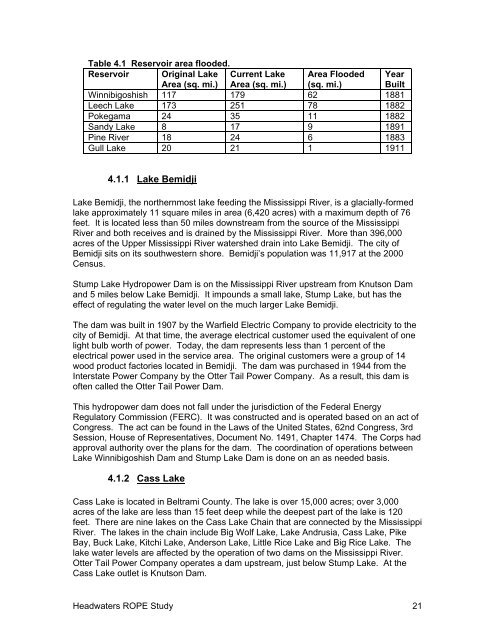
Table 4.1 Reservoir area flooded.Reservoir Original LakeArea (sq. mi.)Current LakeArea (sq. mi.)Area Flooded(sq. mi.)YearBuiltWinnibigoshish 117 179 62 1881Leech Lake 173 251 78 1882Pokegama 24 35 11 1882Sandy Lake 8 17 9 1891Pine River 18 24 6 1883Gull Lake 20 21 1 19114.1.1 Lake BemidjiLake Bemidji, the northernmost lake feeding the Mississippi River, is a glacially-formedlake approximately 11 square miles in area (6,420 acres) with a maximum depth of 76feet. It is located less than 50 miles downstream from the source of the MississippiRiver and both receives and is drained by the Mississippi River. More than 396,000acres of the Upper Mississippi River watershed drain into Lake Bemidji. The city ofBemidji sits on its southwestern shore. Bemidji’s population was 11,917 at the 2000Census.Stump Lake Hydropower Dam is on the Mississippi River upstream from Knutson Damand 5 miles below Lake Bemidji. It impounds a small lake, Stump Lake, but has theeffect of regulating the water level on the much larger Lake Bemidji.The dam was built in 1907 by the Warfield Electric Company to provide electricity to thecity of Bemidji. At that time, the average electrical customer used the equivalent of onelight bulb worth of power. Today, the dam represents less than 1 percent of theelectrical power used in the service area. The original customers were a group of 14wood product factories located in Bemidji. The dam was purchased in 1944 from theInterstate Power Company by the Otter Tail Power Company. As a result, this dam isoften called the Otter Tail Power Dam.This hydropower dam does not fall under the jurisdiction of the Federal EnergyRegulatory Commission (FERC). It was constructed and is operated based on an act ofCongress. The act can be found in the Laws of the United States, 62nd Congress, 3rdSession, House of Representatives, Document No. 1491, <strong>Chapter</strong> 1474. The Corps hadapproval authority over the plans for the dam. The coordination of operations betweenLake Winnibigoshish Dam and Stump Lake Dam is done on an as needed basis.4.1.2 Cass LakeCass Lake is located in Beltrami <strong>County</strong>. The lake is over 15,000 acres; over 3,000acres of the lake are less than 15 feet deep while the deepest part of the lake is 120feet. There are nine lakes on the Cass Lake Chain that are connected by the MississippiRiver. The lakes in the chain include Big Wolf Lake, Lake Andrusia, Cass Lake, PikeBay, Buck Lake, Kitchi Lake, Anderson Lake, Little Rice Lake and Big Rice Lake. Thelake water levels are affected by the operation of two dams on the Mississippi River.Otter Tail Power Company operates a dam upstream, just below Stump Lake. At theCass Lake outlet is Knutson Dam.Headwaters ROPE Study 21