Mud Creek Watershed Restoration Plan - Henderson County Center
Mud Creek Watershed Restoration Plan - Henderson County Center
Mud Creek Watershed Restoration Plan - Henderson County Center

You also want an ePaper? Increase the reach of your titles
YUMPU automatically turns print PDFs into web optimized ePapers that Google loves.
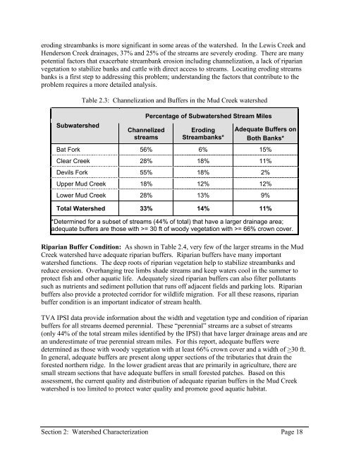
eroding streambanks is more significant in some areas of the watershed. In the Lewis <strong>Creek</strong> and<strong>Henderson</strong> <strong>Creek</strong> drainages, 37% and 25% of the streams are severely eroding. There are manypotential factors that exacerbate streambank erosion including channelization, a lack of riparianvegetation to stabilize banks and cattle with direct access to streams. Locating eroding streamsbanks is a first step to addressing this problem; understanding the factors that contribute to theproblem requires a more detailed analysis.SubwatershedTable 2.3: Channelization and Buffers in the <strong>Mud</strong> <strong>Creek</strong> watershedPercentage of Subwatershed Stream MilesChannelizedstreamsErodingStreambanks*Adequate Buffers onBoth Banks*Bat Fork 56% 6% 15%Clear <strong>Creek</strong> 28% 18% 11%Devils Fork 55% 18% 2%Upper <strong>Mud</strong> <strong>Creek</strong> 18% 12% 12%Lower <strong>Mud</strong> <strong>Creek</strong> 28% 13% 9%Total <strong>Watershed</strong> 33% 14% 11%*Determined for a subset of streams (44% of total) that have a larger drainage area;adequate buffers are those with >= 30 ft of woody vegetation with >= 66% crown cover.Riparian Buffer Condition: As shown in Table 2.4, very few of the larger streams in the <strong>Mud</strong><strong>Creek</strong> watershed have adequate riparian buffers. Riparian buffers have many importantwatershed functions. The deep roots of riparian vegetation help to stabilize streambanks andreduce erosion. Overhanging tree limbs shade streams and keep waters cool in the summer toprotect fish and other aquatic life. Adequately sized riparian buffers can also filter pollutantssuch as nutrients and sediment pollution that runs off adjacent fields and parking lots. Riparianbuffers also provide a protected corridor for wildlife migration. For all these reasons, riparianbuffer condition is an important indicator of stream health.TVA IPSI data provide information about the width and vegetation type and condition of riparianbuffers for all streams deemed perennial. These “perennial” streams are a subset of streams(only 44% of the total stream miles identified by the IPSI) that have larger drainage areas and arean underestimate of true perennial stream miles. For this report, adequate buffers weredetermined as those with woody vegetation with at least 66% crown cover and a width of >30 ft.In general, adequate buffers are present along upper sections of the tributaries that drain theforested northern ridge. In the lower gradient areas that are primarily in agriculture, there aresmall stream sections that have adequate buffers in small forested patches. Based on thisassessment, the current quality and distribution of adequate riparian buffers in the <strong>Mud</strong> <strong>Creek</strong>watershed is too limited to protect water quality and promote good aquatic habitat.Section 2: <strong>Watershed</strong> Characterization Page 18