- Page 1 and 2: Louisville and Jefferson CountyMetr
- Page 4 and 5: Stormwater Management Master PlanGr
- Page 6 and 7: Stormwater Management Master PlanWa
- Page 8 and 9: Stormwater Management Master Plan3.
- Page 10 and 11: Stormwater Management Master Plan9.
- Page 12 and 13: 1.0 PLANNING METHODOLOGY
- Page 14 and 15: Stormwater Management Master PlanTh
- Page 16 and 17: KentonCampbellBooneBallardCarlisleH
- Page 20 and 21: Stormwater Management Master Planco
- Page 22 and 23: Stormwater Management Master PlanTh
- Page 24 and 25: Stormwater Management Master PlanTh
- Page 26 and 27: Stormwater Management Master PlanTa
- Page 28 and 29: Stormwater Management Master PlanGr
- Page 30 and 31: Stormwater Management Master PlanTh
- Page 32 and 33: Stormwater Management Master Plan1.
- Page 34 and 35: Stormwater Management Master Plan2.
- Page 36 and 37: Stormwater Management Master Planpr
- Page 38 and 39: Stormwater Management Master PlanFl
- Page 40 and 41: 3.0 MUDDY FORK BEARGRASS CREEK
- Page 42 and 43: Stormwater Management Master Plando
- Page 44 and 45: Stormwater Management Master PlanA
- Page 46 and 47: 4.0 SOUTH FORK BEARGRASS CREEK
- Page 48 and 49: Stormwater Management Master Plan4.
- Page 50 and 51: Stormwater Management Master Planda
- Page 52 and 53: Stormwater Management Master Plan20
- Page 54 and 55: Stormwater Management Master Plan5.
- Page 56 and 57: Stormwater Management Master Plan5.
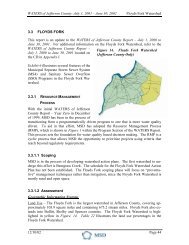
- Page 58 and 59: 6.0 FLOYDS FORK
- Page 60 and 61: Stormwater Management Master PlanEl
- Page 62 and 63: Stormwater Management Master Plan6.
- Page 64 and 65: 7.0 GOOSE CREEK
- Page 66 and 67: Stormwater Management Master PlanEl
- Page 68 and 69:
Stormwater Management Master Planch
- Page 70 and 71:
8.0 HARRODS CREEK
- Page 72 and 73:
Stormwater Management Master PlanEl
- Page 74 and 75:
Stormwater Management Master PlanAs
- Page 76 and 77:
9.0 MILL CREEK
- Page 78 and 79:
Stormwater Management Master Planpu
- Page 80 and 81:
Stormwater Management Master PlanUp
- Page 82 and 83:
Stormwater Management Master PlanFi
- Page 84 and 85:
Stormwater Management Master Plan10
- Page 86 and 87:
Stormwater Management Master PlanCi
- Page 88 and 89:
Stormwater Management Master PlanSm
- Page 90 and 91:
Stormwater Management Master Plan11
- Page 92 and 93:
Stormwater Management Master Planex
- Page 94 and 95:
12.0 POND CREEK
- Page 96 and 97:
Stormwater Management Master Planco
- Page 98 and 99:
Stormwater Management Master PlanIn
- Page 100 and 101:
Stormwater Management Master PlanHy
- Page 102 and 103:
Stormwater Management Master Plan12
- Page 107:
Appendix BFinal Recommended GreenDe
- Page 110 and 111:
Project DRI Phase 1Project List by
- Page 112 and 113:
Project DRI Phase 1Project List by
- Page 114 and 115:
Project DRI Phase 1Project List by
- Page 116 and 117:
Project DRI Phase 1Project List by
- Page 118 and 119:
Project DRI Phase 1Project List by
- Page 120 and 121:
Project DRI Phase 1Project List by
- Page 122 and 123:
Project DRI Phase 1Project List by
- Page 124 and 125:
Project DRI Phase 2Project List by
- Page 126 and 127:
Project DRI Phase 2Project List by
- Page 128 and 129:
Project DRI Phase 2Project List by
- Page 130 and 131:
Project DRI Phase 2Project List by
- Page 132 and 133:
Project DRI Phase 2Project List by
- Page 134 and 135:
Project DRI Phase 3Project List by
- Page 136 and 137:
Project DRI Phase 3Project List by
- Page 138 and 139:
Project DRI Phase 3Project List by
- Page 140 and 141:
Project DRI Phase 3Project List by
- Page 142:
Project DRI Phase 3Project List by