Stormwater Management Master Plan - MSD
Stormwater Management Master Plan - MSD
Stormwater Management Master Plan - MSD

Create successful ePaper yourself
Turn your PDF publications into a flip-book with our unique Google optimized e-Paper software.
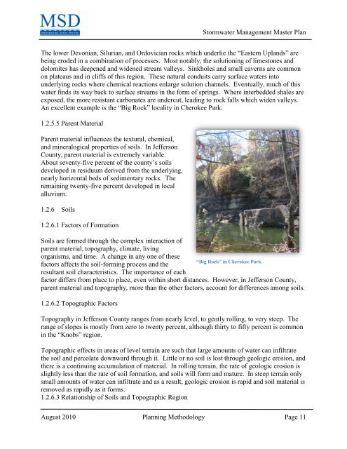
<strong>Stormwater</strong> <strong>Management</strong> <strong>Master</strong> <strong>Plan</strong>The lower Devonian, Silurian, and Ordovician rocks which underlie the “Eastern Uplands” arebeing eroded in a combination of processes. Most notably, the solutioning of limestones anddolomites has deepened and widened stream valleys. Sinkholes and small caverns are commonon plateaus and in cliffs of this region. These natural conduits carry surface waters intounderlying rocks where chemical reactions enlarge solution channels. Eventually, much of thiswater finds its way back to surface streams in the form of springs. Where interbedded shales areexposed, the more resistant carbonates are undercut, leading to rock falls which widen valleys.An excellent example is the “Big Rock” locality in Cherokee Park.1.2.5.5 Parent MaterialParent material influences the textural, chemical,and mineralogical properties of soils. In JeffersonCounty, parent material is extremely variable.About seventy-five percent of the county’s soilsdeveloped in residuum derived from the underlying,nearly horizontal beds of sedimentary rocks. Theremaining twenty-five percent developed in localalluvium.1.2.6 Soils1.2.6.1 Factors of FormationSoils are formed through the complex interaction ofparent material, topography, climate, livingorganisms, and time. A change in any one of these“Big Rock” in Cherokee Parkfactors affects the soil-forming process and theresultant soil characteristics. The importance of eachfactor differs from place to place, even within short distances. However, in Jefferson County,parent material and topography, more than the other factors, account for differences among soils.1.2.6.2 Topographic FactorsTopography in Jefferson County ranges from nearly level, to gently rolling, to very steep. Therange of slopes is mostly from zero to twenty percent, although thirty to fifty percent is commonin the “Knobs” region.Topographic effects in areas of level terrain are such that large amounts of water can infiltratethe soil and percolate downward through it. Little or no soil is lost through geologic erosion, andthere is a continuing accumulation of material. In rolling terrain, the rate of geologic erosion isslightly less than the rate of soil formation, and soils will form and mature. In steep terrain onlysmall amounts of water can infiltrate and as a result, geologic erosion is rapid and soil material isremoved as rapidly as it forms.1.2.6.3 Relationship of Soils and Topographic RegionAugust 2010 <strong>Plan</strong>ning Methodology Page 11