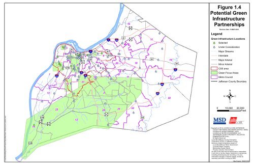
<strong>Stormwater</strong> <strong>Management</strong> <strong>Master</strong> <strong>Plan</strong>The term for the current permit has elapsed, but has been administratively extended by KDOW.<strong>MSD</strong> submitted a proposed <strong>Stormwater</strong> Quality <strong>Management</strong> <strong>Plan</strong> (SWQMP) in 2008 to KDOWfor the permit and is awaiting final approval.The SWQMP, which is planned to be updated once the MS4 permit is finalized, is a detailedbusiness plan <strong>MSD</strong> and its co-permittees intend to use as a tool to implement the MS4 permit.The intended purposed of the SWQMP is to improve water quality in local streams, creeks, andwaterways within Jefferson County. The expected water quality benefits include reductions inpollutants of concern and more closely meeting the Clean Water Act goals for water quality.1.4.3 Integrated Overflow Abatement <strong>Plan</strong> (IOAP)/Green InfrastructureThe IOAP is a long-term plan to improve water quality, control combined sewer overflows(CSOs), and eliminate sanitary sewer overflows (SSOs) throughout the county. The IOAP wasprepared in response to a consent decree with the EPA and the Kentucky Environmental andPublic Protection Cabinet. The IOAP is intended to improve water quality in both the localstreams in Jefferson County and the Ohio River. The expected water quality benefits includereductions in the peak levels of bacteria and a reduction in the amount of time that averagebacteria levels exceed water quality standards. For further information, copies of the IOAP canbe found on <strong>MSD</strong>’s website.As part of the IOAP, 115 potential green infrastructure projects have been identified throughoutthe county as of July 2010. Many types of green projects are being considered, such as bioswales,permeable alleys, pervious parking, and rain gardens. Currently, 20 projects have beenselected for construction and 95 other projects are being considered. A map showing thelocations of these projects is included as Figure 1.4.1.5 Watershed <strong>Master</strong> <strong>Plan</strong>s1.5.1 GeneralThe management of stormwater drainage is recommended to be on a watershed-by-watershedbasis. Accomplishment of this approach shall be through the development of <strong>Stormwater</strong><strong>Management</strong> <strong>Master</strong> <strong>Plan</strong>s. These plans document the hydrologic, physiographic, drainagecharacteristics, and planning tools pertinent to managing stormwater drainage in the watershed.Utilizing this information within the context of various policies, goals and objectives establishedfor the SMMP, specific “Action <strong>Plan</strong>s” set forth recommended regional projects, specialregulations for development, and requirements for further updating and upgrading the planningdata and models.Further information specifically regarding the floodplain of each watershed, including number offloodprone buildings, development trends, critical facilities located in the floodplain, natural andbeneficial functions of the floodplain, and general flooding information can be found in theLouisville Metro Multi-Hazards Mitigation <strong>Plan</strong>.August 2010 <strong>Plan</strong>ning Methodology Page 18
J:\msd\SharedMaps\GreenProjects-StatusMap\Green Infrastructure Locations.mxdPotential GreenInfrastructurePartnerships£¤ 31E22252423popors£¤ 31Wpo13rspors 841 po1416rs 841 Figure 1.4Revision Date: 19-MAY-2010po poLegend£¤ 17§¨¦ §¨¦ rs 71 popopopo Selectedpo popo5popo Under Consideration£¤popopopopopo po popo po7po§¨¦ po popo po po po po po popo popo popo popo£¤ 71 Major Streams£¤ 60 £¤ popo popo po49 £¤popoInterstatepopo popopo £¤ £¤ 150 po 19Major Arterialpo po popors 612618po po 6po£¤ 60Minor Arterialpo £¤ po po po po 8popopoCSS areapopopopopopo§¨¦ 641po3§¨¦§¨¦ poGreen Focus Areas264 po §¨¦ po10po po popo11Metro Councilpo2115 popo §¨¦ 26512 po po2§¨¦ 265popopopo20.£¤ 31WGreen Infrastructure LocationsJefferson County Boundary0 10,000 20,000FeetCopyright (c) 2010, LOUISVILLE AND JEFFERSONCOUNTY METROPOLITAN SEWER DISTRICT (<strong>MSD</strong>),LOUISVILLE WATER COMPANY (LWC),LOUISVILLE METRO GOVERNMENT, andJEFFERSON COUNTY PROPERTY VALUATIONADMINISTRATOR (PVA).All Rights Reserved.Louisville/Jefferson County InformationConsortium (LOJIC), a Jefferson County,Kentucky, based cooperative project of:Louisville/Jefferson Metro GovernmentLouisville Water CompanyMetropolitan Sewer DistrictProperty Valuation AdministratorNo part of this map may be reproduced or transmittedin any form or by any means, electronic or mechanical,including photocopying and recording, or by anyinformation storage or retrieval system, except asexpressly permitted in writing by <strong>MSD</strong>.Map Created: 19-MAY-2010