Stormwater Management Master Plan - MSD
Stormwater Management Master Plan - MSD
Stormwater Management Master Plan - MSD

Create successful ePaper yourself
Turn your PDF publications into a flip-book with our unique Google optimized e-Paper software.
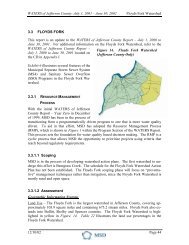
<strong>Stormwater</strong> <strong>Management</strong> <strong>Master</strong> <strong>Plan</strong>4.3 Action <strong>Plan</strong>4.3.1 Watershed RequirementsNew development in the South Fork Beargrass Creek Watershed is required to detain proposedstormwater discharge rates to predeveloped conditions for the 2, 10, and 100 year storm eventsthrough the <strong>MSD</strong> Design Manual. The NRCS Type II, 24 hour rainfall distribution is required tobe used for the modeling. In areas where adequate downstream facilities exist, especially in thelower portion of a watershed where peak flows from the new development will occursubstantially prior to the overall peak of the stream, on a case-by-case basis, <strong>MSD</strong> allowsincreased runoff to be compensated using a regional facility fee. This regional facility fee isused to construct regional basins.New development in the combined sewer area is restricted to a 6-inch stormwater connection tothe combined sewer system to help alleviate the flows in the system during rain events.Engineers must design the new development’s onsite stormwater system to work with the 6-inchoutlet. Examples of this include building detention basins, oversizing onsite stormwater pipes,and using green solutions such as pervious pavement and rain gardens to reduce peak flows andoverall runoff volumes.Floodplain compensation is required in the South Fork Beargrass Creek Watershed at a ratio of1:1 for any fill placed in the fully developed local regulatory floodplain as required in theLouisville Metro Floodplain <strong>Management</strong> Ordinance. This ratio may be increased on a sitespecificbasis as determined by <strong>MSD</strong>.As stated in the Louisville Metro Floodplain <strong>Management</strong> Ordinance, a natural 25 foot buffer oneach side of the stream bank must be preserved on all solid blueline streams as defined by theUSGS 7.5 minute topographic maps. In addition, solid blueline streams may not be relocated,channelized, or stripped, with the exception of public projects such as road crossings, utilities,and detention basins that have no other viable alternative.A minimum buffer is also required by the KDOW through its Kentucky Pollutant DischargeElimination System (KPDES) General Permit For <strong>Stormwater</strong> Discharges Associated WithConstruction Activities (KYR10). A minimum 25 foot buffer is required for discharges towaters categorized as High Quality or Impaired Water (Non-construction related impairment). Aminimum 50 foot buffer is required for discharges to waters categorized as Impaired Waters(Sediment impaired, but no TMDL).In order to promote enhanced water quality and aquatic habitat, natural channel designtechniques are the preferred method for the design of streams. Channel improvement projects inblueline streams are required to use natural or “soft” approaches. <strong>MSD</strong>’s Design Manualoutlines natural channel design requirements in Section 10.3.6.Green infrastructure and post-construction requirements for new development are currentlyunder development and are anticipated to be required as part of the MS4 Permit in lateAugust 2010 South Fork Beargrass Creek Page 5