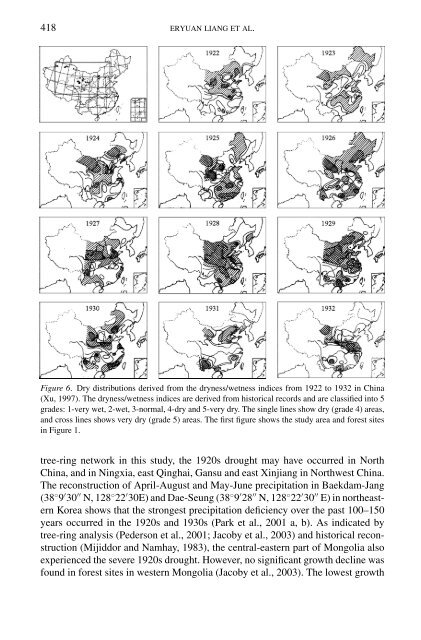
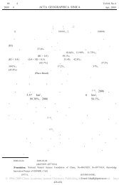
418 ERYUAN LIANG ET AL.Figure 6. Dry distributions derived from the dryness/wetness indices from 1922 to 1932 in China(Xu, 1997). The dryness/wetness indices are derived from historical records and are classified into 5grades: 1-very wet, 2-wet, 3-normal, 4-dry and 5-very dry. The single lines show dry (grade 4) areas,and cross lines shows very dry (grade 5) areas. The first figure shows the study area and forest sitesin Figure 1.tree-ring network in this study, the 1920s drought may have occurred in NorthChina, and in Ningxia, east Qinghai, Gansu and east Xinjiang in Northwest China.The reconstruction of April-August and May-June precipitation in Baekdam-Jang(38 ◦ 9 ′ 30 ′′ N, 128 ◦ 22 ′ 30E) and Dae-Seung (38 ◦ 9 ′ 28 ′′ N, 128 ◦ 22 ′ 30 ′′ E) in northeasternKorea shows that the strongest precipitation deficiency over the past 100–150years occurred in the 1920s and 1930s (Park et al., 2001 a, b). As indicated bytree-ring analysis (Pederson et al., 2001; Jacoby et al., 2003) and historical reconstruction(Mijiddor and Namhay, 1983), the central-eastern part of Mongolia alsoexperienced the severe 1920s drought. However, no significant growth decline wasfound in forest sites in western Mongolia (Jacoby et al., 2003). The lowest growth
<strong>THE</strong> <strong>1920S</strong> <strong>DROUGHT</strong> IN NOR<strong>THE</strong>RN CHINA 419also occurred in 1922 and 1930 in eastern Inner Mongolia (Zhang, 1994; Lianget al., 2003), where the amplitude of tree growth decline was weaker than that inRegion 1. At the XWT stand of Region 1, the number of missing rings is significantlylower than that in other Chinese pine stands, indicating that the drought wasless severe in northern Hebei Province (Li et al., 1994). The XWT stand only hada dryness/wetness index of 4 in 1926, 1928 and 1931 (Figure 6), a milder droughtcondition relative to other stands of Region 1 in the 1920s and early 1930s. Thegrowth decline from 1922 to 1932 is more pronounced at the JGB stand of Region1 (Figure 4). At the BT and HHT stands, the growth decline was significantbeginning in 1926 (Figure 4). Although the HHT and BT stands are close to theJGB stand, the onset of tree growth at these stands capture the spatial variation ofthe 1920s drought (Figure 6). The HS tree-ring series of Region 2 also shows adramatic growth decline in the 1920s, which was the most severe drought (culminatingin 1929) over the 389-yr period, as indicated by a reconstruction of regionalMay–June (Hughes et al., 1994) and April–June precipitation (Figure 7a). The reconstructionof April–June precipitation (1890–1989), based on tree ring densityand stable isotopes in Huangling in central Shaanxi Province, indicated that themost severe drought occurred in the late 1920s in the past 100 years (Liu et al.,1997). Similarly, the May-June precipitation reconstruction using latewood widthsof Chinese pine in the north Helan Mountains also showed a significant droughtinterval in the 1920s (Liu et al., 2004). In the west, Region 3 experienced the severeand sustained drought in the 1920s, as reflected by the dramatic growth decline ofdrought-sensitive trees (Figure 4). In the context of the past 700 years, the lowestmoisture indices in the middle part of Region 3 occurred in the 1920s, which isindicative of dry and warm conditions (Zhang and Wu, 1997) (Figure 7b). The1920s drought was more severe in the eastern part of Region 4, such as HT1, WL3and WL4, compared with DLH1-DLH5 at the western part of Region 4 (Figure7c). However, it is not the most severe drought in the past 200 years in this region.Significant tree growth decline (QML and ZHD) was also observed in Region 5(Figure 7d) (Qin et al., 2003), which was then confirmed with historical records(Chen and Cheng, 1997). The drought was also severe in Region 6 (HM1 andYW1), but weaker in Region 7 (Figure 7e,f). In Regions 4, 6 and 7, few historicalrecords are available to validate the spatial variance of the 1920s drought. Insummary, tree-ring analysis and tree-ring based precipitation reconstructions showthat the 1920s drought was a rare and geographically extensive event. However,more tree-ring sites are needed to fully capture the spatio-temporal occurrence ofthe 1920s drought over northern China.4. Instrumental and Historical Records of the 1920s DroughtA variety of historical records provide a frame of reference for assessing climaticextremes in the 1920s and early 1930s in northern China. The monthly