THE 1920S DROUGHT RECORDED BY TREE RINGS AND ...
THE 1920S DROUGHT RECORDED BY TREE RINGS AND ...
THE 1920S DROUGHT RECORDED BY TREE RINGS AND ...

You also want an ePaper? Increase the reach of your titles
YUMPU automatically turns print PDFs into web optimized ePapers that Google loves.
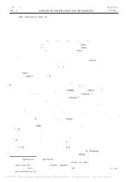
<strong>THE</strong> <strong>1920S</strong> <strong>DROUGHT</strong> IN NOR<strong>THE</strong>RN CHINA 4051930s in Northwest China. Based on dryness/wetness indices in the past 500 yearsin Northwest China, Dong et al. (2000) found that severe droughts, including the1920s drought, usually started in South Ningxia and central Gansu (see Figure 1),and then expanded to Northwest China. The hydrological station in the middlereaches of the Yellow River also showed an 11-yr low-flow period from 1922 to1932 (Shi et al., 1991; Liu and Wu, 1996). In comparison with the 1930s DustBowl in the southern plains of the USA (Worster, 1982; Woodhouse and Overpeck,1998), most studies of the 1920s drought have been based on historical records inChinese and have received scant mention in international journals (Hughes et al.,1994; Fu et al., 1999; Qian and Zhu, 2001; Liang et al., 2003). Recently, severalstudies have also reported that the 1920s drought in northern China was recorded intree rings (Hughes et al., 1994; Zhang and Wu, 1997; Liu and Ma, 1999; Liang et al.,2003; Liu et al., 2004). These studies were, however, limited to a few forest standsin North China. Moreover, most dendrochronological studies in China have beenconfined to climatic reconstructions of a single or just a few tree-ring sites, and todate no large-scale drought or precipitation reconstructions have been completed.The development of a tree-ring network in recent years and the availability ofdocumentation of the well-recorded 1920s drought provide a rare opportunity tocapture the links between the growth of drought-sensitive trees and documentedevidence of drought, and to thus examine the possibility of recovering past largescaledrought events using tree rings.In this study, fourteen tree-ring chronologies, four precipitation and two moistureindex series derived from tree rings in the semi-arid and arid areas of northernChina were selected for analysis. The detailed historical records concerning theeffect of the 1920s drought on agriculture, society, and hydrological systems wereemployed to demonstrate the intensity, duration and spatial extent of the 1920sdrought, allowing for a comparison to be made with drought-related informationderived from a large-scale tree-ring network.2. Study Areas, Climate and Tree-Ring Network2.1. STUDY AREAS <strong>AND</strong> <strong>TREE</strong>-RING NETWORKThe study areas are the semi-arid and arid regions of northern China (Figure 1).Along an east-west orientation, the drought-prone forest sites were selected from theTaihang and Yinshan Mountains in North China (Region 1), the Qinling Mountains(Region 2), the Qilian Mountains (Region 3), the mountains in the east margin ofthe Qaidam Basin (Region 4), the South Qinghai Plateau (Region 5), the east TianshanMountains (Region 6) and the middle-west Tianshan Mountains (Region 7)(Figure 1). The distance between the most eastern forest site (XWT) in Region 1and the most western forest site (ZL) in Region 7 is about 2825 km. Based on administrativedivisions in China, tree-ring sites are situated in six provinces in North