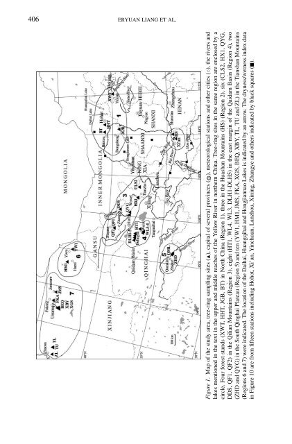
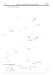
406 ERYUAN LIANG ET AL.Figure 1. Map of the study area, tree-ring sampling sites (), capital of several provinces (◦ ), meteorological stations and other cities (◦), the rivers andlakes mentioned in the text in the upper and middle reaches of the Yellow River in northern China. Tree-ring sites in the same region are enclosed by acircle. Four forest stands (XWT, HHT, JGB, BT) in North China (Region 1), three in the Huashan Mountains (HS) (Region 2), six (CLS2, HX1, QYG,DDS, QF1, QF2) in the Qilian Mountains (Region 3), eight (HT1, WL4, WL3, DLH1-DLH5) in the east margin of the Qaidam Basin (Region 4), two(ZHD and QYG) in the South Qinghai Plateau (Region 5) and ten (YW1, HM1, JMS, FKA, XGS, BEQ, X<strong>BY</strong>, TL, TU and ZL) in the Tianshan Mountains(Regions 6 and 7) were indicated. The location of the Daihai, Huangqihai and Hongjiannao Lakes is indicated by an arrow. The dryness/wetness index datain Figure 10 are from fifteen stations including Hohot, Xi’an, Yinchuan, Lanzhou, Xining, Zhangye and others indicated by black squares ().
<strong>THE</strong> <strong>1920S</strong> <strong>DROUGHT</strong> IN NOR<strong>THE</strong>RN CHINA 407TABLE ISite description and general characteristics of eight new tree-ring width standardized chronologies inthis study. All the chronologies are listed along an east-west direction in northern China. The species(s) include 1, Pinus tabulaeformis; 2,Pinus armandii; 3,Picea crassifolia; 4,Sabina przewalskii.MS, mean sensitivity; CP, calibrating period (years) between tree-ring width chronologies andprecipitation records in the nearby meteorological stations (Figure 4)Chronology Elevation Trees/code S Latitude (N) Longitude (E) m asl Years Cores MS CPXWT 1 39 ◦ 52 ′ 06 ′′ , 114 ◦ 57 ′ 18 ′′ 1600 1888–2002 20/37 0.38 49JGB 1 39 ◦ 29 ′ , 110 ◦ 42 ′ 1347 1850–1998 30/61 0.39 42DDS 3 39 ◦ 02 ′ 54 ′′ , 103 ◦ 48 ′ 42 ′′ 2666 1787–2003 31/92 0.22 53CLS2 1 37 ◦ 26 ′ 41 ′′ , 103 ◦ 41 ′ 25 ′′ 2512 1842–2003 18/54 0.32 52HX1 3 37 ◦ 29 ′ 26 ′′ , 102 ◦ 26 ′ 27 ′′ 2750 1826–2003 30/88 0.17 53HT1 4 37 ◦ 02 ′ 06 ′′ , 98 ◦ 40 ′ 3736 860–2002 12/22 0.37 47QF1 3 39 ◦ 25 ′ 29 ′′ , 98 ◦ 26 ′ 29 ′′ 2783 1816–2003 17/51 0.34 53QF2 4 39 ◦ 25 ′ 18 ′′ , 98 ◦ 26 ′ 10 ′′ 3060 1729–2003 18/52 0.32 53China (Hebei, Inner Mongolia) and Northwest China (Shaanxi, Gansu, Qinghaiand Xinjiang).In Region 1, natural forests have become rare because of long-term humandamage, with the exception of small patches around temples or along steep cliffs(Liang et al., 2003). Four Chinese pine (Pinus tabulaeformis Carr.) forest standsfrom the Xiaowutai Mountain (XWT) on the northwestern edge of the TaihangMountains, Yinshan Mountains (HHT, BT) and Erdos Plateau (JGB) were selectedfor the tree-ring analysis (Figure 1, Table I, II). A standard ring-width chronologyat HHT was taken from Zhang (1994). The BT tree-ring samples were taken byLi et al. (1992) and were re-crossdated later to correct some dating errors (Lianget al., 2003). The JGB and XWT records were developed in this study.Tree ring samples of Huashan pine (Pinus armandii Franch.) were collectedfrom the eastern (HSE), southern (HSS) and western (HSW) peaks of the HuashanMountains (HS) in Region 2 (Figure 1, Table II), and three standard tree-ringchronologies were developed by Shao and Wu (1994).Sixteen forest stands were selected in the northeastern Tibetan Plateau (Regions3–5). In September 2003, five new tree-ring sampling sites were collected from theChanlingshan (CLS2), Haxi (HX1), Dongdashan (DDS), Qifeng (QF1 and QF2)forest centers in Gansu Province in Region 3 (Figure 1, Table I). One Qilian juniper(QYG) tree-ring width chronology in Qilian County of Qinghai Province was developedby Zhang and Wu (1997). In Region 4, eight Qilian juniper (Sabina przewalskiiKom.) forest stands (HT1, WL4, WL3, and DLH1-DLH5) are located in the aridarea (Figure 1, Table II) (Shao et al., 2003, 2005). Several juniper chronologies(WL4, WL3 and DLH1-DLH5) of over 1000 years have been established by Shaoet al. (2003, 2005) and HT1 was developed in this study. In Region 5, two tree-ring