minutes of the 2nd expert appraisal committee (eac ... - eRc India
minutes of the 2nd expert appraisal committee (eac ... - eRc India
minutes of the 2nd expert appraisal committee (eac ... - eRc India

Create successful ePaper yourself
Turn your PDF publications into a flip-book with our unique Google optimized e-Paper software.
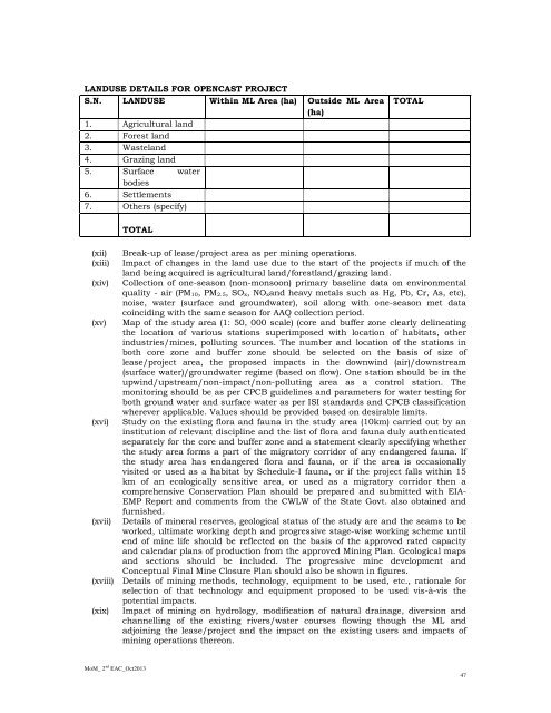
LANDUSE DETAILS FOR OPENCAST PROJECTS.N. LANDUSE Within ML Area (ha) Outside ML Area(ha)1. Agricultural land2. Forest land3. Wasteland4. Grazing land5. Surface waterbodies6. Settlements7. O<strong>the</strong>rs (specify)TOTAL(xii)(xiii)(xiv)(xv)(xvi)(xvii)TOTALBreak-up <strong>of</strong> lease/project area as per mining operations.Impact <strong>of</strong> changes in <strong>the</strong> land use due to <strong>the</strong> start <strong>of</strong> <strong>the</strong> projects if much <strong>of</strong> <strong>the</strong>land being acquired is agricultural land/forestland/grazing land.Collection <strong>of</strong> one-season (non-monsoon) primary baseline data on environmentalquality - air (PM 10, PM 2.5, SO x, NO xand heavy metals such as Hg, Pb, Cr, As, etc),noise, water (surface and groundwater), soil along with one-season met datacoinciding with <strong>the</strong> same season for AAQ collection period.Map <strong>of</strong> <strong>the</strong> study area (1: 50, 000 scale) (core and buffer zone clearly delineating<strong>the</strong> location <strong>of</strong> various stations superimposed with location <strong>of</strong> habitats, o<strong>the</strong>rindustries/mines, polluting sources. The number and location <strong>of</strong> <strong>the</strong> stations inboth core zone and buffer zone should be selected on <strong>the</strong> basis <strong>of</strong> size <strong>of</strong>lease/project area, <strong>the</strong> proposed impacts in <strong>the</strong> downwind (air)/downstream(surface water)/groundwater regime (based on flow). One station should be in <strong>the</strong>upwind/upstream/non-impact/non-polluting area as a control station. Themonitoring should be as per CPCB guidelines and parameters for water testing forboth ground water and surface water as per ISI standards and CPCB classificationwherever applicable. Values should be provided based on desirable limits.Study on <strong>the</strong> existing flora and fauna in <strong>the</strong> study area (10km) carried out by aninstitution <strong>of</strong> relevant discipline and <strong>the</strong> list <strong>of</strong> flora and fauna duly au<strong>the</strong>nticatedseparately for <strong>the</strong> core and buffer zone and a statement clearly specifying whe<strong>the</strong>r<strong>the</strong> study area forms a part <strong>of</strong> <strong>the</strong> migratory corridor <strong>of</strong> any endangered fauna. If<strong>the</strong> study area has endangered flora and fauna, or if <strong>the</strong> area is occasionallyvisited or used as a habitat by Schedule-I fauna, or if <strong>the</strong> project falls within 15km <strong>of</strong> an ecologically sensitive area, or used as a migratory corridor <strong>the</strong>n acomprehensive Conservation Plan should be prepared and submitted with EIA-EMP Report and comments from <strong>the</strong> CWLW <strong>of</strong> <strong>the</strong> State Govt. also obtained andfurnished.Details <strong>of</strong> mineral reserves, geological status <strong>of</strong> <strong>the</strong> study are and <strong>the</strong> seams to beworked, ultimate working depth and progressive stage-wise working scheme untilend <strong>of</strong> mine life should be reflected on <strong>the</strong> basis <strong>of</strong> <strong>the</strong> approved rated capacityand calendar plans <strong>of</strong> production from <strong>the</strong> approved Mining Plan. Geological mapsand sections should be included. The progressive mine development andConceptual Final Mine Closure Plan should also be shown in figures.(xviii) Details <strong>of</strong> mining methods, technology, equipment to be used, etc., rationale forselection <strong>of</strong> that technology and equipment proposed to be used vis-à-vis <strong>the</strong>potential impacts.(xix)Impact <strong>of</strong> mining on hydrology, modification <strong>of</strong> natural drainage, diversion andchannelling <strong>of</strong> <strong>the</strong> existing rivers/water courses flowing though <strong>the</strong> ML andadjoining <strong>the</strong> lease/project and <strong>the</strong> impact on <strong>the</strong> existing users and impacts <strong>of</strong>mining operations <strong>the</strong>reon.MoM_ 2 nd EAC_Oct201347