minutes of the 2nd expert appraisal committee (eac ... - eRc India
minutes of the 2nd expert appraisal committee (eac ... - eRc India
minutes of the 2nd expert appraisal committee (eac ... - eRc India

Create successful ePaper yourself
Turn your PDF publications into a flip-book with our unique Google optimized e-Paper software.
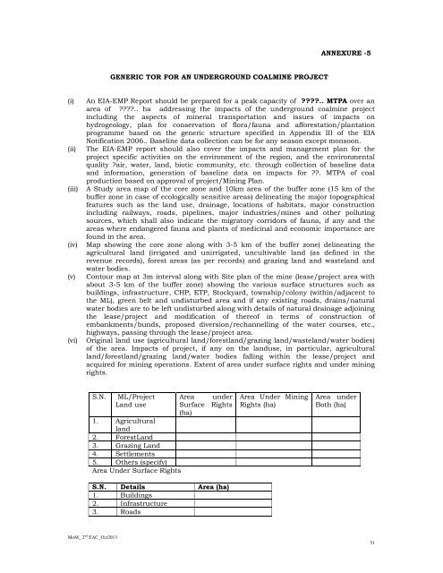
ANNEXURE -5GENERIC TOR FOR AN UNDERGROUND COALMINE PROJECT(i)(ii)(iii)(iv)(v)(vi)An EIA-EMP Report should be prepared for a peak capacity <strong>of</strong> ????.. MTPA over anarea <strong>of</strong> ????.. ha addressing <strong>the</strong> impacts <strong>of</strong> <strong>the</strong> underground coalmine projectincluding <strong>the</strong> aspects <strong>of</strong> mineral transportation and issues <strong>of</strong> impacts onhydrogeology, plan for conservation <strong>of</strong> flora/fauna and afforestation/plantationprogramme based on <strong>the</strong> generic structure specified in Appendix III <strong>of</strong> <strong>the</strong> EIANotification 2006.. Baseline data collection can be for any season except monsoon.The EIA-EMP report should also cover <strong>the</strong> impacts and management plan for <strong>the</strong>project specific activities on <strong>the</strong> environment <strong>of</strong> <strong>the</strong> region, and <strong>the</strong> environmentalquality ?air, water, land, biotic community, etc. through collection <strong>of</strong> baseline dataand information, generation <strong>of</strong> baseline data on impacts for ??. MTPA <strong>of</strong> coalproduction based on approval <strong>of</strong> project/Mining Plan.A Study area map <strong>of</strong> <strong>the</strong> core zone and 10km area <strong>of</strong> <strong>the</strong> buffer zone (15 km <strong>of</strong> <strong>the</strong>buffer zone in case <strong>of</strong> ecologically sensitive areas) delineating <strong>the</strong> major topographicalfeatures such as <strong>the</strong> land use, drainage, locations <strong>of</strong> habitats, major constructionincluding railways, roads, pipelines, major industries/mines and o<strong>the</strong>r pollutingsources, which shall also indicate <strong>the</strong> migratory corridors <strong>of</strong> fauna, if any and <strong>the</strong>areas where endangered fauna and plants <strong>of</strong> medicinal and economic importance arefound in <strong>the</strong> area.Map showing <strong>the</strong> core zone along with 3-5 km <strong>of</strong> <strong>the</strong> buffer zone) delineating <strong>the</strong>agricultural land (irrigated and unirrigated, uncultivable land (as defined in <strong>the</strong>revenue records), forest areas (as per records) and grazing land and wasteland andwater bodies.Contour map at 3m interval along with Site plan <strong>of</strong> <strong>the</strong> mine (lease/project area withabout 3-5 km <strong>of</strong> <strong>the</strong> buffer zone) showing <strong>the</strong> various surface structures such asbuildings, infrastructure, CHP, ETP, Stockyard, township/colony (within/adjacent to<strong>the</strong> ML), green belt and undisturbed area and if any existing roads, drains/naturalwater bodies are to be left undisturbed along with details <strong>of</strong> natural drainage adjoining<strong>the</strong> lease/project and modification <strong>of</strong> <strong>the</strong>re<strong>of</strong> in terms <strong>of</strong> construction <strong>of</strong>embankments/bunds, proposed diversion/rechannelling <strong>of</strong> <strong>the</strong> water courses, etc.,highways, passing through <strong>the</strong> lease/project area.Original land use (agricultural land/forestland/grazing land/wasteland/water bodies)<strong>of</strong> <strong>the</strong> area. Impacts <strong>of</strong> project, if any on <strong>the</strong> landuse, in particular, agriculturalland/forestland/grazing land/water bodies falling within <strong>the</strong> lease/project andacquired for mining operations. Extent <strong>of</strong> area under surface rights and under miningrights.S.N.ML/ProjectLand use1. Agriculturalland2. ForestLand3. Grazing Land4. Settlements5. O<strong>the</strong>rs (specify)Area Under Surface RightsArea underSurface Rights(ha)S.N. Details Area (ha)1. Buildings2. Infrastructure3. RoadsArea Under MiningRights (ha)Area underBoth (ha)MoM_ 2 nd EAC_Oct201351