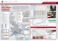
Halcrow, Coastal Studies Forward Programme Data Compilation ...
Halcrow, Coastal Studies Forward Programme Data Compilation ...
Halcrow, Coastal Studies Forward Programme Data Compilation ...

You also want an ePaper? Increase the reach of your titles
YUMPU automatically turns print PDFs into web optimized ePapers that Google loves.
LLWR <strong>Coastal</strong> <strong>Studies</strong>: catalogue of data sources (adapted from <strong>Halcrow</strong> 2003a)Description Date Source Format Copyright Licence Details for InternalReports/Unpub. docsTopographic MappingOS Landline 1:2,500 scale vector data(currently available as MasterMap)OS Superplan 1:10,000 scale rasterdataOS Land-Form Profile 1:10,000 scaledigital height dataOS Panorama 1:50,000 colour rasterdataOS Land-Form Panorama 1:50,000digital height dataCurrent Ordnance Survey Digital Ordnance Survey “Reproduced from OrdnanceSurvey mapping by BNFL bypermission of Ordnance Survey, onbehalf of the Controller of HerMajesty’s Stationery Office. ©Crown Copyright BNFL EL219999. All rights reserved.”Current Ordnance Survey Digital Ordnance SurveyCurrent Ordnance Survey Digital Ordnance SurveyCurrent Ordnance Survey Digital Ordnance Survey “Reproduced from the OrdnanceSurvey map by BNFL bypermission of Ordnance Survey onbehalf of the Controller of HerMajesty’s Stationery Office. ©Crown copyright BNFL EL219999”Current Ordnance Survey Digital Ordnance Survey “Reproduced from the OrdnanceSurvey map by BNFL bypermission of Ordnance Survey onbehalf of the Controller of HerMajesty’s Stationery Office. ©Appendix A 1 of 17