

archaeology
RSGS-The-Geographer-Spring-2015
RSGS-The-Geographer-Spring-2015
- No tags were found...

Create successful ePaper yourself
Turn your PDF publications into a flip-book with our unique Google optimized e-Paper software.
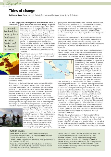
8SPRING 2015Tides of changeDr Richard Bates, Department of Earth & Environmental Sciences, University of St AndrewsFor most geographers, investigation of past sea level is aimed atunderstanding global climate and associated changes in (palaeo)environment, but for archaeologists there is the“…aroundScotland, keyareas of theselandscapesare todayflooded andlost beneaththe waves.”added dimension of trying to understand therelationship between environmental change andpast human activity. The archaeological elementincludes mapping population distribution,interpreting activity in the landscape at any onetime (eg, settlement, specialized sites such asbutchery or resource procurement, hunting,fishing, gathering and later farming, burial, traveland transport) and, across a wider chronologicalframework, quantifying environmental changeand trying to understand the impact on humanbehaviour.At Last Glacial Maximum, the UK was connectedto the continent by a landmass now submergedbeneath the North Sea, andthere is evidence that thislandscape, coined Doggerlandafter the infamous shallowbanks off the Norfolk coast,was made use of by highlymobile Late Glacial huntergatherers.Furthermore, itremained available to the EarlyHolocene population, even with the changes inrelative sea level and improving climate thatfollowed ice retreat.The settlers of the Early Holocene, known today as Mesolithic,were hunter-gatherers who still practised a mobile lifestylethat made sophisticated use of the different ecological nichesavailable to them. Along the coastal margins, they developeda highly specialized maritime culture, using newly developedseagoing technology in order to harvest marine and littoralresources; further inland, a Mesolithic footprint comprisingassemblages of characteristic flaked stone tools has long beenattested along river valleys such as the Tweed and the Dee, and isnow recognised into high upland areas such as the Cairngorms.The lifestyle of these early hunter-gatherers, however, left littleimpact on the environment, and this can pose a problem forarchaeologists trying to find evidence oftheir presence in the palaeolandscapes, aproblem made worse by the fact that aroundScotland, key areas of these landscapes aretoday flooded and lost beneath the waves.To help address the difficult problems ofreconstructing the inundated landscapeand locating archaeological sites, multidisciplinaryresearch teams involvingarchaeologists, geographers, geologists,FURTHER READINGBicket A (2013), Audit of Current State of Knowledge ofSubmerged Palaeolandscapes and sites (Wessex Archaeology:English Heritage Project no 6231)Coles B (1998), Doggerland: a speculative survey (Proceedings ofthe Prehistoric Society, v64)Fraser SM, Knecht R, Milek K, Noble G, Ovenden S, WarrenG, Wickham-Jones CR (2014), Upper Dee Tributaries Project(Discovery and Excavation in Scotland 2013)geophysicists and computer modellers are necessary. One suchteam, comprising members of the Universities of St Andrews,Aberdeen, Dundee, Trinity Wales and Bradford, has beenattempting to reconstruct lost landscapes across Doggerland,in key locations and at different time slices, and to identifyspecific areas of high archaeological potential within that greaterlandscape.The approach follows two paths. Firstly, the palaeolandscapemust be reconstructed; this usually involves a combination ofgeophysical survey followed by direct sampling to gain corematerial to analyse for specific palaeoenvironmental information.Secondly, the inundation history of sea level rise must bemeasured.For the largest areas, data has been re-processed from seismicsurveys donated by the oil and gas industry to show large andcomplex river valley systems, lakes and estuaries leading intohighly convoluted coastlines. Following the regional approach, itis possible to identify focus areas withgreater potential for finding signatures ofhuman activity. Here, surveys in greaterdetail include new seismic sub-bottomsurvey data together with multibeamsonar data for bathymetry in order toidentify the submerged land surfaces.In Scotland, a programme of researchhas targeted areas around the Orkneyarchipelago. These areas were chosenbecause of their great abundance oflater <strong>archaeology</strong>, in particular from the period immediatelypost-dating the Mesolithic – the Neolithic, when agriculture wasfirst developed in the islands. In Orkney, the record of this timeis exceptionally complete and comprises settlements (suchas Skara Brae), tombs and ritual sites, including the complexof ceremonial monuments at the Heart of Neolithic Orkney(the stone circles of Brodgar and Stenness, and the tomb ofMaeshowe, all assigned World Heritage status). Today thiscomplex is sited in a notable location along the thin isthmus ofland that lies between the waters of the Lochs of Stenness andHarray. Our work has shown a very different picture at the timeof occupation, however. The geophysics, palaeoenvironmentalinformation and sea level record all indicate a true ‘landscape’of gently undulating land, with restricted stretches of freshwater,and marshland that was gradually flooded long after themonuments were built.What did the early farmers make of the inundation of thissacred landscape? How did they react to the changes in resourcelocations around the islands as the relative sea level reachedpresent height? We will never know exactly, but only by recreatingthe lost lands can we start to consider their reactions – reactionsthat have a definite resonance to our own concerns today and intothe future.Gaffney V, Fitch S, Smith D (2009), Europe’s Lost World, TheRediscovery of Doggerland (CBA Research Report 160)Wickham-Jones CR (2014), Prehistoric hunter-gathererinnovations: coastal adaptions. In Cummings V, Jordan P,Zvelebil M (eds), The Oxford Handbook of the Archaeology andAnthropology of Hunter-gatherers (Oxford University Press)ScARF, Scottish Archaeological Research Framework (www.scottishheritagehub.com)