

archaeology
RSGS-The-Geographer-Spring-2015
RSGS-The-Geographer-Spring-2015
- No tags were found...

You also want an ePaper? Increase the reach of your titles
YUMPU automatically turns print PDFs into web optimized ePapers that Google loves.
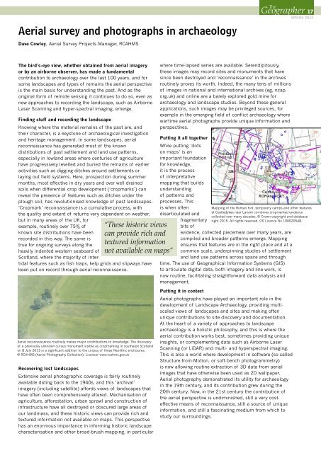
Aerial survey and photographs in <strong>archaeology</strong>Dave Cowley, Aerial Survey Projects Manager, RCAHMSTheGeographer 14- 17SPRING 2015The bird’s-eye view, whether obtained from aerial imageryor by an airborne observer, has made a fundamentalcontribution to <strong>archaeology</strong> over the last 100 years, and forsome landscapes and types of remains the aerial perspectiveis the main basis for understanding the past. And as theoriginal form of remote sensing it continues to do so, even asnew approaches to recording the landscape, such as AirborneLaser Scanning and hyper-spectral imaging, emerge.Finding stuff and recording the landscapeKnowing where the material remains of the past are, andtheir character, is a keystone of archaeological investigationand heritage management. In some landscapes, aerialreconnaissance has generated most of the knowndistributions of past settlement and land use patterns,especially in lowland areas where centuries of agriculturehave progressively levelled and buried the remains of earlieractivities such as digging ditches around settlements orlaying out field systems. Here, prospection during summermonths, most effective in dry years and over well-drainedsoils when differential crop development (‘cropmarks’) canreveal the presence of features such as ditches under theplough soil, has revolutionised knowledge of past landscapes.‘Cropmark’ reconnaissance is a cumulative process, withthe quality and extent of returns very dependent on weather,but in many areas of the UK, forexample, routinely over 75% ofknown site distributions have beenrecorded in this way. The same istrue for ongoing surveys along theheavily indented western seaboard ofScotland, where the majority of intertidalfeatures such as fish traps, kelp grids and slipways havebeen put on record through aerial reconnaissance.“These historic viewscan provide rich andtextured informationnot available on maps”where time-lapsed series are available. Serendipitously,these images may record sites and monuments that havesince been destroyed and ‘reconnaissance’ in the archivesroutinely proves its worth. Indeed, the many tens of millionsof images in national and international archives (eg, ncap.org.uk) and online are a barely explored gold mine for<strong>archaeology</strong> and landscape studies. Beyond these generalapplications, such images may be privileged sources, forexample in the emerging field of conflict <strong>archaeology</strong> wherewartime aerial photographs provide unique information andperspectives.Putting it all togetherWhile putting ‘dotson maps’ is animportant foundationfor knowledge,it is the processof interpretativemapping that buildsunderstandingof patterns andprocesses. Thisis when oftendisarticulated andfragmentarybits ofevidence, collected piecemeal over many years, arecompiled and broader patterns emerge. Mappingensures that features are in the right place and at acommon scale, underpinning studies of settlementand land use patterns across space and throughtime. The use of Geographical Information Systems (GIS)to articulate digital data, both imagery and line work, isnow routine, facilitating straightforward data analysis andmanagement.Mapping of the Roman fort, temporary camps and other featuresat Castledykes near Lanark combines cropmarked evidencecollected over many decades. © Crown copyright and databaseright 2015. All rights reserved. OS Licence No 100020548.Aerial reconnaissance routinely makes major contributions to knowledge. The discoveryof a previously unknown cursus monument visible as cropmarking in southeast Scotlandon 8 July 2013 is a significant addition to the corpus of these Neolithic enclosures.© RCAHMS (Aerial Photography Collection). Licensor www.rcahms.gov.ukRecovering lost landscapesExtensive aerial photographic coverage is fairly routinelyavailable dating back to the 1940s, and this ‘archival’imagery (including satellite) affords views of landscapes thathave often been comprehensively altered. Mechanisation ofagriculture, afforestation, urban sprawl and construction ofinfrastructure have all destroyed or obscured large areas ofour landmass, and these historic views can provide rich andtextured information not available on maps. This perspectivehas an enormous importance in informing historic landscapecharacterisation and other broad-brush mapping, in particularPutting it in contextAerial photographs have played an important role in thedevelopment of Landscape Archaeology, providing multiscaledviews of landscapes and sites and making oftenunique contributions to site discovery and documentation.At the heart of a variety of approaches to landscape<strong>archaeology</strong> is a holistic philosophy, and this is where theaerial contribution works best, sometimes providing uniqueinsights, or complementing data such as Airborne LaserScanning (or LiDAR) and multi- and hyperspectral imaging.This is also a world where development in software (so-calledStructure-from-Motion, or soft-bench photogrammetry)is now allowing routine extraction of 3D data from aerialimages that have otherwise been used as 2D wallpaper.Aerial photography demonstrated its utility for <strong>archaeology</strong>in the 19th century, and its contribution grew during the20th century. Now, in the 21st century the contribution ofthe aerial perspective is undiminished, still a very costeffectivemeans of reconnaissance, still a source of uniqueinformation, and still a fascinating medium from which tostudy our surroundings.