

archaeology
RSGS-The-Geographer-Spring-2015
RSGS-The-Geographer-Spring-2015
- No tags were found...

You also want an ePaper? Increase the reach of your titles
YUMPU automatically turns print PDFs into web optimized ePapers that Google loves.
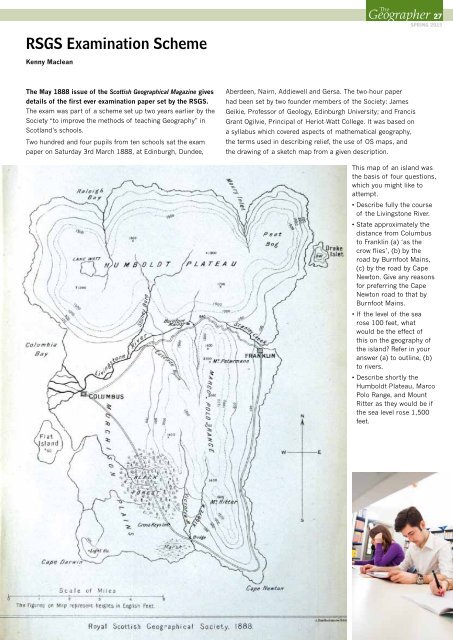
RSGS Examination SchemeKenny MacleanTheGeographer 14- 27SPRING 2015The May 1888 issue of the Scottish Geographical Magazine givesdetails of the first ever examination paper set by the RSGS.The exam was part of a scheme set up two years earlier by theSociety “to improve the methods of teaching Geography” inScotland’s schools.Two hundred and four pupils from ten schools sat the exampaper on Saturday 3rd March 1888, at Edinburgh, Dundee,Aberdeen, Nairn, Addiewell and Gersa. The two-hour paperhad been set by two founder members of the Society: JamesGeikie, Professor of Geology, Edinburgh University; and FrancisGrant Ogilvie, Principal of Heriot-Watt College. It was based ona syllabus which covered aspects of mathematical geography,the terms used in describing relief, the use of OS maps, andthe drawing of a sketch map from a given description.This map of an island wasthe basis of four questions,which you might like toattempt.• Describe fully the courseof the Livingstone River.• State approximately thedistance from Columbusto Franklin (a) ‘as thecrow flies’, (b) by theroad by Burnfoot Mains,(c) by the road by CapeNewton. Give any reasonsfor preferring the CapeNewton road to that byBurnfoot Mains.• If the level of the searose 100 feet, whatwould be the effect ofthis on the geography ofthe island? Refer in youranswer (a) to outline, (b)to rivers.• Describe shortly theHumboldt Plateau, MarcoPolo Range, and MountRitter as they would be ifthe sea level rose 1,500feet.