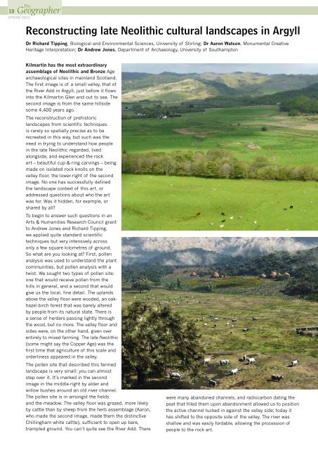
18SPRING 2015Reconstructing late Neolithic cultural landscapes in ArgyllDr Richard Tipping, Biological and Environmental Sciences, University of Stirling; Dr Aaron Watson, Monumental CreativeHeritage Interpretation; Dr Andrew Jones, Department of Archaeology, University of SouthamptonKilmartin has the most extraordinaryassemblage of Neolithic and Bronze Agearchaeological sites in mainland Scotland.The first image is of a small valley, that ofthe River Add in Argyll, just before it flowsinto the Kilmartin Glen and out to sea. Thesecond image is from the same hillsidesome 4,400 years ago.The reconstruction of prehistoriclandscapes from scientific techniquesis rarely so spatially precise as to berecreated in this way, but such was theneed in trying to understand how peoplein the late Neolithic regarded, livedalongside, and experienced the rockart – beautiful cup-&-ring carvings – beingmade on isolated rock knolls on thevalley floor, the lower-right of the secondimage. No-one has successfully definedthe landscape context of this art, oraddressed questions about who the artwas for. Was it hidden, for example, orshared by all?To begin to answer such questions in anArts & Humanities Research Council grantto Andrew Jones and Richard Tipping,we applied quite standard scientifictechniques but very intensively acrossonly a few square kilometres of ground.So what are you looking at? First, pollenanalysis was used to understand the plantcommunities, but pollen analysis with atwist. We sought two types of pollen site:one that would receive pollen from thehills in general, and a second that wouldgive us the local, fine detail. The uplandsabove the valley floor were wooded, an oakhazel-birchforest that was barely alteredby people from its natural state. There isa sense of herders passing lightly throughthe wood, but no more. The valley floor andsides were, on the other hand, given overentirely to mixed farming. The late Neolithic(some might say the Copper Age) was thefirst time that agriculture of this scale andorderliness appeared in the valley.The pollen site that described this farmedlandscape is very small: you can almoststep over it. It’s marked in the secondimage in the middle-right by alder andwillow bushes around an old river channel.The pollen site is in amongst the fieldsand the meadow. The valley floor was grazed, more likelyby cattle than by sheep from the herb assemblage (Aaron,who made the second image, made them the distinctiveChillingham white cattle), sufficient to open up bare,trampled ground. You can’t quite see the River Add. Therewere many abandoned channels, and radiocarbon dating thepeat that filled them upon abandonment allowed us to positionthe active channel tucked in against the valley side; today ithas shifted to the opposite side of the valley. The river wasshallow and was easily fordable, allowing the procession ofpeople to the rock art.
Society of Antiquariesof ScotlandTheGeographer 14- 19SPRING 2015At around 2400 BC the river was beginningto flood more frequently: overbank sandsare recorded in the peat of the abandonedchannel on the valley floor. This may havebeen a response to changing climate,but may also have been because the riverbegan to receive lots of sediment fromthe valley sides. The lower slopes in thevalley are glacio-fluvial terraces, level ontheir formation but by the late Neolithicmuch degraded. In the second image thesesurfaces have classic round-houses on them.These are a conceit. We didn’t find these,one reason being, perhaps, that traces ofthem were lost by soil erosion. We recordeda metre or two of colluvial sediment in threetransects of boreholes running up this slope,inter-bedded between in situ peat, whichwe couldradiocarbondate. Thisis probablythe bestlong-termrecord of soilerosion in“There is a senseof herders passinglightly through thewood, but no more.”Scotland, and the late Neolithic is one periodof major erosion in the valley. We knewfrom our pollen analyses that farmers weregrowing wheat and probably barley, but wedon’t know where the fields were. We placedthem on this slope, first because the valleyfloor was frequently flooded at this time,and second because we had to explain theamount of soil erosion. However, move tothe right of the last round-houses and you’llsee deep gullies being ripped into an alluvialfan, itself inter-bedded with peat, whichoriginates above the lower slope. Maybeincreasing rainfall was starting to aggravatewhat damage farmers made.So: all this to understand that rock art herein the Add Valley was made in full view offarming communities who walked past itevery day. The acts of carving may have beenspecial occasions, but the art belonged toeveryone.FURTHER READINGJones AM, Freedman D, O’Connor B, Lamdin-Whymark H,Tipping R, Watson A (2011), An Animate Landscape: Rock Artand the Prehistory of Kilmartin, Argyll, Scotland (Macclesfield:Windgather Press)Vina OberlanderFounded in 1780 to study the antiquities and history of Scotland,the Society has provided a forum for debate, discussion and sharingof knowledge. Many of the key objects in the National MuseumsScotland were collected by our members (called Fellows) duringthe 18th and 19th centuries. Today, the Society continues to be animportant player in Scotland’s heritage sector.The Society:• promotes lectures by leading researchers;• publishes current research and books covering all periods ofScotland’s history;• supports archaeological and historical research through grantsand prizes;• responds to Government and other consultations with relevance tothe historic environment of Scotland;• presents regional and international conferences;• delivers initiatives like Dig It! 2015 (see below), and ScARF (ScottishArchaeological Research Framework), a collaboration bringingtogether experts to provide an overview of research in Scotland.Our Fellows (nearly 3,000 worldwide) are a diverse group of people withone common passion – the past. They might be emerging researchers,established academics, heritage experts, or talented lay people with adeep interest in Scotland’s history. See www.socantscot.org for moreinformation.Dig It! 2015Julianne McGrawDig It! 2015, the yearlongcelebration ofScottish <strong>archaeology</strong>, isencouraging everyoneto discover Scotland’sstories! Over a hundredevents are available onthe website, rangingfrom Iron Age cookingand Land Rover safaristo Pictish lecturesand internationalconferences. TheseTraditional <strong>archaeology</strong> is an important part of the Dig It!2015 programme, with lots of opportunities to get involved.© Stuart Vanceevents are happening throughout Scotland and most are free orinexpensive, and open to everyone. Hundreds more will be addedthroughout the year, so keep checking back in!Dig It! 2015 have also been busy promoting collaboration acrossand beyond the sector, leading to some very exciting projects. Apartnership with Immersive Minds, for example, will result in thecreation of an <strong>archaeology</strong>-packed, digital Scotland within the populargame of Minecraft. An upcoming art competition, in partnership withForestry Commission Scotland, will invite members of the public,and professionals, to help us visualise Scotland’sstunning <strong>archaeology</strong>.Visit our website or sign up for our e-newsletter(www.digit2015.com/contact-us) which includesupcoming events, volunteer opportunities, exclusiveproject news and more!