The Rambler
Aug - Wasatch Mountain Club
Aug - Wasatch Mountain Club

Create successful ePaper yourself
Turn your PDF publications into a flip-book with our unique Google optimized e-Paper software.
FAINT TRAILS IN THE WASATCH<br />
43. Twin Lakes - Lake Mary Trail<br />
Researching the origin and development of trails can be much like researching a family history. <strong>The</strong><br />
problem with the trails is that there is nothing like a Trails History center or a library where one could search for<br />
something like “Twin Lakes to Lake Mary trail.” <strong>The</strong> alternative is to survey what might be available in the form<br />
of written accounts of an area and the activities that might have taken place there and merging that with what few<br />
old maps that might be available. In the case of the trail in question here, what is known is that originally it was<br />
two separate and distinct trails that served their individual purposes, and later were joined to serve a new and<br />
completely different purpose.<br />
<strong>The</strong> Twin Lakes - Lake Mary trail may<br />
not be as well known or as popular as others<br />
in the Brighton area, such as the Twin Lakes,<br />
Twin Lakes Pass or Lake Mary trails, but it<br />
is a wonderful trail that runs along the base<br />
of Mount Millicent, going through a dense<br />
forest as well as an open boulder field. Its<br />
route as it appears today is shown in Figure<br />
1, but that was not its original route. <strong>The</strong><br />
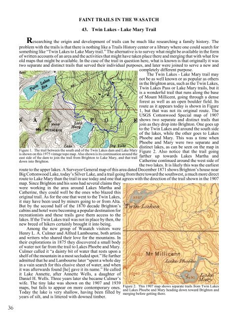
USGS Cottonwood Special map of 1907<br />
shows two separate and distinct trails that<br />
join as they drop into Brighton. One goes up<br />
to the Twin Lakes and around the south side<br />
of the lakes, while the other goes to Lakes<br />
Phoebe and Mary. This was a time when<br />
Phoebe and Mary were two separate and<br />
Figure 1. <strong>The</strong> trail between the south end of the Twin Lakes dam and Lake Mary<br />
is shown on this 1975 vintage topo map. Also shown is its continuation around the<br />
east side of the dam to join the trail from Brighton to Lake Mary, and that trail<br />
down into Brighton.<br />
distinct lakes, as can be seen on the map in<br />
Figure 2. Also notice that the trail going<br />
farther up towards Lakes Martha and<br />
Catherine continued around the west side of<br />
the two lakes. It is likely this was the earliest<br />
route to the upper lakes. A Surveyor General map of this area dated December 1871 shows Brighton’s house near<br />
Big Cottonwood Lake, today’s Silver Lake, and a trail going from there toward the southwest, a much more direct<br />
route to Lake Mary than the trail in use today and one that agrees with the direction of the trail shown in the 1907<br />
map. Since Brighton and his sons had several claims they<br />
were working in the area around Lakes Martha and<br />
Catherine, they could well be the ones who blazed this<br />
original trail. As for the one that went to the Twin Lakes,<br />
it may have been used by miners going to or from Alta.<br />
But by the second half of the 1870 decade Brighton’s<br />
cabins and hotel were becoming a popular destination for<br />
recreationists and these trails gave them access to the<br />
lakes. If the Twin Lakes trail was not in place by then, the<br />
new breed of hikers certainly brought it into being.<br />
Among the new group of Wasatch visitors were<br />
Henry L. A. Culmer and Alfred Lambourne, both artists<br />
and writers who shared their love for the mountains. In<br />
their explorations in 1875 they discovered a small body<br />
of water not far from the trail to Lakes Phoebe and Mary.<br />
Culmer called it “a dainty bit of water that rests upon a<br />
shelf of the mountain in a most secluded spot.” He further<br />
admitted that he and Lambourne later “spent a whole day<br />
in a vain search for this elusive sheet of water, and when<br />
it was afterwards found [he] gave it its name.” He called<br />
it Lake Annette, after Annette Wells, a daughter of<br />
Daniel H. Wells. Three years later she became Culmer’s<br />
wife. <strong>The</strong> tiny lake was shown on the 1907 and 1939<br />
maps, but fails to appear on more contemporary ones.<br />
Today the lake is very shallow, having been filled by<br />
years of silt, and is littered with downed timber.<br />
Figure 2. This 1907 map shows separate trails from Twin Lakes<br />
and Lakes Phoebe and Mary heading down toward Brighton and<br />
merging before getting there.<br />
36