Rambler
September 2010 - Wasatch Mountain Club
September 2010 - Wasatch Mountain Club
- No tags were found...

You also want an ePaper? Increase the reach of your titles
YUMPU automatically turns print PDFs into web optimized ePapers that Google loves.
FAINt tRAILS IN thE wASAtCh<br />
44. Mountain Lake Mine and Road<br />
In the spring and early summer of 1870 William S. Brighton and Joseph B. Elder went prospecting in the<br />
upper reaches of Big Cottonwood Canyon and filed four claims together before going their separate ways. Two<br />
of the claims were given names that were destined to survive and be used by important mining operations at the<br />
head of the canyon. The first was the Great Western. While the claim<br />
was not extensively worked, the name was salvaged and used for a<br />
series of mining companies that ultimately controlled about 1700<br />
acres of mining land in Big Cottonwood and Snake Creek Canyons.<br />
Brighton and Elder’s fourth claim was called Mountain Lake,<br />
situated on the ridge between Dog Lake and Lake Catherine at the<br />
head of the canyon. For this claim Brighton included the names of his<br />
wife, Catherine, and three sons, Robert, William and Thomas.<br />
Through the years that followed the oldest son, Robert A., worked this<br />
and later adjacent claims continually with but indifferent success. He<br />
also worked in some Park City mines and convinced a few influential<br />
men there that Big Cottonwood held considerable promise. In 1892 he<br />
was instrumental in forming the Mountain Lake Mining Company.<br />
Principals in this venture included his parents, three brothers and ten<br />
men from Salt Lake City and Park City. Several of the latter were well<br />
known to everyone in Park City at that time, and their names are still<br />
well known on South Temple street in Salt Lake City. But it was<br />
Robert Brighton who stayed in the mountains to work the mine,<br />
summer and winter. On occasion he was reported to have crossed the<br />
mountain to Park City on snowshoes so he could take the train to Salt<br />
Lake City to visit his family. He concentrated his efforts in driving a<br />
tunnel penetrating the slope below the claims to develop them at<br />
depth. Known then as the Magnet tunnel since it was on the Magnet<br />
claim, it had considerable length, over 550 feet when the claim was<br />
surveyed in 1898. It continued to be used well into the twentieth<br />
century and left a very prominent dump of light gray rock.<br />
It was during these years the road that is the subject of this article<br />
was put in place. It ran due south from the Brighton community about<br />
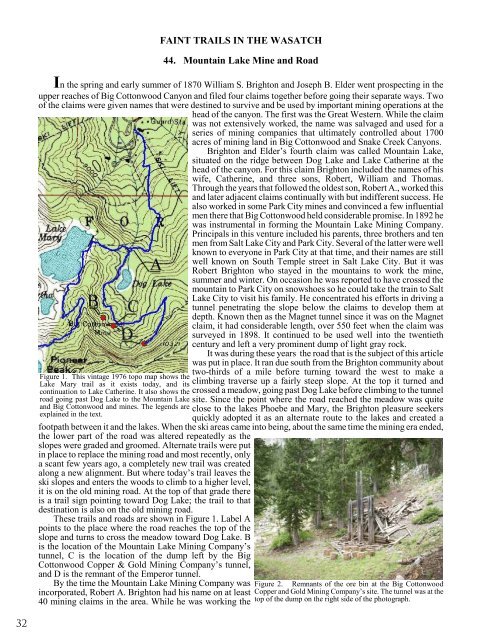
Figure 1. This vintage 1976 topo map shows the<br />
Lake Mary trail as it exists today, and its<br />
continuation to Lake Catherine. It also shows the<br />
road going past Dog Lake to the Mountain Lake<br />
and Big Cottonwood and mines. The legends are<br />
explained in the text.<br />
two-thirds of a mile before turning toward the west to make a<br />
climbing traverse up a fairly steep slope. At the top it turned and<br />
crossed a meadow, going past Dog Lake before climbing to the tunnel<br />
site. Since the point where the road reached the meadow was quite<br />
close to the lakes Phoebe and Mary, the Brighton pleasure seekers<br />
quickly adopted it as an alternate route to the lakes and created a<br />
footpath between it and the lakes. When the ski areas came into being, about the same time the mining era ended,<br />
the lower part of the road was altered repeatedly as the<br />
slopes were graded and groomed. Alternate trails were put<br />
in place to replace the mining road and most recently, only<br />
a scant few years ago, a completely new trail was created<br />
along a new alignment. But where today’s trail leaves the<br />
ski slopes and enters the woods to climb to a higher level,<br />
it is on the old mining road. At the top of that grade there<br />
is a trail sign pointing toward Dog Lake; the trail to that<br />
destination is also on the old mining road.<br />
These trails and roads are shown in Figure 1. Label A<br />
points to the place where the road reaches the top of the<br />
slope and turns to cross the meadow toward Dog Lake. B<br />
is the location of the Mountain Lake Mining Company’s<br />
tunnel, C is the location of the dump left by the Big<br />
Cottonwood Copper & Gold Mining Company’s tunnel,<br />
and D is the remnant of the Emperor tunnel.<br />
By the time the Mountain Lake Mining Company was<br />
incorporated, Robert A. Brighton had his name on at least<br />
40 mining claims in the area. While he was working the<br />
Figure 2. Remnants of the ore bin at the Big Cottonwood<br />
Copper and Gold Mining Company’s site. The tunnel was at the<br />
top of the dump on the right side of the photograph.<br />
32