Rambler
Nov - Wasatch Mountain Club
Nov - Wasatch Mountain Club
- No tags were found...

You also want an ePaper? Increase the reach of your titles
YUMPU automatically turns print PDFs into web optimized ePapers that Google loves.
FAINT TRAILS IN THE WASATCH<br />
28. Henry F. Samson and the Samson Mine<br />
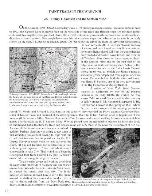
On the current (1998) USGS Dromedary Peak 7-1/2 minute quadrangle and all previous editions back<br />
to 1903, the Samson Mine is shown high on the west side of the Reed and Benson ridge. On the most recent<br />
edition of this map the entire patented claim, 200 x 1500 feet, running in a north-northwest and south-southeast<br />
direction is shown as well. Few people have seen this mine and some question whether its location is correctly<br />
shown on the map. It is, but being situated about 100 feet below the top of the ridge on very steep slopes above<br />
the near-vertical cliffs, it is neither obvious nor easy<br />
of access, and once found has very little remaining<br />
save some light colored soil from the dump that has<br />
been eroded and washed down toward and over the<br />
cliffs below. Also shown on these maps, northeast<br />
of the Samson mine and on the east side of the<br />
ridge, is an unidentified mining shaft. Actually, this<br />
was a tunnel known as the Saint Louis Tunnel,<br />
whose intent was to exploit the Samson mine at<br />
somewhat greater depth and from a point of easier<br />
access. The man behind both the mine and tunnel<br />
was Henry F. Samson, one of the very early miners<br />
in the Big Cottonwood Mining District.<br />
A native of New York State, Samson<br />
This map, from the 1955 USGS Dromedary Peak quadrangle, shows<br />
the Samson Mine near the top of the Reed and Benson ridge, between<br />
the South Fork and Days Fork. The dashed line indicates the<br />
approximate route of the trail from the Days Fork road to the St.<br />
Louis tunnel, which was used to develop the Samson Mine.<br />
traveled to California by way of the Panama<br />
Isthmus in the early 1860s. He worked his way<br />
across California and Nevada and, in the company<br />
of fellow miner S. M. Hammond, appeared in Big<br />
Cottonwood Canyon in the Spring of 1871, where<br />
the two men prospected for mining promoters<br />
Joseph W. Meeks and Richard R. Hawkins. In this capacity they recorded the Provo claim at Carbonate Pass,<br />
south of Kessler Peak, and did most of the development at that site. In fact, Samson acted as Supervisor of that<br />
mine until the venture failed. Samson then went off on his own and started working his own claim, which he<br />
named after himself: the H. F. Samson Mine. Why he picked such an inaccessible location for his claim could<br />
be questioned, but at that time the Reed and Benson mine was very much in the news for its shipment of rich ore.<br />
As a result the immediate area became a hotbed of<br />
activity. Perhaps Samson was trying to tap some of<br />
that desirable ore without having to cope with the<br />
crowd. But isolation has its penalties. As the U.S.<br />
Deputy Surveyor noted when he later surveyed the<br />
claim, “It has not facilities for constructing a road<br />
without great expense ...,” but did admit a trail<br />
connected it to Alta City. That would have been the<br />
Goodspeed trail from Central City plus Samson’s<br />
own crude trail along the ridge to his mine.<br />
To gain easier access and working conditions<br />
he went to the other side of the ridge and established<br />
a tunnel site. When he found investors in Saint Louis,<br />
he named the tunnel after that city. The initial<br />
infusion of capital allowed him to drive the tunnel<br />
toward the shaft at his claim and to build a road, or<br />
trail to the tunnel site from the Days Fork road,<br />
nearly one thousand feet below. It was later described<br />
Site of the Samson Mine on the steep west slopes of the Reed and<br />
Benson ridge. Little remains except for light colored soil that has<br />
been washed down the slopes below.<br />
12