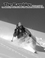
Rambler
Nov - Wasatch Mountain Club
Nov - Wasatch Mountain Club
- No tags were found...

Create successful ePaper yourself
Turn your PDF publications into a flip-book with our unique Google optimized e-Paper software.
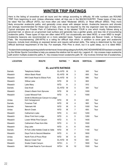
WINTER TRIP RATINGS<br />
Here is the listing of snowshoe and ski tours and the ratings according to difficulty. All mile numbers are ROUND<br />
TRIP, from beginning to end. Unless otherwise noted, all trips are in the BACKCOUNTRY. These types of trips may<br />
be rated ‘Not too difficult’ (NTD), but more often are rated ‘Moderate’ (MOD), or ‘Most difficult’ (MSD). They more<br />
likely encounter avalanche paths, and generally cross areas with steeper terrain. Avalanche beacons and shovels<br />
are strongly recommended for these type of trips, and may be required by the trip organizer (see trip descriptions).<br />
Typical examples are Powder Park of Catherine’s Pass. A trip labeled TOUR is one which mostly follows along a<br />
groomed trail, or above an un-groomed road surface and generally has a gentler grade, and less risk of encountering<br />
avalanche paths. These types of trips are often rated NTD, but occasionally are rated MOD, or even MSD to length.<br />
Avalanche beacons are recommended on a more selected basis. Typical examples are Beaver Creek, or Norway<br />
Flats. ‘Ski mountaineering’ (SKI-MTN) is a rating for difficult trips which, in addition to snow gear and avalanche<br />
beacons, include boot climbing on exposed terrain and require self-arrest skills. The rating is determined by the most<br />
difficult technical requirement of the trip. For example, Pink Pine is short, but it is quite steep, so it is rated MSD.<br />
* Avalanche knowledge is a prerequisite for winter travel. A new rating category for AVALANCHE AWARENESS has been compiled<br />
by the Winter Sports Committee to help you assess the relative risk for each trip. Legend- A! - trip crosses major avalanche<br />
path and/or multiple avalanche paths; A - trip crosses known avalanche path; M - trip involves minimal risk of avalanches.<br />
LOCATION ROUTE RATING * MILES VERTICAL COMMENT<br />
EL and NTD RATINGS<br />
Daniels Telephone Hollow EL-NTD M 3 300 Tour<br />
Wasatch Albion Basin Road EL-NTD M 3 600 Tour<br />
Wasatch Mill Creek Road to Elbow Fork EL-NTD M 3 680 Tour<br />
Wasatch Willow Lake NTD M 3 800<br />
Wasatch Lake Mary NTD A 3 910<br />
Daniels Doe Knoll EL-NTD M 5 300 Tour<br />
Wasatch Green’s Basin from Spruces NTD M 4 1000<br />
Wasatch Lower Mineral Fork NTD A 4 1000<br />
Uintas<br />
Smith & Morehouse Canyon to Ledgefork<br />
Campground NTD M 6 400 Tour<br />
Daniels Foreman Trail NTD M 4 900 Tour<br />
Daniels Telemark Hill NTD M 5 1000 Tour<br />
Uintas Bench Creek NTD M 7 600 Tour<br />
Wasatch Catherine’s Lake NTD A 4.4 1200<br />
Wasatch Silver Fork from Lodge NTD A 5 1280 Tour<br />
Wasatch Lower White Pine Canyon NTD A 5 1400<br />
Wasatch Catherine’s Pass from Alta NTD A 5 1500<br />
Wasatch Dog Lake NTD A 6 1400<br />
Daniels R Fork Little Hobble Creek to Valle NTD M 7 1150 Tour<br />
Wasatch Days Fork to Second Meadow NTD A 6 1600<br />
Uintas North Fork of Provo River NTD M 8 600<br />
Uintas Beaver Creek Trail EL-NTD M 10 600 Tour<br />
Wasatch Snake Creek Canyon NTD+ A 7 1800 Tour<br />
Wasatch Mill Creek Road to Turn-Around NTD+ M 10 1500 Tour<br />
22