TECCO slope stabilization system - Geobrugg AG
TECCO slope stabilization system - Geobrugg AG
TECCO slope stabilization system - Geobrugg AG

You also want an ePaper? Increase the reach of your titles
YUMPU automatically turns print PDFs into web optimized ePapers that Google loves.
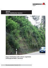
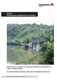
Slope <strong>stabilization</strong> / Photo documentation / March 2010<br />
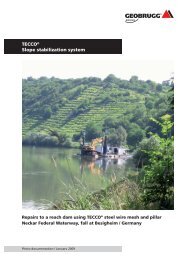
<strong>TECCO</strong> ®<br />
<strong>slope</strong> <strong>stabilization</strong><br />
Weisenbach-Langenbrand / Germany<br />
2<br />
Object: Slope 2.10, Weisenbach-Langenbrand in the<br />
Murgtal region, alongside the B 462 road<br />
Building promoter: Federal Republic of Germany, represented by the<br />
Karlsruhe Regional Council, Construction Offi ce<br />
Mitte (Central), Germany<br />
Geotechnical investigations,<br />
planning, construction<br />
supervision: Ingenieurgruppe Geotechnik GbR, Kirchzarten,<br />
Germany<br />
Contractor: Sachtleben Mining Services GmbH, Wolfach,<br />
Germany<br />
Implementation: October/November 2009<br />
Slope <strong>stabilization</strong>: <strong>TECCO</strong> ® -mesh covering in combination with nails<br />
Max. <strong>slope</strong> height: H = approx. 15 m<br />
Subsoil: Granite<br />
Area: 2‘000 m2 Slope gradient: α = 80 degrees<br />
Mesh: <strong>TECCO</strong> ® -<strong>system</strong> G65/3 mm<br />
Erosion control mat: TECMAT<br />
Spike plates: <strong>TECCO</strong> ® -<strong>system</strong> G65/3 mm<br />
Nails: GEWI D = 32 mm<br />
Nail length: L = 6 m / 3 m<br />
Nail grid: a = b = 3 m<br />
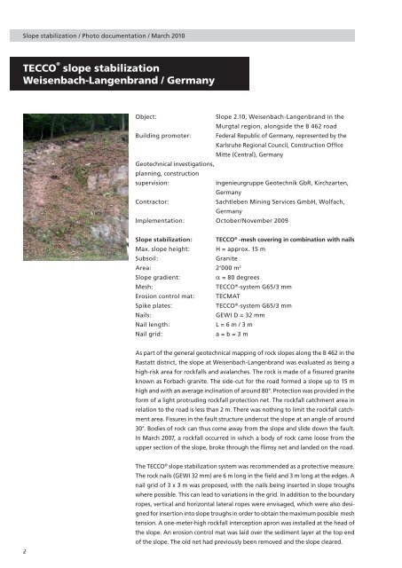
As part of the general geotechnical mapping of rock <strong>slope</strong>s along the B 462 in the<br />
Rastatt district, the <strong>slope</strong> at Weisenbach-Langenbrand was evaluated as being a<br />
high-risk area for rockfalls and avalanches. The rock is made of a fi ssured granite<br />
known as Forbach granite. The side-cut for the road formed a <strong>slope</strong> up to 15 m<br />
high and with an average inclination of around 80°. Protection was provided in the<br />
form of a light protruding rockfall protection net. The rockfall catchment area in<br />
relation to the road is less than 2 m. There was nothing to limit the rockfall catchment<br />
area. Fissures in the fault structure undercut the <strong>slope</strong> at an angle of around<br />
30°. Bodies of rock can thus come away from the <strong>slope</strong> and slide down the fault.<br />
In March 2007, a rockfall occurred in which a body of rock came loose from the<br />
upper section of the <strong>slope</strong>, broke through the fl imsy net and landed on the road.<br />
The <strong>TECCO</strong> ® <strong>slope</strong> <strong>stabilization</strong> <strong>system</strong> was recommended as a protective measure.<br />
The rock nails (GEWI 32 mm) are 6 m long in the fi eld and 3 m long at the edges. A<br />
nail grid of 3 x 3 m was proposed, with the nails being inserted in <strong>slope</strong> troughs<br />
where possible. This can lead to variations in the grid. In addition to the boundary<br />
ropes, vertical and horizontal lateral ropes were envisaged, which were also designed<br />
for insertion into <strong>slope</strong> troughs in order to obtain the maximum possible mesh<br />
tension. A one-meter-high rockfall interception apron was installed at the head of<br />
the <strong>slope</strong>. An erosion control mat was laid over the sediment layer at the top end<br />
of the <strong>slope</strong>. The old net had previously been removed and the <strong>slope</strong> cleared.