Nuns Canyon Vineyard
Nuns Canyon Vineyard - V&E Properties
Nuns Canyon Vineyard - V&E Properties

You also want an ePaper? Increase the reach of your titles
YUMPU automatically turns print PDFs into web optimized ePapers that Google loves.
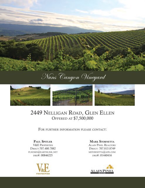
<strong>Nuns</strong> <strong>Canyon</strong> <strong>Vineyard</strong><br />
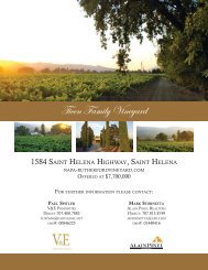
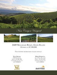
2449 Nelligan Road, Glen Ellen<br />
Offered at $7,500,000<br />
For further information please contact:<br />
Paul Spitler<br />
V&E Properties<br />
Direct:707.480.7882<br />
plndmn@earthlink.net<br />
dre#: 00846225<br />
Mark Stornetta<br />
Alain Pinel Realtors<br />
Direct: 707.815.8749<br />
mstornetta@apr.com<br />
dre#: 01440416
<strong>Nuns</strong> <strong>Canyon</strong> <strong>Vineyard</strong>s ~ Glen Ellen
Price $7,500,000<br />
<strong>Nuns</strong> <strong>Canyon</strong> <strong>Vineyard</strong><br />
Property Description<br />
Assessor’s Parcel #<br />
Address:<br />
Parcel Size:<br />
Location:<br />
Zoning:<br />
Appellation:<br />
Physical Features:<br />
051-180-011 fee simple. There is an easement in perpetuity covering adjacent<br />
parcel AP 051-180-012 for agricultural purposes and an agriculure easement<br />
maintenance agreement covering AP 051-180-013.<br />
2449 Nelligan Road, Glen Ellen, CA<br />
134.23+/- acres per Sonoma County Assessor<br />
<strong>Nuns</strong> <strong>Canyon</strong> <strong>Vineyard</strong> is located on the southwestern slope of the Mayacmas<br />
Mountains and about 15 minutes from Glen Ellen and Kenwood.<br />
LIA B6 100 Z, SR and type II Williamson Ag contract.<br />
Sonoma Valley<br />
This 114.1+/- acre vineyard is planted on gentle to steep slopes on the<br />
Mayacamas Mountain range at elevations of 1,300-1,755’. Southwestern<br />
exposure allows this vineyard site to enjoy full sun exposure and produce high<br />
quality red varietals. Grape varietals include Cabernet Sauvignon, Cabernet<br />
Franc, Merlot, Sangiovese and Zinfandel. The vineyard is separated into 20<br />
blocks planted from 1994 to 2008. Spacing is a combination of double, 12x8 and<br />
9x6. 9 acres of Syrah were grafted to Cabernet Franc in 2011.<br />
Varietal plantings are:<br />
Varietal Acres<br />
Varietal Acres (+/-) as a % of Total<br />
Cabernet Sauvignon 50.27 44%<br />
Merlot 34.51 30%<br />
Zinfandel 14.32 13%<br />
Sangiovese 2.99 3%<br />
Cabernet Franc 11.39 10%<br />
Total 113.48 100%<br />
The NCRS defines the soils for the area as Red Hill Clay Loam.<br />
Panoramic views sweep over the Valley of the Moon towards San Pablo Bay<br />
and the west.<br />
Fruit characteristics:<br />
Grape Sales:<br />
Straight forward berry character, similar to Napa style.<br />
Wines produced from this vineyard are made by St. Francis Winery.<br />
Wine quality as reported by the winery is excellent. Wine samples are available<br />
upon request.<br />
Structures:<br />
Utilities:<br />
Water Source<br />
None.<br />
Electric.<br />
Three agricultural wells. There is no frost protection.<br />
This information was gathered from third party sources including the seller and public records, without further verification.<br />
Prospective buyers are advised to verify all information and to retain appropriate professionals to obtain advice or assistance.
Sonoma County - PRMD ActiveMap Interactive Mapping Appli...<br />
http://imsportal.sonoma-county.org/ActiveMap/images/PrintTe...<br />
Created on 9/28/2011 at 10:54AM<br />
1 of 1 9/28/11 10:55 AM
Sonoma County PRMD ActiveMap Property Report<br />
http://imsportal.sonoma-county.org/ActiveMap/<br />
051-180-011<br />
Acres* 134.23<br />
Zoning<br />
Land Use<br />
Land Use Policies<br />
Planning Area Polices<br />
Planning Area<br />
Urban Service Areas<br />
Groundwater Availability<br />
Areas<br />
Area and Specific Plan<br />
Redevelopment Plan<br />
Local Area Development<br />
Guideline<br />
Williamson Act Land<br />
Contract<br />
City Sphere of Influence<br />
City Urban Growth<br />
Flood Prone Urban Area<br />
Air Quality Control Board<br />
Waiver Prohibition Area<br />
Water Quality Control<br />
Board<br />
Wet Weather Zone<br />
Supervisor<br />
District<br />
Fire Protection<br />
Responsibility Area<br />
USGS Quad<br />
LIA B6 100 Z, SR<br />
LIA100<br />
Not Applicable<br />
Not Applicable<br />
9 - Sonoma Valley<br />
Not Applicable<br />
Zone 3 - Marginal groundwater, Zone 4 - Areas with low<br />
or highly variable water yield<br />
North Sonoma Valley Specific Plan<br />
Not Applicable<br />
Taylor/Sonoma/Mayacamas Design Guideline<br />
Type II Contract<br />
Not Applicable<br />
Not Applicable<br />
Not Applicable<br />
Bay Area Air Quality Management District<br />
Not Applicable<br />
San Francisco Bay Region<br />
C - Santa Rosa<br />
District 1 - Valerie Brown<br />
State<br />
28D, 28F<br />
*Source: Sonoma County Assessor<br />
1 of 2 9/28/11 10:37 AM
Permit History Lookup: Parcel Number 051-180-011<br />
http://prmd.sonoma-county.org/permit_history_lookup.aspx?si...<br />
Permit History as of August 10, 2011<br />
Number Date Status Type Description Scanned<br />
WEL07-0139 4/18/2007 Finaled B-WEL NEW CLASS I WATER WELL Yes<br />
WEL02-0390 8/1/2002 Finaled B-WEL NEW WATER WELL WELL SITING WITH DON<br />
GARNER. APPROVED BY JJOHNSON 8/7/02<br />
ROUTED TO WELL FILE 8/14/2 SG 11/1/02 LOG<br />
RCVD, ROUTED TO WELL FILE#2 SG 6/3/04<br />
FINALED-COPIES TO ASSESSOR AND DRILLER.<br />
PERMIT ROUTED TO HARD FILE. JM<br />
Yes<br />
BLD02-2325 5/17/2002 Finaled B-BLD NEW DIESEL FUEL TANK FOR AG USE<br />
LLA01-0097 12/20/2001 Dropped C-LLA REQUEST FOR A MAJOR LLA . REQUEST FOR A<br />
MAJOR LOT LINE ADJUSTMENT BETWEEN<br />
10PARCELS RESULTING FROM ACCS. EXISTING<br />
PARCEL SIZES ARE: 188, 35, 11.5, 18, 18, 26.5, 272, 179,<br />
15, AND 31 ACRES. RESULTING SIZES WILL BE:<br />
EIGHT 10 ACRE PARCELS, ONE 5 ACRE PARCEL<br />
AND A 700ACRE PARCEL. PARCELS ARE UNDER AN<br />
AG PRESERVE TYPE 2.<br />
SEV99-1191 10/12/1999 Archived SITE-W/S LOT 10 SITE REVIEW ROUTED TO JHILE 10/13/99<br />
RFS SENT 2/8/00, ROUTED TO HARD FILE<br />
Yes<br />
B-154141 5/24/1999 Finaled A-BLD INSTALL NEW SRVC 100AMP 3PHASE<br />
METER/MAIN-SUB PAN-PANEL W/ELEC OUTLETS<br />
& FUTURE 5HP PUMP-AG IRRIGAT-<br />
VINEYARD.-COMM<br />
Number Date Status Type Description Scanned<br />
Important Notes<br />
The Permit History provided may not include all records for this property. Further investigation may be required to obtain a<br />
more complete history, due to: address changes, parcel mergers, splits, retirements, etc.<br />
Date(s) listed in this report reflect the earliest known date(s) associated with each file. The date(s) listed are not associated<br />
with the current status.<br />
Permit Status Definitions (PDF: 57 kB) have<br />
been modified through time, to better identify milestones during the life span of a specific File Type. Many historical files<br />
reflect statuses which are no longer in use.<br />
2 of 2 8/10/11 12:14 PM
2449 Nelligan Road<br />
Crop Production History<br />
Total Tons<br />
Grape Varietal Acres Percent 2007 2008 2009 2010 2011<br />
Cabernet Sauvignon 50.27 44% 186.0 67.0 117.0 133.1 105.0<br />
Merlot 34.51 30% 193.0 56.0 81.0 95.0 34.0<br />
Zinfandel 14.32 13% 68.0 36.0 37.0 35.2 22.0<br />
Syrah (see note) 8.39 7% 33.0 10.0 17.0 8.2 -‐<br />
Sangiovese 2.99 3% 9.0 3.0 5.0 2.9 2.0<br />
Cabernet Franc 3.00 3% 9.0 5.0 8.0 3.7<br />
Total 113.48 100% 498.0 177.0 265.0 278.1 163.0<br />
Tons/Acre<br />
Grape Varietal Acres Percent 2007 2008 2009 2010 2011<br />
Cabernet Sauvignon 50.27 44% 3.7 1.3 2.3 2.6 7.5<br />
Merlot 34.51 30% 5.6 1.6 2.3 2.8 1.0<br />
Zinfandel 14.32 13% 4.7 2.5 2.6 2.5 1.5<br />
Syrah (see note) 8.39 7% 3.9 1.2 2.0 1.0 -‐<br />
Sangiovese 2.99 3% 3.0 1.0 1.7 1.0 0.7<br />
Cabernet Franc 3.00 3% 3.0 1.7 2.7 1.2 -‐<br />
Total 113.48 100% 4.4 1.6 2.3 2.5 1.4<br />
Note: Syrah grafted to Cabernet Franc in 2011
Aerial Overview of <strong>Nuns</strong> <strong>Canyon</strong> <strong>Vineyard</strong><br />
2449 Nelligan Road, Glen Ellen<br />
APN#: 051-180-011<br />
Presented by: Mark Stornetta & Paul Spitler<br />
Mark Stornetta<br />
Alain Pinel Realtors<br />
Direct: 707.815.8749<br />
mstornetta@apr.com<br />
DRE#: 01440416<br />
Paul Spitler<br />
V&E Properties<br />
Direct: 707.480.7882<br />
plndmn@earthlink.net<br />
DRE#: 00846225<br />
Block Varietal Acres Spacing Clone Rootstock Year Planted<br />
7 110 2002<br />
1<br />
Cabernet <br />
Sauvignon<br />
7.45 Double<br />
7 110 2008<br />
7 039-‐16 1994<br />
22<br />
23<br />
2<br />
Cabernet <br />
Sauvignon<br />
3.44 Double<br />
2002<br />
7 039-‐16 1994<br />
7 110 2002<br />
St. George<br />
18<br />
21 20<br />
19<br />
3 Zinfandel 3.7 12x8<br />
Old Zinfandel 039-‐16 1994<br />
Old Zinfandel 100<br />
4<br />
Cabernet <br />
Sauvignon<br />
4.96 Double 7 110 2002<br />
Old Zinfandel AXR 1 1980's<br />
5 Zinfandel 7.87 12x8<br />
Old Zinfandel 110 2008<br />
16<br />
17<br />
16<br />
easement<br />
15<br />
14<br />
12<br />
private property<br />
9<br />
6<br />
5<br />
24<br />
6<br />
Double<br />
9 Merlot 11.87 Double<br />
10<br />
12<br />
14<br />
Cabernet <br />
Sauvignon<br />
Cabernet <br />
Sauvignon<br />
Cabernet <br />
Sauvignon<br />
Cab Franc<br />
6.54<br />
1.41<br />
0.86<br />
Double<br />
10.04 12x8<br />
Old Zinfandel 110 1994<br />
7 110 2008<br />
7 039-‐16 1994<br />
7 110 2002<br />
3 039-‐16 1994<br />
3 110 2006<br />
7 110 2002<br />
412 110 2007<br />
7 110 1994<br />
7 110 1996<br />
Estrella 110 1994<br />
Estrella 110 2006/2007<br />
15<br />
Cab Franc 3.24<br />
Estrella 110 1994<br />
Estrella 110 2006/2007<br />
Legend<br />
well<br />
gate<br />
2<br />
10<br />
3<br />
1<br />
4<br />
16<br />
17<br />
Cab Franc Estrella 110 1994<br />
7.29<br />
Cabernet <br />
110 1994<br />
Franc<br />
9x6 7 110 1994<br />
Cabernet <br />
Sauvignon<br />
9.09<br />
12x8 7 110 1994<br />
7 110 2008<br />
7 110 2002<br />
18<br />
Cabernet <br />
Sauvignon<br />
0.84 9x6 7 110 1994<br />
19 Merlot 3.64 9x6 7 110 1994<br />
20 Zinfandel 2.75 9x6 Old Zinfandel 110 1994<br />
21<br />
Cabernet <br />
Sauvignon<br />
6.5 9x6 7 1103P 1994<br />
22 1.16 110 1994<br />
Sangiovese<br />
23 1.83 110 2002&2003<br />
24 Merlot 19<br />
3 110 1994<br />
3 110 1996<br />
Total 113.48<br />
While the information contained in this spreadsheet has been obtained from<br />
sources believed to be reliable, it is not guaranteed to be accurate or complete.<br />
Prospect buyers are advised to independently verify the accuracy of all information.
Aerial Overview of <strong>Nuns</strong> <strong>Canyon</strong> <strong>Vineyard</strong><br />
2449 Nelligan Road, Glen Ellen<br />
APN#: 051-180-011<br />
Presented by: Mark Stornetta & Paul Spitler<br />
Mark Stornetta<br />
Alain Pinel Realtors<br />
Direct: 707.815.8749<br />
mstornetta@apr.com<br />
DRE#: 01440416<br />
Paul Spitler<br />
V&E Properties<br />
Direct: 707.480.7882<br />
plndmn@earthlink.net<br />
DRE#: 00846225<br />
<strong>Nuns</strong> <strong>Canyon</strong> <strong>Vineyard</strong> Block Detail<br />
Block Varietal Acres Spacing Clone Rootstock Year Planted Notes<br />
7 110 2002 Middle Block | Middle Rows<br />
1<br />
Cabernet <br />
Sauvignon<br />
7.45 Double<br />
7 110 2008 Middle Block | End of Rows<br />
7 039-‐16 1994 Left and Right of Center<br />
V<br />
I<br />
2<br />
4<br />
Cabernet <br />
Sauvignon<br />
3 Zinfandel 3.7<br />
Cabernet <br />
Sauvignon<br />
3.44 Double<br />
12x8<br />
5 Zinfandel 7.87 12x8<br />
7 039-‐16 1994<br />
2002 In-‐Between Rows<br />
Original Rows contain >5% AXR1 <br />
Vines<br />
7 110 2002 In-‐Between Rows<br />
St. George<br />
Primary Stock<br />
Old Zinfandel 039-‐16 1994 Small Area Replacement Program<br />
Old Zinfandel 100 Misc. Recent Replacements<br />
4.96 Double 7 110 2002<br />
Old Zinfandel AXR 1 1980's Upper Half<br />
Old Zinfandel 110 2008 Interplanted in Upper Half<br />
B<br />
N<br />
6<br />
Cabernet <br />
Sauvignon<br />
6.54<br />
Double<br />
Old Zinfandel 110 1994 Bottom Half<br />
7 110 2008 Replacement Planting<br />
7 039-‐16 1994 Ends of Original Rows<br />
L<br />
7 110 2002 In-‐Between Rows<br />
E<br />
9 Merlot 11.87 Double<br />
3 039-‐16 1994 Original Rows<br />
3 110 2006 In-‐Between Rows<br />
Y<br />
10<br />
12<br />
Cabernet <br />
Sauvignon<br />
Cabernet <br />
Sauvignon<br />
1.41<br />
Double<br />
10.04 12x8<br />
7 110 2002 Original Rows<br />
412 110 2007 In-‐Between Rows<br />
7 110 1994 Original Rows<br />
7 110 1996 Interplanted<br />
O<br />
C<br />
A<br />
R<br />
14<br />
15<br />
16<br />
Cab Franc<br />
0.86<br />
Estrella 110 1994 2011 Grafted Syrah to Cab Franc<br />
Estrella 110 2006/2007 Replacement of Vines with Issues<br />
Cab Franc 3.24<br />
Grafted from Syrah to Cab Franc in <br />
Estrella 110 1994<br />
2011<br />
Estrella 110 2006/2007 Replacement of Vines with Issues<br />
Cab Franc Estrella 110 1994<br />
90% as Listed | 10% Unknown <br />
Grafted from Syrah to Cab Franc in <br />
7.29<br />
2011<br />
Cabernet <br />
Franc<br />
110 1994 Last two rows were Cabernet Franc.<br />
K<br />
S<br />
D<br />
17<br />
Cabernet <br />
Sauvignon<br />
9.09<br />
9x6 7 110 1994 Upper Section<br />
12x8 7 110 1994<br />
Lower Section | Ends, Grafted 300+/-‐ <br />
vines to Cab Franc<br />
7 110 2008 Lower Section | Middle<br />
18<br />
Cabernet <br />
Sauvignon<br />
7 110 2002 Lower Section | In-‐Between<br />
0.84 9x6 7 110 1994<br />
19 Merlot 3.64 9x6 7 110 1994<br />
20 Zinfandel 2.75 9x6 Old Zinfandel 110 1994<br />
21<br />
Cabernet <br />
Sauvignon<br />
6.5 9x6 7 1103P 1994<br />
22 1.16 110 1994<br />
Sangiovese<br />
23 1.83 110 2002&2003<br />
24 Merlot 19<br />
Total 113.48<br />
Replanting for Missing and Sick <br />
Vines<br />
3 110 1994 Original Rows<br />
3 110 1996 In-‐Between Rows<br />
While the information contained in this spreadsheet has been obtained from sources believed to be reliable, it is not<br />
guaranteed to be accurate or complete. Prospect buyers are advised to independently verify the accuracy of all information.
Aerial Overview of <strong>Nuns</strong> <strong>Canyon</strong> <strong>Vineyard</strong><br />
2449 Nelligan Road, Glen Ellen<br />
APN#: 051-180-011<br />
Presented by: Mark Stornetta & Paul Spitler<br />
Mark Stornetta<br />
Alain Pinel Realtors<br />
Direct: 707.815.8749<br />
mstornetta@apr.com<br />
DRE#: 01440416<br />
Paul Spitler<br />
V&E Properties<br />
Direct: 707.480.7882<br />
plndmn@earthlink.net<br />
DRE#: 00846225<br />
B<br />
subject property<br />
A<br />
051-180-006<br />
I<br />
051-180-007<br />
J<br />
053-030-018<br />
C<br />
Kistler <strong>Vineyard</strong>s Llc<br />
A. 051-200-012<br />
Lazy K Land<br />
B. 051-180-014<br />
H. 051-250-015<br />
Montecillo <strong>Vineyard</strong>s Llc<br />
C. 053-030-018<br />
Jane Kunde Family Lmt Ptp<br />
D. 051-250-010<br />
Vendimia Llc<br />
E. 053-040-037<br />
Ridgeview <strong>Vineyard</strong>s Llc<br />
F. 053-040-001<br />
Blair Maus<br />
G. 053-040-036<br />
Smith Charles John<br />
I. 051-180-006<br />
J. 051-180-007<br />
D<br />
E<br />
F<br />
G<br />
H
Aerial Overview of <strong>Nuns</strong> <strong>Canyon</strong> <strong>Vineyard</strong><br />
2449 Nelligan Road, Glen Ellen<br />
APN#: 051-180-011<br />
Presented by: Mark Stornetta & Paul Spitler<br />
Mark Stornetta<br />
Alain Pinel Realtors<br />
Direct: 707.815.8749<br />
mstornetta@apr.com<br />
DRE#: 01440416<br />
Paul Spitler<br />
V&E Properties<br />
Direct: 707.480.7882<br />
plndmn@earthlink.net<br />
DRE#: 00846225<br />
16<br />
17<br />
Legend<br />
well<br />
gate<br />
15<br />
18<br />
21 20<br />
easement<br />
16<br />
14<br />
22<br />
19<br />
23<br />
12<br />
private property<br />
10<br />
3<br />
2<br />
1<br />
9<br />
6<br />
5<br />
4<br />
24<br />
While the information contained in this spreadsheet has been obtained from sources believed to be reliable, it is not<br />
guaranteed to be accurate or complete. Prospect buyers are advised to independently verify the accuracy of all information.
Cost Category 2010 Per Acre<br />
Producing Acres 112.49<br />
Salaries and Wages 301,607 2,681<br />
Wages harvest 52,519 467<br />
Payroll taxes 33,499 298<br />
Workers Comp 11,931 106<br />
Health 29,944 266<br />
401K 7,562 67<br />
Total Comp and Ben 437,062 3,885<br />
Insurance 3,688 33<br />
Other 5,861 52<br />
Trucking 8,887 79<br />
Fuel 7,740 69<br />
Safety Supplies 2,670 24<br />
Small tools and equip 1,428 13<br />
Erosion control 3,146 28<br />
Irrigation materials 200 2<br />
Pesticides/Fertilizers/ Sprays 54,429 484<br />
Equip lease / rent 6,980 62<br />
Outside svcs 7,467 66<br />
Telephone 3,330 30<br />
Maintenance and Repair 18,677 166<br />
Supplies 2,414 21<br />
Electric 7,770 69<br />
Other Costs 134,687 1,197<br />
Total Farming Costs 571,749 5,083
38° 25' 38''<br />
38° 24' 41''<br />
4251600<br />
4251800<br />
4252000<br />
4252200<br />
4252400<br />
4252600<br />
4252800<br />
4253000<br />
4253200<br />
122° 31' 25'' 122° 31' 24''<br />
541600<br />
541600<br />
±<br />
541800<br />
RhE<br />
541800<br />
542000<br />
542000<br />
RoG<br />
542200<br />
RhE<br />
542200<br />
Map Scale: 1:8,320 if printed on A size (8.5" x 11") sheet.<br />
Meters<br />
0 50 100 200 300<br />
Custom Soil Resource Report<br />
Soil Map<br />
0 300 600 1,200 1,800<br />
Feet<br />
542400<br />
Nelligan Rd<br />
542400<br />
RhE<br />
RhD<br />
542600<br />
542600<br />
RhF<br />
542800<br />
542800<br />
122° 30' 31''<br />
122° 30' 31''<br />
4251600<br />
4251800<br />
4252000<br />
4252200<br />
4252400<br />
4252600<br />
4252800<br />
4253000<br />
4253200<br />
38° 25' 38''<br />
38° 24' 41''
Custom Soil Resource Report<br />
MAP LEGEND<br />
MAP INFORMATION<br />
Area of Interest (AOI)<br />
Area of Interest (AOI)<br />
Soils<br />
Soil Map Units<br />
Special Point Features<br />
Blowout<br />
Borrow Pit<br />
Clay Spot<br />
Closed Depression<br />
Gravel Pit<br />
Gravelly Spot<br />
Landfill<br />
Lava Flow<br />
Marsh or swamp<br />
Mine or Quarry<br />
Miscellaneous Water<br />
Perennial Water<br />
Rock Outcrop<br />
Saline Spot<br />
Sandy Spot<br />
Severely Eroded Spot<br />
Sinkhole<br />
Slide or Slip<br />
Sodic Spot<br />
Spoil Area<br />
Stony Spot<br />
Very Stony Spot<br />
Wet Spot<br />
Other<br />
Special Line Features<br />
Gully<br />
Short Steep Slope<br />
Other<br />
Political Features<br />
Cities<br />
Water Features<br />
Streams and Canals<br />
Transportation<br />
Rails<br />
Interstate Highways<br />
US Routes<br />
Major Roads<br />
Local Roads<br />
Map Scale: 1:8,320 if printed on A size (8.5" × 11") sheet.<br />
The soil surveys that comprise your AOI were mapped at 1:20,000.<br />
Warning: Soil Map may not be valid at this scale.<br />
Enlargement of maps beyond the scale of mapping can cause<br />
misunderstanding of the detail of mapping and accuracy of soil line<br />
placement. The maps do not show the small areas of contrasting<br />
soils that could have been shown at a more detailed scale.<br />
Please rely on the bar scale on each map sheet for accurate map<br />
measurements.<br />
Source of Map: Natural Resources Conservation Service<br />
Web Soil Survey URL: http://websoilsurvey.nrcs.usda.gov<br />
Coordinate System: UTM Zone 10N NAD83<br />
This product is generated from the USDA-NRCS certified data as of<br />
the version date(s) listed below.<br />
Soil Survey Area: Sonoma County, California<br />
Survey Area Data: Version 4, Dec 12, 2007<br />
Date(s) aerial images were photographed: 6/22/2005<br />
The orthophoto or other base map on which the soil lines were<br />
compiled and digitized probably differs from the background<br />
imagery displayed on these maps. As a result, some minor shifting<br />
of map unit boundaries may be evident.
Custom Soil Resource Report<br />
Map Unit Legend<br />
Sonoma County, California (CA097)<br />
Map Unit Symbol Map Unit Name Acres in AOI Percent of AOI<br />
RhD RED HILL CLAY LOAM, 2 TO 15<br />
PERCENT SLOPES<br />
RhE RED HILL CLAY LOAM, 15 TO 30<br />
PERCENT SLOPES<br />
RhF RED HILL CLAY LOAM, 30 TO 50<br />
PERCENT SLOPES<br />
30.0 23.1%<br />
22.9 17.7%<br />
30.1 23.2%<br />
RoG ROCK LAND 46.9 36.1%<br />
Totals for Area of Interest 130.0 100.0%<br />
Map Unit Descriptions<br />
The map units delineated on the detailed soil maps in a soil survey represent the soils<br />
or miscellaneous areas in the survey area. The map unit descriptions, along with the<br />
maps, can be used to determine the composition and properties of a unit.<br />
A map unit delineation on a soil map represents an area dominated by one or more<br />
major kinds of soil or miscellaneous areas. A map unit is identified and named<br />
according to the taxonomic classification of the dominant soils. Within a taxonomic<br />
class there are precisely defined limits for the properties of the soils. On the landscape,<br />
however, the soils are natural phenomena, and they have the characteristic variability<br />
of all natural phenomena. Thus, the range of some observed properties may extend<br />
beyond the limits defined for a taxonomic class. Areas of soils of a single taxonomic<br />
class rarely, if ever, can be mapped without including areas of other taxonomic<br />
classes. Consequently, every map unit is made up of the soils or miscellaneous areas<br />
for which it is named and some minor components that belong to taxonomic classes<br />
other than those of the major soils.<br />
Most minor soils have properties similar to those of the dominant soil or soils in the<br />
map unit, and thus they do not affect use and management. These are called<br />
noncontrasting, or similar, components. They may or may not be mentioned in a<br />
particular map unit description. Other minor components, however, have properties<br />
and behavioral characteristics divergent enough to affect use or to require different<br />
management. These are called contrasting, or dissimilar, components. They generally<br />
are in small areas and could not be mapped separately because of the scale used.<br />
Some small areas of strongly contrasting soils or miscellaneous areas are identified<br />
by a special symbol on the maps. If included in the database for a given area, the<br />
contrasting minor components are identified in the map unit descriptions along with<br />
some characteristics of each. A few areas of minor components may not have been<br />
observed, and consequently they are not mentioned in the descriptions, especially<br />
where the pattern was so complex that it was impractical to make enough observations<br />
to identify all the soils and miscellaneous areas on the landscape.<br />
The presence of minor components in a map unit in no way diminishes the usefulness<br />
or accuracy of the data. The objective of mapping is not to delineate pure taxonomic<br />
classes but rather to separate the landscape into landforms or landform segments that<br />
10
Custom Soil Resource Report<br />
have similar use and management requirements. The delineation of such segments<br />
on the map provides sufficient information for the development of resource plans. If<br />
intensive use of small areas is planned, however, onsite investigation is needed to<br />
define and locate the soils and miscellaneous areas.<br />
An identifying symbol precedes the map unit name in the map unit descriptions. Each<br />
description includes general facts about the unit and gives important soil properties<br />
and qualities.<br />
Soils that have profiles that are almost alike make up a soil series. Except for<br />
differences in texture of the surface layer, all the soils of a series have major horizons<br />
that are similar in composition, thickness, and arrangement.<br />
Soils of one series can differ in texture of the surface layer, slope, stoniness, salinity,<br />
degree of erosion, and other characteristics that affect their use. On the basis of such<br />
differences, a soil series is divided into soil phases. Most of the areas shown on the<br />
detailed soil maps are phases of soil series. The name of a soil phase commonly<br />
indicates a feature that affects use or management. For example, Alpha silt loam, 0<br />
to 2 percent slopes, is a phase of the Alpha series.<br />
Some map units are made up of two or more major soils or miscellaneous areas.<br />
These map units are complexes, associations, or undifferentiated groups.<br />
A complex consists of two or more soils or miscellaneous areas in such an intricate<br />
pattern or in such small areas that they cannot be shown separately on the maps. The<br />
pattern and proportion of the soils or miscellaneous areas are somewhat similar in all<br />
areas. Alpha-Beta complex, 0 to 6 percent slopes, is an example.<br />
An association is made up of two or more geographically associated soils or<br />
miscellaneous areas that are shown as one unit on the maps. Because of present or<br />
anticipated uses of the map units in the survey area, it was not considered practical<br />
or necessary to map the soils or miscellaneous areas separately. The pattern and<br />
relative proportion of the soils or miscellaneous areas are somewhat similar. Alpha-<br />
Beta association, 0 to 2 percent slopes, is an example.<br />
An undifferentiated group is made up of two or more soils or miscellaneous areas that<br />
could be mapped individually but are mapped as one unit because similar<br />
interpretations can be made for use and management. The pattern and proportion of<br />
the soils or miscellaneous areas in a mapped area are not uniform. An area can be<br />
made up of only one of the major soils or miscellaneous areas, or it can be made up<br />
of all of them. Alpha and Beta soils, 0 to 2 percent slopes, is an example.<br />
Some surveys include miscellaneous areas. Such areas have little or no soil material<br />
and support little or no vegetation. Rock outcrop is an example.<br />
11
Custom Soil Resource Report<br />
Sonoma County, California<br />
RhD—RED HILL CLAY LOAM, 2 TO 15 PERCENT SLOPES<br />
Map Unit Setting<br />
Elevation: 500 to 2,500 feet<br />
Mean annual precipitation: 30 to 50 inches<br />
Mean annual air temperature: 54 to 55 degrees F<br />
Frost-free period: 240 to 260 days<br />
Map Unit Composition<br />
Red hill and similar soils: 85 percent<br />
Minor components: 15 percent<br />
Description of Red Hill<br />
Setting<br />
Landform: Hills<br />
Landform position (two-dimensional): Backslope<br />
Landform position (three-dimensional): Side slope<br />
Down-slope shape: Linear<br />
Across-slope shape: Linear<br />
Parent material: Residuum weathered from andesite<br />
Properties and qualities<br />
Slope: 2 to 15 percent<br />
Depth to restrictive feature: 48 to 80 inches to paralithic bedrock<br />
Drainage class: Moderately well drained<br />
Capacity of the most limiting layer to transmit water (Ksat): Moderately high (0.20 to<br />
0.57 in/hr)<br />
Depth to water table: More than 80 inches<br />
Frequency of flooding: None<br />
Frequency of ponding: None<br />
Available water capacity: High (about 10.4 inches)<br />
Interpretive groups<br />
Land capability classification (irrigated): 3e<br />
Land capability (nonirrigated): 3e<br />
Typical profile<br />
0 to 16 inches: Clay loam<br />
16 to 48 inches: Clay loam<br />
48 to 80 inches: Clay<br />
Minor Components<br />
Boomer<br />
Percent of map unit: 10 percent<br />
Goulding<br />
Percent of map unit: 5 percent<br />
12
Custom Soil Resource Report<br />
RhE—RED HILL CLAY LOAM, 15 TO 30 PERCENT SLOPES<br />
Map Unit Setting<br />
Elevation: 500 to 2,500 feet<br />
Mean annual precipitation: 30 to 50 inches<br />
Mean annual air temperature: 54 to 55 degrees F<br />
Frost-free period: 240 to 260 days<br />
Map Unit Composition<br />
Red hill and similar soils: 85 percent<br />
Minor components: 15 percent<br />
Description of Red Hill<br />
Setting<br />
Landform: Hills<br />
Landform position (two-dimensional): Backslope<br />
Landform position (three-dimensional): Side slope<br />
Down-slope shape: Concave<br />
Across-slope shape: Convex<br />
Parent material: Residuum weathered from andesite<br />
Properties and qualities<br />
Slope: 15 to 30 percent<br />
Depth to restrictive feature: More than 80 inches<br />
Drainage class: Moderately well drained<br />
Capacity of the most limiting layer to transmit water (Ksat): Moderately high (0.20 to<br />
0.57 in/hr)<br />
Depth to water table: More than 80 inches<br />
Frequency of flooding: None<br />
Frequency of ponding: None<br />
Available water capacity: High (about 10.4 inches)<br />
Interpretive groups<br />
Land capability classification (irrigated): 4e<br />
Land capability (nonirrigated): 4e<br />
Typical profile<br />
0 to 16 inches: Clay loam<br />
16 to 48 inches: Clay loam<br />
48 to 80 inches: Clay<br />
Minor Components<br />
Boomer<br />
Percent of map unit: 5 percent<br />
Goulding<br />
Percent of map unit: 5 percent<br />
13
Custom Soil Resource Report<br />
Josephine<br />
Percent of map unit: 5 percent<br />
RhF—RED HILL CLAY LOAM, 30 TO 50 PERCENT SLOPES<br />
Map Unit Setting<br />
Elevation: 500 to 2,500 feet<br />
Mean annual precipitation: 30 to 50 inches<br />
Mean annual air temperature: 54 to 55 degrees F<br />
Frost-free period: 240 to 260 days<br />
Map Unit Composition<br />
Red hill and similar soils: 85 percent<br />
Minor components: 15 percent<br />
Description of Red Hill<br />
Setting<br />
Landform: Hills<br />
Landform position (two-dimensional): Backslope<br />
Landform position (three-dimensional): Side slope<br />
Down-slope shape: Convex<br />
Across-slope shape: Convex<br />
Parent material: Residuum weathered from andesite<br />
Properties and qualities<br />
Slope: 30 to 50 percent<br />
Depth to restrictive feature: More than 80 inches<br />
Drainage class: Moderately well drained<br />
Capacity of the most limiting layer to transmit water (Ksat): Moderately high (0.20 to<br />
0.57 in/hr)<br />
Depth to water table: More than 80 inches<br />
Frequency of flooding: None<br />
Frequency of ponding: None<br />
Available water capacity: High (about 10.4 inches)<br />
Interpretive groups<br />
Land capability (nonirrigated): 6e<br />
Typical profile<br />
0 to 16 inches: Clay loam<br />
16 to 48 inches: Clay loam<br />
48 to 80 inches: Clay<br />
Minor Components<br />
Boomer<br />
Percent of map unit: 4 percent<br />
Goulding<br />
Percent of map unit: 4 percent<br />
14
Custom Soil Resource Report<br />
Josephine<br />
Percent of map unit: 4 percent<br />
Sites<br />
Percent of map unit: 3 percent<br />
RoG—ROCK LAND<br />
Map Unit Setting<br />
Elevation: 650 to 4,000 feet<br />
Mean annual precipitation: 8 to 15 inches<br />
Mean annual air temperature: 45 to 52 degrees F<br />
Frost-free period: 110 to 180 days<br />
Map Unit Composition<br />
Rock land: 85 percent<br />
Minor components: 15 percent<br />
Description of Rock Land<br />
Setting<br />
Parent material: Residuum weathered from igneous, metamorphic and sedimentary<br />
rock<br />
Properties and qualities<br />
Slope: 50 to 75 percent<br />
Depth to restrictive feature: 0 to 10 inches to lithic bedrock<br />
Drainage class: Excessively drained<br />
Available water capacity: Very low (about 0.0 inches)<br />
Interpretive groups<br />
Land capability (nonirrigated): 8<br />
Typical profile<br />
0 to 10 inches: Unweathered bedrock<br />
Minor Components<br />
Unnamed<br />
Percent of map unit: 15 percent<br />
15
Article 04. - LIA Land Intensive Agriculture District.<br />
http://library.municode.com/HTML/16331/level2/CH26SOC...<br />
Sonoma County, California, Code of Ordinances >> CHAPTER 26 - SONOMA COUNTY ZONING<br />
REGULATIONS >> Article 04. - LIA Land Intensive Agriculture District. >><br />
Article 04. - LIA Land Intensive Agriculture District.<br />
Copy link to clipboard<br />
Sec. 26-04-005. - Purpose.<br />
Sec. 26-04-010. - Permitted uses.<br />
Sec. 26-04-020. - Uses permitted with a use permit.<br />
Sec. 26-04-030. - Permitted residential density and development criteria.<br />
Sec. 26-04-005. - Purpose.<br />
Purpose: to enhance and protect lands best suited for permanent agricultural use and capable of relatively<br />
high production per acre of land; and to implement the provisions of the land intensive agriculture land use<br />
category (Section 2.7.1) of the general plan and the policies of the agricultural resources element.<br />
(Ord. No. 4643, 1993.)<br />
Sec. 26-04-010. - Permitted uses.<br />
(a)<br />
(b)<br />
(c)<br />
(d)<br />
On parcels exceeding two (2) acres, raising, feeding, maintaining and breeding of farm animals.<br />
When such farming involves animals which are continuously confined, such as veal calves, poultry,<br />
hogs and pigs, dairy cows, or similar livestock which may result in concentrations of animal waste,<br />
the use shall be subject to issuance of a zoning permit based upon written approval of the Sonoma<br />
County public health department and the applicable Regional Water Quality Control Board of a<br />
confined animal management plan. Horses, goats, sheep and similar farm animals are not<br />
considered to be confined animals for purposes of this chapter. The plan shall include provisions for:<br />
(1) Containment of waste to the site,<br />
(2) Reuse or disposal of waste in accordance with health and/or water quality regulations,<br />
(3) Mitigation of potential water quality impacts due to surface runoff of waste,<br />
(4) Control of vectors.<br />
In the event that the confined animal use is proposed within five hundred feet (500′) of a<br />
nonagricultural land use category, it shall require prior approval of a use permit;<br />
On parcels of two (2) acres or less, raising, feeding, maintaining and breeding of not more than one<br />
(1) of the following per twenty thousand (20,000) square feet of area:<br />
(1) Five (5) hogs or pigs,<br />
(2) One (1) horse, mule, cow or steer,<br />
(3) Five (5) goats, sheep or similar animals,<br />
(4) Fifty (50) chickens or similar fowl,<br />
(5) Fifty (50) ducks or geese or one hundred (100) rabbits or similar animals.<br />
(6) The above limitations may be modified by the planning director upon submittal of a proposal<br />
statement which describes the extent of the domestic farming use and which is signed by the<br />
owners of all property within three hundred feet (300′) of the subject property. The planning<br />
director may require the applicant to obtain a use permit if the director determines that the<br />
project might be detrimental to surrounding uses.<br />
(7) 4-H and FFA animal husbandry projects are permitted without limitation of parcel size,<br />
provided that the parcel contains at least twenty thousand (20,000) square feet and provided<br />
further a letter of project authorization is first submitted by the project advisor. The planning<br />
director may require the applicant to obtain a use permit when the director determines that the<br />
project might be detrimental to surrounding uses;<br />
Beekeeping;<br />
The growing and harvesting of shrubs, plants, flowers, trees, vines, fruits, vegetables, hay, grain and<br />
1 of 8 10/20/11 10:19 AM
Article 04. - LIA Land Intensive Agriculture District.<br />
http://library.municode.com/HTML/16331/level2/CH26SOC...<br />
(e)<br />
(f)<br />
(g)<br />
(h)<br />
similar food and fiber crops, including wholesale nurseries. Except as noted below, agricultural<br />
cultivation shall not be permitted in the following areas:<br />
(1) Within one hundred feet (100′) from the top of the bank of the Russian River Riparian<br />
Corridor,<br />
(2) Within fifty feet (50′) from the top of the bank of designated flatland riparian corridors,<br />
(3) Within twenty-five feet (25′) from the top of the bank of designated upland riparian corridors,<br />
Agricultural cultivation may be allowed in those areas designated in subsection (d)(1) through (3)<br />
above upon approval of a management plan which includes appropriate mitigations for potential<br />
erosion, bank stabilization and biotic impacts. This plan may be approved by the planning director or<br />
by use permit pursuant to Section 26-04-020(a);<br />
Agricultural support services involving no more than one (1) employee and occupying no more than<br />
one-half (½) acre of land and subject, at a minimum to the criteria of general plan Policies AR-5c and<br />
AR-5d. Such services may include incidental sales of products related to the support service use but<br />
shall not include additional walk-in, over-the-counter retail sales.<br />
The following factors shall be considered in determining an agricultural support service to be "clearly<br />
subordinate to on-site agricultural production" as provided in above Policy AR-5c:<br />
(1) The geographic area of the lot devoted to the support service use in comparison to that<br />
remaining in agricultural production,<br />
(2) Whether or not new structures or significant expansion of existing structures are needed to<br />
accommodate the support service use,<br />
(3) The relative number of employees devoted to the support service use in comparison to that<br />
needed for agricultural production;<br />
Incidental cleaning, grading, packing, polishing, sizing and similar preparation of crops which are<br />
grown on the site, but not including agricultural processing;<br />
Temporary or seasonal sales and promotion and incidental storage of crops which are grown or<br />
animals which are raised on the site;<br />
Residential uses include the following:<br />
(1) Single-family detached dwelling unit(s) in accordance with the residential density permitted by<br />
the general plan land use element, or permitted by a "B" combining district, whichever is more<br />
restrictive. These unit(s) may be manufactured homes, but only one (1) may be a<br />
manufactured home without a permanent foundation.<br />
A manufactured home without a permanent foundation shall require prior approval of a zoning<br />
permit notice of which shall be posted at least ten (10) days prior to issuance, during which an<br />
appeal may be filed and processed pursuant to Section 26-92-040. Issuance of the zoning<br />
permit shall be subject, at a minimum, to the following conditions:<br />
(i) The manufactured home shall be at least twelve feet (12′) in width except those that<br />
are owned and occupied on the effective date of the ordinance codified in this chapter,<br />
(ii) The manufactured home shall be skirted. All skirting shall be of a type approved by the<br />
state of California,<br />
(iii) The manufactured home shall have one patio awning with a minimum dimension of<br />
nine feet (9′) by twenty feet (20′) and either a garage, carport or awning with a<br />
minimum dimension of ten feet (10′) by twenty feet (20′) for covered parking,<br />
(iv) All manufactured home sites shall be landscaped, and<br />
(v) The manufactured home shall be occupied by the owner of the property or a relative of<br />
the owner,<br />
(2) One (1) detached farm family dwelling unit per lot provided that a Williamson Act contract is in<br />
effect and that the following requirements are met:<br />
(i) An agricultural easement having a term equal to the useful life of the structure, but in<br />
no event less than twenty (20) years, shall be offered to the county at the time of<br />
application,<br />
(ii) A covenant shall be recorded, in a form satisfactory to county counsel, which<br />
acknowledges that, in the event that the agricultural use is terminated on the property,<br />
the farm family dwelling shall become a nonconforming residential use,<br />
(3) One (1) dwelling unit for full-time agricultural employees for each of the following agricultural<br />
2 of 8 10/20/11 10:19 AM
Article 04. - LIA Land Intensive Agriculture District.<br />
http://library.municode.com/HTML/16331/level2/CH26SOC...<br />
(i)<br />
uses conducted on the site:<br />
(i) At least fifty (50) mature cows or one hundred (100) beef cattle,<br />
(ii) At least twenty (20) acres of grapes, apples, pears, prunes,<br />
(iii) At least twenty thousand (20,000) broilers, fifteen thousand (15,000) egg-layers or<br />
three thousand (3,000) turkeys,<br />
(iv) At least two hundred fifty (250) sheep or goats, fifty (50) dairy goats or hogs,<br />
(v) At least thirty (30) mature horses,<br />
(vi) Wholesale nurseries with a minimum of either one (1) acre of propagating greenhouse<br />
or outdoor containers or three (3) acres of field-grown plant materials,<br />
(vii) Any other agricultural use which the planning director determines to be of the same<br />
approximate agricultural value and intensity as subsections (h)(3)(i) through (vi) of this<br />
section.<br />
The dwelling unit(s) may be conventionally built homes or manufactured homes (with or<br />
without permanent foundations); provided, that manufactured homes without a permanent<br />
foundation shall require a zoning permit approved in the manner described in subsection<br />
(h)(1) of this section. Prior to the issuance of building or zoning permits for the employee<br />
unit(s), the property owner shall place on file with the planning department an affidavit that the<br />
unit(s) will be used to house persons employed on the premises for agricultural purposes.<br />
Further, a covenant shall be recorded, in a form satisfactory to county counsel, which<br />
acknowledges that in the event that the agricultural use is terminated on the property, the<br />
agricultural employee dwelling shall become a nonconforming residential use,<br />
(4) Self-contained recreational vehicles and/or travel trailers to house persons solely employed<br />
on the site for agricultural purposes for less than ninety (90) days, subject to the following:<br />
The property owner must submit a written affidavit to the planning department, stating that the<br />
recreational vehicle and/or travel trailer will only be used to house persons solely employed<br />
on the site of a bona fide agricultural enterprise. A "bona fide agricultural enterprise" is<br />
defined, for this purpose, as an operation which derives its primary and principal income from<br />
agricultural production. The recreational vehicle or trailer shall be immediately removed from<br />
the site when it is no longer occupied by persons who are solely employed on the site,<br />
(5) Seasonal farmworker housing which meets the standards set forth in Section 26-88-010(l).<br />
Seasonal farmworker housing shall also conform to such public health, building and fire safety<br />
criteria as may be established by resolution or ordinance of the board of supervisors,<br />
(6) Year-round farmworker housing which meets the standards set forth in Section 26-88-010(p).<br />
Year-round farmworker housing shall also conform to such public health, building and fire<br />
safety criteria as may be established by resolution or ordinance of the board of supervisors,<br />
(7) One guest house per lot,<br />
(8) One (1) travel trailer per lot for use as temporary housing in accordance with Section<br />
26-88-010(q) and provided that a travel trailer administrative permit is obtained and renewed<br />
annually;<br />
(9) One (1) second dwelling unit per lot, pursuant to Section 26-88-060, provided that the water<br />
supply for the second dwelling unit is proposed to be located within a designated Class 1, 2 or<br />
3 groundwater availability area. Second units may be established within designated Class 4<br />
water-scarce areas only where a hydro-geotechnical report, as defined, certifies that the<br />
establishment and continuation of the secondary residential use will not have significant<br />
adverse impacts on local or cumulative groundwater availability or yield.<br />
The following nonagricultural uses; provided, that the applicant must demonstrate that the use meets<br />
a local need, avoids conflict with agricultural activities and is consistent with Objective AR-4.1 and<br />
Policy AR-4a of the Agricultural Resources Element:<br />
(1) Boarding of horses subject to issuance of a zoning permit,<br />
(2) Home occupations subject to the requirements of Section 26-88-121 and approval of a zoning<br />
permit. Any home occupation use on a parcel under a Williamson Act contract must be<br />
consistent with Government Code Section 51200 et seq. (the Williamson Act) and local rules,<br />
regulations and ordinances adopted thereunder,<br />
(3) Small residential community care facilities,<br />
(4) Occasional cultural events, provided that a written notice stating "The Sonoma County<br />
3 of 8 10/20/11 10:19 AM
Article 04. - LIA Land Intensive Agriculture District.<br />
http://library.municode.com/HTML/16331/level2/CH26SOC...<br />
(5)<br />
(6)<br />
(7)<br />
(8)<br />
(9)<br />
(10)<br />
(11)<br />
(12)<br />
Planning Department will issue a zoning permit for a cultural event (state nature and duration)<br />
on this property if a written appeal is not received within ten (10) days from the date of this<br />
notice," is posted on the property at least ten (10) days prior to issuance of a zoning permit,<br />
and no appeal pursuant to Section 26-92-040 has been received from any interested person,<br />
and provided that approval is secured from the following departments: sheriff, public health,<br />
fire services, building inspection and public works. In the event of an appeal, a hearing on the<br />
project shall be held pursuant to Section 26-92-040<br />
Management of land for watershed, for fish and wildlife habitat, fish rearing ponds, hunting<br />
and fishing, where these uses are incidental to the primary use,<br />
Small family day care,<br />
Pet fancier facilities, provided, that a pet fancier license is obtained from the division of animal<br />
regulation and renewed annually,<br />
Public parks,<br />
Craft sales and garage sales not exceeding two (2) sales days per calendar year provided<br />
that prior notification is given to the California Highway Patrol and that adequate off-street<br />
parking is provided,<br />
Attached commercial telecommunication facilities subject to the applicable criteria set forth in<br />
Section 26-88-130<br />
Minor freestanding commercial telecommunication facilities, subject to the applicable criteria<br />
set forth in Section 26-88-130, and subject to approval of a zoning permit, including<br />
environmental review, for which notice, including a site plan and one (1) elevation with<br />
dimensions for such facility, is mailed to adjacent property owners and posted on the subject<br />
property at least ten (10) days prior to issuance of the permit and provided that no appeal<br />
pursuant to Section 26-92-040 has been received from any interested person. In the event of<br />
an appeal, a hearing on the project shall be held pursuant to the above section,<br />
Noncommercial telecommunication facilities eighty feet (80′) or less in height subject to the<br />
applicable criteria set forth in Section 26-88-130. Facilities between forty feet (40′) and eighty<br />
feet (80′) in height are subject to approval of a ministerial zoning permit for which notice is<br />
mailed to adjacent property owners and posted on the subject property at least ten (10) days<br />
prior to issuance of the permit and provided that no appeal pursuant to Section 26-92-040 has<br />
been received from any interested person. In the event of an appeal, a hearing on the project<br />
shall be held pursuant to the above section,<br />
(13) Small wind energy systems not located within a county-designated urban service area or<br />
within two thousand five hundred feet (2,500′) of a county-designated urban service area,<br />
subject to zoning permit approval and the standards in Section 26-88-135<br />
(j) Accessory buildings and uses appurtenant to the operation of the permitted uses. Accessory<br />
buildings may be constructed on vacant parcels of two (2) acres or more in advance of a primary<br />
permitted use. On vacant parcels less than two (2) acres, accessory buildings may only be<br />
constructed if less than one hundred twenty (120) square feet or as incidental to an existing<br />
agricultural use;<br />
(k) Minor timberland conversions, subject to compliance with the requirements of Section 26-88-140<br />
(l) Other nonresidential uses which in the opinion of the planning director are of a similar and<br />
compatible nature to those uses described in this section.<br />
(Ord. No. 5569 § 7, 2005; Ord. No. 5435 § 2(b), 2003; Ord. No. 5429 § 3(a), 2003; Ord. No. 5361 § 2(a), 2002; Ord.<br />
No. 5342 § 4, 2002; Ord. No. 5016 § 1(A), 1997; Ord. No. 4985 § 1(b), 1996; Ord. No. 4973 § 3(a), 1996; Ord. No.<br />
4723 § 1(b), 1993; Ord. No. 4653 § 1(c), 1993; Ord. No. 4643, 1993.)<br />
Sec. 26-04-020. - Uses permitted with a use permit.<br />
(a)<br />
Agricultural cultivation in the following areas, for which a management plan has not been approved<br />
pursuant to Section 26-04-010(d):<br />
(1) Within one hundred feet (100′) from the top of the bank in the Russian River Riparian<br />
Corridor,<br />
(2) Within fifty feet (50′) from the top of the bank in designated flatland riparian corridors,<br />
(3) Within twenty-five feet (25′) from the top of the bank in designated upland riparian corridors;<br />
4 of 8 10/20/11 10:19 AM
Article 04. - LIA Land Intensive Agriculture District.<br />
http://library.municode.com/HTML/16331/level2/CH26SOC...<br />
(b)<br />
(c)<br />
(d)<br />
(e)<br />
(f)<br />
(g)<br />
(h)<br />
(i)<br />
(j)<br />
(k)<br />
(l)<br />
(m)<br />
(n)<br />
Livestock feed yards, animal sales yards;<br />
Commercial mushroom farming;<br />
Commercial stables not permitted under Section 26-04-010(i)(1), riding academies, equestrian riding<br />
and driving clubs, and hunting clubs;<br />
Commercial aquaculture, provided that, at a minimum, the use does not adversely affect biotic<br />
resources and does not take place on prime soils;<br />
Agricultural support services with more than one (1) and a maximum of three (3) employees or<br />
occupying more than one half (½) acre of land, but otherwise subject to the same criteria as Section<br />
26-04-010(e);<br />
Preparation of agricultural products which are not grown on site, processing of agricultural product of<br />
a type grown or produced primarily on site or in the local area, storage of agricultural products grown<br />
or processed on site, and bottling or canning of agricultural products grown or processed on site,<br />
subject, at a minimum, to the criteria of general plan Policies AR-5e and AR-5f;<br />
Slaughterhouses, animal processing plants, rendering plants, fertilizer plants or yards which serve<br />
agricultural production in the local area and subject, at a minimum, to the criteria of general plan<br />
Policies AR-5e and AR-5f;<br />
Retail nurseries involving crops/plants which are not grown on the site;<br />
Tasting rooms and other temporary, seasonal or year-round sales and promotion of agricultural<br />
products grown or processed in the county subject to the minimum criteria of general plan Policies<br />
AR-6d and AR-6g. This subsection shall not be interpreted so as to require a use permit for uses<br />
allowed by Section 26-04-010(g);<br />
Promotional or marketing accommodations for private guests, provided, that the use, at a minimum,<br />
meets all of the following criteria:<br />
(1) The use promotes or markets agricultural products grown or processed on the site,<br />
(2) The scale of the use is appropriate to the production and/or processing use on the site,<br />
(3) The use complies with general plan Policies AR-6d and AR-6g,<br />
(4) No commercial use of private guest accommodations is allowed;<br />
Dwelling unit(s) for full time agricultural employees which are transferred from another lot within this<br />
district and which are under the same ownership as the subject property. The number of units<br />
allowed shall be determined by the standards in Section 26-04-010(h)(3). The units shall be located<br />
on the receiving parcel such that they are closer to the primary dwelling unit than to the property line;<br />
Farm labor camps not permitted by Section 26-04-010(h);<br />
The following nonagricultural uses; provided, that the applicant must demonstrate that the use meets<br />
a local need, avoids conflict with agricultural activities and is consistent with Objective AR-4.1 and<br />
Policy AR-4a of the Agricultural Resources Element:<br />
(1) Game preserves and refuges;<br />
(2) Public schools, subject, at a minimum, to the criteria of general plan Policy LU-6e;<br />
(3) Private nursery, primary or secondary schools, and churches subject, at a minimum, to the<br />
criteria of general plan Policy LU-6f;<br />
(4) Cemeteries;<br />
(5) Commercial kennels;<br />
(6) Minor public service uses or facilities (transmission and distribution lines and<br />
telecommunication facilities excepted), including but not limited to reservoirs, storage tanks,<br />
pumping stations, transformer stations, fire and police stations and training centers, service<br />
yards and related parking lots which, at a minimum, meet the criteria of general plan Policy<br />
PF-2s and which are not otherwise exempt by state law;<br />
(7) Intermediate and major freestanding commercial telecommunication facilities subject at a<br />
minimum to the applicable criteria set forth in Section 26-88-130<br />
(8) Noncommercial telecommunication facilities greater than eighty feet (80′) in height subject at<br />
a minimum to the applicable criteria set forth in Section 26-88-130<br />
(9) Exploration and development of low temperature geothermal resources for other than power<br />
development purposes provided that at a minimum it is compatible with surrounding land<br />
uses;<br />
(10) Application of sludge from wastewater treatment plants to agricultural land subject, at a<br />
5 of 8 10/20/11 10:19 AM
Article 04. - LIA Land Intensive Agriculture District.<br />
http://library.municode.com/HTML/16331/level2/CH26SOC...<br />
(o)<br />
(11)<br />
(12)<br />
(13)<br />
(14)<br />
(15)<br />
(16)<br />
minimum, to the criteria of general plan Policies PF-2q and PF-2r;<br />
Art studios and arts and crafts centers not involving retail or wholesale sales. A use permit for<br />
such uses may be granted only when the use is conducted within an existing abandoned<br />
agricultural building feasible for such use;<br />
Granges and similar community service facilities which do not adversely impact agriculture in<br />
the area;<br />
Large residential community care facility;<br />
Day care center;<br />
Large family day care;<br />
Golf courses and driving ranges shall be at the sole discretion of the county and subject, at a<br />
minimum, to the following criteria:<br />
(i) The proposed use is adjacent to a designated urban service boundary or includes an<br />
irrevocable offer of offsite unutilized development rights for all lands between the use<br />
and the urban service boundary,<br />
(ii) Permanent open space or agricultural preservation is provided for the site of the<br />
proposed use and all areas for which development rights are acquired,<br />
(iii) The use is located in close proximity to an existing wastewater treatment facility and<br />
includes the use of reclaimed wastewater in accordance with the regulations of the<br />
applicable regional water quality control agency,<br />
(iv) The use is subject to design review approval and includes setbacks, buffers or other<br />
measures designed to minimize its impact on existing and potential agricultural uses in<br />
the area,<br />
(v) Under no circumstances shall housing be included as part of the use, provided that a<br />
caretaker unit may be considered,<br />
(vi) The use must be compatible with and not result in limitations on any agricultural<br />
operation,<br />
(vii) The use shall not be conducted on lands subject to a Williamson Act contract or<br />
included in a Timber Production Zone,<br />
(viii) Facilities associated with the golf course and/or driving range shall be limited to those<br />
which serve golfers on the course or range, such as locker and shower facilities, pro<br />
shop with incidental sales of golfing equipment, snack bar and maintenance<br />
operations. Such facilities shall not include restaurants, other retail sales, lodging or<br />
similar uses,<br />
(ix) Driving ranges shall not be operated during nighttime hours.<br />
In the event that the above uses are proposed within a designated community separator, the<br />
criteria established by general plan Policy OS-1c shall supersede the above criteria,<br />
Craft sales and garage sales involving three (3) or four (4) sales days per year;<br />
(17)<br />
(18) Small wind energy systems located within a county-designated urban service area or within<br />
two thousand five hundred feet (2,500′) of a county-designated urban service area, subject to<br />
the standards in Section 26-88-135<br />
Live/work uses in conjunction with a legally established single family residential unit subject to the<br />
requirements of Section 26-88-122. Any live/work use on a parcel under Williamson Act contract<br />
must be consistent with Government Code Section 51200 et seq. (the Williamson Act) and local<br />
rules, regulations and ordinances adopted thereunder.<br />
(p) Other nonresidential uses which in the opinion of the planning director area of a similar and<br />
compatible nature to those uses described in this section.<br />
(Ord. No. 5569 § 7, 2005; Ord. No. 5435 § 2(c), 2003; Ord. No. 5429 § 3, 2003; Ord. No. 5361 § 2(i), 2002; Ord. No.<br />
5342 § 4, 2002; Ord. No. 4973 § 3(b), 1996; Ord. No. 4781 § 2(B), 1994; Ord. No. 4643, 1993.)<br />
Sec. 26-04-030. - Permitted residential density and development criteria.<br />
The use of land and structures within this district is subject to this article, the general regulations of this<br />
chapter, and the provisions of any district which is combined herewith. Policies and criteria of the general<br />
plan and any applicable specific or area plan or local area development guidelines shall supersede the<br />
standards herein.<br />
6 of 8 10/20/11 10:19 AM
Article 04. - LIA Land Intensive Agriculture District.<br />
http://library.municode.com/HTML/16331/level2/CH26SOC...<br />
(a)<br />
(b)<br />
(c)<br />
(d)<br />
(e)<br />
(f)<br />
Density. Residential density shall be between twenty (20) and one hundred (100) acres per<br />
dwelling unit as shown in the general plan land use element or permitted by a "B" combining<br />
district, whichever is more restrictive. However, dwelling units described in Section<br />
26-04-010(h)(2) through (7) inclusive may be permitted in addition to the residential density.<br />
Minimum Lot Size. The minimum lot size for creation of new parcels shall be twenty (20)<br />
acres, provided, that it shall also meet the criteria of general plan Policy AR-8c. In such cases<br />
where lots are clustered, a protective easement shall be applied to the remaining large<br />
parcel(s) which indicates that density has been transferred to the clustered area.<br />
Minimum Lot Width. The minimum average lot width within each lot is one hundred twenty-five<br />
feet (125′).<br />
Maximum Building Height.<br />
(1) Thirty-five feet (35′) except that agricultural buildings and structures may reach up to<br />
fifty feet (50′). Additional height may be permitted provided that site plan approval in<br />
accordance with Article 82 is first secured.<br />
(2) Maximum height for telecommunication facilities is subject to the provisions of this<br />
article and Section 26-88-130<br />
Maximum Lot Coverage. Thirty-five percent (35%). Lot coverage limitations may be waived by<br />
the planning director for commercial greenhouses and swimming pools.<br />
Yard Requirements.<br />
(1) Front or Street Side Yard. Thirty feet (30′) except where combined with any B district<br />
and in no case shall the setback be less than fifty-five feet (55′) from the centerline of<br />
all roads and streets, except as may be otherwise indicated on the district maps.<br />
(2) Side Yard. Minimum ten feet (10′), except that in the case of a corner lot, the street<br />
side yard shall be the same as the front yard.<br />
(3) Rear Yard. Twenty feet (20′).<br />
(4) Watering troughs, feed troughs, accessory buildings used for the housing or<br />
maintenance of farm animals and accessory buildings and runs used for the housing or<br />
maintenance of kennel animals shall be located at least fifty feet (50′) from the front<br />
property line, twenty feet (20′) from any side or rear property line, and thirty feet (30′)<br />
from any dwelling on the adjacent property.<br />
(5) No garage or carport opening facing the street shall be located less than twenty feet<br />
(20′) from any exterior property line, except that where twenty-five percent (25%) or<br />
more of the lots on any one (1) block or portion thereof in the same zoning district have<br />
been improved with garages or carports, the required front yard may be reduced to a<br />
depth equal to the average of the front yards of the such garages or carports. However,<br />
in no case shall the front yards be reduced to less than ten feet (10′). Further, the<br />
permit and resource management department director may require a use permit if the<br />
reduction might result in a traffic hazard.<br />
Notwithstanding the above, if a residence is elevated to meet flood requirements, the<br />
space underneath the structure may be utilized for a garage or carport if it will meet<br />
building codes, even if the ten foot (10′) to twenty foot (20′) setback cannot be met,<br />
subject to approval of administrative design review.<br />
(6) Cornices, eaves, canopies, bay windows, fireplaces and/or other cantilevered portions<br />
of structures, and similar architectural features may extend two feet (2′) into any<br />
required yard. The maximum length of the projections shall not occupy more than<br />
one-third of the total length of the wall on which it is located. Uncovered porches, fire<br />
escapes or landing places may extend six feet (6′) into any required front or rear yard<br />
and three feet (3′) into any required side yard.<br />
(7) Where twenty-five percent (25%) or more of the lots on any one (1) block or portion<br />
thereof in the same zoning district have been improved with buildings, the required<br />
front yard may be reduced to a depth equal to the average of the front yards of the<br />
improved lots, subject to the limitations of subsection (f)(5) of this section.<br />
(8) Accessory buildings may be constructed within the required yards on the rear half of<br />
the lot; provided, that such buildings shall not occupy more than thirty percent (30%) of<br />
the width of any rear yard. Such accessory buildings shall not be located closer than<br />
7 of 8 10/20/11 10:19 AM
Article 04. - LIA Land Intensive Agriculture District.<br />
http://library.municode.com/HTML/16331/level2/CH26SOC...<br />
ten feet (10′) to the main buildings on adjacent lots. Notwithstanding the foregoing,<br />
swimming pools may occupy more than thirty percent (30%) of the width of any rear<br />
yard. A minimum of three feet (3′) shall be maintained between the wall of a pool and<br />
the rear and side property lines, and from the main building on the same lot.<br />
Conventional pool accessory equipment (pump, filters, etc.) shall be exempt from<br />
setback restrictions. Additional setbacks may be required under the Uniform Building<br />
Code.<br />
(Ord. No. 3932.)<br />
(9) The yard requirements of subsections (f)(1) and (2) of this section may be reduced up<br />
to fifty percent (50%) for agricultural buildings and structures if necessary for efficient<br />
farming operation.<br />
(g) In compliance with applicable sections of the State Subdivision Map Act and the subdivision<br />
ordinance, a two (2)-way division of a parcel of land that is currently subject to a Williamson<br />
Act contract may be allowed, if all of the following apply:<br />
(1) The resulting parcel is to be sold or leased for agricultural employee ("farmworker")<br />
housing, and is not more than five (5) acres in size. For the purposes of this section,<br />
"agricultural employee" shall have the same meaning as defined by subdivision (b) of<br />
Section 1140.4 of the Labor Code.<br />
(2) The parcel shall be sold or leased to a nonprofit organization, a city, a county, a<br />
housing authority, or a state agency, for the sole purpose of the provision and operation<br />
of farmworker housing. A lessee that is a nonprofit organization shall not sublease that<br />
parcel without the written consent of the landowner, and shall notify the county of such<br />
sublease.<br />
(3) The parcel to be sold or leased shall be subject to a deed restriction that limits the use<br />
of the parcel to farmworker housing facilities for not less than thirty (30) years. The<br />
deed restriction shall also provide, through reversionary or similar provision, that the<br />
parcel shall automatically revert to and be merged with the parcel from which it was<br />
subdivided when the parcel ceases to be used for farmworker housing for a period of<br />
more than one (1) year. The deed restriction shall be in a form satisfactory to county<br />
counsel.<br />
(4) There is a written agreement between the parties to the sale or lease of the parcel and<br />
their successors to operate the parcel to be sold or leased under joint management of<br />
the parties, subject to the terms and conditions and for the duration of the Williamson<br />
Act contract.<br />
(5) The parcel to be sold or leased is contiguous to one (1) or more parcels that are<br />
located within a designated urban service area, and which are zoned for and<br />
developed with urban residential, commercial, or industrial land uses.<br />
(6) The farmworker housing project is provided pursuant to Section 26-88-010(l) (Seasonal<br />
farmworker housing) or Section 26-88-010(o) (Year-round farmworker housing), and<br />
includes provisions designed to minimize potential impacts on surrounding agricultural<br />
and rural residential land uses.<br />
A subdivision of land pursuant to this section shall not affect any Williamson Act contract<br />
executed pursuant to Article 3 (commencing with Section 51240) of the Government Code,<br />
and the parcel to be sold or leased shall remain subject to that contract.<br />
(Ord. No. 5711 § 7 (Exh. H), 2007; Ord. No. 5569 § 9, 2005; Ord. No. 4973 § 1(c), 1996; Ord. No. 4927 §§ 1, 6, 11,<br />
1996; Ord. No. 4643, 1993.)<br />
8 of 8 10/20/11 10:19 AM
Article 64. - SR Scenic Resources Combining District.<br />
http://library.municode.com/HTML/16331/level2/CH26SOC...<br />
Sonoma County, California, Code of Ordinances >> CHAPTER 26 - SONOMA COUNTY ZONING<br />
REGULATIONS >> Article 64. - SR Scenic Resources Combining District. >><br />
Article 64. - SR Scenic Resources Combining District.<br />
Copy link to clipboard<br />
Sec. 26-64-005. - Purpose.<br />
Sec. 26-64-010. - Development criteria.<br />
Sec. 26-64-020. - Community separators and scenic landscape units.<br />
Sec. 26-64-030. - Scenic corridors.<br />
Sec. 26-64-040. - Telecommunication facilities in the SR district.<br />
Sec. 26-64-050. - Design review approval.<br />
Sec. 26-64-005. - Purpose.<br />
Purpose: to preserve the visual character and scenic resources of lands in the county and to implement the<br />
provisions of Sections 2.1, 2.2 and 2.3 of the general plan open space element.<br />
(Ord. No. 4643, 1993.)<br />
Sec. 26-64-010. - Development criteria.<br />
Maximum building heights, minimum lot areas and lot widths, yard requirements and maximum<br />
percentages of lot coverage shall comply with the requirements for the districts with which the SR<br />
regulations are combined unless otherwise provided herein.<br />
(Ord. No. 4643, 1993.)<br />
Sec. 26-64-020. - Community separators and scenic landscape units.<br />
(a)<br />
(b)<br />
All structures, except certain telecommunications facilities as provided for in Section 26-64-040,<br />
located within community separators and scenic landscape units illustrated on Figures OS-5a<br />
through OS-5i, inclusive, of the general plan open space element and included within the SR district<br />
shall be subject to the following criteria:<br />
(1) Structures shall be sited below exposed ridgelines;<br />
(2) Structures shall use natural landforms and existing vegetation to screen them from view from<br />
public roads. On exposed sites, screening with native, fire resistant plants may be required;<br />
(3) Cuts and fills are discouraged, and where practical, driveways are screened from public view;<br />
(4) Utilities are placed underground where economically practical;<br />
The above criteria shall not apply to agricultural accessory structures which do not require a use<br />
permit in the district with which this district is combined.<br />
In the event that compliance with these standards would make a parcel unbuildable, structures shall<br />
be sited where minimum visual impacts would result.<br />
In addition to the criteria listed in subsection (a) of this section, the following standards shall apply to<br />
subdivisions within community separators and scenic landscape units and included within the SR<br />
district unless otherwise provided herein:<br />
(1) Building envelopes shall be established for structures. Use of height limitations should be<br />
considered, if necessary to further mitigate visual impacts;<br />
(2) Clustering shall be used to reduce visual impact where consistent with the applicable base<br />
district;<br />
(3) Building sites and roadways shall be located to preserve trees and tree stands as provided in<br />
Section 26-88-040(m) of this chapter;<br />
(4) To the extent allowed by law, dedication of a permanent scenic or agricultural easement shall<br />
be required at the time of subdivision for projects in community separators. Consider requiring<br />
1 of 3 10/20/11 10:20 AM
Article 64. - SR Scenic Resources Combining District.<br />
http://library.municode.com/HTML/16331/level2/CH26SOC...<br />
such easements in critical scenic landscape units pursuant to general plan Policy OS-2g.<br />
(c) Where development occurs on parcels located both within scenic landscape units and adjacent to<br />
scenic corridors, the more restrictive provisions set forth in this article shall apply.<br />
(d) Additional or varied development may be allowed in designated community separators and scenic<br />
landscape units in accordance with general plan Policies OS-1c, and OS-2c, respectively.<br />
(e) Minor timberland conversions shall be allowed within community separators and scenic landscape<br />
units, subject to compliance with the requirements of this article and Section 2-88-140.<br />
(f) Certain single-family dwelling units and appurtenant structures within the area covered by the Taylor<br />
Mountain/Sonoma Mountain development guidelines shall be subject to Section 26-90-050, as<br />
specified therein. Where the provisions of this section conflict with the provisions of Section<br />
26-90-050, the general plan, or any applicable area plan, the more restrictive provisions shall apply.<br />
(Ord. No. 5132 § 2, 1999: Ord. No. 4985 § 1(d), 1996; Ord. No. 4973 § 12(a), 1996; Ord. No. 4643, 1993.)<br />
Sec. 26-64-030. - Scenic corridors.<br />
The following provisions shall apply to properties along scenic corridors illustrated on Figures OS-5a<br />
through OS-5i, inclusive, of the general plan open space element unless otherwise provided herein:<br />
(a) All structures located within scenic corridors established outside of the urban service area<br />
boundaries shown on Figures LU-5a through LU-5i, inclusive, of the general plan land use<br />
element shall be subject to the setbacks of thirty percent (30%) of the depth of the lot to a<br />
maximum of two hundred feet (200′) from the centerline of the road. Development within the<br />
setback shall be prohibited with the following exceptions, where such uses are allowed by the<br />
base district with which this district is combined:<br />
(b)<br />
(c)<br />
(d)<br />
(e)<br />
(1)<br />
(2)<br />
(3)<br />
(4)<br />
(5)<br />
New barns and similar agricultural support structures which are added to existing farm<br />
complexes provided that such structures proposed within a state scenic highway or<br />
where local design review exists by community choice in an adopted specific or area<br />
plan are subject to design review;<br />
New barns and similar agricultural support structures which do not require a use permit<br />
in this chapter; provided, however, that such structures proposed within a State Scenic<br />
Highway or where local design review exists by community choice in an adopted<br />
specific or area plan are subject to design review;<br />
Maintenance, restoration, reconstruction or minor expansion of existing structures;<br />
Certain telecommunication facilities as provided in Section 26-64-040<br />
Other new structures provided they are subject to design review and<br />
(i) They are associated with existing structures,<br />
(ii) There is no other reasonable location for the structure,<br />
(iii) The location within the setback is necessary for the use, or<br />
(iv) Existing vegetation and topography screen the use;<br />
Compliance with the setback would render the parcel unbuildable;<br />
(6)<br />
(7) Satellite dishes which are not visible from the roadway.<br />
Where the scenic corridor setback provided for in Section 26-64-030(a), conflicts with the<br />
scenic corridor setback along Highway 12 established by Ordinance 1810, the latter shall<br />
apply.<br />
A building setback of twenty feet (20′) shall be applied along the Highway 101 scenic corridor<br />
to properties which are within the urban service area boundaries shown on Figures LU-5b,<br />
-5c, -5e, -5g, and -5h of the general plan land use element, to be reserved for landscaping.<br />
Where development occurs on parcels located both within scenic landscape units and<br />
adjacent to scenic corridors, the more restrictive provisions set forth in this article shall apply.<br />
Building permits within the setback established in Section 26-64-030(a) along Bohemian<br />
Highway between Occidental and Freestone and Bodega Highway between Bodega and<br />
Freestone shall be referred to the county landmarks commission for review and<br />
recommendation.<br />
(Ord. No. 4973 § 12(b), 1996; Ord. No. 4643, 1993.)<br />
2 of 3 10/20/11 10:20 AM
Article 64. - SR Scenic Resources Combining District.<br />
http://library.municode.com/HTML/16331/level2/CH26SOC...<br />
Sec. 26-64-040. - Telecommunication facilities in the SR district.<br />
The following provisions shall apply to telecommunication facilities on properties in community separators,<br />
scenic landscape units, and scenic corridors as shown on Figures OS-5a through OS-5i, inclusive, of the<br />
general plan open space element.<br />
Telecommunication facilities which are allowed by the applicable base district shall meet the provisions of<br />
said base district and the applicable standards of Section 26-64-020 or 26-64-030, except that:<br />
(a) An attached commercial telecommunication facility shall also be subject to design review<br />
approval.<br />
(b) A noncommercial telecommunication facility shall be located, designed, and screened to<br />
blend with the existing natural or built surroundings so as to minimize visual impacts to the<br />
extent feasible. While cuts and fills are discouraged, they should be considered if, on balance,<br />
they enhance the overall scenic quality of the designated scenic resource area.<br />
(c) A freestanding commercial telecommunication facility may be considered subject to the<br />
following additional criteria:<br />
(1)<br />
(2)<br />
(3)<br />
(4)<br />
(Ord. No. 4973 § 12(c), 1996.)<br />
The facility shall be subject to approval of a use permit.<br />
While cuts and fills are discouraged, they should be considered if they result in<br />
enhancement of the overall scenic quality of the designated scenic resource area.<br />
An alternatives analysis shall be prepared by or on behalf of the applicant, subject to<br />
the approval of the decision making body, which meets the requirements of Section<br />
26-88-130(a)(3)(xiv).<br />
A visual analysis, which may include photo montage, field mock up, or other<br />
techniques, shall be prepared by or on behalf of the applicant which identifies the<br />
potential visual impacts, at design capacity, of the proposed facility and its feasible<br />
alternatives. Consideration shall be given to views from public areas as well as from<br />
private residences, but shall focus on preservation of scenic resources. The analysis<br />
shall assess the cumulative impacts of the proposed facility and other existing and<br />
foreseeable telecommunication facilities, and shall identify and include all feasible<br />
mitigation measures consistent with the technological requirements of the proposed<br />
telecommunication service.<br />
Sec. 26-64-050. - Design review approval.<br />
(a) All plans for land divisions or development projects shall be reviewed and approved, conditionally<br />
approved, or denied by the planning director on the basis of compliance with the provisions of this<br />
article. Where a use permit is required and following design review approval, development plans<br />
shall be reviewed and acted upon by the board of zoning adjustments/planning commission. Where<br />
a local citizen's committee has been recognized by the board of supervisors, development plans<br />
shall be submitted to such committee for review and advisory recommendation prior to action by the<br />
planning director.<br />
(b) For purposes of this section, "development project" means construction, alteration, or modification of<br />
a residential, commercial, or industrial structure or appurtenant structure, except as follows.<br />
Agricultural uses and structures, including agricultural employee housing and farm family dwellings,<br />
are exempt from design review under this section to the extent consistent with the agricultural<br />
resources and open space elements of the Sonoma County general plan or other sections of this<br />
chapter.<br />
(c) Nothing in this section is intended to trigger the requirements of the California Environmental Quality<br />
Act beyond what would exist in the absence of this section.<br />
(Ord. 5132 § 3, 1999.)<br />
3 of 3 10/20/11 10:20 AM