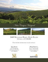
Nuns Canyon Vineyard
Nuns Canyon Vineyard - V&E Properties
Nuns Canyon Vineyard - V&E Properties

You also want an ePaper? Increase the reach of your titles
YUMPU automatically turns print PDFs into web optimized ePapers that Google loves.
Custom Soil Resource Report<br />
have similar use and management requirements. The delineation of such segments<br />
on the map provides sufficient information for the development of resource plans. If<br />
intensive use of small areas is planned, however, onsite investigation is needed to<br />
define and locate the soils and miscellaneous areas.<br />
An identifying symbol precedes the map unit name in the map unit descriptions. Each<br />
description includes general facts about the unit and gives important soil properties<br />
and qualities.<br />
Soils that have profiles that are almost alike make up a soil series. Except for<br />
differences in texture of the surface layer, all the soils of a series have major horizons<br />
that are similar in composition, thickness, and arrangement.<br />
Soils of one series can differ in texture of the surface layer, slope, stoniness, salinity,<br />
degree of erosion, and other characteristics that affect their use. On the basis of such<br />
differences, a soil series is divided into soil phases. Most of the areas shown on the<br />
detailed soil maps are phases of soil series. The name of a soil phase commonly<br />
indicates a feature that affects use or management. For example, Alpha silt loam, 0<br />
to 2 percent slopes, is a phase of the Alpha series.<br />
Some map units are made up of two or more major soils or miscellaneous areas.<br />
These map units are complexes, associations, or undifferentiated groups.<br />
A complex consists of two or more soils or miscellaneous areas in such an intricate<br />
pattern or in such small areas that they cannot be shown separately on the maps. The<br />
pattern and proportion of the soils or miscellaneous areas are somewhat similar in all<br />
areas. Alpha-Beta complex, 0 to 6 percent slopes, is an example.<br />
An association is made up of two or more geographically associated soils or<br />
miscellaneous areas that are shown as one unit on the maps. Because of present or<br />
anticipated uses of the map units in the survey area, it was not considered practical<br />
or necessary to map the soils or miscellaneous areas separately. The pattern and<br />
relative proportion of the soils or miscellaneous areas are somewhat similar. Alpha-<br />
Beta association, 0 to 2 percent slopes, is an example.<br />
An undifferentiated group is made up of two or more soils or miscellaneous areas that<br />
could be mapped individually but are mapped as one unit because similar<br />
interpretations can be made for use and management. The pattern and proportion of<br />
the soils or miscellaneous areas in a mapped area are not uniform. An area can be<br />
made up of only one of the major soils or miscellaneous areas, or it can be made up<br />
of all of them. Alpha and Beta soils, 0 to 2 percent slopes, is an example.<br />
Some surveys include miscellaneous areas. Such areas have little or no soil material<br />
and support little or no vegetation. Rock outcrop is an example.<br />
11