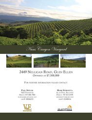
Nuns Canyon Vineyard
Nuns Canyon Vineyard - V&E Properties
Nuns Canyon Vineyard - V&E Properties

You also want an ePaper? Increase the reach of your titles
YUMPU automatically turns print PDFs into web optimized ePapers that Google loves.
Custom Soil Resource Report<br />
Map Unit Legend<br />
Sonoma County, California (CA097)<br />
Map Unit Symbol Map Unit Name Acres in AOI Percent of AOI<br />
RhD RED HILL CLAY LOAM, 2 TO 15<br />
PERCENT SLOPES<br />
RhE RED HILL CLAY LOAM, 15 TO 30<br />
PERCENT SLOPES<br />
RhF RED HILL CLAY LOAM, 30 TO 50<br />
PERCENT SLOPES<br />
30.0 23.1%<br />
22.9 17.7%<br />
30.1 23.2%<br />
RoG ROCK LAND 46.9 36.1%<br />
Totals for Area of Interest 130.0 100.0%<br />
Map Unit Descriptions<br />
The map units delineated on the detailed soil maps in a soil survey represent the soils<br />
or miscellaneous areas in the survey area. The map unit descriptions, along with the<br />
maps, can be used to determine the composition and properties of a unit.<br />
A map unit delineation on a soil map represents an area dominated by one or more<br />
major kinds of soil or miscellaneous areas. A map unit is identified and named<br />
according to the taxonomic classification of the dominant soils. Within a taxonomic<br />
class there are precisely defined limits for the properties of the soils. On the landscape,<br />
however, the soils are natural phenomena, and they have the characteristic variability<br />
of all natural phenomena. Thus, the range of some observed properties may extend<br />
beyond the limits defined for a taxonomic class. Areas of soils of a single taxonomic<br />
class rarely, if ever, can be mapped without including areas of other taxonomic<br />
classes. Consequently, every map unit is made up of the soils or miscellaneous areas<br />
for which it is named and some minor components that belong to taxonomic classes<br />
other than those of the major soils.<br />
Most minor soils have properties similar to those of the dominant soil or soils in the<br />
map unit, and thus they do not affect use and management. These are called<br />
noncontrasting, or similar, components. They may or may not be mentioned in a<br />
particular map unit description. Other minor components, however, have properties<br />
and behavioral characteristics divergent enough to affect use or to require different<br />
management. These are called contrasting, or dissimilar, components. They generally<br />
are in small areas and could not be mapped separately because of the scale used.<br />
Some small areas of strongly contrasting soils or miscellaneous areas are identified<br />
by a special symbol on the maps. If included in the database for a given area, the<br />
contrasting minor components are identified in the map unit descriptions along with<br />
some characteristics of each. A few areas of minor components may not have been<br />
observed, and consequently they are not mentioned in the descriptions, especially<br />
where the pattern was so complex that it was impractical to make enough observations<br />
to identify all the soils and miscellaneous areas on the landscape.<br />
The presence of minor components in a map unit in no way diminishes the usefulness<br />
or accuracy of the data. The objective of mapping is not to delineate pure taxonomic<br />
classes but rather to separate the landscape into landforms or landform segments that<br />
10