segment 4 - North Sydney Council
segment 4 - North Sydney Council
segment 4 - North Sydney Council

Create successful ePaper yourself
Turn your PDF publications into a flip-book with our unique Google optimized e-Paper software.
EA<br />
M A R K S<br />
S T<br />
SEGMENT 4<br />
SUSPENSION BRIDGE to CREMORNE JUNCTION<br />
ST<br />
KEELE<br />
ST<br />
ST<br />
TUCKER<br />
ST<br />
CARLOW<br />
ST<br />
BARINGA<br />
BAROONA<br />
Play<br />
CALBINA<br />
DAWSON ST<br />
GRAFTON<br />
AV<br />
Q U A R R Y<br />
S T<br />
B R I DG E -<br />
V I EW<br />
WEST<br />
AV<br />
ST<br />
Steps<br />
SEXTON<br />
PL<br />
5 .2m<br />
C lea r<br />
METCALFE<br />
ST<br />
St.Marys<br />
Nth<strong>Sydney</strong><br />
H<br />
J a c a rand a<br />
C o tt LD C C<br />
Marist<br />
College<br />
Nth Shore<br />
WEST<br />
P<br />
Nth <strong>Sydney</strong><br />
Leagues<br />
Club P<br />
P<br />
CAMMERAY<br />
2062<br />
H<br />
ST<br />
VALE<br />
MILLER<br />
N o r t h<br />
S y d n e y<br />
ST<br />
ST<br />
PALMER ABBOTT<br />
ROSALIND ST<br />
TRAFALGAR<br />
ST<br />
ERNEST<br />
RODBOROUGH<br />
W o o lworths<br />
AMHERST ST<br />
AV<br />
MACARTHUR<br />
Crows Nest College<br />
AV<br />
Nth <strong>Sydney</strong><br />
Boys<br />
High<br />
School<br />
FREDBEN<br />
EDWIN<br />
ST<br />
L A<br />
H A R D E N<br />
TARELLA AV<br />
PL<br />
FIG TREE LA<br />
Private access<br />
<strong>North</strong><br />
<strong>Sydney</strong><br />
Oval<br />
‘Billy Blue’<br />
P<br />
RD<br />
BBQ<br />
BEL<br />
L A NE LANE<br />
W 69 W 60<br />
W 68<br />
LANE<br />
<strong>North</strong>bridge<br />
Village<br />
H<br />
CLIFF<br />
CAMBRIDGE<br />
ST<br />
A B B O T T ST<br />
ABBOTT LA<br />
ST<br />
ROSALIND<br />
BARDSLEY<br />
GDNS<br />
NORTHBRIDGE<br />
2063<br />
H<br />
P<br />
L A<br />
C A M MER-<br />
-AY GAL<br />
P L<br />
ST<br />
MILLER<br />
P<br />
IXION<br />
LA<br />
L I L L I S<br />
ST<br />
Play<br />
NTH<br />
Bon<br />
Andrews<br />
SYDNEY Oval<br />
2060<br />
St. Leonards<br />
Park<br />
N h S d<br />
ST<br />
P<br />
AV<br />
RALEIGH<br />
ANZAC AV<br />
LYTTON<br />
ST<br />
ST<br />
BELLEVUE<br />
APPLETON<br />
LA<br />
PINE<br />
MARANA<br />
ST<br />
C L I F F<br />
FREEWAY<br />
EUROKA<br />
AV<br />
NORTH<br />
CARTER<br />
Moodie<br />
Lane<br />
Reserve<br />
FA L C O N ST EX IT<br />
GUNYAH<br />
ST<br />
RD<br />
AV<br />
COLIN<br />
LUMSDEN<br />
CA MMERA Y AV<br />
ST<br />
MOODIE<br />
L A N E<br />
W 5 7<br />
W 56<br />
LANE<br />
THE<br />
MORDEN<br />
MOODIE<br />
L A<br />
ST<br />
BLIGH<br />
UPPER<br />
ST<br />
STREET<br />
ULRIC<br />
LA<br />
24 H O UR B US LA NE<br />
WYAGDON<br />
ST<br />
McINTOSH<br />
LA<br />
Merlin<br />
St. Res<br />
NORTH<br />
ROSE<br />
AV AV T<br />
CLIFF<br />
MERLIN ST<br />
BENT<br />
TUNKS<br />
RD<br />
RD<br />
LOWER C L IFF<br />
B O UL EVA R D E<br />
CAIRO<br />
ST<br />
ECHO<br />
BELLS<br />
AV<br />
L A N E W 58<br />
LANE W55<br />
N o rth <strong>Sydney</strong> Circle W a lk<br />
ST<br />
ST<br />
ORISSA<br />
LA<br />
ST<br />
WILSON<br />
WARRINGA RD<br />
WA R R ING A RD<br />
9<br />
Clubhouse<br />
P<br />
MERLIN<br />
NEUTRAL<br />
BAY<br />
2089<br />
Wyagdon<br />
Street<br />
Res<br />
NAMOI<br />
MALACOOTA<br />
RD<br />
ULRIC<br />
R O W L I S O N PDE<br />
ST<br />
ST<br />
EAST<br />
AV<br />
ARKLAND<br />
St.Marks<br />
Ang<br />
SAILORS BAY RD<br />
Coachwood<br />
Forest<br />
F o u r Figs<br />
P a rk<br />
Tarella<br />
Stables<br />
TAFE NSW<br />
<strong>North</strong>ern <strong>Sydney</strong><br />
Institute<br />
N o r t h<br />
S h o r e<br />
Baptist Church<br />
& Preschool<br />
‘Fatty’ Dawson<br />
Ruins 1870<br />
WARRINGAH<br />
MILLER<br />
H a re<br />
K r ishn a<br />
Munro<br />
Park<br />
Suspension Bridge<br />
at <strong>North</strong>bridge<br />
(January 1892)<br />
Tunks Park<br />
West<br />
IN<br />
Music<br />
Shell<br />
<strong>Council</strong><br />
Depot<br />
Falcon<br />
Lodge<br />
STRATHALLEN<br />
Belgian<br />
Beer<br />
Cafe<br />
ST MILLER<br />
5.2m<br />
clear<br />
Nth Syd An z a c<br />
M e m l Cl & Ca m e ray<br />
Wm n s Bo w l Cl<br />
ST<br />
P r iva te<br />
a c c e s s<br />
FALCON<br />
<strong>North</strong>bridge<br />
Cammeray<br />
Public<br />
School<br />
C a m m e ray<br />
G d n s<br />
24 Hour<br />
Fuel<br />
AMHERST<br />
Tennis<br />
Police<br />
& Comm<br />
Yth Club<br />
Anzac<br />
Park<br />
Uniting<br />
Steps<br />
Skate<br />
Ramp<br />
Chimney<br />
St.Leonards Park<br />
AV<br />
ST<br />
MILLER<br />
Memorial<br />
Clock Tower<br />
Sub<br />
Station<br />
Steps<br />
All Saints<br />
Ang<br />
ST<br />
St.Philip Neri<br />
Cath Sch & Ch<br />
Tunks Park<br />
FWY<br />
ST<br />
Ang Media<br />
TV & Radio<br />
ST<br />
ST<br />
AVON<br />
LA<br />
WARWICK AV<br />
BYRNES<br />
CT<br />
CARMEL<br />
WOONONA<br />
ST<br />
AV<br />
AV<br />
CURRA-<br />
WANG<br />
ST<br />
SHORT<br />
LA<br />
TILEY<br />
AV<br />
FALCON<br />
ST<br />
K.Bolton LO<br />
GR E E N S<br />
RD<br />
LANE LANE<br />
W52<br />
ST<br />
W 51<br />
LANE W53<br />
LANE<br />
Falcon<br />
Memorial<br />
Playing Fields<br />
Steps<br />
Green<br />
Park<br />
CAMMERAY<br />
GOLF CLUB<br />
ERNEST<br />
Parkview<br />
Tennis<br />
Club<br />
CAMMERAY<br />
Cammeray<br />
Park<br />
Camm eray<br />
Croquet<br />
Club<br />
Cammeray<br />
Tennis<br />
Club<br />
MILITARY<br />
ST<br />
PINE<br />
LAYCOCK<br />
ST<br />
Alex Ma n o o g ian<br />
C u ltural Cen tre<br />
Y E O ST<br />
IER<br />
ST<br />
ST<br />
NARANI<br />
ST<br />
WATSON<br />
ST<br />
HARDIE<br />
V ER NO N<br />
ST<br />
EAST<br />
WERINGA AV<br />
DR<br />
PARK AV<br />
BROTHERS<br />
OAKS<br />
W 54<br />
Sports<br />
Field<br />
Play<br />
Play<br />
Scouts<br />
Kendall<br />
Comm Ctr<br />
N o rthb ridg e<br />
P rima ry Sc h o l<br />
AV<br />
STRATFORD<br />
ST<br />
P riva te<br />
a c c e s s<br />
G a teway Cou rt<br />
YEO<br />
ST<br />
CR<br />
CR<br />
STRATFORD<br />
FALL ST<br />
CAMMERAY<br />
2062<br />
CARTER<br />
RD<br />
ST<br />
ALAN<br />
EARLE ST<br />
GRASMERE<br />
SUTHERLAND<br />
COMO LA<br />
AV<br />
Synagogue<br />
GROSVENOR<br />
L A<br />
CHEAL LA<br />
r.o.w<br />
Neutral<br />
Bay<br />
Pub<br />
Sch<br />
ST<br />
RD<br />
CO W D R O Y<br />
ST<br />
LAMBERT<br />
ST<br />
LA<br />
VIEW<br />
ST<br />
RD<br />
Subway<br />
MILITARY<br />
P<br />
O L IVE L A<br />
Fire<br />
S tn<br />
18<br />
JOHNSTON<br />
AV<br />
YOUNG<br />
ST<br />
May<br />
G ibbs<br />
ST<br />
ST<br />
LA<br />
GROSVENOR<br />
P l<br />
U n tg<br />
& St.<br />
J o h n s<br />
CAMMERAY<br />
<strong>North</strong><br />
Cremorne<br />
Neutral Bay P<br />
Junction<br />
MAY<br />
P<br />
RD<br />
L A<br />
W ool-<br />
-worths MILITARY<br />
RD<br />
ST<br />
o m inos<br />
MILITA R Y<br />
L A<br />
E R S<br />
W<br />
AV<br />
WINSTON<br />
CHURCHILL CR<br />
GRASMERE GRASMERE LA<br />
B u s De p o t<br />
B ig Bear<br />
Shopping<br />
Centre<br />
Jetty<br />
P<br />
Boat Ramp<br />
3 lane concrete<br />
Bryce<br />
Mortlock<br />
Res<br />
BEN BOYD<br />
LA<br />
SUTHERLAND<br />
LA<br />
GROSVENOR<br />
BEN BOYD<br />
Tennis<br />
NORTHBRIDGE<br />
NORTHBRIDGE<br />
GOLF GOLF CLUB<br />
CLUB<br />
BELGRAVE<br />
LA<br />
YOUNG<br />
YOUNG<br />
Cammeray<br />
Marina<br />
LA<br />
ST<br />
RD<br />
COOPER<br />
Steps<br />
LA<br />
L A<br />
ST<br />
Neu tral<br />
Bay<br />
Villag e<br />
YEO<br />
Salt Pan Ck<br />
P<br />
W<br />
AV RD<br />
DENOS<br />
MATOR A<br />
Primrose Park<br />
Arts & Crafts Ctr<br />
YOUNG<br />
B E N E L O N G LA<br />
GRASMERE<br />
LITTLE<br />
YOUNG<br />
ST<br />
GRASMERE RD<br />
OLD<br />
MARTEN<br />
LA<br />
WATERS<br />
Nor t h<br />
Sports<br />
Field<br />
LA<br />
LA<br />
LA<br />
BENELONG<br />
LA<br />
BENELONG RD<br />
WATERS<br />
RANGERS<br />
Syd n ey<br />
Grasmere<br />
Res<br />
ST<br />
LA<br />
LA<br />
ST<br />
Watersleigh<br />
Pk<br />
RD<br />
LA<br />
W A T E R S LEIGH<br />
B E NELON G<br />
WATERS<br />
AUBREY<br />
C i r c l e W a l k<br />
ST<br />
LAGUNA<br />
RD<br />
CREMORNE<br />
2090<br />
BRIGHTMORE<br />
RD<br />
WINNIE<br />
ILLILIWA<br />
MONFORD<br />
PL<br />
Telephone<br />
Exch.<br />
HA M PD E N AV<br />
MURDOCH<br />
MIOWERA RD<br />
War<br />
Memorial<br />
Tennis Segment P 4 - CIRCLE WALK<br />
Clubhouse<br />
MAIN ROUTE<br />
ADJOINING MAIN ROUTES NORTHBRIDGETOILETS<br />
RETURN ROUTE<br />
18<br />
2063<br />
VIEWPOINTS<br />
Sea<br />
Norman<br />
Scouts<br />
Landers<br />
Library<br />
Guides<br />
ADJOINING RETURN ROUTES<br />
0 100<br />
<strong>North</strong>bridge<br />
200 300 400 500<br />
0<br />
Oval<br />
Scale metres<br />
Tennis<br />
Basketball<br />
Locked<br />
John<br />
Roche Play<br />
Park<br />
PARK<br />
RD<br />
M e d C tr<br />
AV<br />
a<br />
RD<br />
ST<br />
SAILORS BAY<br />
GRAFTON<br />
ST<br />
NORTHBRIDGE<br />
GOLF CLUB<br />
Cricket<br />
Net<br />
Playing<br />
Fields<br />
Primrose Park<br />
EARLE<br />
BELGRAVE<br />
YOUNG<br />
B I<br />
W OLL O M<br />
Folly<br />
Point<br />
W O NGA<br />
GERARD<br />
RD<br />
REYNOLDS<br />
ST<br />
LANE W47<br />
Pk<br />
RD<br />
W E EMA L A<br />
T O BRUK<br />
LITTLE<br />
WONGA<br />
RD<br />
P<br />
Tricycle<br />
Track<br />
Brightmore<br />
Reserve<br />
St.Pe ter s<br />
An g .<br />
Harley<br />
Nursing Home<br />
Hlth<br />
C tr<br />
C R A N B R O OK<br />
T I O N<br />
D O R SET<br />
L A<br />
AV<br />
HOLT<br />
CRAN-<br />
-BROOK<br />
LA<br />
<strong>Sydney</strong><br />
Ch.ofEngland<br />
Co-Ed<br />
Grammar Sch<br />
‘Redlands’<br />
Basketball<br />
Re d l a<br />
H o<br />
ALLISTER<br />
RD<br />
RD<br />
SAMORA<br />
AV<br />
LLOYD AV<br />
ELLALONG<br />
PL<br />
TOBRUK AV<br />
PARRAWEEN<br />
Mc<br />
Donalds<br />
<strong>Sydney</strong><br />
C of E Co-Ed<br />
Grammar<br />
H The<br />
Cheal<br />
Oaks<br />
Sch<br />
Bus<br />
Pk<br />
’Redlands’<br />
Weaver<br />
Terminus<br />
P<br />
(Buses<br />
Only)<br />
ST<br />
ST<br />
Play<br />
Play<br />
G rasmere<br />
Childrens Pk<br />
ST<br />
RD<br />
Salt Pan Ck<br />
<strong>North</strong>bridge<br />
Park<br />
GERARD<br />
Substation<br />
AV<br />
ST<br />
B E N E L O NG<br />
ST<br />
ADA ST<br />
PALING<br />
ST<br />
Cremo rne<br />
Plaz a<br />
RD<br />
RD<br />
E L L A LONG<br />
R I C H M O N D<br />
L E V ICK<br />
C remo rne<br />
A rcade<br />
C R A NBRO O K<br />
AV<br />
Elizabeth<br />
Park<br />
C O OL AW I N<br />
COOLAWIN<br />
RD<br />
LA<br />
AV<br />
LO DGE<br />
Steps<br />
FIFTH<br />
P<br />
RD<br />
ST<br />
POFFORTH<br />
RD<br />
ST<br />
S P E N CE R<br />
NORTHBRIDGE<br />
2063<br />
P<br />
Early C’hood<br />
Ctr<br />
H<br />
LODGE<br />
RD<br />
RYRIES PDE<br />
MONTAGUE<br />
CREMORNE<br />
2090<br />
P<br />
H ALLS T R O M<br />
Cremorne<br />
Town Ctr<br />
HOLT<br />
BLOXSOME<br />
SDN<br />
CL<br />
RYRIES<br />
RD<br />
RD<br />
GERARD LA<br />
RD<br />
RD<br />
Play<br />
AV<br />
ST<br />
Ha y d e n Orph e u m<br />
P icture Pa lac e<br />
C A B R A M AT TA<br />
Cremorne<br />
Veterinary<br />
Hospital<br />
SHELLBANK<br />
PDE<br />
Lodge Rd<br />
Playground<br />
S U T TON<br />
PL<br />
L O D G E<br />
LA<br />
C A R TREF<br />
LA<br />
PDE<br />
ELLALONG<br />
FERNHURST<br />
AV<br />
DAVIDSON<br />
PDE<br />
AV<br />
BARISTON<br />
AV<br />
P R O S PE C T<br />
LANGLEY<br />
H lth<br />
C tr<br />
Concierge<br />
Apts<br />
ST<br />
Stormwater<br />
Trap<br />
Copyright c Sydway Publishing Pty Ltd 2006<br />
Play<br />
Brothers<br />
Memorial<br />
Park<br />
ST<br />
AV<br />
L A N G L E Y<br />
P L<br />
AV<br />
RD<br />
MACPHERSON<br />
SPENCER<br />
TWIN<br />
TOWERS<br />
WALK<br />
STUART<br />
WLK<br />
BRIERLY ST<br />
S H E L L B ANK AV<br />
MOSMAN<br />
RANGERS R<br />
C a rtref<br />
P a rk<br />
WYONG<br />
RD<br />
ST<br />
MAC P HE R SON<br />
PRINCE ST<br />
GLOVER<br />
LINDSAY<br />
CABRAMATTA<br />
Fig Tree<br />
Point<br />
ST<br />
ERITH<br />
<strong>North</strong> <strong>Sydney</strong> Circle Walk<br />
MILITARY<br />
GLOVER<br />
LA<br />
2088<br />
ST<br />
AWABA<br />
AV<br />
Water<br />
Board<br />
J U L I A N<br />
ST<br />
CONGEWOI L<br />
ZAHEL<br />
Middle<br />
Harbour<br />
Public<br />
School<br />
M a n o r s of<br />
M o s m a n<br />
R e tire men t<br />
Villag e<br />
HALE<br />
ST<br />
Cremorne<br />
Junction<br />
Chester Hse<br />
Quakers H<br />
Le Ga y<br />
Brereton<br />
Pk<br />
Boatshed<br />
Moorings<br />
LA<br />
B<br />
BRAY ST<br />
OURIMBAH<br />
RD<br />
LA<br />
MACKIE<br />
HALE<br />
RD MELROS<br />
2 4 h r<br />
S e rv. Stn.<br />
PRINCE<br />
BELMONT<br />
LANG<br />
Med<br />
Ctr<br />
Mosman<br />
Baptist<br />
MOSMAN<br />
2088<br />
LA<br />
B<br />
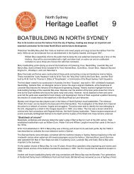
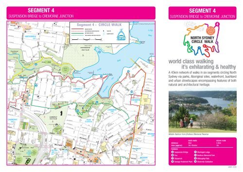
SEGMENT 4<br />
SUSPENSION BRIDGE to CREMORNE JUNCTION<br />
3<br />
NORTH SYDNEY<br />
CIRCLE WALK<br />
2 6<br />
1<br />
world class walking<br />
it’s exhilarating & healthy<br />
A 45km network of walks in six <strong>segment</strong>s circling <strong>North</strong><br />
<strong>Sydney</strong> via parks, Aboriginal sites, waterfront, bushland<br />
and urban streetscapes encompassing features of both<br />
natural and architectural heritage.<br />
Middle Harbour from Brothers Memorial Reserve<br />
main route return route<br />
distance 5km 3.5km<br />
time (approx)<br />
features<br />
1hr 45mins 1hr<br />
A Suspension Bridge E Warringah Lodge<br />
B Tree F Brothers Memorial Park<br />
C Shipwreck G Willoughby Falls<br />
D Sewage Treatment Plant H<br />
Electricity Substation<br />
4<br />
5<br />
JUNE 2006
SEGMENT 4<br />
SUSPENSION BRIDGE to CREMORNE JUNCTION<br />
Start Main Route<br />
The walk begins at the Suspension Bridge A (see Segment 3 for<br />
background) and meanders along past the interestingly sited and<br />
architecturally varied houses of The Boulevard and Rowlinson Parade.<br />
At Vernon Street drop down via Brothers Avenue for a visit to Tunks<br />
Park. The park’s name recognises William Tunks, St Leonards Mayor<br />
from 1867 until his death in 1883 and a conservationist greatly<br />
concerned about creating public reserves. The Park was a construction<br />
centre for the recently completed <strong>North</strong>side Storage Tunnel at Lane<br />
Cove and Scott’s Creek to <strong>North</strong> Head which is designed to prevent<br />
wet weather sewage overflowing into the Harbour.<br />
Leave Tunks Park, climb Brothers Avenue past the playground and<br />
turn left into Vernon Street at the ‘No Entry’ sign. Water glimpses and<br />
then houses make this a pleasant if steady climb. Continue left into<br />
Cowdroy Avenue and up to Cammeray Road. At this junction, note the<br />
tree B in the road centre and its sad story. Barcroft Boake, the 26<br />
year-old surveyor son of a Milsons Point photographer, was a highly<br />
regarded bush poet whose best-known poem is Out Where the Dead<br />
Men Lie. Out of work in the economic depression of 1892 and further<br />
depressed by a death in the family and the failure of his father’s<br />
business, he left Milsons Point for a walk in the dense bushland of the<br />
Cammeray peninsula, a favourite spot. Eight days later he was found<br />
by workmen. He had hanged himself from the gum tree with his<br />
stockwhip. The tree survived him by almost a century but had to be<br />
replaced in recent years.<br />
Continue downhill to Folly Point, a delightful spot for a break. Older<br />
maps often show this as Cammeray Point with Folly Point being at<br />
Primrose Park. Various unsubstantiated reasons are offered for the<br />
curious name but it could well have been named by Captain Charles<br />
McKinnon, commander of the explosives hulks moored near Seaforth<br />
before the Bantry Bay Depot was constructed. Look left across Long<br />
Bay to Salt Pan Creek where the skeleton of a shipwreck C protrudes<br />
from the water below <strong>North</strong>bridge Golf Course. A number of boats<br />
were scuttled in this bay including the Italia (1906) and the Coraki<br />
(1946). To your right is Willoughby Bay. In April 1877 there was only<br />
bushland here and it was here that Melbourne born showman, Henri<br />
L'Estrange outdid the great Blondin by crossing on a 433 metre tight<br />
rope suspended 105 metres above the water. Below, thousands of<br />
paying customers cheered from ferries. Now return slightly back<br />
uphill, turning left beyond the houses to take the bushwalk across and<br />
then downhill over a canal bridge to Primrose Park.<br />
In the nineteenth century, the Primrose Park area was a recognised<br />
beauty spot with a large inlet fed by the once impressive Willoughby<br />
Falls, which now trickle from below Grafton Street. However, Primrose<br />
Park’s current sweet-smelling name notwithstanding, the site was the<br />
Folly Point sewage treatment plant D from 1892 to 1926. Most of<br />
its large flat area was filled with trickling filter beds, which in<br />
operation looked rather like a vegetable farm with rows of sprinklers -<br />
but did not smell like one. There was also a pump house with a tall<br />
chimney, settling and sludge tanks, a small tramway and canals.<br />
Significant elements remain, the original covered settling tanks now<br />
sporting tennis courts. Explore the area now if you wish, or on the<br />
return leg. By 1926 population growth had overwhelmed the system<br />
and it was closed and replaced by the ocean outfall system. In place<br />
of the sewage farm, Primrose Park was dedicated in 1930, and<br />
named after the then Mayor of <strong>North</strong> <strong>Sydney</strong>. It is now a thriving<br />
community arts and craft centre.<br />
Cross the Park waterfront to one-way Wonga Road, and walking along<br />
to the left, climb it almost to Lodge Road to where the road widens<br />
and take the small loop left near the 25kph sign to the 1879 mansion<br />
Warringah Lodge E , the first house built in the area. Further uphill<br />
turn left into Ryries Parade, noting the fern-filled waterfall in the first<br />
dip. At Wyong Road, the <strong>North</strong> <strong>Sydney</strong> Boundary is met again but look<br />
across the street to the house Shellbank before heading uphill to the<br />
right and into Macpherson Street.<br />
The quiet street of largely Federation houses is swamped by traffic<br />
once the Ourimbah Road lights are reached, so turn right into little<br />
Davidson Parade and follow it around to the Bariston Avenue walkway<br />
leading to Fifth Avenue and wonderful Middle Harbour views from<br />
Brothers Memorial Park F before retracing your steps and<br />
continuing along Fifth Avenue to Montague Road and back to<br />
Macpherson Street.<br />
Two short blocks bring you to Prospect Avenue (and there is one at its<br />
end), turn into it and then left immediately into Langley Avenue.<br />
This is almost the end. At the next intersection, a left turn at Gerard<br />
Street followed by a right at Macpherson brings you within a hundred<br />
metres of Cremorne Junction at Military Road and at the start of<br />
Segment 5.<br />
Start Return Route<br />
To return to the Suspension Bridge, walk back to the Langley/Gerard<br />
intersection, turn left into Gerard Lane which soon hooks left and runs<br />
downhill to Benelong Road. Turn right here, right again at Reynolds<br />
Street and then left into Levick Street. Cross the intersection at<br />
Levick’s end to the bush path which leads down in sometimes steep<br />
steps to Brightmore Reserve with its interesting driver training track.<br />
Primrose Park is across Wonga Road/Young Street. Cross to it and<br />
turn left, walking through the park to the old plant buildings and the<br />
tennis courts atop them. Walk around the left (southern) edge of the<br />
courts to pick up a zigzag track behind them that leads up to Grafton<br />
Street and a glimpse of Willoughby Falls G<br />
.<br />
Take a right along Grafton Street and then left along Cammeray Road.<br />
This passes between Cammeray Park and Golf Course and leafy<br />
Green Park, to Amherst Street. At Bellevue Street, turn right to follow<br />
this quieter alternative to Miller Street to its end past Cammeray Public<br />
School and the wooden cottages opposite. At the end is the interesting<br />
converted 1915 electricity substation H (The <strong>North</strong> Shore’s first)<br />
designed to stylistically complement the Suspension Bridge which sits<br />
attractively below. Take the left-hand steps down to Pine Street and<br />
then cross to <strong>North</strong> Avenue where a path leads to the Suspension<br />
Bridge A .<br />
Written and researched by the Walking Volunteers. For further <strong>North</strong><br />
<strong>Sydney</strong> and regional walking materials go the Customer Service<br />
Centre, Stanton Library, or www.northsydney.nsw.gov.au click<br />
‘recreation’ and www.planning.nsw.gov.au/harbour click ‘Walking<br />
<strong>Sydney</strong> Harbour’. Photographs Graham Spindler.