

Lava cascade in Thunderbolt Distributary of Labyrinth Cave system
report
report

You also want an ePaper? Increase the reach of your titles
YUMPU automatically turns print PDFs into web optimized ePapers that Google loves.
es <strong>of</strong> plaster clog its cont<strong>in</strong>uation completely.<br />
Near-Surface Nature <strong>of</strong> the<br />
Headquarters and Labyr<strong>in</strong>th Area Tubes<br />
From our <strong>in</strong>vestigations <strong>of</strong> these<br />
Headquarters area lava tubes, one conclusion<br />
needs to be emphasized: all <strong>of</strong><br />
them described so far, with the possible<br />
exception <strong>of</strong> the eastern distributary <strong>of</strong><br />
Mushpot <strong>Cave</strong>, are small near-surface<br />
tubes. If you compare map 1 and map 2<br />
(pl. 1), it appears at first glance that all<br />
<strong>of</strong> the lava active <strong>in</strong> mak<strong>in</strong>g the remarkably<br />
extensive bifurcat<strong>in</strong>g caves <strong>of</strong> the<br />
Labyr<strong>in</strong>th area was f<strong>in</strong>ally funneled<br />
downstream <strong>in</strong>to the t<strong>in</strong>y s<strong>in</strong>gle tube<br />
conta<strong>in</strong><strong>in</strong>g the <strong>Thunderbolt</strong> entrance.<br />
This <strong>in</strong>terpretation is, <strong>of</strong> course, nonsense.<br />
What is miss<strong>in</strong>g <strong>in</strong> such an analysis<br />
is the fact that nearly all the tubes <strong>in</strong><br />
both Labyr<strong>in</strong>th and Headquarters areas<br />
disappear downstream because lava<br />
filled to their ro<strong>of</strong>s; thus, further trac<strong>in</strong>g<br />
<strong>of</strong> them is impossible. Only the parts that<br />
have dra<strong>in</strong>ed out after cessation <strong>of</strong> volcanism<br />
can be entered, mapped, and<br />
studied.<br />
Unquestionably, deep beneath the<br />
Headquarters area are scores <strong>of</strong> tubes<br />
filled to their ro<strong>of</strong>s with lava. One<br />
example we studied is the eastern distributary<br />
<strong>of</strong> Mushpot <strong>Cave</strong>, where 70ft<br />
<strong>of</strong> the ro<strong>of</strong> <strong>of</strong> a deeper, now-filled tube<br />
is visible. We also traced Mushpot, parts<br />
<strong>of</strong> <strong>Lava</strong> Brook, and Arch <strong>Cave</strong>s downstream<br />
to where they are filled with<br />
congealed lava.<br />
Well over 85 percent <strong>of</strong> the deep<br />
underground lava "plumb<strong>in</strong>g" <strong>system</strong> <strong>in</strong><br />
<strong>Lava</strong> Beds National Monument was<br />
filled with congealed lava and is therefore<br />
<strong>in</strong>accessible. But accidents <strong>of</strong> various<br />
k<strong>in</strong>ds have, <strong>in</strong> places, preserved<br />
short sections <strong>of</strong> <strong>in</strong>tact lava tubes. Examples<br />
<strong>of</strong> large remnants <strong>in</strong> the monument<br />
are Crystal, Craig, and Post Office<br />
<strong>Cave</strong>s. Indian Well (map 1, pl. 1) and<br />
Sent<strong>in</strong>el <strong>Cave</strong>s (map 7, pl. 2) are easily<br />
accessible small remnants on a l<strong>in</strong>e upstream<br />
with Ovis <strong>Cave</strong>, Crystal <strong>Cave</strong>,<br />
and the deep tubes underly<strong>in</strong>g Natural<br />
Bridge. Downstream their extension can<br />
be traced by breakdowns at the entrances<br />
<strong>in</strong>to Post Office and Silver <strong>Cave</strong>s and<br />
eastward to a possible junction with<br />
Craig <strong>Cave</strong>.<br />
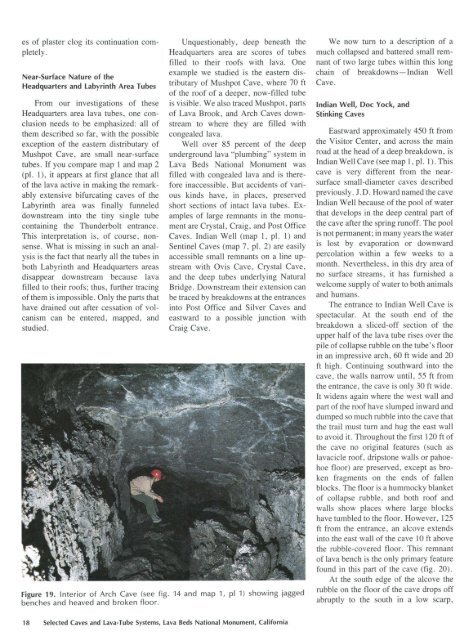
Figure 19. Interior <strong>of</strong> Arch <strong>Cave</strong> (see fig. 14 and map 1, pi 1) show<strong>in</strong>g jagged<br />
benches and heaved and broken floor.<br />
We now tum to a description <strong>of</strong> a<br />
much collapsed and battered small remnant<br />
<strong>of</strong> two large tubes with<strong>in</strong> this long<br />
cha<strong>in</strong> <strong>of</strong> breakdowns-Indian Well<br />
<strong>Cave</strong>.<br />
Indian Well, Doc Yock, and<br />
St<strong>in</strong>k<strong>in</strong>g <strong>Cave</strong>s<br />
Eastward approximately 450 ft from<br />
the Visitor Center, and across the ma<strong>in</strong><br />
road at the head <strong>of</strong> a deep breakdown, is<br />
Indian Well <strong>Cave</strong> (see map 1, pl. 1). This<br />
cave is very different from the nearsurface<br />
small-diameter caves described<br />
previously. J.D. Howard named the cave<br />
Indian Well because <strong>of</strong> the pool <strong>of</strong> water<br />
that develops <strong>in</strong> the deep central part <strong>of</strong><br />
the cave after the spr<strong>in</strong>g run<strong>of</strong>f. The pool<br />
is not permanent; <strong>in</strong> many years the water<br />
is lost by evaporation or downward<br />
percolation with<strong>in</strong> a few weeks to a<br />
month. Nevertheless, <strong>in</strong> this dry area <strong>of</strong><br />
no surface streams, it has furnished a<br />
welcome supply <strong>of</strong> water to both animals<br />
and humans.<br />
The entrance to Indian Well <strong>Cave</strong> is<br />
spectacular. At the south end <strong>of</strong> the<br />
breakdown a sliced-<strong>of</strong>f section <strong>of</strong> the<br />
upper half <strong>of</strong> the lava tube rises over the<br />
pile <strong>of</strong> collapse rubble on the tube's floor<br />
<strong>in</strong> an impressive arch, 60 ft wide and 20<br />
ft high. Cont<strong>in</strong>u<strong>in</strong>g southward <strong>in</strong>to the<br />
cave, the walls narrow until, 55 ft from<br />
the entrance, the cave is only 30ft wide.<br />
It widens aga<strong>in</strong> where the west wall and<br />
part <strong>of</strong> the ro<strong>of</strong> have slumped <strong>in</strong>ward and<br />
dumped so much rubble <strong>in</strong>to the cave that<br />
the trail must tum and hug the east wall<br />
to avoid it. Throughout the first 120ft <strong>of</strong><br />
the cave no orig<strong>in</strong>al features (such as<br />
lavacicle ro<strong>of</strong>, dripstone walls or pahoehoe<br />
floor) are preserved, except as broken<br />
fragments on the ends <strong>of</strong> fallen<br />
blocks. The floor is a hummocky blanket<br />
<strong>of</strong> collapse rubble, and both ro<strong>of</strong> and<br />
walls show places where large blocks<br />
have tumbled to the floor. However, 125<br />
ft from the entrance, an alcove extends<br />
<strong>in</strong>to the east wall <strong>of</strong> the cave 10 ft above<br />
the rubble-covered floor. This remnant<br />
<strong>of</strong> lava bench is the only primary feature<br />
found <strong>in</strong> this part <strong>of</strong> the cave (fig. 20).<br />
At the south edge <strong>of</strong> the alcove the<br />
rubble on the floor <strong>of</strong> the cave drops <strong>of</strong>f<br />
abruptly to the south <strong>in</strong> a low scarp,<br />
18 Selected <strong>Cave</strong>s and <strong>Lava</strong>-Tube Systems, <strong>Lava</strong> Beds National Monument, California


