

GUIDEBOOK
wirey5prpznidqx
wirey5prpznidqx

You also want an ePaper? Increase the reach of your titles
YUMPU automatically turns print PDFs into web optimized ePapers that Google loves.
PARQUE NACIONAL CAJAS<br />
Av. 27 de Febrero<br />
Av. 27 de Febrero<br />
MARIA<br />
AUXILIADORA<br />
Ca le Larga<br />
Pio Bravo<br />
RIO YANUNCAY<br />
CRISTO<br />
REY<br />
Av. Florencia Astudi lo<br />
Presidente Cordova<br />
Av. de las Americas<br />
Av. Heroes de Verdeloma<br />
Rafael Maria Arizaga<br />
BARRIAL<br />
BLANCO<br />
Vega Muñoz<br />
Av. 24 de Mayo<br />
SAN BLAS<br />
Alfonso Malo<br />
LUIS<br />
CORDERO<br />
BANCO<br />
CENTRAL<br />
TOTORACOCHA<br />
ORATORIO<br />
DON BOSCO<br />
4. IMPLEMENTING THE HUL APPROACH<br />
The HUL Approach in Action<br />
The HUL approach requires us to take into account the local context of each historic city. Whilst this will<br />
result in different approaches to management for different cities, at a minimum six critical steps were<br />
recommended to facilitate the implementation of the HUL approach.<br />
B. THE SIX CRITICAL STEPS<br />
1. To undertake comprehensive surveys and mapping of the city’s natural, cultural and human resources;<br />
2. To reach consensus using participatory planning and stakeholder consultations on what values to<br />
protect for transmission to future generations and to determine the attributes that carry these values;<br />
3. To assess vulnerability of these attributes to socio-economic stresses and impacts of climate change;<br />
4. To integrate urban heritage values and their vulnerability status into a wider framework of city<br />
development, which shall provide indications of areas of heritage sensitivity that require careful<br />
attention to planning, design and implementation of development projects;<br />
5. To prioritize actions for conservation and development; and<br />
6. To establish the appropriate partnerships and local management frameworks for each of the<br />
identified projects for conservation and development, as well as to develop mechanisms for the<br />
coordination of the various activities between different actors, both public and private.<br />
(UNESCO, 2011)<br />
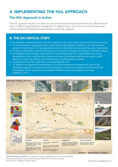
Reflexiones Temáticas: GEOLOGIA<br />
Escarpe fluvial del río<br />
Machángara en el<br />
interior del polígono<br />
industrial de Cuenca.<br />
La línea de<br />
vegetación coincide<br />
con la traza del<br />
escapre.<br />
Escarpes<br />
fluviales del río<br />
Tomebamba<br />
(flechas negras)<br />
y del Yanuncay<br />
(flechas<br />
blancas) en el<br />
centro de la<br />
ciudad.<br />
Convergen a lo<br />
largo de la Av.<br />
10 de Agosto<br />
hasta la Iglesia<br />
de la Virgen del<br />
Bronce en la Av.<br />
Solano.<br />
Escarpe de<br />
falla<br />
interrumpido<br />
y desdibujado<br />
por la acción<br />
erosiva de los<br />
ríos<br />
Tomebamba y<br />
Milchichig<br />
Altiplano resto<br />
de una antigua<br />
terraza aluvial de<br />
hace<br />
aproximadament<br />
e 1 Ma., afectada<br />
por cicatrices de<br />
deslizamiento<br />
(líneas rojas).<br />
1.- Geología y Geotecnia<br />
Av. Ordoñez Lazo<br />
Av. Unidad Nacional<br />
Av. Remigio Crespo<br />
SAN ROQUE<br />
Convencion del 45<br />
Av. 12 de Abril<br />
Av. Loja<br />
RIO TOMEBAMBA<br />
CONVENCION<br />
DEL 45<br />
EL VADO<br />
Miguel Velez<br />
Miguel Heredia<br />
Coronel Talbot<br />
MUSEO DEL<br />
SOMBRERON<br />
Av. de las Americas<br />
Estevez de Toral<br />
General Torres<br />
Juan Montalvo<br />
SAN FRANCISCO<br />
Tarqui<br />
Gran Colombia<br />
Padre Aguirre<br />
PARQUE<br />
CALDERON<br />
Benigno Malo<br />
Luis Cordero<br />
Presidente Borrero<br />
Av. Abelardo J. Andrade<br />
Hermano Miguel<br />
Mariano Cueva<br />
Mariscal Lamar<br />
Simon Bolivar<br />
Mariscal Sucre<br />
Gaspar Sangurima<br />
Altiplano resto<br />
divisoria de aguas<br />
entre los ríos<br />
Tomebamba y<br />
Yanuncay, a lo largo de<br />
la avenida 10 de<br />
Agosto. Señalar plaza<br />
de toros<br />
abierto por el hombre<br />
para la avenida Loja<br />
Av. Loja<br />
Juan Jarami lo<br />
Vargas Machuca<br />
Tomas Ordoñez<br />
Manuel Vega<br />
Av. Huayna Capac<br />
2.- Geomorfología<br />
Agustin Cueva<br />
Av. Federico Proaño<br />
Av. Fray Vicente Solano<br />
Av. del Estadio<br />
PARQUE DE<br />
LA MADRE<br />
Av. 12 de Abril<br />
Federico Malo<br />
RIO TOMEBAMBA<br />
Honorato Vasquez<br />
Alfonso Jerves<br />
Escarpes de falla en la circunvalación Sur (Tomada de http://www.eltiempo.com.ec).<br />
Av. 10 de Agosto<br />
ESTADIO<br />
Av. 12 de Abril<br />
Ca le Larga<br />
VIRGEN DE<br />
BRONCE<br />
Av. Fray Vicente Solano<br />
Av. 10 de Agosto<br />
Av. Roberto Crespo<br />
Av. Luis Moreno Mora<br />
Av. Jose Peralta<br />
Av. Francisco Moscoso<br />
Bajada de Todos Santos<br />
RIO TOMEBAMBA<br />
Av. Paucarbamba<br />
Las Herrerias<br />
Av. Don Bosco<br />
Altura de edificios<br />
Av. 24 de Mayo<br />
RIO TARQUI<br />
3.- Hidrología<br />
Av. 24 de Mayo<br />
EL VERGEL<br />
CIUDADELA<br />
TOMEBAMBA<br />
AUTOPISTA CUENCA - AZOGUES<br />
AUTOPISTA CUENCA - AZOGUES<br />
AUTOPISTA CUENCA - AZOGUES<br />
HIDROLOGIA:<br />
TOPOGRAFIA:<br />
GEOMORFOLOGIA:<br />
GEOLOGIA Y GEOTECNICA<br />
4.- Topografía<br />
Cuenca cuenta con cuatro rios, por lo<br />
tanto el suministro de agua en la época<br />
de los primeros pobladores estaba<br />
prácticamente asegurado.<br />
Primeros pobladores preferían asentarse<br />
en las lomas que rodean la olla de<br />
Cuenca probablemente por visibilidad<br />
y defensa<br />
La ciudad crece por la llanura aluvial de<br />
los cuatro ríos.<br />
Hoy no queda mucho espacio y la ciudad<br />
empieza a crecer por las laderas empinadas<br />
que la rodean.<br />
¿Qué variable controlará la distrib ción<br />
espacial en el futuro? ¿El vehículo?<br />
Los ríos Tarqui, Yanuncay, Tomebamba y<br />
Machángara y sus llanuras aluviales, pues<br />
son los agentes que fundamentalmente<br />
han modelado la zona de estudio.<br />
Lomas, resultado de la combinación<br />
estructura geológica y resistencia<br />
de ciertos materiales a la erosión.<br />
AHORA !! QUE OPINAN USTEDES ?<br />
"Now! What do you think?" A map about Cuenca's geology from the HUL application<br />
Visionary Conference community workshop, 8 May 2015, Cuenca, Ecuador.<br />
Source: PUH_C Research Project Team<br />
The HUL Guidebook | 13