
You also want an ePaper? Increase the reach of your titles
YUMPU automatically turns print PDFs into web optimized ePapers that Google loves.
INDUSTRYfocus<br />
Innovating in the Cloud<br />
Bentley Systems and Topcon join forces to advance cloud services for 'constructioneering'<br />
We looked at 'conceptioneering' in<br />
the last issue - now we are being<br />
introduced to<br />
'constructioneering'. Bentley appears to be<br />
pioneering a new method of describing<br />
the bringing together of a number of<br />
different disciplines to make a more<br />
valuable 'whole'.<br />
It's not an uncommon concept, as<br />
traditional construction activities such as<br />
architectural design, structural, MEP and<br />
environmental applications are all well<br />
integrated and capable of sharing models<br />
and data, improving efficiency and<br />
enhancing workflow processes. Bentley is<br />
taking the process one step further,<br />
though, by bringing together construction<br />
workflows that traditionally operate within<br />
their own environment - surveys,<br />
engineering design and construction -<br />
providing benefits not previously<br />
attainable.<br />
The recent Bentley Year in Infrastructure<br />
event in London was the perfect venue for<br />
launching the joint intentions of Bentley<br />
Systems and Topcon Positioning Group to<br />
connect their respective cloud services to<br />
promote the concept of<br />
constructioneering. Topcon is a world<br />
leader in positioning instruments for<br />
survey and construction, and for the use<br />
of GNSS (Global Navigation Satellite<br />
Systems) and robotics in the automatic<br />
positioning of construction equipment like<br />
graders, bulldozers and excavators.<br />
Adopting elements of each other's<br />
software solutions, Bentley Systems will<br />
offer ProjectWise CONNECT Edition users<br />
seamless access to Topcon's MAGNET<br />
Enterprises, whilst Topcon will incorporate<br />
Bentley's ContextCapture image<br />
processing for its mass data collection via<br />
unmanned aerial systems (UAS).<br />
A TWO-WAY PROCESS<br />
The symmetry between the two processes<br />
is quite satisfying. The construction site<br />
survey data - an accurate 3D model of the<br />
current conditions that includes both<br />
terrain and existing structures - is captured<br />
using Topcon UAV photogrammetry and<br />
laser scanners. This is then processed<br />
into engineering ready 3D reality meshes<br />
by ContextCapture software, where it<br />
becomes the basis of further engineering<br />
design and terrain development within<br />
Bentley's numerous applications.<br />
With the connection between Topcon's<br />
MAGNET cloud service and Bentley's<br />
ProjectWise CONNECT Edition Cloud<br />
established, the updated model can then<br />
be automatically conveyed to engineers<br />
engaged in construction processes in the<br />
field, with the digital engineering models<br />
feeding the 3D machine control that<br />
guides the construction machinery.<br />
Greg Bentley, CEO of Bentley Systems,<br />
explained the benefits quite clearly. "To<br />
date," he said, "surveying, engineering,<br />
and construction industries have<br />
separately advanced to 3D technologies.<br />
But unbelievably, until now, 3D models<br />
have been recreated - rather than reused -<br />
at each phase."<br />
He explained further, pointing out that<br />
engineers are now able to start from<br />
reality-captured surveys, and to update<br />
their digital engineering models<br />
throughout the construction process - a<br />
real-time bilateral process that provides<br />
construction workers with the latest<br />
construction model at all times. The joint<br />
cloud service innovations for constructing<br />
and improving roadways, which include<br />
as-built capture, are now enabling the<br />
highest level of workflow automation. This<br />
has to be compared to traditional<br />
workflows between design and<br />
construction in which data from survey<br />
and digital engineering models can be lost<br />
and inefficiently recreated.<br />
Constructioneering empowers engineers<br />
to extend their role within both surveying<br />
and construction.<br />
Actually, constructioneering is just the<br />
start of a whole new way of handling<br />
infrastructure projects, said Greg Bentley,<br />
who believes that Topcon will continue to<br />
pioneer new positioning devices to take<br />
advantage of every emerging opportunity:<br />
"We are enthusiastic about working with<br />
them, enabling us to advance<br />
constructioneering into the mainstream for<br />
infrastructure projects around the world."<br />
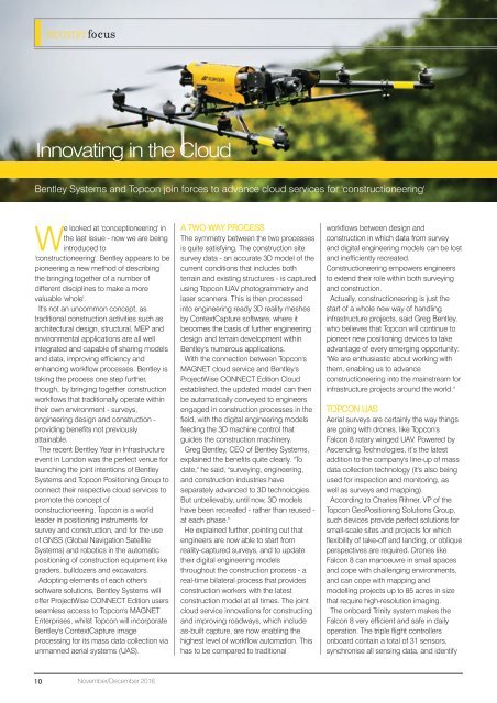
TOPCON UAS<br />
Aerial surveys are certainly the way things<br />
are going with drones, like Topcon's<br />
Falcon 8 rotary winged UAV. Powered by<br />
Ascending Technologies, it’s the latest<br />
addition to the company's line-up of mass<br />
data collection technology (it's also being<br />
used for inspection and monitoring, as<br />
well as surveys and mapping).<br />
According to Charles Rihner, VP of the<br />
Topcon GeoPositioning Solutions Group,<br />
such devices provide perfect solutions for<br />
small-scale sites and projects for which<br />
flexibility of take-off and landing, or oblique<br />
perspectives are required. Drones like<br />
Falcon 8 can manoeuvre in small spaces<br />
and cope with challenging environments,<br />
and can cope with mapping and<br />
modelling projects up to 85 acres in size<br />
that require high-resolution imaging.<br />
The onboard Trinity system makes the<br />
Falcon 8 very efficient and safe in daily<br />
operation. The triple flight controllers<br />
onboard contain a total of 31 sensors,<br />
synchronise all sensing data, and identify<br />
10<br />
November/December 2016