Scythian Culture - Preservation of The Frozen Tombs of The Altai Mountains (UNESCO)

Create successful ePaper yourself
Turn your PDF publications into a flip-book with our unique Google optimized e-Paper software.
PRESERVATION OF THE FROZEN TOMBS OF THE ALTAI MOUNTAINS<br />
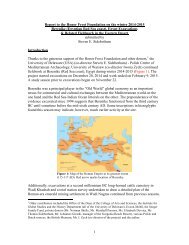
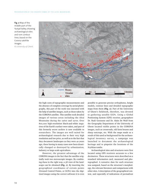
Fig. 2 Map <strong>of</strong> the<br />
middle part <strong>of</strong> the<br />
Yustyd Valley, showing<br />
archaeological sites<br />
and 10m contour<br />
lines, based on the<br />
Corona satellite<br />
images.<br />
© University <strong>of</strong> Ghent.<br />
the high costs <strong>of</strong> topographic measurements and<br />
the absence <strong>of</strong> complete coverage by aerial photographs,<br />
this part <strong>of</strong> the work was executed with<br />
the help <strong>of</strong> satellite images, such as those taken by<br />
the CORONA satellite. This satellite took detailed<br />
images <strong>of</strong> various areas including the <strong>Altai</strong><br />
<strong>Mountains</strong> during the 1960s and 1970s. Over<br />
800,000 high-resolution black-and-white negatives<br />
<strong>of</strong> the Earth’s surface were taken, and part <strong>of</strong><br />
this formerly secret archive is now available to<br />
researchers. <strong>The</strong> images are well suited for<br />
archaeological research due to their very high<br />
resolution and low price, as well as to the fact that<br />
they document landscapes as they were 40 years<br />
ago, these having in many cases now been drastically<br />
changed or destroyed by urbanization,<br />
industry or large-scale agriculture.<br />
However, the greatest advantage <strong>of</strong> the<br />
CORONA images is the fact that the satellite originally<br />
took two stereoscopic images. By combining<br />
these in the right way, a 3D view <strong>of</strong> the landscape<br />
can be obtained (Fig. 1). By inserting the<br />
geographical coordinates <strong>of</strong> certain points<br />
(Ground Control Points, or GCPs) into the digitized<br />
images using the correct s<strong>of</strong>tware it is even<br />
possible to generate precise orthophotos, height<br />
models, contour lines and detailed topographic<br />
maps from them (Fig. 2). Part <strong>of</strong> the University<br />
<strong>of</strong> Ghent’s fieldwork, therefore, was devoted<br />
to gathering useable GCPs. Using a Global<br />
Positioning System (GPS) receiver, geographers<br />
Dr. Rudi Goossens and Dr. Alain De Wulf from<br />
the Geography Department <strong>of</strong> the University <strong>of</strong><br />
Ghent located visible points in the CORONA<br />
images, such as crossroads, old farm houses and<br />
sharp outcrops, etc. With the maps made as a<br />
result <strong>of</strong> this used as background for the archaeological<br />
inventory survey, a campaign was<br />
launched to document the archaeological<br />
heritage and to pinpoint the locations <strong>of</strong> the<br />
<strong>Scythian</strong> tombs.<br />
Archaeological sites and structures were first<br />
located using GPS receivers accurate to a few<br />
decimetres. <strong>The</strong>se structures were described on a<br />
standard information card, measured and photographed.<br />
A tentative date for each structure<br />
was assigned, based on the structure’s morphology,<br />
the relevant literature and comparisons with<br />
other sites. A description <strong>of</strong> the geographical context,<br />
and especially <strong>of</strong> indications <strong>of</strong> permafrost<br />
56