JCS_MasterDocument_FIN_27.03.18

Create successful ePaper yourself
Turn your PDF publications into a flip-book with our unique Google optimized e-Paper software.
Policy A1 - Innsworth & Twigworth<br />
The Strategic Allocation identified at Innsworth & Twigworth (as shown on Policies map Plan A1)<br />
will be expected to deliver:<br />
i. Approximately 2,295 new homes;<br />
ii. Approximately 9 hectares of employment generating land;<br />
iii. A local centre including the provision of an appropriate scale of retail, healthcare and<br />
community facilities to meet the needs of the new community;<br />
iv. New primary and secondary education schools and facilities;<br />
v. A green infrastructure network of approximately 100 hectares, corresponding with flood<br />
zones 2 and 3;<br />
vi. Protection to key biodiversity assets, including a new nature reserve with the green<br />
infrastructure area to support the restoration of the SSSI and improve the ecology of the<br />
area to support restoration of the SSSI, improve the ecology of the area and contribute to<br />
water quality enhancements;<br />
vii. Adequate flood risk management across the site and ensure that all more vulnerable<br />
development is located wholly within flood zone 1. This includes measures to reduce flood<br />
risk downstream through increasing storage capacity;<br />
viii. Flood risk management will be a critical part of master planning the site in linking the<br />
Innsworth and Twigworth areas, avoiding overland flow routes and addressing surface<br />
water flooding. Detailed flood risk assessments must utilise the latest flood risk modelling<br />
information for the whole site and any other areas impacted by the development in terms of<br />
flood risk;<br />
ix. A layout and form of development that respects the landscape character as well as the<br />
character, significance and setting of heritage assets and the historic landscape.<br />
x. A layout and form that integrates, where appropriate, important hedgerows within the<br />
development;<br />
xi. A layout and form that reduces the impact of electricity pylons and high voltage lines; with<br />
the siting of residential development being a particular consideration;<br />
xii. Primary vehicle accesses from A38, Innsworth Lane and explore the potential for a new<br />
main junction onto the A40 to the south of the site;<br />
xiii. The potential for a highway link through both the Innsworth and Twigworth sites linking the<br />
A38 and A40;<br />
xiv. Measures necessary to mitigate the traffic impact of the site, including the use of travel<br />
plans to encourage the use of more sustainable transport modes;<br />
xv. High quality public transport facilities and connections within and adjacent to the site;<br />
xvi. Safe, easy and convenient pedestrian and cycle links within the site and to key centres,<br />
providing segregated links where practical.<br />
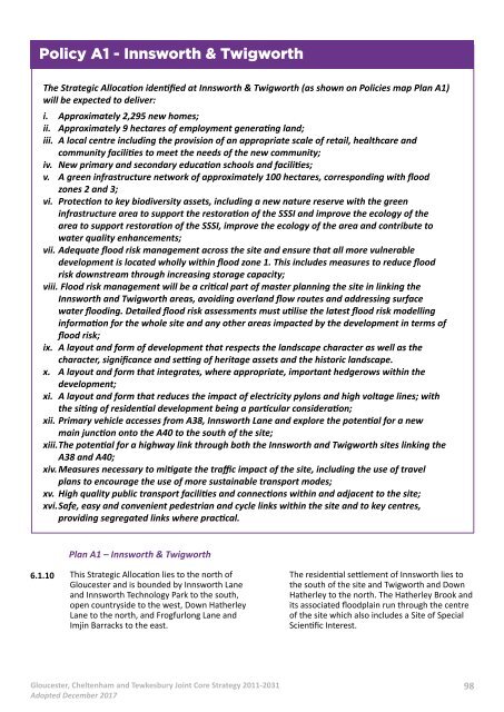
Plan A1 – Innsworth & Twigworth<br />
6.1.10<br />
This Strategic Allocation lies to the north of<br />
Gloucester and is bounded by Innsworth Lane<br />
and Innsworth Technology Park to the south,<br />
open countryside to the west, Down Hatherley<br />
Lane to the north, and Frogfurlong Lane and<br />
Imjin Barracks to the east.<br />
The residential settlement of Innsworth lies to<br />
the south of the site and Twigworth and Down<br />
Hatherley to the north. The Hatherley Brook and<br />
its associated floodplain run through the centre<br />
of the site which also includes a Site of Special<br />
Scientific Interest.<br />
Gloucester, Cheltenham and Tewkesbury Joint Core Strategy 2011-2031<br />
Adopted December 2017<br />
98