Currituck County Planning Board Agenda
Currituck County Planning Board Agenda
Currituck County Planning Board Agenda

Create successful ePaper yourself
Turn your PDF publications into a flip-book with our unique Google optimized e-Paper software.
PLANNING BOARD<br />
AGENDA<br />
September 11, 2012
Table of Contents<br />
<strong>Agenda</strong> 2<br />
PB 12-18 <strong>Currituck</strong> <strong>County</strong> Unified Development Ordinance<br />
Administrative Manual:<br />
12-18 Case Analysis 3<br />
PB 12-19 Barry Nelms:<br />
PB 12-19 Nelms (PB) 5<br />
PB 12-16 Farms and Timberland, Inc.:<br />
Case Analysis 8<br />
Concept Plan 13<br />
Application 14<br />
1
PLANNING BOARD<br />
JOE KOVACS<br />
Chairman<br />
JIM CLARK<br />
Vice-Chairman<br />
ROBERT BELL<br />
CLAY CARTWRIGHT<br />
<strong>Currituck</strong> <strong>County</strong><br />
<strong>Planning</strong> <strong>Board</strong> <strong>Agenda</strong><br />
Historic <strong>Currituck</strong> <strong>County</strong> Courthouse<br />
Tuesday, September 11, 2012, 7:00 PM<br />
Document last changed: 9/5/2012 9:06 AM<br />
PLANNING BOARD<br />
JOHN COOPER<br />
SUZANNE EVERHART<br />
FANNIE NEWBERN<br />
LYNNE WILSON<br />
JOHN WRIGHT<br />
Work Session<br />
6:00 p.m. Discussion of the new Unified Development Ordinance Text Amendments<br />
and current agenda items.<br />
7:00 p.m. Call to Order<br />
Pledge of Allegiance and Moment of Silence<br />
Item 1 Approval of <strong>Agenda</strong><br />
Item 2 Approval of Last Meeting Minutes<br />
PLEASE LIMIT PUBLIC COMMENTS TO THREE MINUTES<br />
OLD BUSINESS:<br />
Item 3 PB 12-18 <strong>Currituck</strong> <strong>County</strong> Unified Development Ordinance<br />
Administrative Manual: Request to approve the Administrative Manual<br />
for the new Unified Development Ordinance.<br />
NEW BUSINESS:<br />
Item 4 PB 12-19 Barry Nelms: Request to amend the new Unified Development<br />
Ordinance Chapter 5: Development Standards to allow off-premise<br />
directional signs for properties located adjacent to the <strong>Currituck</strong> Sound.<br />
Item 5 PB 12-16 Farms and Timberland, Inc.: Request for conditional zoning<br />
from Agricultural (A) to Conditional District-Single Family Mainland (CD-<br />
SFM) of 55.82 acres in Moyock on the south side of Baxter Lane, Tax<br />
Map 9, Parcels 25C, 25D, 25E, 25F, and 25G, Moyock Township.<br />
Adjourn<br />
2
MEMORANDUM<br />
To: <strong>Planning</strong> <strong>Board</strong><br />
From: <strong>Planning</strong> Staff<br />
Date: September 4, 2012<br />
Re: PB 12-18 Administrative Manual<br />
<strong>Currituck</strong> <strong>County</strong><br />
Department of <strong>Planning</strong><br />
153 Courthouse Road, Suite 110<br />
<strong>Currituck</strong>, North Carolina 27929<br />
252-232-3055<br />
FAX 252-232-3026<br />
The purpose of the administrative manual is to assist in the administration of the new Unified<br />
Development Ordinance (UDO). It is similar to the development review process manual of the<br />
current UDO. The administrative manual’s primary goal is to explain the review procedures of<br />
development applications established in the UDO. The manual contains, among other things:<br />
application forms, staff review checklist, planting details, and submittal and fee schedules. The<br />
manual consolidates information in the development review process, and helps applicants<br />
understand the procedures and requirements. The intent of the manual is more specifically to:<br />
A. Establish a process that is clear and understandable to all interested parties, applicants<br />
and staff;<br />
B. Clarify the standards and procedures for submitting complete and relevant information<br />
for development applications;<br />
C. Provide information and tools to assist applicants during the review process;<br />
D. Provide official interpretations of the UDO; and<br />
E. Establish planting standards that promote health and survival of landscaping installed in<br />
the county.<br />
The administrative manual is divided into three parts:<br />
1. Introduction<br />
The introduction provides background on the manual and its purpose, and recognizes it as<br />
part of the UDO.<br />
2. Procedures and Applications<br />
Contains detailed review processes, applications, and design and submittal checklists for<br />
all development applications established in the UDO.<br />
3. Appendices<br />
Contain standards that are applicable to all development applications, specifically, flood<br />
damage prevention, planting standards, and official interpretations. Also included are<br />
items that may assist applicants in the development review process including links to useful<br />
3
tools (UDO, Land Use Plan, online mapping) and staff review checklist. Finally, the<br />
appendices establish submittal and fee schedules for development applications.<br />
The administrative manual will be available on the county’s website for review. The direct link will<br />
be emailed to you once it is posted. Should you have any questions on the manual, please<br />
contact Brad Schuler, Planner I, at 232-6033 or Brad.Schuler@<strong>Currituck</strong><strong>County</strong>NC.gov.<br />
4<br />
PB 12-18<br />
Administrative Manual<br />
Page 2 of 2
To: <strong>Planning</strong> <strong>Board</strong><br />
From: <strong>Planning</strong> Staff<br />
Date: September 4, 2012<br />
Subject: PB 12-19 Off-Premise Directional Signage Text Amendment<br />
<strong>Currituck</strong> <strong>County</strong><br />
<strong>Planning</strong> and Community Development Department<br />
<strong>Planning</strong> and Zoning Division<br />
153 Courthouse Road, Suite 110<br />
<strong>Currituck</strong>, North Carolina 27929<br />
252-232-3055 FAX 252-232-3026<br />
The enclosed text amendment, submitted by Barry Nelms of Barry’s on Walnut Island Restaurant<br />
and Lodge, proposes to allow off-premise directional signage for businesses located adjacent to<br />
the <strong>Currituck</strong> Sound. This request is being reviewed as an amendment to the new Unified<br />
Development Ordinance (UDO).<br />
The UDO was recently amended to allow off-premise directional signage for businesses located<br />
adjacent to the Atlantic Intracoastal Waterway. This request would allow off-premise directional<br />
signage for businesses along the <strong>Currituck</strong> Sound under the same standards and procedures.<br />
While staff is sympathetic to the difficult economic times that exist for businesses, increasing the<br />
frequency of off-premise directional signage is not consistent with the policy objectives of the<br />
2006 Land Use Plan (Polices CA1, CA4, CA5). Policy CA5 states: “...that an attractive, less<br />
commercialized landscape, particularly along heavily traveled land and water routes, is essential<br />
to the tourist-based economy of the area. The placement of additional billboards and off-site<br />
advertising signs shall not be permitted in <strong>Currituck</strong> <strong>County</strong>.”<br />
Due to the policy direction included in the Land Use Plan, staff cannot support this text amendment<br />
request as it would only strengthen the precedent to allow off-premise signage in the county.<br />
5<br />
PB 12-19 Nelms (Off-Premise Sign)<br />
Page 1 of 3
<strong>Currituck</strong> <strong>County</strong><br />
PB 12-19<br />
UDO AMENDMENT REQUEST<br />
Amendment to the Unified Development Ordinance Chapter 5: Development Standards to allow<br />
off-premise directional signs for properties located adjacent to the <strong>Currituck</strong> Sound.<br />
BE IT ORDAINED by the <strong>Board</strong> of Commissioners of the <strong>County</strong> of <strong>Currituck</strong>, North Carolina that<br />
the Unified Development Ordinance of the <strong>County</strong> of <strong>Currituck</strong> be amended as follows:<br />
Item 1: That Table 5.12.4 Signs Exempted from Sign Permit Requirements is amended by adding<br />
the following underlined language and deleting the following strikethrough language:<br />
5.12.4. Signs Exempted from Sign Permit Requirements<br />
The signs in Table 5.12.4, Signs Exempted from Sign Permits, are exempt from the<br />
requirements to obtain sign permit approval, but are subject to the standards in<br />
Section 5.12.7, Maintenance Standards, and the standards in this sub-section.<br />
TABLE 5.12.4: SIGNS EXEMPTED FROM SIGN PERMITS<br />
SIGN TYPE EXAMPLE APPLICABLE STANDARDS<br />
Directional Sign, Off-<br />
Premise<br />
Up to one off-premise directional<br />
sign authorized by the <strong>Board</strong> of<br />
Commissioners may be placed on<br />
property under the same<br />
ownership as a business site<br />
located adjacent to the Atlantic<br />
Intracoastal Waterway and<br />
<strong>Currituck</strong> Sound.<br />
MAXIMUM<br />
SIGN AREA<br />
(SQ. FT)<br />
MAXIMUM<br />
HEIGHT<br />
(FEET)<br />
100 12<br />
Item 3: The provisions of this Ordinance are severable and if any of its provisions or any<br />
sentence, clause, or paragraph or the application thereof to any person or circumstance shall be<br />
held unconstitutional or violative of the Laws of the State of North Carolina by any court of<br />
competent jurisdiction, the decision of such court shall not affect or impair any of the remaining<br />
provisions which can be given effect without the invalid provision or application.<br />
6<br />
PB 12-19 Nelms (Off-Premise Sign)<br />
Page 2 of 3
Item 4: This ordinance amendment shall be in effect from and after the day of<br />
, 2012.<br />
<strong>Board</strong> of Commissioners’ Chairman<br />
Attest:<br />
Gwen H. Keene<br />
Clerk to the <strong>Board</strong><br />
DATE ADOPTED:<br />
MOTION TO ADOPT BY COMMISSIONER:<br />
SECONDED BY COMMISSIONER:<br />
VOTE: AYES NAYS<br />
PLANNING BOARD DATE:<br />
PLANNING BOARD RECOMMENDATION:<br />
VOTE: AYES NAYS<br />
ADVERTISEMENT DATE OF PUBLIC HEARING:<br />
BOARD OF COMMISSIONERS PUBLIC HEARING:<br />
BOARD OF COMMISSIONERS ACTION:<br />
POSTED IN UNIFIED DEVELOPMENT ORDINANCE:<br />
AMENDMENT NUMBER:<br />
7<br />
PB 12-19 Nelms (Off-Premise Sign)<br />
Page 3 of 3
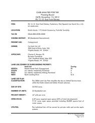
CASE ANALYSIS FOR THE<br />
Farms and Timberland, Inc.<br />
DATE: September 11, 2012<br />
PB 12-16 Farms & Timberland, Inc.<br />
ITEM: PB 12-16 Farms & Timberland, Inc. request for conditional zoning from<br />
Agricultural (A) to Conditional District-Single Family Mainland (CD-SFM) of<br />
55.82 acres in Moyock on the south side of Baxter Lane.<br />
LOCATION: Moyock: Baxter Lane, Moyock Township.<br />
TAX ID: 0009-000-025C-0000<br />
0009-000-025D-0000<br />
0009-000-025E-0000<br />
0009-000-025F-0000<br />
0009-000-025G-0000<br />
OWNER: Farms & Timberland, Inc.<br />
2225 Spinnaker Circle<br />
Virginia Beach, VA 23451<br />
APPLICANT: Eddie Hyman<br />
Hyman & Robey<br />
PO Box 339<br />
Camden, NC 27921<br />
LAND USE/ZONING OF SURROUNDING PROPERTY:<br />
Land Use Current Zoning New Zoning<br />
NORTH: Low Density Residential/Farmland A AG<br />
SOUTH Woodland/Low Density Residential/open LM/R LI/SFM<br />
space<br />
EAST: Low Density Residential/Farmland R/A SFM/AG<br />
WEST: Farmland A AG<br />
LAND USE PLAN<br />
CLASSIFICATION: The 2006 Land Use Plan classifies the site as Rural within the Moyock<br />
subarea.<br />
Areas designated as Rural are intended to provide for agriculture,<br />
forestry, and other allied uses traditionally associated with a rural<br />
area. With respect to residential development, Rural areas allow for a<br />
maximum density of 1 unit per 3 acres and would be served by on site<br />
well and septic.<br />
The policy emphasis of the Land Use Plan is for the Moyock subarea to<br />
properly manage the increased urban level of growth that this area is<br />
sure to experience. All four land use classifications are included in the<br />
Moyock subarea. The existing environmentally sensitive areas that<br />
cannot support higher density and do not have access to services are<br />
classified as either Conservation or Rural areas. Residential<br />
8<br />
PB 12-16 Farms & Timberland, Inc.<br />
Conditional Zoning<br />
Page 1 of 5
CURRENT ZONING: Agricultural (A)<br />
NEW ZONING: Agricultural (AG)<br />
development densities should be limited to 1-2 units per acre where<br />
onsite wastewater is proposed and other county services are limited. In<br />
areas where central sewer is proposed or existing, additional services<br />
are available and the character of the surround areas supports it,<br />
higher densities ranging from 3-4 units per acre could be considered<br />
through the use of overlay zones.<br />
The following Land Use Plan policy statement supports the request:<br />
POLICY HN3: <strong>Currituck</strong> <strong>County</strong> shall especially encourage two forms of<br />
residential development, each with the objective of avoiding traditional<br />
suburban sprawl:<br />
1. OPEN SPACE DEVELOPMENTS that cluster homes on less land,<br />
preserving permanently dedicated open space and often employ<br />
on-site or community sewage treatment. These types of<br />
developments are likely to occur primarily in the Conservation,<br />
Rural, and to a certain extend the Limited Service areas identified<br />
on the Future Land Use Plan Map.<br />
PROPOSED ZONING: Conditional District – Single Family Mainland (CD-SFM)<br />
CURRENT USE: Woodland<br />
SIZE OF SITE: 55.82 Acres<br />
ZONING HISTORY: The 1974 Official Zoning Map zoned the property RA-20.<br />
The 1989 Official Zoning Map zoned the property A.<br />
UTILITIES: An existing four inch water line along Baxter Road serves this property.<br />
The applicant is proposing a six inch waterline extension. Individual onsite<br />
septic systems are proposed for the individual lots.<br />
TRANSPORTATION: The property is accessed by Baxter Lane, a paved state maintained<br />
road.<br />
FLOOD ZONE: The property is located in a Shaded X flood zone (500-year<br />
floodplain) and AE (BFE 5.4’) flood zone.<br />
WETLANDS: The US Army Corps of Engineers identified no jurisdictional 404<br />
wetlands or waters on the property (January 15, 2010).<br />
SOILS: The <strong>Currituck</strong> <strong>County</strong> Soils Map indicates the property contains Roanoke<br />
and Augusta soils. The Roanoke soils (approximately 52.4 acres) are not<br />
suitable for on-site septic, and the Augusta soils are considered marginal.<br />
PROPOSED DENSITY: 0.64 units per acre based on the development site.<br />
9<br />
PB 12-16 Farms & Timberland, Inc.<br />
Conditional Zoning<br />
Page 2 of 5
PROPOSED ZONING CONDITIONS:<br />
1. The proposed use is a 36-lot single family subdivision having a minimum size of<br />
40,000 square feet and an overall density of 0.64 dwelling units/acre.<br />
2. Site built single family homes.<br />
3. The extension of a 6” water line and arrangements to ensure improvements of the<br />
road to the county property.<br />
a. OPTION 1: Bring a 6” water line from Moyock Landing Dr. north across the<br />
property owned by <strong>Currituck</strong> <strong>County</strong> through this tract to make a loop connection<br />
with the 4” water line at Baxter Lane.<br />
b. OPTION 2: Extend the existing 6” water line from the railroad tracks on Baxter<br />
Lane to the site. This option will be a dead end line.<br />
COMMUNITY MEETING:<br />
A community meeting was held July 25, 2012 at 7:00 pm at the Moyock Library. The<br />
neighborhood concerns include the unknown maintenance responsibilities of interconnected<br />
roads, stormwater impacts, and potential reduced water pressure.<br />
TECHNICAL REVIEW COMMITTEE RECOMMENDATION:<br />
The rezoning request is from Agricultural (A), a district established in the current/old UDO, to<br />
Conditional District – Single Family Mainland (CD-SFM), a newly established district of the<br />
new UDO. Although the 2006 Land Use Plan classifies the property as Rural, the proposed<br />
request could be considered consistent with the policy emphasis for the Moyock subarea<br />
based on the following:<br />
1. The property is located adjacent to Full Service classification.<br />
2. The proposed development will provide street interconnection from Baxter Lane to the<br />
county property located in Shingle Landing development and the adjacent property<br />
located to the east (n/f Jarvis & Dunstan).<br />
3. Utility infrastructure (six inch water line) will be extended to the property and within<br />
the proposed development.<br />
4. The property does not contain environmentally sensitive areas (404 wetlands).<br />
Outstanding Staff Concerns/Considerations: The conditional zoning process provides an<br />
opportunity for an applicant to propose use limitations or development conditions that ensure<br />
development proposals are consistent with the policies set forth in adopted plans. The<br />
following staff concerns/considerations could be appropriately addressed through the<br />
conditional zoning process:<br />
1. The existing water line along Baxter Road (east of the railroad) is a four inch line and<br />
does not meet the minimum utility requirements. Upgrading the existing water line to a<br />
six inch line would improve the development potential for properties along Baxter<br />
Road, but the upgrade would not loop or interconnect.<br />
2. <strong>Currituck</strong> <strong>County</strong> has not authorized or approved a water line extension through open,<br />
undeveloped public property. The proposed extension would not be placed within a<br />
road right-of-way.<br />
3. The existing vegetation (percentage) within the open space should be retained to<br />
reduce the maintenance burden on the association.<br />
10<br />
PB 12-16 Farms & Timberland, Inc.<br />
Conditional Zoning<br />
Page 3 of 5
The TRC recommends approval of the request to rezone 55.82 acres from Agricultural (A) to<br />
Conditional District – Single Family Mainland (CD-SFM) provided the outstanding concerns and<br />
considerations can be addressed and agreed to by the applicant.<br />
.<br />
11<br />
PB 12-16 Farms & Timberland, Inc.<br />
Conditional Zoning<br />
Page 4 of 5
12<br />
PB 12-16 Farms & Timberland, Inc.<br />
Conditional Zoning<br />
Page 5 of 5
N<br />
VICINITY MAP<br />
N<br />
LEGEND<br />
EXISTING MOYOCK LANDING DRIVE - 50' R/W<br />
PROPOSED STREET - 50' R/W<br />
BAXTER LANE - SR 1229 (60' R/W)<br />
PROPOSED STREET 50' R/W<br />
13<br />
BAXTER LANE (VARIABLE WIDTH' R/W)<br />
SOLUTIONS FROM THE GROUND UP<br />
150 US Hwy 158 E.<br />
PO Box 339<br />
Camden, NC 27921<br />
(252) 338-2913<br />
(252) 338-5552 fax<br />
www.hymanrobey.com<br />
License C-0598<br />
CONDITIONAL<br />
REZONING<br />
EXHIBIT<br />
MOYOCK TOWNSHIP<br />
CURRITUCK COUNTY<br />
NORTH CAROLINA<br />
KEY PLAN:<br />
Project #:<br />
Drawing #:<br />
Drawn:<br />
Checked:<br />
Approved:<br />
Date:<br />
Sheet #:<br />
Scale:<br />
REVISIONS:<br />
NUM. DATE DESCRIPTION<br />
SHEET TITLE:<br />
FOR<br />
FARMS &<br />
TIMBERLAND, INC.<br />
BEING<br />
PARCEL THREE PLAT CAB.<br />
M, SLIDE 103 AND<br />
D.B. 1209, PG. 263<br />
EXHIBIT<br />
SHEET NUMBER:<br />
1<br />
120083<br />
120083 EXHIBIT<br />
JAM / TLF / NMR<br />
TLF<br />
ETH<br />
06/28/2012<br />
1 OF 1<br />
1" = 200'