PB 12-10 East Point Estates - Currituck County Government
PB 12-10 East Point Estates - Currituck County Government
PB 12-10 East Point Estates - Currituck County Government

You also want an ePaper? Increase the reach of your titles
YUMPU automatically turns print PDFs into web optimized ePapers that Google loves.
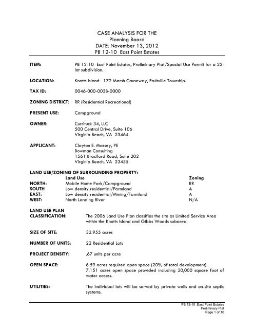
CASE ANALYSIS FOR THE<br />
Planning Board<br />
DATE: November 13, 20<strong>12</strong><br />
<strong>PB</strong> <strong>12</strong>-<strong>10</strong> <strong>East</strong> <strong>Point</strong> <strong>Estates</strong><br />
ITEM: <strong>PB</strong> <strong>12</strong>-<strong>10</strong> <strong>East</strong> <strong>Point</strong> <strong>Estates</strong>, Preliminary Plat/Special Use Permit for a 22lot<br />
subdivision.<br />
LOCATION: Knotts Island: 172 Marsh Causeway, Fruitville Township.<br />
TAX ID: 0046-000-003B-0000<br />
ZONING DISTRICT: RR (Residential Recreational)<br />
PRESENT USE: Campground<br />
OWNER: <strong>Currituck</strong> 34, LLC<br />
500 Central Drive, Suite <strong>10</strong>6<br />
Virginia Beach, VA 23464<br />
APPLICANT: Clayton E. Massey, PE<br />
Bowman Consulting<br />
1561 Bradford Road, Suite 202<br />
Virginia Beach, VA 23455<br />
LAND USE/ZONING OF SURROUNDING PROPERTY:<br />
Land Use Zoning<br />
NORTH: Mobile Home Park/Campground RR<br />
SOUTH Low density residential/Farmland A<br />
EAST: Low density residential/Mining/Farmland A<br />
WEST: North Landing River<br />
N/A<br />
LAND USE PLAN<br />
CLASSIFICATION: The 2006 Land Use Plan classifies the site as Limited Service Area<br />
within the Knotts Island and Gibbs Woods subarea.<br />
SIZE OF SITE: 32.955 acres<br />
NUMBER OF UNITS: 22 Residential Lots<br />
PROJECT DENSITY: .67 units per acre<br />
OPEN SPACE: 6.59 acres required open space (20% of total development).<br />
7.151 acres open space provided including 20,000 square foot of<br />
water access.<br />
UTILITIES: The individual lots will be served by private wells and on-site septic<br />
systems.<br />
<strong>PB</strong> <strong>12</strong>-<strong>10</strong> <strong>East</strong> <strong>Point</strong> <strong>Estates</strong><br />
Preliminary Plat<br />
Page 1 of <strong>10</strong>
I. NARRATIVE OF REQUEST:<br />
1. <strong>Currituck</strong> 34, LLC is requesting preliminary plat/special use permit approval of a 22 lot<br />
residential subdivision with an overall project density of .67 units per acre.<br />
2. The proposed development includes a 20,000 square foot water access. However, the<br />
area provided is linear in shape which may reduce the overall access potential. Access is<br />
provided to an existing boat ramp.<br />
3. The sketch plan was approved October <strong>12</strong>, 20<strong>12</strong>.<br />
II. QUESTION(S) BEFORE THE BOARD:<br />
Special Use Permit Criteria and Staff Findings:<br />
Special use permits (SUP) are intended to allow the Board of Commissioners flexibility in the<br />
administration of the UDO. Through the SUP procedure, property uses which would otherwise<br />
be considered undesirable in certain districts can be developed subject to conditions of<br />
approval to minimize any negative effects they might have on surrounding properties.<br />
In order to approve a SUP, certain criteria must be satisfied. The criteria and suggested<br />
findings of fact are outlined as follows:<br />
1. Completeness of application.<br />
Suggested Findings:<br />
a. The application is complete.<br />
2. The proposed use is among those listed in the Table of Permissible Uses as a special use<br />
indicated with an “S”.<br />
Suggested Findings:<br />
a. Chapter <strong>10</strong> of the UDO allows a major subdivision as a permissible use with a special<br />
use permit.<br />
3. The conditions proposed meet or exceed the minimum requirements of this ordinance.<br />
Suggested Findings:<br />
a. As presented, the subdivision meets or exceeds the minimum requirements of the<br />
ordinance.<br />
4. The special use will not endanger the public health or safety:<br />
Suggested Findings:<br />
a. The subdivisions should have little to no impact on public health or safety.<br />
5. The special use will not injure the value of adjoining or abutting property and will be in<br />
harmony with the area in which it is located<br />
Suggested Findings:<br />
a. The UDO indicates that a subdivision is allowed in the RR zoning district with a special<br />
use permit.<br />
b. The proposed residential subdivision shall harmonize well with the surrounding<br />
community.<br />
<strong>PB</strong> <strong>12</strong>-<strong>10</strong> <strong>East</strong> <strong>Point</strong> <strong>Estates</strong><br />
Preliminary Plat<br />
Page 2 of <strong>10</strong>
6. The special use will be in conformity with the Land Use Plan or other officially adopted<br />
plan.<br />
Suggested Findings:<br />
The 2006 Land Use Plan classifies this site as Limited Services within the Knotts Island and<br />
Gibbs Woods subarea. The Limited Services area is to provide for primarily residential<br />
development at low densities. Base density should be one unit per acre but could be<br />
increased to 1.5 units per acre through overlay zoning depending upon whether service<br />
facilities are in placed or planned on the surrounding community. The policy emphasis for<br />
the developable areas of Knotts Island is to remain as low to very low density residential<br />
areas; predominantly 1 unit per 3 acres. The proposed use is in keeping with the policies<br />
of the plan, some of which are:<br />
POLICY HN1: <strong>Currituck</strong> <strong>County</strong> shall encourage development to occur at densities<br />
appropriate for the location. LOCATION AND DENSITY FACTORS shall include whether the<br />
development is within an environmentally suitable area, the type and capacity of sewage<br />
treatment available to the site, the adequacy of transportation facilities providing access to<br />
the site, and the proximity of the site to existing and planned urban services. For example,<br />
projects falling within the Full Services areas of the Future Land Use Map would be<br />
permitted a higher density because of the availability of infrastructure as well as similarity<br />
to the existing development pattern. Such projects could be developed at a density of two<br />
(2) or more dwelling units per acre. Projects within areas designated as Limited Service<br />
would be permitted a density of one (1) to one and one half (1.5) units per acre depending<br />
upon the surrounding development pattern and availability of resources. Projects within<br />
areas designated as Rural or Conservation by the Future Land Use Plan would be permitted<br />
a much lower density of 1 dwelling unit per 3 acres because of the lack of infrastructure in<br />
the area, the existing low density development pattern, and presence of environmentally<br />
sensitive natural areas.<br />
POLICY KI1: The need for ACCESS TO PUBLIC TRUST WATERS in the Knotts Island area shall<br />
be met through periodic improvements to existing public facilities. The <strong>County</strong> also<br />
recognizes that private sector facilities may play a role in satisfying access needs to the<br />
water.<br />
7. The special use will not exceed the county's ability to provide adequate public facilities,<br />
including, but not limited to, schools, fire and rescue, law enforcement, and other county<br />
facilities. Applicable state standards and guidelines shall be followed for determining<br />
when public facilities are adequate. Such facilities must be in place or programmed to be<br />
in place within two years after the initial approval of the plan (sketch plan in the case of<br />
major subdivisions).<br />
Suggested Findings:<br />
a. The proposed 22 lot residential subdivision will not exceed the county’s ability to<br />
provide adequate public facilities.<br />
III. TECHNICAL REVIEW COMMITTEE RECOMMENDATION:<br />
Pursuant to the Unified Development Ordinance, the Technical Review Committee recommends<br />
approval subject to the following plan corrections:<br />
<strong>PB</strong> <strong>12</strong>-<strong>10</strong> <strong>East</strong> <strong>Point</strong> <strong>Estates</strong><br />
Preliminary Plat<br />
Page 3 of <strong>10</strong>
Planning:<br />
1. A signed copy of the US Army Corps of Engineer’s wetland delineation and jurisdictional<br />
determination shall be provided that is consistent with the preliminary determination.<br />
2. Three full size copies of the revised open space calculations must be provided.<br />
3. The road names must be provided and approved.<br />
4. A hardsurfaced, ADA accessible trail system may be provided in the 22 lot residential<br />
subdivision in lieu of sidewalks on both sides of the proposed streets.<br />
NC State Archaeology:<br />
5. A Phase I Cultural Resources Survey was completed by Circa- Cultural Resource<br />
Management, LLC in June, 20<strong>12</strong>. Due to the sites high probability for potentially<br />
significant archaeological resources, the OSA is recommending that the project approvals<br />
include the following conditions:<br />
1. Prior to initiation of any ground disturbing activities within the project area, the<br />
permittee shall arrange for an archaeological survey and assessment of the entire<br />
project area. The purpose of the survey will be to locate archaeological sites within<br />
the project area and to determine if they are significant in terms of the National<br />
Register of Historic Places.<br />
2. If a significant site is located within the project area the permittee shall determine<br />
whether the site will be adversely affected by the project activities; and, if so,<br />
develop and implement an appropriate mitigation plan. Two copies of all resulting<br />
archaeological reports, as well as one copy of the North Carolina site forms, should be<br />
forwarded to the Office of State Archaeology for review and comment as soon as<br />
they are available and in advance of any construction or ground disturbance activities.<br />
A list of archaeological consultants who have conducted or expressed an interest in<br />
contract work in North Carolina is available at www.arch.dcr.state.nc.us/consults.htm.<br />
The archaeologists listed, or any other experienced archaeologist, may be contacted<br />
to conduct the recommended survey. All activities associated with the archaeological<br />
investigations shall be coordinated with the Office of State Archaeology prior to<br />
beginning any archaeological fieldwork.<br />
<strong>PB</strong> <strong>12</strong>-<strong>10</strong> <strong>East</strong> <strong>Point</strong> <strong>Estates</strong><br />
Preliminary Plat<br />
Page 4 of <strong>10</strong>
<strong>PB</strong> <strong>12</strong>-<strong>10</strong> <strong>East</strong> <strong>Point</strong> <strong>Estates</strong><br />
Preliminary Plat<br />
Page 5 of <strong>10</strong>
<strong>PB</strong> <strong>12</strong>-<strong>10</strong> <strong>East</strong> <strong>Point</strong> <strong>Estates</strong><br />
Preliminary Plat<br />
Page 6 of <strong>10</strong>
MEMORANDUM<br />
To: Clay Massey, Bowman Consulting<br />
Mike Sifen, <strong>Currituck</strong> 34, LLC<br />
From: Planning Staff<br />
Date: August 15, 20<strong>12</strong><br />
Re: <strong>East</strong> <strong>Point</strong> <strong>Estates</strong>, Preliminary Plat<br />
The following comments have been received for the August 15, 20<strong>12</strong> TRC meeting. In order to be<br />
scheduled for the September 11, 20<strong>12</strong> Planning Board meeting, please address all comments<br />
and resubmit a corrected plan by 3:00 p.m. on August 20, 20<strong>12</strong>. TRC comments are valid for six<br />
months from the date of the TRC meeting.<br />
Planning, Donna Voliva 252-232-6032<br />
Approved with comments<br />
1. The plans submitted and titled Sketch Plans appear to be preliminary construction plans<br />
and not a sketch plan and contain additional information. A sketch plan (other than<br />
preconstruction plans) should be submitted and approved by August 20, 20<strong>12</strong> in order to<br />
remain on the schedule outlined above.<br />
2. Please provide the completed Special Use Permit application (pages 5 and 6)<br />
3. The vicinity map must have a scale of 1”=2,000’ or larger.<br />
4. Please provide the smallest lot size on the preliminary plat. The information is provided<br />
on the plat titled sketch plan.<br />
5. Please provide the parcel ID number on the preliminary plat. The information is provided<br />
on the plat titled sketch plan.<br />
6. Please provide the total number of lots in the preliminary plat. The information is provided<br />
on the plat titled sketch plan.<br />
7. All interior lots (excluding cul-de-sac lots) shall have a minimum lot width of <strong>12</strong>5’<br />
measured at the front setback line.<br />
8. Will any portion of Pond 2 be filled?<br />
9. All double front lots shall have a 5 foot non ingress/egress easement on the most travelled<br />
roadway (include lots 11 and <strong>12</strong>).<br />
<strong>10</strong>. Please identify the actual location of any 404 Wetlands as defined by the US Army<br />
Corps of Engineers.<br />
11. Please provide suitable lot evaluations prepared by Albemarle Regional Health Services<br />
for all 22 lots.<br />
<strong>12</strong>. The proposed reserve utility open space appears to be located in a ditch. This area must<br />
be suitable in terms of size, location, soil type, topography, and other relevant factors to<br />
accommodate a treatment area if one becomes necessary due to septic tank failure or<br />
other reasons. Specifications must be provided to the satisfaction of the county engineer<br />
and Board of Commissioners. Please clarify if the reserve utility open space is included in<br />
the Open Space B calculations.<br />
<strong>PB</strong> <strong>12</strong>-<strong>10</strong> <strong>East</strong> <strong>Point</strong> <strong>Estates</strong><br />
Preliminary Plat<br />
Page 7 of <strong>10</strong>
13. The preliminary construction plans must include the location of all street identification<br />
signage and stop signs.<br />
14. The preliminary plat shall contain the Statement of Environmental Concern found in the<br />
Development Review Process Manual.<br />
15. The maps in the Phase I Cultural Resources Survey of <strong>East</strong> Pont <strong>Estates</strong> do not appear to<br />
reflect the actual location of the property.<br />
16. Please correct the water body name on all documents.<br />
17. Please correct the flood zone along the waterway to AE 6’.<br />
18. Please provide road names and the approval form for all proposed roads in the<br />
subdivision.<br />
19. Please provide the water access open space area calculation on the preliminary plat. The<br />
ordinance requires a minimum 20,000 square feet water access to public trust or estuarine<br />
waters.<br />
20. Please label the CAMA Area of Environmental Concern (75’ from the water’s edge).<br />
21. Please provide the surface material for the trail system.<br />
22. All improved areas of the trail system shall maintain a <strong>10</strong>’ setback from all property lines.<br />
23. The preconstruction plans (illustrated as sketch plan) should include the township<br />
information.<br />
24. Street trees (small deciduous) shall be spaced 30 feet on center for the length of street<br />
frontage.<br />
25. Please provide the basis for the 85’ and 90’ front setback for lots 5 and 6.<br />
<strong>Currituck</strong> Soil and Water, Mike Doxey<br />
Reviewed<br />
1. Building Pad elevations (BPE) and Finished Floor elevations (FFE) should be shown on each<br />
lot. The BPE should be at or above the <strong>10</strong> yr 24 hr storm and the FFE is 18" above the<br />
BPE. In this case, due to soil type, proximity to the sound and elevation, if the <strong>10</strong>yr/24hr<br />
storm is below existing ground level, there may be no need to add fill for the building<br />
pads. (the BPE will be the existing ground elevations)<br />
2. Due to the slope on the swales heading for the shoreline the state will probably require<br />
rock check dams at every foot of elevation drop. We would require a rock check dam at<br />
the outlet end of each swale to slow the velocity and dissipate the flow into the wooded<br />
area before entering the sound.<br />
<strong>Currituck</strong> <strong>County</strong> Engineer, Michelle Perry<br />
Reviewed<br />
1. Provide building pad and first floor elevations.<br />
2. Provide state permits.<br />
3. The <strong>10</strong>yr. post development runoff shall not exceed the <strong>10</strong>yr pre development runoff.<br />
4. The reserve septic field needs to be on suitable soils.<br />
These comments will not hold up approval of preliminary plat, but need to be addressed at<br />
pre-construction.<br />
<strong>Currituck</strong> <strong>County</strong> Utilities, Pat Irwin<br />
No comment<br />
<strong>Currituck</strong> <strong>County</strong> Emergency Management, James Mims 252-264-6641<br />
Denied/Resubmit<br />
<strong>PB</strong> <strong>12</strong>-<strong>10</strong> <strong>East</strong> <strong>Point</strong> <strong>Estates</strong><br />
Preliminary Plat<br />
Page 8 of <strong>10</strong>
1. The area at the pond for the fire apparatus must be 20 feet wide and should take the<br />
measurements located in appendix d of the fire code.<br />
2. Need to see the calculations used for the fire pond capacity. This should be in a sealed<br />
format. More detail is needed in regards to dimensions of the dry hydrant.<br />
3. It appears that one cul-de-sac is less than 96 feet in diameter.<br />
<strong>Currituck</strong> <strong>County</strong> Code Enforcement, Stacey Smith 252-232-6027<br />
No comment<br />
<strong>Currituck</strong> <strong>County</strong> Building Inspections, Spence Castello 252-232-6020<br />
Approved<br />
<strong>Currituck</strong> <strong>County</strong> Parks and Recreation, Jason Weeks 252-232-3007<br />
No comment<br />
NC Division of Coastal Management, Charlan Owens<br />
Reviewed<br />
1. Review of proposed land disturbance and development activities suggests that a CAMA<br />
Major Permit may be required. Please contact Ron Renaldi at 264-3901 to discuss the<br />
project.<br />
NC State Archaeology, Lawrence Abbot<br />
Reviewed<br />
1. The project area is located on a tract of land overlooking the North Landing River. Other<br />
archaeological sites are located in the general vicinity of the project area in a similar<br />
setting. The project tract is considered a high probability area for potentially significant<br />
archaeological resources. As a result, we recommend that the project approvals include<br />
the following conditions:<br />
a. Prior to initiation of any ground disturbing activities within the project area, the<br />
permittee shall arrange for an archaeological survey and assessment of the entire<br />
project area. The purpose of the survey will be to locate archaeological sites<br />
within the project area and to determine if they are significant in terms of the<br />
National Register of Historic Places.<br />
b. If a significant site is located within the project area the permittee shall determine<br />
whether the site will be adversely affected by the project activities; and, if so,<br />
develop and implement an appropriate mitigation plan. Two copies of all resulting<br />
archaeological reports, as well as one copy of the North Carolina site forms,<br />
should be forwarded to the Office of State Archaeology for review and comment<br />
as soon as they are available and in advance of any construction or ground<br />
disturbance activities.<br />
A list of archaeological consultants who have conducted or expressed an interest in<br />
contract work in North Carolina is available at www.arch.dcr.state.nc.us/consults.htm.<br />
The archaeologists listed, or any other experienced archaeologist, may be contacted<br />
to conduct the recommended survey. All activities associated with the archaeological<br />
investigations shall be coordinated with the Office of State Archaeology prior to<br />
beginning any archaeological fieldwork.<br />
Albemarle Regional Health Services, Joe Hobbs 252-232-6603<br />
<strong>PB</strong> <strong>12</strong>-<strong>10</strong> <strong>East</strong> <strong>Point</strong> <strong>Estates</strong><br />
Preliminary Plat<br />
Page 9 of <strong>10</strong>
Reviewed<br />
1. Please consult with Kevin Carver, RS at 252-232-6603 concerning septic system and<br />
private well approval for each lot that will make up this proposed subdivision.<br />
US Army Corps of Engineers, Kyle Barnes 9<strong>10</strong>-251-4584<br />
Reviewed<br />
1. Any impacts to jurisdictional waters or wetlands of the US require prior approval from the<br />
US Army Corps of Engineers.<br />
The following items are necessary for resubmittal:<br />
• 3 - full size copies of revised plans.<br />
• <strong>10</strong> - 11”x17” copies of revised plans.<br />
• 1- 8.5”x11” copy of all revised plans.<br />
• 1- PDF digital copy of all revised documents and plans.<br />
<strong>PB</strong> <strong>12</strong>-<strong>10</strong> <strong>East</strong> <strong>Point</strong> <strong>Estates</strong><br />
Preliminary Plat<br />
Page <strong>10</strong> of <strong>10</strong>