The Mountain Times - Volume 48, Number 47: Nov. 20-26, 2019
- No tags were found...

Create successful ePaper yourself
Turn your PDF publications into a flip-book with our unique Google optimized e-Paper software.
4 • LOCAL NEWS<br />
<strong>The</strong> <strong>Mountain</strong> <strong>Times</strong> • <strong>Nov</strong>. <strong>20</strong>-<strong>26</strong>, <strong>20</strong>19<br />
WARM, WATERPROOF,<br />
LIGHTWEIGHT WINTER BOOTS<br />
Woodstock Ave.<br />
RT 4 East, Rutland<br />
sensibleshoe.com<br />
Open 7 days<br />
(802) 773- 7515<br />
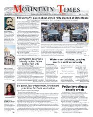
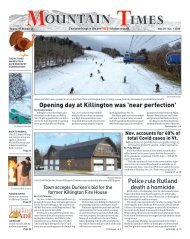
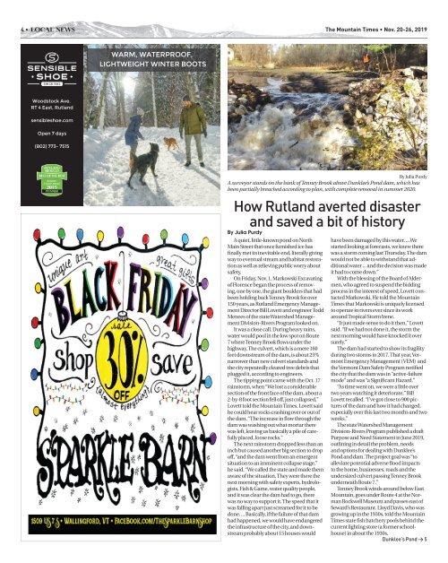
By Julia Purdy<br />
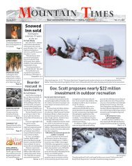
A surveyor stands on the bank of Tenney Brook above Dunklee’s Pond dam, which has<br />
been partially breached according to plan, with complete removal in summer <strong>20</strong><strong>20</strong>.<br />
Ho w Rutland averted disaster<br />
and saved a bit of history<br />
By Julia Purdy<br />
A quiet, little-known pond on North<br />
Main Street that once furnished ice has<br />
finally met its inevitable end, literally giving<br />
way to eventual stream and habitat restoration<br />
as well as relieving public worry about<br />
safety.<br />
On Friday, <strong>Nov</strong>. 1, Markowski Excavating<br />
of Florence began the process of removing,<br />
one by one, the giant boulders that had<br />
been holding back Tenney Brook for over<br />
150 years, as Rutland Emergency Management<br />
Director Bill Lovett and engineer Todd<br />
Menees of the state Watershed Management<br />
Division-Rivers Program looked on.<br />
It was a close call. During heavy rains,<br />
water would pool in the low spot on Route<br />
7 where Tenney Brook flows under the<br />
highway. <strong>The</strong> culvert, which is a mere 160<br />
feet downstream of the dam, is about 25%<br />
narrower than new culvert standards and<br />
the city repeatedly cleared tree debris that<br />
plugged it, according to engineers.<br />
<strong>The</strong> tipping point came with the Oct. 17<br />
rainstorm, when “We lost a considerable<br />
section of the front face of the dam, about a<br />
2-by-8 foot section fell off, just collapsed,”<br />
Lovett told the <strong>Mountain</strong> <strong>Times</strong>. Lovett said<br />
he could hear rocks crashing over or out of<br />
the dam. “<strong>The</strong> increase in flow through the<br />
dam was washing out what mortar there<br />
was left, leaving us basically a pile of carefully<br />
placed, loose rocks.”<br />
<strong>The</strong> next rainstorm dropped less than an<br />
inch but caused another big section to drop<br />
off, “and the dam went from an emergent<br />
situation to an imminent collapse stage,”<br />
he said. “We called the state and made them<br />
aware of the situation. <strong>The</strong>y were there the<br />
next morning with safety experts, hydrologists,<br />
Fish & Game, water quality people,<br />
and it was clear the dam had to go, there<br />
was no way to support it. <strong>The</strong> speed that it<br />
was falling apart just screamed for it to be<br />
done. ... Basically, if the failure of that dam<br />
had happened, we would have endangered<br />
the infrastructure of the city, and downstream<br />
probably about 15 houses would<br />
have been damaged by this water. ... We<br />
started looking at forecasts, we knew there<br />
was a storm coming last Thursday. <strong>The</strong> dam<br />
would not be able to withstand that additional<br />
water ... and the decision was made<br />
it had to come down.”<br />
With the blessing of the Board of Aldermen,<br />
who agreed to suspend the bidding<br />
process in the interest of speed, Lovett contacted<br />
Markowski. He told the <strong>Mountain</strong><br />
<strong>Times</strong> that Markowski is uniquely licensed<br />
to operate in rivers ever since its work<br />
around Tropical Storm Irene.<br />
“It just made sense to do it then,” Lovett<br />
said. “If we had not done it, the storm the<br />
next morning would have knocked it over<br />
surely.”<br />
<strong>The</strong> dam had started to show its fragility<br />
during two storms in <strong>20</strong>17. That year, Vermont<br />
Emergency Management (VEM) and<br />
the Vermont Dam Safety Program notified<br />
the city that the dam was in “active-failure<br />
mode” and was “a Significant Hazard.”<br />
“As time went on, we were a little over<br />
two years watching it deteriorate,” Bill<br />
Lovett recalled. “I’ve got close to 900 pictures<br />
of the dam and how it had changed,<br />
especially over this last two months and two<br />
weeks.”<br />
<strong>The</strong> state Watershed Management<br />
Division-Rivers Program published a draft<br />
Purpose and Need Statement in June <strong>20</strong>19,<br />
outlining in detail the problem, needs<br />
and options for dealing with Dunklee’s<br />
Pond and dam. <strong>The</strong> project goal was “to<br />
alleviate potential adverse flood impacts<br />
to the home, businesses, roads and the<br />
undersized culvert passing Tenney Brook<br />
underneath Route 7.”<br />
Tenney Brook winds around below East<br />
<strong>Mountain</strong>, goes under Route 4 at the Norman<br />
Rockwell Museum and passes east of<br />
Seward’s Restaurant. Lloyd Davis, who was<br />
growing up in the 1930s, told the <strong>Mountain</strong><br />
<strong>Times</strong> state fish hatchery pools behind the<br />
current lighting store (a former schoolhouse)<br />
in about the 1930s.<br />
Dunklee’s Pond > 5