Selwyn Times: January 08, 2020

You also want an ePaper? Increase the reach of your titles
YUMPU automatically turns print PDFs into web optimized ePapers that Google loves.
8 Wednesday <strong>January</strong> 8 <strong>2020</strong><br />
Latest Canterbury news at starnews.co.nz<br />
SELWYN TIMES<br />
News<br />
Brookside – the district’s best<br />
THE SMALL picturesque<br />
hamlet of Brookside is a historic<br />
gem in the story of colonial<br />
settlement in the <strong>Selwyn</strong><br />
District, even though few people<br />
other than Ellesmere locals know<br />
where it is or that it even exists.<br />
Now no more than a small<br />
number of old buildings dating<br />
back to the 1860s, along with a<br />
few farms and lifestyle blocks,<br />
nestled among woodlots of<br />
beautiful mature specimen trees,<br />
Brookside is an important living<br />
link to the district’s past and was<br />
once a thriving community.<br />
Located at the intersections of<br />
Brookside-Burnham Rd, Brookside-Irwell<br />
Rd, and Boundary<br />
Creek Rd, the best approach to<br />
the settlement is from <strong>Selwyn</strong><br />
Lake Rd.<br />
Originally known as South<br />
<strong>Selwyn</strong>, this name caused some<br />
confusion with the nearby village<br />
of <strong>Selwyn</strong> – located on the<br />
south side of the current <strong>Selwyn</strong><br />
bridge on State Highway 1. In<br />
1870 the name of the settlement<br />
was changed to Brookside in<br />
honour of Thomas Brooks who<br />
had gifted land for the establishment<br />
of the school and the<br />
Methodist Church.<br />
Brookside is now dominated<br />
by fertile farmland, but<br />
in its natural state it was heavy<br />
swampland covered in flax and<br />
raupo. There was also some lighter<br />
drier land covered in tussock<br />
in parts of the area, especially on<br />
the north side of the Irwell Creek<br />
that runs through the hamlet<br />
towards Irwell and on to Lake<br />
Ellesmere.<br />
It is unknown whether there<br />
was any permanent Maori settlement<br />
in the area, but there<br />
was evidence found of middens<br />
and stone implement during the<br />
colonial era that indicated some<br />
form of earlier occupation.<br />
The first freehold land at<br />
Brookside was made available in<br />
1860, which led to a number of<br />
pioneering families taking the<br />
opportunity to establish their<br />
own small farms.<br />
In 1861 Isaac Mawson was the<br />
Historian and district council staff member Wayne<br />
Stack continues his monthly look at <strong>Selwyn</strong>’s past.<br />
Anyone with suggestions for future features can<br />
phone Wayne on 021 119 9107. This month’s feature<br />
is about the hamlet of Brookside.<br />
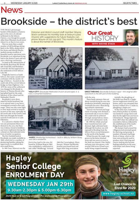
‘HOLY CITY’: Brookside Methodist Church around 1900, it is<br />
now a converted residence. <br />
HARDY: Middlerigg homestead – built in 1884 by William Boag<br />
and still in existence.<br />
first to buy land in the area, followed<br />
by William Boag in 1862<br />
who established a substantial estate<br />
called ‘Middlerigg’. Around<br />
1864 the Cunningham, Moor,<br />
Stewart, Watson and Brooks<br />
families purchased land and<br />
began their long association<br />
Our Great<br />
history<br />
WITH WAYNE STACK<br />
ONCE THRIVING: Brookside School in 1937 – the original 1867<br />
classroom is the left part of the building.<br />
with the area.<br />
These hardy pioneers then set<br />
about transforming the area into<br />
productive farmland, ensuring it<br />
eventually became a flourishing<br />
agricultural community.<br />
Tussock was burned and large<br />
tracks of swamp were drained; a<br />
mammoth task in an era when<br />
this could only be achieved<br />
through manual labour, horsepower<br />
and rudimentary tools.<br />
By 1900 the whole area had<br />
been transformed into welldrained,<br />
high cultivated land;<br />
although the location was still<br />
exposed to flooding from the<br />
<strong>Selwyn</strong> River several kilometers<br />
to the north of the hamlet.<br />
Wheat became the staple crop<br />
grown in the better drained<br />
areas and was sown as soon as<br />
the land was cleared. Oats, barley<br />
and peas were also grown, with<br />
around 3500 acres of land eventually<br />
being cropped annually.<br />
Initially, the ploughing of<br />
the fields was done by a singlefurrow<br />
implement towed by two<br />
horses, and it was estimated that<br />
farmers walked 10 to 12 miles in<br />
ploughing a single acre.<br />
In the early years, transportation<br />
of farm produce to markets<br />
was limited to using a horse and<br />
dray for the eight-hour journey to<br />
Christchurch. Things improved<br />
from 1869 when the railhead was<br />
extended to <strong>Selwyn</strong>, followed by<br />
the establishment of the Southbridge<br />
branch line in 1875.<br />
The damper land around the<br />
village proved extremely good<br />
for dairying and grazing. A<br />
number of farmers had large<br />
flocks of sheep, which at the<br />
time were primarily used to<br />
produce wool. Dairying and<br />
cheese-making also became<br />
leading industries in the area,<br />
with butter and cheese being<br />
exported.<br />
Last Chance to<br />
Enrol for <strong>2020</strong>