Identification of dry and rainy periods using telecommunication ...
Identification of dry and rainy periods using telecommunication ...
Identification of dry and rainy periods using telecommunication ...

Create successful ePaper yourself
Turn your PDF publications into a flip-book with our unique Google optimized e-Paper software.
12 nd International Conference on Urban Drainage, Porto Alegre/Brazil, 10-15 September 2011<br />
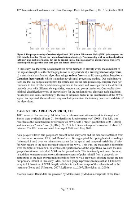
Figure 1 The pre-processing <strong>of</strong> received signal level (RSL) from Microwave Links (MWL) decomposes the<br />
RSL into the baseline (B) <strong>and</strong> the rain-induced attenuation (Atot). Pre-processing with an online-algorithm<br />
(left) only uses past information, but can be applied in real-time data analysis <strong>and</strong> operation. The corresponding<br />
<strong>of</strong>fline algorithm uses both past <strong>and</strong> future observations.<br />
In this study, we therefore developed three novel methods to classify every measurement <strong>of</strong><br />
the signal strength as either belonging to wet or <strong>dry</strong> <strong>periods</strong>: i) a moving window algorithm,<br />
ii) a statistical classification algorithm <strong>using</strong> r<strong>and</strong>om forests <strong>and</strong> iii) an algorithm based on a<br />
Gaussian factor graph, which is a rather novel signal-processing method. Our main innovations<br />
are that we suggest algorithms for <strong>of</strong>fline <strong>and</strong> online data processing, compare their performance<br />
to that <strong>of</strong> others published algorithms in literature <strong>and</strong> investigate how the different<br />
methods cope with different data qualities, temporal <strong>and</strong> power resolution. Our results show<br />
minimal classification errors <strong>of</strong> precipitation for the r<strong>and</strong>om forest, although each algorithm<br />
has its pros <strong>and</strong> cons. Interestingly, the major influence factor is the quantization <strong>of</strong> the MWL<br />
signal. As expected, the results are very much dependent on the training procedure <strong>and</strong> data <strong>of</strong><br />
the algorithms.<br />
CASE STUDY AREA IN ZURICH, CH<br />
MWL network: For our study, 14 links from a <strong>telecommunication</strong> network in the region <strong>of</strong><br />
Zurich were available (Figure 2). For details see Rieckermann et al. (2009). The RSL was<br />
recorded as the instantaneous power from ten MWL with a “fine” quantization <strong>of</strong> 0.1 [dBm]<br />
<strong>and</strong> four with a “coarse” one (1 [dBm]: No. 2, 3, 6, 11) <strong>and</strong> a temporal resolution <strong>of</strong> about 2.5<br />
minutes. The RSL were recorded from April 2009 until May 2010.<br />
Rain gauges: Eleven rain gauges are present in the study area <strong>and</strong> the data were obtained from<br />
the local sewer operator, ERZ, <strong>and</strong> MeteoSwiss. We aggregated the tipping bucket recordings<br />
(volume: 0.1 mm) over ten minutes to account for the spatial <strong>and</strong> temporal variability <strong>of</strong> rainfall<br />
with regard to the path-averaged values <strong>of</strong> the MWL. This way, the measurable intensities<br />
were multiples <strong>of</strong> 0.6 mm/h. To evaluate the performance <strong>of</strong> the algorithms, we used the rain<br />
gauge closest to an individual MWL as the ground truth. This is naturally not exact, because,<br />
in addition to measurement errors, the measurements <strong>of</strong> point rainfall from a gauge do not<br />
correspond to the path-average rain intensities from MWLs. However, absolute values are not<br />
our primary interest in this study. Also, one rain gauge represents from less than 1 kilometre<br />
to up to 8 kilometres <strong>of</strong> MWL length, which is in the lower range <strong>of</strong> the values found in the<br />
literature (Berne <strong>and</strong> Uijlenhoet, 2007; Leijnse et al., 2007; Zinevich et al., 2008).<br />
Weather radar: Radar data are provided by MeteoSwiss (SMA) as a composite <strong>of</strong> the three<br />
Page 2 <strong>of</strong> 12