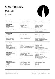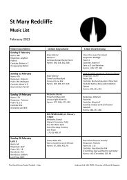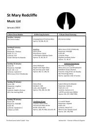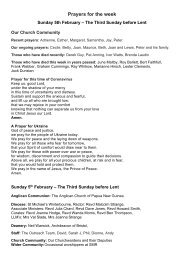
St Mary Redcliffe Project 450 Planning Pre-App

You also want an ePaper? Increase the reach of your titles
YUMPU automatically turns print PDFs into web optimized ePapers that Google loves.
2.0 SITE CONTEXT<br />
2.3 HISTORIC EVOLUTION<br />
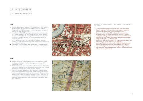
1900<br />
• coinciding broadly with Godwin’s C19 restoration of <strong>St</strong> <strong>Mary</strong> <strong>Redcliffe</strong>,<br />
the buildings to the north of the church have been cleared and<br />
Phippen <strong>St</strong>reet (1850) created as a crescent connecting the base of<br />
Redcliff Hill with Thomas <strong>St</strong>reet;<br />
• the infilling of Redcliff Pit, perhaps necessitated by the introduction<br />
of trams along Redcliff Hill, has reduced the level change between<br />
the street and north porch, leading to the concealment of the north<br />
churchyard boundary wall and the reconfiguration of the porch’s<br />
stepped approach;<br />
• to the east of the church, the south side of Pile <strong>St</strong>reet has been<br />
cleared to create an industrial works, with railway sidings terminating<br />
at the church’s east end;<br />
• the harbour railway has also been created, with a tunnel extending<br />
below the south churchyard to provide a connection to Temple Meads.<br />
In relation to the current context of <strong>St</strong> <strong>Mary</strong> <strong>Redcliffe</strong>, it can therefore be<br />
seen that the:<br />
• south churchyard represents the most intact component of the<br />
church’s setting, yet still records both change over time and the<br />
presence of built structures in proximity to the church;<br />
• church was, until, mid-late C20 embedded in its community;<br />
• visual exposure of the entire north elevation is a C20 construct,<br />
arising from highways decisions; even in the mid-late C19 the form<br />
of Redcliff Hill and Phippen <strong>St</strong>reet would have presented captured<br />
glimpses, rather than elevational totality;<br />
• late C19 and C20 reconfiguration of the steps to the north porch has<br />
undermined the historic primacy of the west end;<br />
• widening of Redcliff Hill and creation of <strong>Redcliffe</strong> Way has severed<br />
<strong>Redcliffe</strong>, isolating the church on an experiential traffic-island;<br />
• post-war developments have created a fragmentary grain that<br />
diminishes both streetscape and urban legibility, producing a hostile<br />
and unwelcoming public realm.<br />
1949<br />
• Oatley’s undercroft (1941) has been constructed at the base of the<br />
north porch, leading to a further reconfiguration of the porch’s<br />
stepped approach;<br />
• Phippen <strong>St</strong>reet has been truncated to enable the creation of <strong>Redcliffe</strong><br />
Way (1936), as a segment of the Inner Circuit Road, and is earmarked<br />
for complete demolition to form the surface carpark;<br />
• <strong>Redcliffe</strong> has suffered significant Blitz damage, although arguably<br />
more damaging still are the proposals to widen Redcliff Hill (shown<br />
red), necessitating the demolition of the entire west side of the street,<br />
including the at-least nationally significant Lead Shot Tower, and the<br />
comprehensive clearance of South <strong>Redcliffe</strong> (shown yellow) to create<br />
the social housing estates of Francombe House (1960) and <strong>Pre</strong>wett<br />
<strong>St</strong>reet (1955-66).<br />
17