
Create successful ePaper yourself
Turn your PDF publications into a flip-book with our unique Google optimized e-Paper software.
Dear homeowner, flood<br />
letters on the way<br />
Thousands of <strong>Hamilton</strong> properties could<br />
be tagged as at risk of flooding as council<br />
bosses work to identify the impact of a major<br />
storm on the city.<br />
BY AARON LEAMAN<br />
Letters are already being<br />
sent to about 1600<br />
landowners in the city’s<br />
south after their properties<br />
were identified as being<br />
impacted by flooding in a<br />
one-in-100-year event.<br />
The information is captured<br />
in a new mapping tool being<br />
trialled by the city council and<br />
shared online.<br />
Explaining what the flood<br />
mapping means for households<br />
looms as a must-do for<br />
council bosses after an earlier<br />
flood risk project caused widespread<br />
panic.<br />
In 2012, more than 28,000<br />
<strong>Hamilton</strong> properties received<br />
letters from the council warning<br />
that their homes were at<br />
risk of flooding.<br />
The letters were deliberately<br />
vague to prevent panic but the<br />
strategy backfired as ratepayers<br />
responded with scorn and confusion.<br />
It eventually prompted<br />
a public apology from then<br />
mayor Julie Hardaker.<br />
The latest flood information<br />
models how a “very large<br />
rain event” would impact<br />
the city’s Mangakōtukutuku<br />
catchment which takes in the<br />
suburbs of Melville, Glenview,<br />
Deanwell, Bader, Fitzroy and<br />
Peacocke. The mapping identifies<br />
flood hazards as low, medium<br />
or high.<br />
To meet requirements laid<br />
out by the Waikato Regional<br />
Council, the city council has<br />
an ongoing programme to<br />
understand the impact a oncein-a-century<br />
storm would have<br />
on the city. To date, the flood<br />
mapping has been applied to<br />
about one third of <strong>Hamilton</strong>.<br />
The chance of a one-in-100-<br />
year flood happening in any<br />
one year is one per cent. The<br />
last 100-year flood struck <strong>Hamilton</strong><br />
in 1958.<br />
City Councillor Martin Gallagher<br />
said elected members<br />
were briefed on the flood mapping<br />
project which wasn’t the<br />
case back in 2012.<br />
Gallagher has memories of<br />
the 1958 flood in <strong>Hamilton</strong><br />
and recalls one end of Radnor<br />
Street being flooded.<br />
The Waikato River was last at<br />
a 100-year flood level in 1998.<br />
Previously, flood hazard mapping<br />
has featured in the city<br />
council’s district plan. The new<br />
flood mapping uses a more upto-date<br />
process, which factors<br />
in climate change information,<br />
and will be included on properties’<br />
LIM reports.<br />
Flood letters started being<br />
mailed out to residents on<br />
Monday. All the letters will be<br />
22 <strong>Hamilton</strong> greypower Magazine | <strong>March</strong> <strong>2021</strong><br />
sent by mid-December – including<br />
200 letters sent to Rotokauri<br />
residents with updated<br />
flood mapping.<br />
<strong>Hamilton</strong> Mayor Paula<br />
Southgate has had oversight<br />
over the letter mail-out and<br />
said her focus is on clear communication<br />
with residents.<br />
“I’ve talked to staff about<br />
putting the technical information<br />
into very plain language<br />
so that people understand that<br />
the risk is low to their properties<br />
but, even still, we’re obliged to<br />
note that risk,” Southgate said.<br />
Because of her background<br />
serving on the Waikato<br />
Regional Council, Southgate<br />
said she understands the need<br />
to identify flood risk areas<br />
across the city.<br />
“I think it’s only right that<br />
people understand the risks<br />
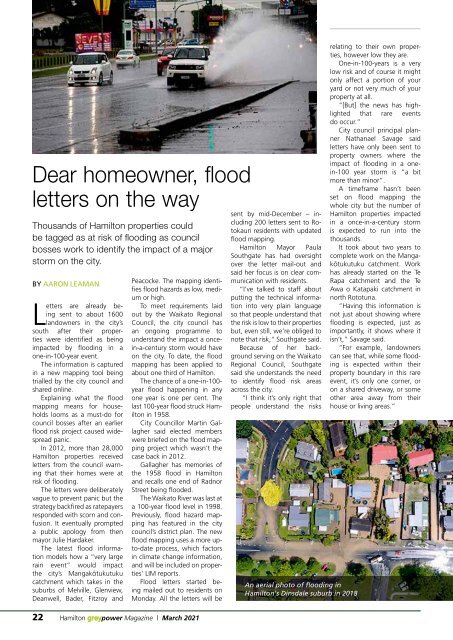
An aerial photo of flooding in<br />
<strong>Hamilton</strong>'s Dinsdale suburb in 2018<br />
relating to their own properties,<br />
however low they are.<br />
One-in-100-years is a very<br />
low risk and of course it might<br />
only affect a portion of your<br />
yard or not very much of your<br />
property at all.<br />
“[But] the news has highlighted<br />
that rare events<br />
do occur.”<br />
City council principal planner<br />
Nathanael Savage said<br />
letters have only been sent to<br />
property owners where the<br />
impact of flooding in a onein-100<br />
year storm is “a bit<br />
more than minor”.<br />
A timeframe hasn’t been<br />
set on flood mapping the<br />
whole city but the number of<br />
<strong>Hamilton</strong> properties impacted<br />
in a once-in-a-century storm<br />
is expected to run into the<br />
thousands.<br />
It took about two years to<br />
complete work on the Mangakōtukutuku<br />
catchment. Work<br />
has already started on the Te<br />
Rapa catchment and the Te<br />
Awa o Katapaki catchment in<br />
north Rototuna.<br />
“Having this information is<br />
not just about showing where<br />
flooding is expected, just as<br />
importantly, it shows where it<br />
isn’t,” Savage said.<br />
“For example, landowners<br />
can see that, while some flooding<br />
is expected within their<br />
property boundary in this rare<br />
event, it’s only one corner, or<br />
on a shared driveway, or some<br />
other area away from their<br />
house or living areas.”