Times of the Islands Fall 2021
Presents the "soul of the Turks & Caicos Islands" with in-depth features about local people, culture, history, environment, real estate, businesses, resorts, restaurants and activities.
Presents the "soul of the Turks & Caicos Islands" with in-depth features about local people, culture, history, environment, real estate, businesses, resorts, restaurants and activities.

You also want an ePaper? Increase the reach of your titles
YUMPU automatically turns print PDFs into web optimized ePapers that Google loves.
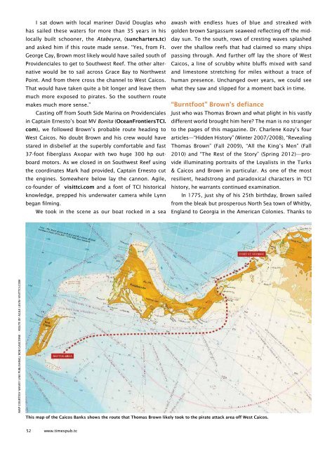
I sat down with local mariner David Douglas who<br />
has sailed <strong>the</strong>se waters for more than 35 years in his<br />
locally built schooner, <strong>the</strong> Atabeyra, (suncharters.tc)<br />
and asked him if this route made sense. “Yes, from Ft.<br />
George Cay, Brown most likely would have sailed south <strong>of</strong><br />
Providenciales to get to Southwest Reef. The o<strong>the</strong>r alternative<br />
would be to sail across Grace Bay to Northwest<br />
Point. And from <strong>the</strong>re cross <strong>the</strong> channel to West Caicos.<br />
That would have taken quite a bit longer and leave <strong>the</strong>m<br />
much more exposed to pirates. So <strong>the</strong> sou<strong>the</strong>rn route<br />
makes much more sense.”<br />
Casting <strong>of</strong>f from South Side Marina on Providenciales<br />
in Captain Ernesto’s boat MV Bonita (OceanFrontiersTCI.<br />
com), we followed Brown’s probable route heading to<br />
West Caicos. No doubt Brown and his crew would have<br />
stared in disbelief at <strong>the</strong> superbly comfortable and fast<br />
37-foot fiberglass Axopar with two huge 300 hp outboard<br />
motors. As we closed in on Southwest Reef using<br />
<strong>the</strong> coordinates Mark had provided, Captain Ernesto cut<br />
<strong>the</strong> engines. Somewhere below lay <strong>the</strong> cannon. Agile,<br />
co-founder <strong>of</strong> visittci.com and a font <strong>of</strong> TCI historical<br />
knowledge, prepped his underwater camera while Lynn<br />
began filming.<br />
We took in <strong>the</strong> scene as our boat rocked in a sea<br />
awash with endless hues <strong>of</strong> blue and streaked with<br />
golden brown Sargassum seaweed reflecting <strong>of</strong>f <strong>the</strong> midday<br />
sun. To <strong>the</strong> south, rows <strong>of</strong> cresting waves splashed<br />
over <strong>the</strong> shallow reefs that had claimed so many ships<br />
passing through. And fur<strong>the</strong>r <strong>of</strong>f lay <strong>the</strong> shore <strong>of</strong> West<br />
Caicos, a line <strong>of</strong> scrubby white bluffs mixed with sand<br />
and limestone stretching for miles without a trace <strong>of</strong><br />
human presence. Unchanged over years, we could see<br />
what <strong>the</strong>y saw and slipped for a moment back in time.<br />
“Burntfoot” Brown’s defiance<br />
Just who was Thomas Brown and what plight in his vastly<br />
different world brought him here? The man is no stranger<br />
to <strong>the</strong> pages <strong>of</strong> this magazine. Dr. Charlene Kozy’s four<br />
articles—“Hidden History” (Winter 2007/2008), “Revealing<br />
Thomas Brown” (<strong>Fall</strong> 2009), “All <strong>the</strong> King’s Men” (<strong>Fall</strong><br />
2010) and “The Rest <strong>of</strong> <strong>the</strong> Story” (Spring 2012)—provide<br />
illuminating portraits <strong>of</strong> <strong>the</strong> Loyalists in <strong>the</strong> Turks<br />
& Caicos and Brown in particular. As one <strong>of</strong> <strong>the</strong> most<br />
resilient, headstrong and paradoxical characters in TCI<br />
history, he warrants continued examination.<br />
In 1775, just shy <strong>of</strong> his 25th birthday, Brown sailed<br />
from <strong>the</strong> bleak but prosperous North Sea town <strong>of</strong> Whitby,<br />
England to Georgia in <strong>the</strong> American Colonies. Thanks to<br />
MAP COURTESY WAVEY LINE PUBLISHING/ BOB GASCOINE • ROUTE BY AGILE LEVIN–VISITTCI.COM<br />
This map <strong>of</strong> <strong>the</strong> Caicos Banks shows <strong>the</strong> route that Thomas Brown likely took to <strong>the</strong> pirate attack area <strong>of</strong>f West Caicos.<br />
52 www.timespub.tc