The International DORIS Service July 2003 – December 2005 report
The International DORIS Service July 2003 – December 2005 report
The International DORIS Service July 2003 – December 2005 report

Create successful ePaper yourself
Turn your PDF publications into a flip-book with our unique Google optimized e-Paper software.
<strong>The</strong> <strong>International</strong> <strong>DORIS</strong> <strong>Service</strong><br />
<strong>July</strong> <strong>2003</strong> <strong>–</strong> <strong>December</strong> <strong>2005</strong> <strong>report</strong><br />
G. Tavernier (1), H. Fagard (2), M. Feissel-Vernier (3,4), F. Lemoine (5), C. Noll (5), R. Noomen<br />
(6), J.C. Ries (7), L. Soudarin (8), J.J. Valette (8), P. Willis (9,10)<br />
(1) Centre National d’Etudes Spatiales, 18 Avenue Edouard Belin, 31401 Toulouse Cedex 9,<br />
France<br />
(2) Institut Géographique National, <strong>Service</strong> de la Géodesie et du Nivellement, 2 Avenue<br />
Pasteur, 94165 Saint-Mandé CEDEX, France<br />
(3) Observatoire de Paris, SYRTE, 61, avenue de l’Observatoire, 75014 Paris, France<br />
(4) Institut Géographique National, LAREG, 6-8 Avenue B. Pascal, 77455 Marne-la-Vallée,<br />
France<br />
(5) NASA Goddard Space Flight Center, Greenbelt, Maryland, USA<br />
(6) DEOS, Delft University of Technology, <strong>The</strong> Netherlands<br />
(7) Center for Space Research, <strong>The</strong> University of Texas, R1000, Austin, TX 78712 USA<br />
(8) Collecte Localisation Satellites, 8-10, rue Hermès, Parc Technologique du Canal, 31520<br />
Ramonville Saint-Agne, France<br />
(9) Institut Géographique National, Direction Technique, 2 Avenue Pasteur, BP 68, 94160<br />
Saint-Mandé, France<br />
(10) Jet Propulsion Laboratory, California Institute of Technology, MS 238-600, 4800 Oak<br />
Grove Drive, Pasadena CA 91109, USA
IDS Report <strong>–</strong> <strong>July</strong> <strong>2003</strong> to <strong>December</strong> <strong>2005</strong> 2<br />
This volume of <strong>report</strong>s is the first <strong>International</strong> <strong>DORIS</strong> <strong>Service</strong> Report documenting the work of<br />
the IDS components between the official IDS acceptance in August <strong>2003</strong> and the end of <strong>2005</strong>.<br />
<strong>The</strong> individual <strong>report</strong>s were contributed by IDS groups in the international geodetic community<br />
who constitute the permanent components of IDS.<br />
<strong>The</strong> IDS <strong>2003</strong>-<strong>2005</strong> Report describes history, changes, activities and progress of the IDS. <strong>The</strong><br />
Governing board and Central Bureau kindly thank all IDS components who contributed to this<br />
Report.<br />
<strong>The</strong> entire contents of this Report also appear on the IDS web site at<br />
http://ids.cls.fr/html/<strong>report</strong>/governing_board.html
IDS Report <strong>–</strong> <strong>July</strong> <strong>2003</strong> to <strong>December</strong> <strong>2005</strong> 3<br />
1 INTRODUCTION.............................................................................................................. 5<br />
2 HISTORY ......................................................................................................................... 6<br />
3 ORGANIZATION.............................................................................................................. 8<br />
3.1 GOVERNING BOARD..................................................................................................... 8<br />
3.2 CENTRAL BUREAU........................................................................................................ 9<br />
4 THE CENTRAL BUREAU: IDS INFORMATION SYSTEM ............................................. 10<br />
4.1 WHAT AND WHERE ..................................................................................................... 10<br />
4.2 WEB AND FTP SITES................................................................................................... 11<br />
4.2.1 IDS WEB SITE................................................................................................................11<br />
4.2.2 IDS FTP SERVER “BASIC INFO”.................................................................................12<br />
4.2.3 <strong>DORIS</strong> WEB SITE ..........................................................................................................12<br />
4.2.4 ANALYSIS COORDINATION WEB SITE ......................................................................12<br />
4.2.5 DATA CENTERS’ WEB SITES ......................................................................................12<br />
4.3 THE MAIL SYSTEM ...................................................................................................... 13<br />
4.3.1 <strong>DORIS</strong>MAIL ....................................................................................................................13<br />
4.3.2 <strong>DORIS</strong>REPORT .............................................................................................................14<br />
4.3.3 IDS ANALYSIS FORUM.................................................................................................14<br />
4.4 HELP TO THE USERS.................................................................................................. 15<br />
4.5 FUTURE PLAN ............................................................................................................. 15<br />
5 THE NETWORK............................................................................................................. 16<br />
5.1 GENERAL STATUS OF THE NETWORK ..................................................................... 16<br />
5.2 RENOVATION PROGRAM OF THE PERMANENT NETWORK ................................... 16<br />
5.3 THIRD GENERATION BEACONS DEPLOYMENT STATUS......................................... 18<br />
5.4 IDS EXPERIMENTS...................................................................................................... 19<br />
5.5 CO-LOCATIONS WITH OTHER IERS TECHNIQUES................................................... 19<br />
6 THE SATELLITES FITTED OUT WITH <strong>DORIS</strong> RECEIVERS ........................................ 21<br />
7 IDS DATA FLOW COORDINATION............................................................................... 23<br />
7.1 FLOW OF IDS DATA AND PRODUCTS ....................................................................... 23<br />
7.2 <strong>DORIS</strong> DATA ................................................................................................................ 25<br />
7.3 <strong>DORIS</strong> PRODUCTS ...................................................................................................... 26<br />
7.4 FUTURE PLANS ........................................................................................................... 27<br />
7.5 IDS DATA CENTERS.................................................................................................... 27<br />
7.5.1 CRUSTAL DYNAMICS DATA INFORMATION SYSTEM (CDDIS)...............................27<br />
7.5.2 INSTITUT GEOGRAPHIQUE NATIONAL (IGN), PARIS FRANCE...............................28<br />
8 ANALYSIS COORDINATION ......................................................................................... 29<br />
8.1 INTRODUCTION........................................................................................................... 29<br />
8.2 IDS DATA AND PRODUCTS......................................................................................... 30<br />
8.2.1 DATA ..............................................................................................................................30<br />
8.2.2 PRODUCTS....................................................................................................................31<br />
8.3 ANALYSIS TOOLS........................................................................................................ 34<br />
8.3.1 CATREF DATA MODELLING AND ANALYSIS.............................................................34<br />
8.3.2 EXTRACTING SEASONAL AND LOW FREQUENCY COMPONENTS: THE<br />
CRONO_VUE ALGORITHM ..........................................................................................34<br />
8.3.3 ALLAN VARIANCE.........................................................................................................34<br />
8.4 THE 2002 ANALYSIS CAMPAIGN ................................................................................ 35<br />
8.5 THE <strong>2003</strong> ANALYSIS CAMPAIGN ................................................................................ 36<br />
8.5.1 SENSITIVITY OF ORBITAL REFERENCE PLANE TO GRAVITY FIELD ....................37<br />
8.5.2 SCALE OF THE <strong>DORIS</strong> TERRESTRIAL REFERENCE FRAMES ...............................37<br />
8.5.3 SENSITIVITY OF TERRESTRIAL REFERENCE FRAMES TO GRAVITY<br />
FIELD AND TO ANALYSIS CENTER ............................................................................39<br />
8.6 <strong>DORIS</strong> OBSERVED GEOCENTER MOTIONS.............................................................. 40<br />
8.6.1 SEASONAL SIGNAL ......................................................................................................41<br />
8.6.2 SPECTRUM....................................................................................................................42<br />
8.7 ANALYSES OF STATION STABILITY........................................................................... 43<br />
8.8 IDS CONTRIBUTIONS TO ITRF <strong>2005</strong> .......................................................................... 44
IDS Report <strong>–</strong> <strong>July</strong> <strong>2003</strong> to <strong>December</strong> <strong>2005</strong> 4<br />
9 REPORT OF THE IGN/JPL ANALYSIS CENTER.......................................................... 46<br />
9.1 CONTEXT ..................................................................................................................... 46<br />
9.2 WEEKLY <strong>DORIS</strong> SOLUTIONS...................................................................................... 46<br />
9.3 DERIVED PRODUCTS. GEOCENTER, EOPS AND CUMULATIVE<br />
SOLUTIONS.................................................................................................................. 48<br />
9.4 CONCLUSIONS ............................................................................................................ 48<br />
10 REPORT OF THE LEGOS/CLS ANALYSIS CENTER ................................................... 49<br />
10.1 SUMMARY........................................................................................................... 49<br />
10.2 DATA PROCESSING.......................................................................................... 49<br />
10.3 PRODUCTS DELIVERED TO IDS ....................................................................... 50<br />
10.4 CAMPAIGN « GRAVITY FIELD COMPARISON »................................................ 51<br />
10.5 PARTICIPATION TO THE GRGS CRC FOR THE IERS ...................................... 51<br />
11 REPORT OF THE INASAN ANALYSIS CENTER .......................................................... 52<br />
11.1 INTRODUCTION.................................................................................................. 52<br />
11.2 PRODUCT AND ANALYSIS RESULTS DESCRIPTIONS .................................... 52<br />
12 REPORT OF THE GEOSCIENCE AUSTRALIA/NASA GSFC ANALYSIS<br />
CENTER ........................................................................................................................ 53<br />
12.1 INTRODUCTION.................................................................................................. 53<br />
12.2 GRAVITY MODEL TESTS (DESCRIPTIONS)...................................................... 53<br />
12.3 GRAVITY MODEL TESTS (RESULTS)................................................................ 54<br />
12.4 SINEX SERIES SUBMITTED TO THE CDDIS ..................................................... 55<br />
13 REPORT OF THE OBSERVATORY PECNY ANALYSIS CENTER ............................... 56<br />
14 CONCLUSION ............................................................................................................... 57<br />
15 PUBLICATIONS (<strong>2003</strong>-<strong>2005</strong>)......................................................................................... 58<br />
15.1 PEER-REVIEWED PUBLICATIONS .................................................................... 58<br />
15.2 OTHER PUBLICATIONS...................................................................................... 59<br />
16 REFERENCES............................................................................................................... 61
1 INTRODUCTION<br />
IDS Report <strong>–</strong> <strong>July</strong> <strong>2003</strong> to <strong>December</strong> <strong>2005</strong> 5<br />
In <strong>2003</strong>, the IERS changed its name to the <strong>International</strong> Earth rotation and Reference system<br />
<strong>Service</strong> and reorganized its structure. <strong>The</strong> IERS now assumes that all space geodetic<br />
techniques manage the data collection and intra-technique combinations within their respective<br />
services and that the IERS will only perform the inter-technique combinations of their specific<br />
products (Rothacher et al. 2004): Earth Orientation Parameters (EOP), and Terrestrial<br />
Reference Frame (TRF). Most space-techniques were already organized into services in the<br />
<strong>2003</strong> timeframe: the <strong>International</strong> GNSS <strong>Service</strong> (IGS) for GPS, GLONASS and, in the future,<br />
Galileo (Beutler et al. 1999), the <strong>International</strong> Laser Ranging <strong>Service</strong> (ILRS) for both satellite<br />
laser ranging and lunar laser ranging (Pearlman et al. 2002) and the <strong>International</strong> VLBI <strong>Service</strong><br />
for Geodesy and Astrometry (IVS) for geodetic radio-interferometry (Schlueter et al. 2002). This<br />
organization by technique is fundamental to meet the scientific goals of the newly created<br />
project of the <strong>International</strong> Association of Geodesy (IAG), now called Global Geodetic<br />
Observing System (GGOS) (Rummel et al. <strong>2005</strong>; Willis et al. <strong>2005</strong>).<br />
However, there was no IAG service to federate the research and developments related to the<br />
<strong>DORIS</strong> technique. An <strong>International</strong> <strong>DORIS</strong> <strong>Service</strong> was thus created in <strong>2003</strong> to organize the<br />
expected <strong>DORIS</strong> contribution to IERS and GGOS and to foster a larger international<br />
cooperation on this topic. At present, more than 50 groups from 35 different countries<br />
participate in the IDS at various levels, including 43 groups hosting <strong>DORIS</strong> stations in 32<br />
countries all around the globe. Four analysis groups provide results, such as weekly or monthly<br />
station coordinates, geocentre variations or Earth polar motion that will be used soon to<br />
generate IDS combined products for geodesy or geodynamics.
2 HISTORY<br />
IDS Report <strong>–</strong> <strong>July</strong> <strong>2003</strong> to <strong>December</strong> <strong>2005</strong> 6<br />
<strong>The</strong> <strong>DORIS</strong> system was designed and developed by CNES, the French space agency, in<br />
partnership with the space geodesy research institute GRGS and France’s mapping and survey<br />
agency IGN for precise orbit determination of altimeter missions and consequently also for<br />
geodetic ground station positioning (Tavernier et al. <strong>2003</strong>).<br />
<strong>DORIS</strong> joined the GPS, laser and VLBI techniques as a contributor to the IERS in the<br />
framework of ITRF-94. In order to collect, merge, analyze, archive and distribute observation<br />
data sets and products, the IGS was established and recognized as a scientific service of the<br />
IAG in 1994, followed by the ILRS in 1998 and the IVS in 1999. It is clear that <strong>DORIS</strong> has<br />
benefited from the experience gained by these earlier services.<br />
<strong>The</strong>re was an increasing demand in the late nineties among the international scientific<br />
community, particularly the IAG and the IERS, for a similar service dedicated to the <strong>DORIS</strong><br />
technique.<br />
On the occasion of the CSTG (Coordination of Space Technique in Geodesy) and IERS<br />
Directing Board meetings, held during the IUGG General Assembly in Birmingham in <strong>July</strong> 1999,<br />
it was decided to initiate a <strong>DORIS</strong> Pilot Experiment (Tavernier et al. 2002) that could lead on the<br />
long-term to the establishment of such an IDS. A joint CSTG/IERS Call for Participation in the<br />
<strong>DORIS</strong> Pilot Experiment was issued on 10 September 1999. An international network of 54<br />
tracking stations was then contributing to the system and 11 proposals for new <strong>DORIS</strong> stations<br />
were submitted. Ten proposals were submitted for Analysis Centers (ACs). Two Global Data<br />
Centers (NASA/CDDIS in USA and IGN/LAREG in France) already archived <strong>DORIS</strong><br />
measurements and were ready to archive IDS products. <strong>The</strong> Central Bureau was established at<br />
the CNES Toulouse Centre, as a joint initiative between CNES, CLS (Collecte Localisation<br />
Satellites) and IGN (Institut Géographique National).<br />
<strong>The</strong> IDS Central Bureau and the Analysis Coordinator initiated several Analysis Campaigns<br />
(see chapter 8 about Pilot and early IDS campaigns).<br />
Several meetings were organized in the framework of the <strong>DORIS</strong> Pilot Experiment:<br />
- <strong>DORIS</strong> Days were held in Toulouse in May 2000 (see programme and contributions in<br />
http://ids.cls.fr/html/<strong>report</strong>/doris_days_2000/programme.html),<br />
- an IDS Workshop was held in Biarritz in June 2002 (see programme and contributions in<br />
http://lareg.ensg.ign.fr/IDS/events/biarritz.html),<br />
- an IDS Analysis Workshop was held in Marne La Vallée in February <strong>2003</strong> (see<br />
programme and contributions in http://lareg.ensg.ign.fr/IDS/events/prog_<strong>2003</strong>.html).
IDS Report <strong>–</strong> <strong>July</strong> <strong>2003</strong> to <strong>December</strong> <strong>2005</strong> 7<br />
<strong>The</strong> IDS was officially started on <strong>July</strong> 1, <strong>2003</strong> as an IAG <strong>Service</strong> after the decision of the IAG<br />
Executive Committee at the IUGG General Assembly in Sapporo. <strong>The</strong> first IDS Governing<br />
Board meeting was held on November 18, <strong>2003</strong> in Arles, France. An IDS plenary meeting was<br />
held in Paris in May 2004 (see programme and contributions in<br />
http://lareg.ensg.ign.fr/IDS/events/prog_2004.html).
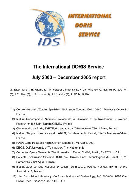
3 ORGANIZATION<br />
IDS Report <strong>–</strong> <strong>July</strong> <strong>2003</strong> to <strong>December</strong> <strong>2005</strong> 8<br />
<strong>The</strong> IDS organization is similar to the organization of other IAG and IERS <strong>Service</strong>s.<br />
Users<br />
data<br />
products<br />
Central<br />
Bureau<br />
3.1 GOVERNING BOARD<br />
Analysis<br />
Centers<br />
Data<br />
Centers<br />
Satellites<br />
(C.C.)<br />
Network<br />
Governing<br />
Board<br />
Analysis<br />
W. Group<br />
Analysis<br />
Coordinator<br />
Data Flow<br />
Coordinator<br />
Stations<br />
Sel. Group<br />
Figure 1. IDS organization<br />
IERS<br />
Dir. Board<br />
IAG<br />
Exec. Com.<br />
Martine Feissel-Vernier retired at the end of October <strong>2005</strong> and left the function of IDS Analysis<br />
Coordinator that she initiated in February 2002. <strong>The</strong> IDS governing board and Central Bureau<br />
would like to friendly and warmly thank Martine Feissel-Vernier for her most valuable<br />
contribution as the first IDS Analysis Coordinator.<br />
Frank Lemoine was elected as Analysis Coordinator in February 2006. He will carry on this<br />
major contribution with the support of the Central Bureau.<br />
Gilles Tavernier CNES Chairperson<br />
Hervé Fagard IGN Network representative<br />
Frank Lemoine NASA GSFC Analysis coordinator<br />
Carey Noll NASA GSFC Data Flow coordinator<br />
Ron Noomen Delft UT Representative of the IERS<br />
John Ries UTEX CSR Member at large
IDS Report <strong>–</strong> <strong>July</strong> <strong>2003</strong> to <strong>December</strong> <strong>2005</strong> 9<br />
Laurent Soudarin CLS Director of the Central Bureau<br />
Pascal Willis IGN / JPL<br />
TBD Stations Selection Group Chairperson & representative of the IAG<br />
3.2 CENTRAL BUREAU<br />
Laurent Soudarin CLS Director<br />
Hervé Fagard IGN<br />
Jean-Pierre Granier CNES<br />
Gilles Tavernier CNES<br />
Jean-Jacques Valette CLS<br />
Pascal Willis IGN / JPL
IDS Report <strong>–</strong> <strong>July</strong> <strong>2003</strong> to <strong>December</strong> <strong>2005</strong> 10<br />
4 THE CENTRAL BUREAU: IDS INFORMATION SYSTEM<br />
Laurent Soudarin (1)<br />
(1) CLS, France<br />
Within the IDS, the information is provided through the web and ftp sites of the Central Bureau,<br />
the Data Centers and the Analysis Coordination, depending on the kind of information. Day-to-<br />
day news of general interest are given to the <strong>DORIS</strong> community by the <strong>DORIS</strong> mail service. <strong>The</strong><br />
<strong>DORIS</strong> <strong>report</strong> and the IDS Analysis Forum mailing lists are devoted to the Analysts. This <strong>report</strong><br />
gives an overview of the IDS information system.<br />
4.1 WHAT AND WHERE<br />
IDS has three data/information centers:<br />
• CB: the Central Bureau web and ftp sites at CLS<br />
• DC: the Data Center(s): * CDDIS: web and ftp sites * IGN: ftp site<br />
• AC: the Analysis Coordinator webpage at IGN/LAREG<br />
<strong>The</strong> baseline storage rules are as follows:<br />
DC store observational data and products + formats and analysis descriptions. <strong>The</strong> DCs will<br />
issue monthly bulletins (with respective dates shifted by 1/2 month) giving the current status of<br />
the data and product storage. .<br />
CB produces/stores/maintains basic information on the <strong>DORIS</strong> system, including various<br />
standard models (satellites, receivers, signal, reference frames, etc). .<br />
AC refers to CB and DC information on the data and modelling, and generates/stores analyses<br />
of the products.<br />
Two criteria are considered for deciding where files are stored/maintained:<br />
1. the responsibility on their content and updating,<br />
2. the easiness of user access.<br />
Data-directed software is stored and maintained at the CB, analysis-directed software is<br />
stored/maintained, or made accessible through the AC site.<br />
To avoid information inconsistencies, duplication is minimized. Logical links and cross<br />
referencing between the three types of information centers is systematically used.
4.2 WEB AND FTP SITES<br />
4.2.1 IDS WEB SITE<br />
address : http://ids.cls.fr<br />
IDS Report <strong>–</strong> <strong>July</strong> <strong>2003</strong> to <strong>December</strong> <strong>2005</strong> 11<br />
<strong>The</strong> IDS web site gives general information on the <strong>Service</strong>, and on the <strong>DORIS</strong> system (link : all<br />
about <strong>DORIS</strong>). It is composed of the following headings:<br />
• About IDS: general information about the service<br />
• Organization: structure of the service, terms of reference, components<br />
• Events: links to meeting, workshop, assembly announcement<br />
• Data centers: access information to the IDS Data Centers<br />
• Reports: IDS documents, <strong>DORIS</strong> bibliography, meeting presentations, <strong>DORIS</strong>-related<br />
peer-reviewed publications, mail system messages, citation rules, etc.<br />
• Contacts and links: information about related activities<br />
It is also supplemented by a site index, FAQs, news on the IDS and news on <strong>DORIS</strong>.<br />
<strong>The</strong> heading « All about <strong>DORIS</strong> » gives access to important information useful for the users:<br />
• the Site logs of the network stations<br />
• the System Events file<br />
• time series of station coordinates<br />
• satellite and station daily performance plots<br />
This site is maintained by the Central Bureau.<br />
1000<br />
900<br />
800<br />
700<br />
600<br />
500<br />
400<br />
300<br />
200<br />
100<br />
0<br />
2 193212 29302832<br />
67616960 Mar-00<br />
May-00<br />
Jul-00<br />
Sep-00<br />
Nov-00<br />
Jan-01<br />
Mar-01<br />
141<br />
113 116121103<br />
67<br />
# access per month (CNES and CLS excluded)<br />
11115110 127<br />
164 188<br />
226<br />
208209<br />
May-01<br />
Jul-01<br />
Sep-01<br />
Nov-01<br />
Jan-02<br />
394<br />
298<br />
279<br />
257<br />
236 245<br />
256<br />
204<br />
177<br />
155<br />
300 362<br />
337<br />
312 320<br />
277<br />
134<br />
380 368 387 378370<br />
326<br />
248<br />
335362 440<br />
428 432<br />
377 369<br />
346<br />
Mar-02<br />
May-02<br />
Jul-02<br />
Sep-02<br />
Nov-02<br />
Jan-03<br />
Mar-03<br />
May-03<br />
Jul-03<br />
Sep-03<br />
Nov-03<br />
Jan-04<br />
Mar-04<br />
May-04<br />
Jul-04<br />
488<br />
591<br />
541542546 562<br />
624<br />
79796<br />
879<br />
Sep-04<br />
Nov-04<br />
Jan-05<br />
Mar-05<br />
May-05<br />
Jul-05<br />
Sep-05<br />
Nov-05<br />
Figure 2. IDS web site number of access per month (CNES and CLS excluded)
4.2.2 IDS FTP SERVER “BASIC INFO”<br />
address: ftp://ftp.cls.fr/pub/ids<br />
IDS Report <strong>–</strong> <strong>July</strong> <strong>2003</strong> to <strong>December</strong> <strong>2005</strong> 12<br />
<strong>The</strong> IDS ftp server gives basic information on the <strong>DORIS</strong> system. It concerns:<br />
• the centers: presentation and analysis strategy of the ACs<br />
• the data: format description 1.0 and 2.1<br />
• the dorimails and doris<strong>report</strong>s: archive of the messages and indexes<br />
• the products: format of eop, geoc, snx, sp1,stcd<br />
• the satellites: macromodels, nominal attitude model, maneuver histories, arcs/cycles<br />
calendar with maneuver types<br />
• the stations: ties, colocations, host agencies, ITRF2000, antennas description, Jason<br />
visibility<br />
This site is maintained by the Central Bureau.<br />
<strong>The</strong>re’s a mirror site at CDDIS: ftp://cddisa.gsfc.nasa.gov/pub/doris/cb_mirror/<br />
4.2.3 <strong>DORIS</strong> WEB SITE<br />
Address: http://www.jason.oceanobs.com/html/doris/<br />
<strong>The</strong> official <strong>DORIS</strong> web site is hosted by the Aviso website which is dedicated to altimetry,<br />
orbitography and precise location missions. <strong>The</strong> <strong>DORIS</strong> pages present the principle and the<br />
applications of the system. Technical information will be added.<br />
This site is maintained by the Aviso webmaster with the support of the IDS Central Bureau.<br />
4.2.4 ANALYSIS COORDINATION WEB SITE<br />
Address: http://lareg.ensg.ign.fr/IDS<br />
<strong>The</strong> Analysis coordinator maintains a website which provides information and discussion areas<br />
about the analysis strategies and models, and analyses of the products of the Analysis Centers.<br />
See the <strong>report</strong> of the Analysis Coordinator.<br />
4.2.5 DATA CENTERS’ WEB SITES<br />
Data and products, formats and analysis descriptions are stored at the CDDIS and IGN Data<br />
Centers. A detailed description is given in the <strong>report</strong> of the Data flow Coordinator.<br />
Address of the CDDIS web site: http://cddis.gsfc.nasa.gov/doris_datasum.html<br />
Address of the CDDIS ftp site: ftp://cddis.gsfc.nasa.gov/doris/<br />
Address of the IGN ftp site: ftp://lareg.ensg.ign.fr/pub/doris/
4.3 THE MAIL SYSTEM<br />
IDS Report <strong>–</strong> <strong>July</strong> <strong>2003</strong> to <strong>December</strong> <strong>2005</strong> 13<br />
In May 1996, in the frame of the IERS <strong>DORIS</strong> Coordination activities, IGN has set up the<br />
<strong>DORIS</strong>mail service to send general information for a large <strong>DORIS</strong> audience. This mailing list<br />
became then one of the communication tool of the IDS. In October 2004, two new lists were<br />
created, dedicated to information and discussion specific to the analysis: the <strong>DORIS</strong><strong>report</strong> and<br />
the IDS Analysis Forum.<br />
A description of the mailing lists can be found on the IDS web site on the page:<br />
http://ids.cls.fr/html/<strong>report</strong>/doris_mails.html<br />
4.3.1 <strong>DORIS</strong>MAIL<br />
e-mail: dorismail@cls.fr (replacing the original dorismail@ensg.ign.fr)<br />
<strong>The</strong> <strong>DORIS</strong>mails are used to distribute messages of general interest to the users’ community<br />
(175 subscribers). <strong>The</strong> messages concern:<br />
• Network evolution: installation, renovation…<br />
• Data delivery: lack of data, maneuver files<br />
• Satellite status<br />
• Status of the Data Centers<br />
• Meeting announcements<br />
• Calls for participation<br />
• delivery by Analysis Centers<br />
• etc…<br />
<strong>The</strong> messages are moderated by the Central Bureau.<br />
<strong>The</strong>y are all archived on the mailing list server of IGN/ENSG at the following address:<br />
http://list.ensg.ign.fr/wws/arc/dorismail<br />
<strong>The</strong>y are also available in text format on the IDS ftp site:<br />
ftp://ftp.cls.fr/pub/ids/dorismail/
80<br />
70<br />
60<br />
50<br />
40<br />
30<br />
20<br />
10<br />
0<br />
IDS Report <strong>–</strong> <strong>July</strong> <strong>2003</strong> to <strong>December</strong> <strong>2005</strong> 14<br />
# of <strong>DORIS</strong>mail per year<br />
1996 1997 1998 1999 2000 2001 2002 <strong>2003</strong> 2004 <strong>2005</strong><br />
Figure 3. 436 <strong>DORIS</strong>mails were distributed between May 1996 and <strong>December</strong> <strong>2005</strong><br />
4.3.2 <strong>DORIS</strong>REPORT<br />
e-mail : doris<strong>report</strong>@cls.fr<br />
This list is used for regular <strong>report</strong>s from Analysis Centers, from the Analysis coordination and<br />
from the CNES POD team. <strong>The</strong> <strong>DORIS</strong>Report distribution list is composed by Analysis Centers,<br />
Data Centers, IDS Governing Board and Central Bureau, CNES POD people delivering data to<br />
the Data Centers (30 subscribers).<br />
95 messages were distributed in 2004, 360 in <strong>2005</strong>. <strong>The</strong>y are all archived on the mailing list<br />
server of CLS at the following address:<br />
http://listes.cls.fr/wws/arc/doris<strong>report</strong><br />
<strong>The</strong>y are also available in text format on the IDS ftp site:<br />
ftp://ftp.cls.fr/pub/ids/doris<strong>report</strong>/<br />
<strong>The</strong> list is moderated by the Central Bureau and the CNES POD people.<br />
4.3.3 IDS ANALYSIS FORUM<br />
e-mail : ids.analysis.forum@cls.fr<br />
In order to share in the present, and secure for the future, information, questions and answers<br />
on the problems encountered in the <strong>DORIS</strong> data analysis, the Analysis Coordinator with the<br />
support of the Central Bureau initiated the IDS Analysis Forum. This a list for discussion of<br />
<strong>DORIS</strong> data analysis topics (stations, satellites, <strong>DORIS</strong> instruments, data, analysis, orbits, EOP,<br />
products) moderated by the Analysis Coordination (Martine Feissel-Vernier, Jean-Jacques<br />
Valette and Laurent Soudarin, in France) and John Ries (in the USA).<br />
<strong>The</strong> messages are all archived on the mailing list server of CLS at the following address:
IDS Report <strong>–</strong> <strong>July</strong> <strong>2003</strong> to <strong>December</strong> <strong>2005</strong> 15<br />
http://listes.cls.fr/wws/arc/ids.analysis.forum<br />
Previous to the creation of forum, the Analysis Coordinator has collected 68 messages of<br />
conversion between analysts in an archive that can be viewed at:<br />
http://lareg.ensg.ign.fr/IDS/disc.html<br />
4.4 HELP TO THE USERS<br />
e-mail : IDS.central.bureau@cls.fr<br />
<strong>The</strong> contact point for every information requirement is the Central Bureau. It will find a solution<br />
to respond to user’s need. A list of contact points has been defined for internal use depending<br />
on the kind of questions.<br />
Since <strong>2003</strong>, many exchanges took place with the Analysis Centers and groups which are<br />
expected to contribute soon to the IDS (AIUB, Observatory of Pecny, IAA, GSFC, Geoscience<br />
Australia).<br />
4.5 FUTURE PLAN<br />
Sections of the IDS Websites will be revised in the near future. <strong>The</strong> homepage will be improved<br />
to give a better access to the information. Information from the Analysis Coordination Web<br />
pages will be included in the IDS Website. <strong>The</strong> station site-log pages will be supplemented by<br />
other information relative to the IDS tracking network, such as coordinate time-series and local<br />
events related to seismic or volcanic activity. In the area of data analysis, new products, such as<br />
satellite orbits, as well as additional contribution for existing products, such as time-series of the<br />
geocenter and of EOPs, will be provided to the IDS by the Analysis Centers. <strong>The</strong> Central<br />
Bureau will continue to support any new ACs as they join the service.
5 THE NETWORK<br />
5.1 GENERAL STATUS OF THE NETWORK<br />
IDS Report <strong>–</strong> <strong>July</strong> <strong>2003</strong> to <strong>December</strong> <strong>2005</strong> 16<br />
Hervé Fagard (1)<br />
(1) IGN, France<br />
<strong>The</strong> stations that are currently part of the ground segment of the <strong>DORIS</strong> system can be divided<br />
in two groups:<br />
• <strong>The</strong> “permanent stations”, whose primary purpose is to take part in the orbit<br />
determination for the satellites carrying <strong>DORIS</strong> instruments. Such stations were installed<br />
for an a priori unlimited time period, following an initial CNES and IGN proposal.<br />
Nevertheless some circumstances may require that we have to remove a station and<br />
look for another host agency.<br />
• <strong>The</strong> “IDS stations”, which have been installed following proposals submitted by other<br />
organizations with varied scientific motivations, for a limited or undefined time period.<br />
Figure 4 shows the status of the permanent network at the end of <strong>2005</strong>, and the IDS<br />
experiments that have been operating sometime in 2004 and/or <strong>2005</strong>.<br />
Figure 4. IDS experiments in 2004 and <strong>2005</strong><br />
5.2 RENOVATION PROGRAM OF THE PERMANENT NETWORK<br />
<strong>The</strong> current status of the <strong>DORIS</strong> permanent network, as regards the antenna stability, is shown<br />
on figure 5. <strong>The</strong> stations renovation program, initiated in 2000 in order to improve the long term<br />
stability of the antenna support, was continued, as illustrated in figure 6.<br />
In 2004 the following stations were renovated:
• Mount Stromlo (Australia)<br />
• Cachoeira Paulista (Brazil)<br />
• Marion Island (South Africa)<br />
• Badary (Russia)<br />
• Yuzhno-Sakhalinsk (Russia)<br />
• Reykjavik (Iceland)<br />
IDS Report <strong>–</strong> <strong>July</strong> <strong>2003</strong> to <strong>December</strong> <strong>2005</strong> 17<br />
• Kourou (French Guyana): new master beacon.<br />
In <strong>2005</strong> the following stations were renovated:<br />
• Rothera (British base in Antarctica)<br />
• Belgrano (Argentine base in Antarctica). This station, initially installed in 2004 following a<br />
joint AWI-IAA proposal to the IDS, is now included in the <strong>DORIS</strong> permanent network<br />
thanks to its excellent results.<br />
• Nouméa (New-Caledonia)<br />
• Libreville (Gabon)<br />
• Hartebeesthoek (RSA): third master beacon<br />
and the following new stations were installed:<br />
• Male (Maldives), replacing Colombo<br />
• Miami (California, USA), replacing Richmond<br />
• Santa Cruz (Galapagos, Ecuador), replacing Galapagos<br />
• Monument Peak (California, USA), replacing Goldstone<br />
Figure 5. Estimated stability of the <strong>DORIS</strong> permanent stations (end of <strong>2005</strong>)
IDS Report <strong>–</strong> <strong>July</strong> <strong>2003</strong> to <strong>December</strong> <strong>2005</strong> 18<br />
Figure 6. <strong>DORIS</strong> permanent network renovation<br />
At the end of <strong>2005</strong>, 47 out of 56 stations (in the permanent orbitography network) are<br />
considered to have good or excellent stability.<br />
5.3 THIRD GENERATION BEACONS DEPLOYMENT STATUS<br />
<strong>The</strong> deployment of the third generation beacons, which are intended to replace the first and<br />
second generation beacons still operating at many <strong>DORIS</strong> sites, has been interrupted for<br />
several months, after a serial failure on the 2 GHz channel was identified. Half of the beacons<br />
have been affected by this failure, and all units had to be sent back to the manufacturer in order<br />
to be retrofitted. <strong>The</strong> on-site replacement of defective units could only start in October, as<br />
retrofitted beacons became available.<br />
<strong>The</strong> evolution of the proportion of the three beacon types in the permanent network are shown<br />
on figure 7. <strong>The</strong> total number of beacons is lower than 58 because some of the stations whose<br />
closure is planned are not taken into account.
5.4 IDS EXPERIMENTS<br />
IDS Report <strong>–</strong> <strong>July</strong> <strong>2003</strong> to <strong>December</strong> <strong>2005</strong> 19<br />
Figure 7. beacons models in the permanent network<br />
<strong>The</strong> following experiments have been continued or initiated in 2004 (see figure 4):<br />
• <strong>The</strong> second Sorsdal experiment (Glacier movement monitoring in Antarctica) was carried<br />
out by Auslig, from November <strong>2003</strong> to January 2004.<br />
• A new station was installed at Belgrano II, an Argentine base in Antarctica, following a<br />
joint proposal to the IDS by the Alfred Wegener Institute and the Insituto Antárctico<br />
Argentino.<br />
• <strong>The</strong> stations at Wettzell (Germany) and Gavdos (Greece) have been down most of the<br />
time due to a beacon failure.<br />
5.5 CO-LOCATIONS WITH OTHER IERS TECHNIQUES<br />
<strong>The</strong> number of co-locations with currently operating stations of the other techniques contributing<br />
to IERS is as follows.<br />
• GPS: 37 sites<br />
• SLR: 9 sites<br />
• VLBI: 7 sites<br />
<strong>The</strong> following new co-locations were made available in 2004 and <strong>2005</strong>:<br />
• <strong>DORIS</strong>-SLR tie at Jiufeng measured in <strong>December</strong> <strong>2003</strong><br />
• <strong>DORIS</strong>-GPS tie at Yuzhno-Sakhalinsk measured in August 2004<br />
• <strong>DORIS</strong>-VLBI tie at St-John’s measured in <strong>2003</strong>
IDS Report <strong>–</strong> <strong>July</strong> <strong>2003</strong> to <strong>December</strong> <strong>2005</strong> 20<br />
• <strong>DORIS</strong>-GPS tie at Male measured in January <strong>2005</strong><br />
• <strong>DORIS</strong>-GPS tie at Santa Cruz measured in April <strong>2005</strong><br />
• <strong>DORIS</strong>-GPS tie at Monument Peak measured in <strong>December</strong> <strong>2005</strong>, and <strong>DORIS</strong>-SLR tie<br />
derived from the known GPS-SLR tie<br />
Figure 8 shows the distribution of <strong>DORIS</strong> co-locations (
IDS Report <strong>–</strong> <strong>July</strong> <strong>2003</strong> to <strong>December</strong> <strong>2005</strong> 21<br />
6 THE SATELLITES FITTED OUT WITH <strong>DORIS</strong> RECEIVERS<br />
Gilles Tavernier (1)<br />
(1) CNES, France<br />
Initially conceived in the context of the TOPEX/Poseidon mission, the first generation receivers<br />
were flown on four satellites:<br />
- SPOT-2, a CNES remote sensing satellite was launched in 1990, with the first <strong>DORIS</strong><br />
receiver for a 6-month probationary experiment. More than 16 years after the launch, this<br />
receiver is still fully operational,<br />
- TOPEX/Poseidon, a joint venture between CNES and NASA to map ocean surface<br />
topography was launched in 1992. While a 3-year prime mission was planned, with a 5-<br />
year store of expendables, TOPEX/Poseidon has delivered an astonishing 13+ years of<br />
data from orbit: the <strong>DORIS</strong> mission ended with the second receiver failure in November<br />
2004 whereas the ocean surface topography mapping ended in October <strong>2005</strong>,<br />
- SPOT-3 (CNES) was launched in 1993; the spacecraft was lost in November 1996,<br />
- SPOT-4 (CNES) was launched in 1998, featuring the first <strong>DORIS</strong> real time on-board orbit<br />
determination (DIODE).<br />
In the mid-nineties, CNES developed a second generation dual channel <strong>DORIS</strong> receiver which<br />
was miniaturized in the late nineties:<br />
- Jason-1, the CNES/NASA TOPEX follow-on mission was launched on <strong>December</strong> 7, 2001<br />
with a miniaturized second generation <strong>DORIS</strong> receiver. <strong>The</strong> receiver was switched on<br />
<strong>December</strong> 8 and automatically started. <strong>The</strong> orbit accuracy is getting close to one<br />
centimeter on the radial component (Luthcke et al. <strong>2003</strong>; Haines et al. 2004). At the<br />
present time, Jason-1 <strong>DORIS</strong> measurements are not used for geodesy, owing to the<br />
South Atlantic Anomaly (SAA) effect on the on-board Ultra Stable Oscillators (USO)<br />
(Willis et al. 2004), however a correction model has recently been developed (Lemoine<br />
and Capdeville submitted),<br />
- Envisat, the ESA mission to ensure the continuity of the data measurements of the ESA<br />
ERS satellites was launched on March 1, 2002 with a second generation <strong>DORIS</strong><br />
receiver,<br />
- SPOT-5 (CNES) was launched on May 4, 2002 with a miniaturized second generation<br />
<strong>DORIS</strong> receiver.<br />
Figure 9 gives a summary of the satellites providing <strong>DORIS</strong> data to the IDS data centers, as<br />
well as the evolution in time of the number of these satellites. Some of the early SPOT-2 data
IDS Report <strong>–</strong> <strong>July</strong> <strong>2003</strong> to <strong>December</strong> <strong>2005</strong> 22<br />
could not be recovered between 1990 and 1992, due to computer and data format limitations.<br />
With the exception of this time period, all <strong>DORIS</strong>-equipped satellites have provided continuous<br />
data to the IDS data centers. Please note the large increase in the number of <strong>DORIS</strong> satellites<br />
around mid-2002.<br />
Figure 9. <strong>DORIS</strong> observations available at the IDS Data Centers (April 2006).<br />
A <strong>DORIS</strong> (and CERTO) receiver dedicated to global ionospheric measurements should fly on-<br />
board STPSAT1 (Plasma Physics and Space Systems Development Divisions, Naval Research<br />
Laboratory) by the end of 2006 (launch scheduled November 2006).<br />
<strong>The</strong>re won’t be any new launch before 2008:<br />
- Jason-2/OSTM: June 2008<br />
- CryoSat-2: March 2009<br />
- Alti-KA: June 2009
7 IDS DATA FLOW COORDINATION<br />
IDS Report <strong>–</strong> <strong>July</strong> <strong>2003</strong> to <strong>December</strong> <strong>2005</strong> 23<br />
Carey Noll (1)<br />
(1) NASA/GSFC<br />
Two data centers currently support the archiving and access activities for the IDS:<br />
• Crustal Dynamics Data Information System (CDDIS), NASA GSFC, Greenbelt, MD USA<br />
• Institut Géographique National (IGN), Paris France<br />
<strong>The</strong>se institutions have archived <strong>DORIS</strong> data since the launch of TOPEX/Poseidon in 1992.<br />
7.1 FLOW OF IDS DATA AND PRODUCTS<br />
<strong>The</strong> flow of data, products, and information within the IDS is analogous to what is utilized in the<br />
other IAG geodetic services (IGS, ILRS, and IVS) and is shown in Figure 10. IDS data and<br />
products are transmitted from their source to the IDS data centers. <strong>DORIS</strong> data are downloaded<br />
from the satellite at the <strong>DORIS</strong> control and processing center, SSALTO (Segment Sol multi-<br />
missions d'ALTimétrie, d'Orbitographie et de localisation précise) in Toulouse, France. After<br />
validation, SSALTO transmits the data to the IDS data centers (at this time, CDDIS only). IDS<br />
analysis centers as well as other users retrieve these data files from the data centers and<br />
produce products, which in turn are transmitted to the IDS data centers.<br />
Network Stations<br />
Continuously operational<br />
Timely flow of data<br />
Data Centers<br />
Interface to network stations<br />
Perform QC and data conversion<br />
activities<br />
Archive data for access to<br />
analysis centers and users<br />
Analysis Centers<br />
Provide products to users<br />
(e.g., station coordinates, precise<br />
satellite orbits, Earth orientation<br />
parameters, atmos. products, etc.)<br />
Central Bureau/Coordinating Center<br />
Management of service<br />
Facilitate communications<br />
Coordinate activities<br />
Governing Body<br />
General oversight of service<br />
Future direction<br />
Figure 10. Routine flow of data and information for the IAG Geodetic <strong>Service</strong>s
IDS Report <strong>–</strong> <strong>July</strong> <strong>2003</strong> to <strong>December</strong> <strong>2005</strong> 24<br />
<strong>The</strong> IDS data centers use a common structure for directories and filenames that was<br />
implemented in January <strong>2003</strong>. This structure is shown in Table 1 and fully described on the<br />
Analysis Coordinator’s website at http://large.ensg.ign.fr/IDS/doc/struct_dc.html. <strong>The</strong> main<br />
directories are:<br />
• /pub/doris/data (for all data) with subdirectories by satellite code<br />
• /pub/doris/products (for all products) with subdirectories by product type and analysis<br />
center<br />
• /pub/doris/cb_mirror with general information and data and product documentation<br />
(maintained by the IDS Central Bureau)<br />
IGN currently mirrors the contents of the CDDIS data and product archives. Future plans call for<br />
SSALTO to possibly deliver data to both IDS data centers (CDDIS and IGN) to ensure<br />
redundancy in data delivery in the event one data center is unavailable. <strong>The</strong> general information<br />
available through the IDS Central Bureau ftp site are mirrored by the IDS data centers thus<br />
providing users secondary locations for these files.<br />
Table 1. Main Directories for IDS Data and Products<br />
Directory File Name Description<br />
Data Directories<br />
/doris/data/sss sssdataMMM.LLL.Z<br />
sss.files<br />
/doris/data/sss/sum sssdataMMM. LLL.sum.Z<br />
Product Directories<br />
/doris/prodtype/ccc/ orbits/ccc/cccsssVV.bXXDDD.eYYEEE.sp1.L<br />
LL.Z<br />
sinex_global/cccWWuVV.snx.Z<br />
sinex_series/ccc/ cccYYDDDtuVV.snx.Z<br />
stcd/cccWWtu/ cccWWtuVV.stcd.aaaa.Z<br />
geoc/cccWWtuVV.geoc.Z<br />
eop/cccWWtuVV.eop.Z<br />
<strong>DORIS</strong> data for satellite sss, cycle number MMM, and<br />
version LLL<br />
File containing multi-day cycle filenames versus time span<br />
for satellite sss<br />
Summary of contents of <strong>DORIS</strong> data file for satellite sss,<br />
cycle number MMM, and file version number LLL<br />
Satellite orbits in SP1 format from analysis center ccc,<br />
satellite sss, solution version VV, start date year XX and day<br />
DDD, end date year YY and day EEE, and file version<br />
number LLL<br />
Global SINEX solutions of station coordinates for analysis<br />
center ccc, year WW, content u (d=<strong>DORIS</strong>, c=multi-<br />
technique), and solution version VV<br />
Time series SINEX solutions for analysis center ccc, starting<br />
on year YY and day of year DDD, type t (m=monthly,<br />
w=weekly, d=daily) solution, content u (d=<strong>DORIS</strong>, c=multi-<br />
technique), and solution version VV<br />
Station coordinate time series SINEX solutions for analysis<br />
center ccc, for year WW, type t (m=monthly, w=weekly,<br />
d=daily), content u (d=<strong>DORIS</strong>, c=multi-technique), solution<br />
version VV, for station aaaa<br />
TRF origin (geocenter) solutions for analysis center ccc, for<br />
year WW, type t (m=monthly, w=weekly, d=daily), content u<br />
(d=<strong>DORIS</strong>, c=multi-technique), and solution version VV<br />
Earth orientation parameter solutions for analysis center ccc,<br />
for year WW, type t (m=monthly, w=weekly, d=daily), content<br />
u (d=<strong>DORIS</strong>, c=multi-technique), and solution version VV<br />
iono/ccc/sss/ cccsssVV.YYDDD.iono.Z<br />
Information Directories<br />
Ionosphere products for analysis center ccc, satellite sss,<br />
solution version VV, and starting on year YY and day of year<br />
DDD.<br />
/doris/cb_mirror Mirror of IDS central bureau files
7.2 <strong>DORIS</strong> DATA<br />
IDS Report <strong>–</strong> <strong>July</strong> <strong>2003</strong> to <strong>December</strong> <strong>2005</strong> 25<br />
SSALTO deposits <strong>DORIS</strong> data to the CDDIS server cddis.gsfc.nasa.gov. Software at CDDIS<br />
peruses this incoming data area for new files and automatically archives the files to public disk<br />
areas using the directory structure and filenames specified by the IDS. IGN mirrors the CDDIS<br />
<strong>DORIS</strong> data archive thus providing a second identical access point to the IDS community. <strong>The</strong><br />
IDS data centers archive <strong>DORIS</strong> data from five operational satellites (SPOT-2, -4, -5, Jason-1,<br />
and Envisat); data from future missions (e.g., Jason-2, CryoSat-2, Alti-KA…) will be archived<br />
within the IDS. Historic data from SPOT-3 and TOPEX/Poseidon are also available at the data<br />
centers. A summary of <strong>DORIS</strong> data holdings at the IDS data centers is shown in Table 2. <strong>The</strong><br />
<strong>DORIS</strong> data are archived in multi-day (typically 10-day) “cycle” files using the <strong>DORIS</strong> data<br />
format 2.1 (since January 15, 2002). <strong>The</strong> <strong>DORIS</strong> data files are on average two Mbytes in size<br />
(using UNIX compression). SSALTO issues an email notification through <strong>DORIS</strong>Report once<br />
data are delivered to the IDS data centers. <strong>The</strong> average latency of data availability after the last<br />
observation day satellite specific:<br />
• SPOT: ~27 days<br />
• Jason-1: ~22 days<br />
• Envisat: ~35 days<br />
<strong>The</strong> delay by file and satellite is shown in Figure 11.<br />
Table 2. <strong>DORIS</strong> Data Holdings<br />
Satellite Time Span<br />
Envisat 13-Jun-2002 through present<br />
Jason-1 15-Jan-2002 through present<br />
SPOT-2 31-Mar through 04-Jul-1990.<br />
02-Jan through 22-Mar-1992<br />
16-Oct-1992 through present<br />
SPOT-3 01-Feb-1994 through 09-Nov-1996<br />
SPOT-4 01-May-1998 through present<br />
SPOT-5 11-Jun-2002 through present<br />
TOPEX/Poseidon 25-Sep-1992 through 01-Nov-2004
IDS Report <strong>–</strong> <strong>July</strong> <strong>2003</strong> to <strong>December</strong> <strong>2005</strong> 26<br />
Figure 11. Delay in delivery of <strong>DORIS</strong> data to the CDDIS (all satellites, 01/2004-04/2006)<br />
7.3 <strong>DORIS</strong> PRODUCTS<br />
IDS analysis centers utilize similar procedures by putting products to the CDDIS server.<br />
Automated software detects any incoming product files and archives them to the appropriate<br />
product-specific directory. <strong>The</strong> following analysis centers (ACs) have submitted products to the<br />
IDS; their AC code is listed in ():<br />
• NASA GSFC (gsc) USA, F. Lemoine<br />
• Institut Géographique National/JPL (ign) France, P. Willis<br />
• INASAN (ina) Russia, S. Tatevian<br />
• LEGOS/GRGS-CLS (lca) France, J.-F. Crétaux<br />
• CNES/SOD (sod) France, J.P. Berthias<br />
• SSALTO (ssa) France, G. Tavernier<br />
IDS products are archived by type of solution and analysis center. <strong>The</strong> types and sources of<br />
products available through the IDS data centers in <strong>2003</strong>-2004 are shown in Table 3.
IDS Report <strong>–</strong> <strong>July</strong> <strong>2003</strong> to <strong>December</strong> <strong>2005</strong> 27<br />
Table 3. IDS Product Types and Contributing Analysis Centers<br />
Type of Product GSC IGN INA LCA SOD SSA<br />
Time series of SINEX solutions X (W) X (W, M) X (W, M) X (W, M) X (W) X (W,M)<br />
Global SINEX solutions X<br />
Time series of coordinates of the<br />
TRF origin<br />
X (W)<br />
Orbits/satellite X<br />
(Jason)<br />
Ionosphere products/satellite X (All)<br />
Time series of EOP X (W)<br />
Time series of station coordinate X (W) X (M) X (W)<br />
Notes: W=weekly solution<br />
M=monthly solution<br />
7.4 FUTURE PLANS<br />
<strong>The</strong> IDS will investigate the redundant transmission of data and products to both IDS data<br />
centers. This capability would ensure the availability of data and products should either data<br />
center be unavailable. <strong>The</strong> IDS data centers will also investigate procedures to regularly<br />
compare holdings of data and products to ensure that the archives are truly identical. Lastly, the<br />
data centers will investigate the utility of issuing regular <strong>report</strong>s of data holdings through the<br />
<strong>DORIS</strong>Report email system.<br />
7.5 IDS DATA CENTERS<br />
7.5.1 CRUSTAL DYNAMICS DATA INFORMATION SYSTEM (CDDIS)<br />
<strong>The</strong> CDDIS is a dedicated data center supporting the international space geodesy community<br />
since 1982. <strong>The</strong> CDDIS serves as one of the primary data centers for the following IAG<br />
services:<br />
• <strong>International</strong> GPS <strong>Service</strong> (IGS)<br />
• <strong>International</strong> Laser Ranging <strong>Service</strong> (ILRS)<br />
• <strong>International</strong> VLBI <strong>Service</strong> for Geodesy and Astrometry (IVS)<br />
• <strong>International</strong> <strong>DORIS</strong> <strong>Service</strong> (IDS)<br />
• <strong>International</strong> Earth Rotation <strong>Service</strong> (IERS)
IDS Report <strong>–</strong> <strong>July</strong> <strong>2003</strong> to <strong>December</strong> <strong>2005</strong> 28<br />
<strong>The</strong> CDDIS automated software archives data submitted by SSALTO and performs minimal<br />
quality-checks (e.g., file readability, format compliance) resulting in a summary file for each data<br />
file. Software extracts metadata from all incoming <strong>DORIS</strong> data. <strong>The</strong>se metadata include<br />
satellite, time span, station, and number of observations per pass. <strong>The</strong> metadata are loaded into<br />
an Oracle data base and utilized to generate data holding <strong>report</strong>s on a daily basis.<br />
During <strong>2005</strong>, over 180 groups in 48 countries accessed <strong>DORIS</strong> data and information from the<br />
CDDIS.<br />
7.5.1.1 CONTACT<br />
Carey Noll, CDDIS Manager Email: Carey.Noll@nasa.gov<br />
NASA GSFC Voice: 301-614-6542<br />
Code 690.1 Fax: 301-614-6099<br />
Greenbelt, MD 20771 ftp: ftp://cddis.gsfc.nasa.gov/pub/doris<br />
USA WWW: http://cddis.gsfc.nasa.gov<br />
7.5.2 INSTITUT GEOGRAPHIQUE NATIONAL (IGN), PARIS FRANCE<br />
Procedures have been established at IGN to routinely mirror the contents of the data and<br />
product archives at the CDDIS.<br />
7.5.2.1 CONTACT<br />
Bruno Garayt Email: Bruno.Garayt@ensg.ign.fr<br />
ENSG Voice: +33 (0) 1<br />
6-8 avenue Blaise Pascal Fax: +33 (0) 1<br />
77455 Marne-la-Vallée CEDEX 2 ftp: ftp://lareg.ensg.ign.fr/pub/doris<br />
FRANCE WWW: http://lareg.ensg.ign.fr/<strong>DORIS</strong>/index.html
8 ANALYSIS COORDINATION<br />
IDS Report <strong>–</strong> <strong>July</strong> <strong>2003</strong> to <strong>December</strong> <strong>2005</strong> 29<br />
Martine Feissel-Vernier (1,2),<br />
K. Le Bail (2,3), L. Soudarin (4), J.-J. Valette (4)<br />
F.G. Lemoine (5)<br />
(1) Observatoire de Paris, France<br />
(2) Institut Géographique National/LAREG, France<br />
(3) Observatoire de la Côte d'Azur/GEMINI, France<br />
(4) Collecte Localisation Satellites (CLS), France<br />
(5) NASA Goddard Space Flight Center, USA<br />
<strong>The</strong> main products available at IDS after 18 months of existence are time series of Terrestrial<br />
Reference Frames (TRF) and derived parameters at monthly and weekly intervals since 1993.<br />
<strong>The</strong> sets of parameters that are used to qualify the geodetic performance of the <strong>DORIS</strong> system<br />
are series of station coordinates, and series of coordinates of the TRF origin and scale. <strong>The</strong><br />
quality of geodetic results is improving with time, as new <strong>DORIS</strong>-equipped satellites launched in<br />
1994, 1998 and 2002, and network stations rejuvenated starting in 2000. <strong>The</strong> stability of time<br />
series of TRF origin and scale are shown to be sensitive to software and analysis strategies at<br />
the level of a few millimeters. Spurious annual signatures are present up to 1-2 cm in the TRF<br />
origin and 5 mm in the scale. We show that the measurement of station motions has a white<br />
noise error spectrum in the time domain. Over the 1993-2004 time frame, the median stability of<br />
station coordinates for a one year sampling time reaches 5 mm in the horizontal plane as well<br />
as in the vertical direction.<br />
8.1 INTRODUCTION<br />
<strong>The</strong> role of the Analysis Coordinator is defined as follows in the IDS terms of Reference.<br />
“<strong>The</strong> Analysis Coordinator assists the Analysis Centers. <strong>The</strong> Analysis Coordinator monitors the<br />
Analysis Centers activities to ensure that the IDS objectives are carried out. Specific<br />
expectations include quality control, performance evaluation, and continued development of<br />
appropriate analysis standards. <strong>The</strong> Analysis Coordinator, with the assistance of the Central<br />
Bureau, is also responsible for the appropriate combination of the Analysis Centers products<br />
into a single set of products.”
IDS Report <strong>–</strong> <strong>July</strong> <strong>2003</strong> to <strong>December</strong> <strong>2005</strong> 30<br />
In addition to contributing to the improvement in accuracy and consistency of the IDS products,<br />
the Analysis Coordinator is responsible for providing the IDS evaluation of the <strong>DORIS</strong> terrestrial<br />
reference frame (TRF) and Earth Orientation Parameters (EOP) to the IERS.<br />
<strong>The</strong> reference frame topics are discussed with the other providers (GPS, SLR, and VLBI) within<br />
the IERS. <strong>The</strong> international discussion of Doris satellite orbits takes place within the space<br />
oceanography users’ community, in particular through the yearly NASA/CNES Ocean Surface<br />
Topography Science Team Meetings.<br />
<strong>The</strong> IDS data and products are described in section 8.2 and some specific analysis tools are<br />
described in section 8.3. Sections 8.4 and 8.5 summarize the main results obtained in two<br />
analysis campaigns that were initiated in 2002 and in <strong>2003</strong>, concerning the station coordinates<br />
repeatability and the sensitivity of the Terrestrial Reference Frames (TRF) origin and scale to<br />
the gravity field and the analysis strategy and software.<br />
Section 8.6 shows a comparison of the <strong>DORIS</strong>-observed seasonal motion of the TRF origin with<br />
SLR results, and with geophysical prediction of the geocenter motion. Section 8.7 gives an<br />
estimation of the medium term stability of <strong>DORIS</strong>-derived TRFs. <strong>The</strong> results presented in<br />
sections 8.5 and 8.6 are further developed in several presentations at meetings (see section<br />
8.8.2), and in journal articles in preparation.<br />
Sections 8.8 and 8.9 give references to the IDS information Centers and to publications and<br />
communications connected to the IDS Analysis Coordination.<br />
<strong>The</strong> reader may also refer to the position paper “<strong>DORIS</strong> data analysis strategies” by P. Willis<br />
and J.-F. Crétaux (http://lareg.ensg.ign.fr/IDS/events/2004_files/pw-jfc-pp.pdf).<br />
8.2 IDS DATA AND PRODUCTS<br />
8.2.1 DATA<br />
<strong>The</strong> beacon tracking data collected since 1993 by six <strong>DORIS</strong>-equipped satellites, with altitudes<br />
ranging from 800 to 1300 km, are used by IDS for geodetic purposes: Spot 2, 3, 4 & 5 (sp2,<br />
sp3, sp4, sp5), Topex/Poseidon (top), and Envisat (env). Spot 3 was active only until November<br />
1996. <strong>The</strong> <strong>DORIS</strong> receiver on board Topex/Poseidon ceased operation at the end of October<br />
2004. <strong>The</strong> perturbation of the Jason (jas) receiver frequency at each transit of the satellite over<br />
the Southern Atlantic Anomaly region creates a large perturbation of the estimated station<br />
coordinates. <strong>The</strong>refore these data are currently not used to derive IDS products.
IDS Report <strong>–</strong> <strong>July</strong> <strong>2003</strong> to <strong>December</strong> <strong>2005</strong> 31<br />
Figure 12 summarizes the evolution of the performance of the Doris system in terms of the<br />
average scatter over the available network of weekly station coordinates. <strong>The</strong> plotted<br />
parameters are the yearly median standard deviation of series of station coordinates<br />
determinations with respect to the linear trend estimated for the same year. <strong>The</strong> start and end<br />
dates of operation of the satellites are shown. <strong>The</strong> yearly numbers of stations with series of<br />
coordinates are shown at the bottom of the figure. <strong>The</strong> successive improvements associated<br />
with the increase in the number of satellites and with the rejuvenation of the stations (see<br />
section “Network stations”) are visible. <strong>The</strong> effect of the station rejuvenation that was started in<br />
mid-2000 appears before the addition of new satellites and continues afterwards.<br />
Figure 12. Evolution of the quality of <strong>DORIS</strong> positioning: median standard deviation of<br />
detrended series of station coordinates, computed year by year. Solutions: ign03wd01 (weekly,<br />
brown) and lcamd02 (monthly, blue)<br />
8.2.2 PRODUCTS<br />
.<br />
<strong>The</strong> standard IDS products are listed in table 4, together with the status of their availability and<br />
valorization as of January <strong>2005</strong>. <strong>The</strong> valorization takes place not only within IDS, but also at the<br />
IERS Product Centers and in the framework of Ocean Surface Topography Science Team. <strong>The</strong><br />
products analyzed in this <strong>report</strong> are listed in table 5.
IDS Report <strong>–</strong> <strong>July</strong> <strong>2003</strong> to <strong>December</strong> <strong>2005</strong> 32<br />
Table 4. products availability and valorization, as of February <strong>2005</strong><br />
Product Availability Comparison Combination<br />
Orbits X X<br />
Global TRF SINEX<br />
TRF-EOP SINEX time series<br />
Times series of:<br />
Station coordinates<br />
TRF origin (“geocenter”) and scale<br />
EOP<br />
Ionosphere<br />
As of February <strong>2005</strong>, the main available IDS products are the following.<br />
• weekly IGN-JPL times series of terrestrial reference frames (TRF), together with daily<br />
polar motion, contributed to the Combination Pilot Project<br />
• weekly IGN-JPL time series of TRF translation (‘geocenter’ coordinates) and scale<br />
• weekly IGN-JPL time series of station coordinates<br />
• long term IGN-JPL cumulative TRF solutions<br />
• monthly LEGOS-CLS time series of TRFs<br />
• monthly LEGOS-CLS time series of TRF translation (‘geocenter’ coordinates) and scale<br />
parameters<br />
• monthly LEGOS-CLS time series of station coordinates<br />
LEGOS-CLS is preparing for the routine submission of weekly times series of terrestrial<br />
reference frames (TRF) including daily polar motion to contribute to the IERS Combination Pilot<br />
Project.<br />
• INASAN time series of TRF translation and scale parameters<br />
• weekly INASAN time series of station coordinates<br />
<strong>The</strong> IGN-JPL(ign) and INASAN (ina) centers make use of the GIPSY-OASIS software (JPL).<br />
LEGOS-CLS (lca) makes use of the GINS-DYNAMO software (GRGS).<br />
<strong>The</strong> products analyzed in the remaining of this <strong>report</strong> are briefly described in table 5. All<br />
products are under the form of time series, at weekly or monthly intervals.<br />
X<br />
X<br />
X<br />
X<br />
X<br />
X<br />
X<br />
X<br />
X<br />
X<br />
X<br />
X<br />
X<br />
X
Analysis<br />
Center (AC)<br />
<strong>DORIS</strong><br />
IGN-JPL<br />
(France-USA)<br />
P. Willis<br />
Y. Bar-Sever<br />
<strong>DORIS</strong><br />
LEGOS/CLS<br />
(France)<br />
J.F. Crétaux<br />
L. Soudarin<br />
INASAN<br />
(Russia)<br />
<strong>DORIS</strong><br />
S. Tatevian<br />
S. Kuzin<br />
Comparison:<br />
SLR<br />
ASI (Italy)<br />
C. Luceri<br />
Notes:<br />
IDS Report <strong>–</strong> <strong>July</strong> <strong>2003</strong> to <strong>December</strong> <strong>2005</strong> 33<br />
Table 5. Time series of IDS and other products analyzed in this <strong>report</strong><br />
Product<br />
Name (1).<br />
ignmd03<br />
ignwd02<br />
ignwd03<br />
ignwd04<br />
ignwd05<br />
ign03wd01<br />
lcamd02<br />
lcamd02<br />
lcawd01<br />
lcawd02<br />
lcawd03<br />
lcawd04<br />
lcawd05<br />
lcadd01<br />
lcadd02<br />
lcadd03<br />
lcadd04<br />
inamd01<br />
ina04wd01<br />
SLR(ASI)<br />
Data<br />
Sp2/3/4, top<br />
Sp2/3/4, top<br />
Sp2/3/4, top<br />
Sp2/3/4/5,<br />
top, env<br />
Sp2/3/4/5,<br />
top, env<br />
Sp2/3/4/5,<br />
top, env<br />
Sp2/3/4, top<br />
Sp2/3/4,<br />
top, env<br />
Sp2/3/4, top,env<br />
Sp2/4/5,top,<br />
env, jas<br />
Sp2/3/4, top<br />
Sp2/3/4, top<br />
Lageos 1 & 2<br />
Data<br />
span<br />
1993-2002<br />
1993-<strong>2003</strong><br />
1993-2004<br />
1993-2004<br />
1993-2002<br />
1993-2004<br />
1993-2002<br />
1993-2004<br />
10-12 2002<br />
-id-<br />
-id-<br />
-id-<br />
-id-<br />
10-12 2002<br />
-id-<br />
-id-<br />
-id-<br />
1999-2002<br />
1999<br />
1993-<strong>2003</strong><br />
(weekly)<br />
Gravity<br />
field<br />
EGM96<br />
EGM96<br />
EGM96<br />
GGM01C<br />
GGM01C<br />
GGM01C<br />
GRIM5-C1<br />
EGM96<br />
GRIM5-C1<br />
GGM01C<br />
GGM01S<br />
EIGEN-01S<br />
EGM96<br />
GRIM5-C1<br />
GGM01S<br />
EIGEN-01S<br />
JGM-3<br />
JGM-3<br />
Product<br />
analyzed<br />
TRF Or. & scale<br />
TRF Or. & scale<br />
(2)<br />
TRF Or. & scale<br />
TRF.Or. & scale<br />
TRF Or. & scale<br />
(3)<br />
Station<br />
coordinates<br />
TRF Or. & scale<br />
Station<br />
coordinates<br />
TRF Or. & scale<br />
TRF Or. & scale<br />
TRF Or. & scale<br />
TRF Or. & scale<br />
TRF Or. & scale<br />
Orb. diff. (4)<br />
Orb. diff. (4)<br />
Orb. diff. (4)<br />
Orb. diff. (4)<br />
TRF Or. & scale<br />
TRF Or. & scale<br />
TRF Or. & scale<br />
Sections<br />
4<br />
5<br />
5<br />
5<br />
5, 6<br />
7<br />
4, 5, 6<br />
1. “d”, “w” or “m” in the solution name indicate time intervals of one day, one week or one<br />
month.<br />
2. Unconstrained time series ignwd03 referred to ITRF2000 with the CATREF software.<br />
3. Unconstrained time series ignwd04 referred to ITRF2000 with the CATREF software.<br />
4. Helmert transformation parameters of orbital planes wrt to those referred to GGM01C.<br />
5. Unconstrained time series referred to ITRF2000 with the CATREF software.<br />
(5)<br />
7<br />
5<br />
5<br />
5<br />
5<br />
5<br />
5<br />
5<br />
5<br />
5<br />
4<br />
5<br />
6
8.3 ANALYSIS TOOLS<br />
8.3.1 CATREF DATA MODELLING AND ANALYSIS<br />
IDS Report <strong>–</strong> <strong>July</strong> <strong>2003</strong> to <strong>December</strong> <strong>2005</strong> 34<br />
CATREF is a TRF combination software developed at the ITRS Product Center of IERS<br />
(Altamimi et al., 2002). It is used here for referring a time series of sets of station coordinates<br />
derived from space-geodetic techniques in a free network approach. <strong>The</strong> datum of the time<br />
series of coordinates is set to ITRF2000 (Altamimi, Z., Sillard, P., Boucher, C., Feissel-Vernier,<br />
M., 2004. IERS Technical Note 31) by aligning the Helmert transformation parameters and their<br />
time derivatives for a subset of well observed reliable stations. <strong>The</strong> combination makes use of<br />
the variance-covariance matrices of the individual sets of stations coordinates. This process<br />
provides a unified series of TRFs, where the individual station velocities are not directly<br />
constrained by the ITRF2000 one, and a series of translation, scale and rotation parameters<br />
that can be used to study the global behavior of the <strong>DORIS</strong> terrestrial reference frame. <strong>The</strong><br />
series obtained in this way are marked in table 2. <strong>The</strong> other series were aligned by the IDS<br />
Analysis Centers themselves, using a similar technique.<br />
8.3.2 EXTRACTING SEASONAL AND LOW FREQUENCY COMPONENTS: THE<br />
CRONO_VUE ALGORITHM<br />
Crono_Vue is a time series visualizing tool. It extracts from the time series various components,<br />
such as trend, cyclic and irregular components. It also analyses the spectral content and<br />
performs Allan variance stability analyses. <strong>The</strong> cyclic components are extracted by numerical<br />
filtering. <strong>The</strong> main output is graphical. Crono_Vue makes use of classical statistical concepts<br />
that the reader will find in the papers listed in the references. <strong>The</strong> software source and<br />
documentation, as well as examples of applications, are available through URL<br />
http://lareg.ensg.ign.fr/IDS/software.html.<br />
8.3.3 ALLAN VARIANCE<br />
<strong>The</strong> Allan variance (Allan, D.W., 1966. Proc.IEEE 54, 221) may be defined as follows. Let us<br />
consider a stochastic process whose realizations are available at a constant time interval time.<br />
For a sampling time (being a multiple of:), we split the measurement time span into sub-samples<br />
with length and we write the measurement as ) , i ∈{<br />
1,<br />
N − M + 1}<br />
( X k<br />
k = i,<br />
i+<br />
M −1
IDS Report <strong>–</strong> <strong>July</strong> <strong>2003</strong> to <strong>December</strong> <strong>2005</strong> 35<br />
τ<br />
τ<br />
τ 0 τ 0 0<br />
X 1 X 2 X 3 X 4 X 5 X 6 X 7 X 8 X 9 X 10 …<br />
X 1 X 2 X 3 X 4 X 5 X 6 X 7 …<br />
<strong>The</strong> average value over these sub-samples is:<br />
∑ − + l M 1 1 τ<br />
X l,<br />
M = X i , l ∈{ 1 , N − M + 1}<br />
, with M = .<br />
M<br />
τ<br />
i=<br />
l<br />
<strong>The</strong> Allan variance for the sampling time τ is then defined by:<br />
2 1<br />
2<br />
τ<br />
σ X ( τ ) = E[( X k + M , M − X k , M ) ] , with M = .<br />
2<br />
τ<br />
<strong>The</strong> Allan variance analysis (see Rutman, J., 1978. Proc. IEEE 66, 1048) allows one to<br />
characterize the power spectrum of the variability in time series, for sampling times ranging from<br />
the initial interval of the series to about 1/3 of the data span, in particular white noise (spectral<br />
density S independent of frequency f), flicker noise (S ~ f -1), and random walk (S ~ f -2). Note<br />
that one can simulate flicker noise in a time series by introducing steps with random amplitudes<br />
at random dates. In the case of a white noise spectrum, accumulating observations with time<br />
eventually leads to the stabilization of the estimated parameter. In the case of flicker noise,<br />
extending the time span of observation does not improve the quality of the estimated<br />
parameters. A convenient and rigorous way to relate the Allan variance of a signal to its error<br />
spectrum is the interpretation of the Allan graph, which gives the changes of the Allan variance<br />
for increasing values of the sampling time τ. In logarithmic scales, slopes -1, 0 and +1<br />
correspond respectively to white noise, flicker noise and random walk. <strong>The</strong> signature of a<br />
periodic term is the superimposition of a high for a sampling time around 1/2 of the period, and<br />
a low at exactly the period. <strong>The</strong> size of this added feature is dependent of the relative<br />
amplitudes of the periodic component and of the underlying noise.<br />
8.4 THE 2002 ANALYSIS CAMPAIGN<br />
In the context of the <strong>DORIS</strong> Pilot Experiment, the Central Bureau initiated in 2002 an Analysis<br />
Campaign that focused on time series of station coordinates derived from observations of the<br />
Spot 2, Spot 4 and Topex/Poseidon satellites. Five Analysis Centers participated: IGN-JPL,<br />
LEGOS-CLS, INASAN, CNES/SOD, and CNES-CLS/SSALTO. <strong>The</strong> data were collected under<br />
the form of time series of Sinex files with station coordinates. <strong>The</strong> analysis made use of the<br />
0<br />
0
IDS Report <strong>–</strong> <strong>July</strong> <strong>2003</strong> to <strong>December</strong> <strong>2005</strong> 36<br />
CATREF software. <strong>The</strong> data were analyzed in terms of series of coordinates of the origin and<br />
scale of the terrestrial reference frame, and the series of station residuals (available at<br />
ftp://ftp.cls.fr/pub/ids-cls/camp02). <strong>The</strong> analysis included also the detection of outliers and the<br />
investigation of breaks in the station histories. Table 6 gives an example of global statistics for<br />
these time series. <strong>The</strong> <strong>report</strong> of the 2002 Analysis Campaign is available at<br />
http://lareg.ensg.ign.fr/IDS/events/2002_camp_<strong>report</strong>.pdf.<br />
Table 6. Station monthly position residuals after taking out stations linear velocities.<br />
North (mm)<br />
East (mm)<br />
Up (mm)<br />
ignmd03<br />
1993-2002<br />
19<br />
25<br />
19<br />
lcamd02<br />
1993-2002<br />
17<br />
25<br />
20<br />
inamd01<br />
1999-2002<br />
3D (mm) 22 22 24<br />
8.5 THE <strong>2003</strong> ANALYSIS CAMPAIGN<br />
Following the release of the first gravity field models derived from the Grace mission in <strong>2003</strong>, an<br />
analysis campaign was launched to study the impact of the gravity field model on the derived<br />
terrestrial and orbital reference frames, and to develop tools for the comparison, validation and<br />
combination of terrestrial reference frames. <strong>The</strong> final <strong>report</strong> of the campaign is planned to be<br />
available at http://lareg.ensg.ign.fr/IDS/events/<strong>2003</strong>_camp_<strong>report</strong>.pdf. Partial analyses are also<br />
available at http://lareg.ensg.ign.fr/IDS/events/prog_2004.html.<br />
While the time series collected for the previous analysis campaign were produced by the<br />
Analysis Centers at monthly intervals, the data available for this one are at weekly intervals.<br />
This shorter interval was chosen to meet the requirements of IERS combinations processes. A<br />
three-month period (Oct-Dec 2002) was proposed for comparing geodetic results based on five<br />
gravity fields. <strong>The</strong> LEGOS-CLS Analysis Center provided the requested five three-month<br />
solutions, and in addition it provided orbital plane comparisons. IGN-JPL provided solutions for<br />
only two gravity fields, covering a longer time interval (1993-2002). INASAN provided a three-<br />
year time series of TRF origin and scale parameters. <strong>The</strong>refore the analyses were extended to<br />
all collected solutions.<br />
20<br />
29<br />
21
IDS Report <strong>–</strong> <strong>July</strong> <strong>2003</strong> to <strong>December</strong> <strong>2005</strong> 37<br />
8.5.1 SENSITIVITY OF ORBITAL REFERENCE PLANE TO GRAVITY FIELD<br />
<strong>The</strong> impact of the gravity field on the definition of the orbital plane of the satellites was studied.<br />
90 daily orbits were computed over the October-<strong>December</strong> 2002 time span for Spot 2, 4 and 5,<br />
TOPEX/Poseidon, Jason and Envisat, using five different gravity field models: EGM96, GRIM5,<br />
EIGEN-GRACE01S (GFZ01S), GGM01S and GGM01C. <strong>The</strong> differences of orbital reference<br />
frames referred to the first four models with those referred to GGM01C were described by time<br />
series of their origin coordinates and scale. Differential biases, slopes and periodic components<br />
were evaluated. <strong>The</strong> stability of the origin and scale up to one month was derived for the four<br />
gravity fields. As an example, the differences between Jason and Topex/Poseidon orbital<br />
origins are found to stay under 1.5 mm and 5mm/90d in rate. <strong>The</strong> scale differences stay under<br />
0.03 ppb and 0.15 ppb/90d in rate. <strong>The</strong> scale differences between gravity fields show a 60-day<br />
periodic component with amplitude between 0.02 and 0.25 ppb. Table 7 gives the average over<br />
the six satellites of the relative biases found for the four gravity field models considered.<br />
Table 7. Average orbital planes differences over the six <strong>DORIS</strong> satellites for various gravity field<br />
models. Observing period: Oct-Dec 2002. Reference gravity field model: GGM01C<br />
---------------------------- Origin (mm) ---------------------------- ----- Scale (ppb) -----<br />
Standard Deviation --------------- Bias (2002.9) -------------- Std Dev Bias<br />
Tx Ty Tz Tx Ty Tz (2002.9)<br />
EGM96 3.6 2.9 3.6 1.2 +- .4 0.2 +- .3 0.6 +- .4 0.20 0.05 +- .02<br />
GRIM5 2.7 2.7 3.5 1.5 +- .2 -2.3 +- .2 -3.2 +- .2 0.18 -0.17 +- .01<br />
GFZ01S 1.5 1.2 1.6 -0.5 +- .2 -0.4 +- .1 0.9 +- .2 0.06 0.00 +- .01<br />
GGM01S 1.8 1.5 1.6 -0.9 +- .1 -0.9 +- .1 0.1 +- .2 0.21 -0.10 +- .01<br />
8.5.2 SCALE OF THE <strong>DORIS</strong> TERRESTRIAL REFERENCE FRAMES<br />
<strong>The</strong> scale of the <strong>DORIS</strong> TRFs are compared with the ITRF2000 scale, which is based on the<br />
most reliable SLR and VLBI solutions. <strong>The</strong> differences are listed in table 8. <strong>The</strong> differences<br />
amount to a few ppb, with a remarkable difference of sign depending on the analysis package<br />
used. <strong>The</strong> reason for this difference is under investigation. <strong>The</strong> discrepancies between linear<br />
trends may be associated with different performances of the techniques used to refer the time<br />
series of unconstrained TRFs to ITRF2000.
IDS Report <strong>–</strong> <strong>July</strong> <strong>2003</strong> to <strong>December</strong> <strong>2005</strong> 38<br />
Table 8. Biases at 1997.0 and trends in time series of TRF scale. Weighted residuals (WRMS)<br />
are computed after taking out the seasonal component, except for the ina04wd01 time series.<br />
<strong>The</strong> reference is not ITRF2000 but just a mean between LCA and IGN solutions.<br />
Time series Time span Analysis software Gravity Field Bias<br />
(ppb)<br />
Linear<br />
trend<br />
(ppb/yr)<br />
lcamd02 1993-2002 GINS-DYNAMO GRIM5-C1 +3.1 -0.37 0.7<br />
ignwd02 1993-<strong>2003</strong> GIPSY-OASIS EGM96 -3.3 -0.09 0.6<br />
ignwd05 1993-2004 GIPSY-OASIS GGM01C -3.3 -0.10 0.6<br />
ignwd04 1993-2004 GIPSY-OASIS GGM01C -2.7 -0.05 0.7<br />
inawd01 1999-2002 GIPSY-OASIS JGM-3 -3.9 +0.17 +1.7<br />
WRMS<br />
(ppb)<br />
In addition, as shown on figure 13, the IGN solutions have a distinct annual signature, at the<br />
level of 0.8 ppb peak to peak with a slow time variation. <strong>The</strong> two IGN solutions shown were<br />
referred to ITRF2000 using the CATREF method, and are based on two different gravity fields,<br />
EGM96 and GGM01C. <strong>The</strong> change of gravity field model affects only weakly the amplitude. <strong>The</strong><br />
corresponding series ignwd03 and ignwd04 (not shown), that were attached to ITRF2000 by the<br />
Analysis Center, show the same signature. <strong>The</strong> LCA series, based on the GRIM5-C1 gravity<br />
field model, has a weak annual signature, with some interannual variations which are less<br />
present in the IGN solutions. We may again make the hypothesis that these systematic<br />
differences are associated with the software package.<br />
Figure 13. Annual component of TRF scale measured with <strong>DORIS</strong>. Source: <strong>report</strong> on the <strong>2003</strong><br />
Analysis Campaign, Feb. <strong>2005</strong>. Diamonds: lcamd02; dotted line: ina04wd01; solid line:<br />
ignwd05.
IDS Report <strong>–</strong> <strong>July</strong> <strong>2003</strong> to <strong>December</strong> <strong>2005</strong> 39<br />
Figure 14 shows the behavior of the TRF scale time series under a spectral viewpoint, using the<br />
Allan graph description. <strong>The</strong> INA series has a higher level of noise, in agreement with the<br />
statistics of table 6. An annual component signature is slightly visible, in a white noise context.<br />
<strong>The</strong> IGN spectrum is similar, with better visibility of an annual term, which is consistent with the<br />
data in table 9 and figure 13. Its scale stability reaches 0.2 ppb for a one year sampling time.<br />
<strong>The</strong> LCA spectrum is a characteristic flicker noise one, reflecting long term drift that may be<br />
associated with the method used to refer the series to ITRF2000.<br />
Figure 14. Spectral content of <strong>DORIS</strong> time series of TRF scale. Color code: pink: ina04wd01,<br />
brown: lcamd02, light blue: ignwd03, blue: ignwd05. A slope equal to -1 is the signature of white<br />
noise.<br />
8.5.3 SENSITIVITY OF TERRESTRIAL REFERENCE FRAMES TO GRAVITY FIELD AND TO<br />
ANALYSIS CENTER<br />
From the 13 weeks over October-<strong>December</strong> 2002, IGN-JPL provided two free-network solutions<br />
and LEGOS-CLS provided five loose constraint solutions (see table 5). Table 9 shows the<br />
quality of the TRF parameters adjustment in the CATREF combination per solution. Each series<br />
is expressed in ITRF2000 by application of the minimal constraint equation. One can see that<br />
GGM01C provides much smaller residuals in the IGN solutions compared to EGM96. <strong>The</strong><br />
difference is not so important in the LEGOS -CLS solutions. A possible explanation is that<br />
EGM96 model is truncated in IGN solutions. <strong>The</strong> comparisons of the TRF parameters also show<br />
significant differences on the Z-translation and the scale factor between IGN EGMG6 and<br />
GGM01C solutions. GGM01C always gives the best adjustments, slightly better than GRIM5.<br />
Note that some weeks presents rms residuals around 5 mm, which was not yet achieved.
IDS Report <strong>–</strong> <strong>July</strong> <strong>2003</strong> to <strong>December</strong> <strong>2005</strong> 40<br />
Table 9. Post fit weighted rms residual on station coordinates (mm) from TRF time series<br />
combinations.<br />
Gravity field LCA IGN<br />
EGM96<br />
GGM01C<br />
GGM01S<br />
GRIM5<br />
EIGEN-<br />
GRACE01S<br />
Extensive comparisons of series of TRFs obtained by the above mentioned Analysis Centers<br />
were performed, considering linear trends, annual and interannual signals. Table 7 summarizes<br />
the order of magnitudes of the differences that could be attributed to gravity field model, datum<br />
definition technique and general analysis strategy, connected either to the software or to its use.<br />
15.5<br />
na<br />
13.3<br />
14.9<br />
na<br />
21.2<br />
15.6<br />
Table 10. Variability of times series of <strong>DORIS</strong> TRFs<br />
Parameter Gravity Datum<br />
Software &<br />
field definition Analyst<br />
Origin (Equatorial)<br />
Annual amplitude 1 mm 1 mm 5 mm<br />
Interannual 1 mm 1 mm 3 mm<br />
Trend 0.4 mm/yr 1 mm/yr 1.5 mm/yr<br />
Origin (Axial)<br />
Annual amplitude 1 mm 10 mm, variable 15 mm<br />
Interannual 4 mm 4 mm 4 mm<br />
Trend 0.1 mm/yr 0.2 mm/yr 6 mm/yr<br />
Scale<br />
Annual amplitude 0.1 ppb 0.3 ppb, variable 0.5 ppb, var.<br />
Interannual 0.05 ppb 0.05 ppb 0.25 ppb<br />
Trend 0.01 ppb/yr 0.05 ppb /yr 0.6 ppb /yr<br />
8.6 <strong>DORIS</strong> OBSERVED GEOCENTER MOTIONS<br />
<strong>The</strong> motion of the Earth’s centre of mass (geocenter) with respect to a conventional terrestrial<br />
reference frame attached to the crust is usually described by time series of the coordinates of<br />
the origin of the individual data sets derived from SLR, <strong>DORIS</strong> or GPS. This approach uses the<br />
geocentric character of the dynamical modeling of satellite observations. <strong>The</strong> SLR observations<br />
-<br />
-<br />
-
IDS Report <strong>–</strong> <strong>July</strong> <strong>2003</strong> to <strong>December</strong> <strong>2005</strong> 41<br />
of the geocenter motion are considered to be the most accurate in the field. <strong>The</strong>y are used here<br />
for comparison purposes.<br />
On the other hand, the available data and models of mass motions in the atmosphere, ocean<br />
and ground waters can be used to derive the expected motion of the total Earth centre of mass.<br />
We compare here the observed time-series of Doris and SLR geocenter components with the<br />
ones computed from such model outputs.<br />
We summarize hereafter results of comparison of <strong>DORIS</strong> measurements with SLR and with<br />
geophysical expectations from the surface fluid reservoir contributions, in terms of seasonal<br />
components and spectral behavior.<br />
8.6.1 SEASONAL SIGNAL<br />
All components of the geophysically predicted geocenter signal are dominated by a seasonal<br />
signature. <strong>The</strong>se components are not all in phase, resulting in a total seasonal motion of similar<br />
amplitudes, 1 cm peak to peak, when projected on the usual Cartesian geocentric reference<br />
axes. Figure 5 show the annual component of <strong>DORIS</strong>, SLR, and geophysical time series<br />
extracted by the Crono_Vue technique, for the time interval where all series were available.<br />
Figure 15. Annual component of series of the TRF translation parameters. Color code: blue:<br />
LCA (Doris), light blue: IGN (Doris), pink: ASI (SLR), red: geophysical.
IDS Report <strong>–</strong> <strong>July</strong> <strong>2003</strong> to <strong>December</strong> <strong>2005</strong> 42<br />
<strong>The</strong> observed geodetic seasonal signals show some large differences between <strong>DORIS</strong><br />
solutions and between <strong>DORIS</strong> and SLR or the geophysical signal. <strong>The</strong> phase differences are<br />
probably a mechanical effect of the superimposition of an annual systematic error to the<br />
geophysical signal. <strong>The</strong> following general features are seen.<br />
- In Tx, the SLR signal includes a semi-annual component comparable to that present in<br />
the geophysical signal. <strong>The</strong> latter originates from the atmosphere and ocean contributions,<br />
combined with a slight phase shift of the ground waters one.<br />
• <strong>The</strong> amplitudes of all signals in Ty are of similar amplitudes. Note a slow amplitude<br />
increase in Tx and a slow decrease in Ty in the case of the IGN solution.<br />
• In the Tz direction, the amplitudes of both <strong>DORIS</strong> signals are much larger than expected<br />
from geophysical data, and the amplitudes of the IGN and LCA series differ by nearly a<br />
factor of two. <strong>The</strong> SLR signal has an amplitude compatible with the geophysical<br />
expectation.<br />
8.6.2 SPECTRUM<br />
Figure 16 shows the behavior of the TRF origin time series under a spectral viewpoint, using the<br />
Allan graph description. <strong>The</strong> four <strong>DORIS</strong> solutions have similar signatures in the equatorial<br />
plane components: the seasonal signature is imbedded in a noise with a spectrum close to<br />
white noise, with the exception of the IGN solutions, which show a long term drift signature for<br />
sampling times longer than two years. <strong>The</strong> <strong>DORIS</strong> Tx and Ty components reach a stability of ~2<br />
mm for a one-year sampling time. <strong>The</strong> spectrum of the Tz variations is quite noisier than those<br />
in the equatorial plane, with poor long term stability, except for INA. In all three components the<br />
spectral power of the <strong>DORIS</strong> signal remains higher than that of the geophysical signal.<br />
Figure 16. Spectral signature of geocenter motion observed with <strong>DORIS</strong>, SLR and expected<br />
from geophysical data. Color code: pink: ina04wd01, brown: lcamd02, light blue: ignwd03, blue:<br />
ignwd05, red: geophysical. A slope equal to -1 is the signature of white noise.
8.7 ANALYSES OF STATION STABILITY<br />
IDS Report <strong>–</strong> <strong>July</strong> <strong>2003</strong> to <strong>December</strong> <strong>2005</strong> 43<br />
Time series of <strong>DORIS</strong> station coordinates go back to 1993. <strong>The</strong>y are provided at weekly or<br />
monthly intervals as series of Cartesian coordinates in some defined geocentric terrestrial<br />
reference frame. <strong>The</strong> major signature in time series of station coordinates is usually modeled as<br />
a tri-dimensional linear drift in the local directions to the East, North and Up. <strong>The</strong> horizontal<br />
component is mostly related with the tectonic plate motion, while the Up component is assumed<br />
to reflect uplift or subsidence. Seasonal signatures are often present. <strong>The</strong> non linear signal may<br />
be analyzed as noise related to local geophysical phenomena, instrumentation, or to the<br />
analysis strategies and modeling. Various quality criteria may be considered to identify and<br />
characterize these effects. We show here examples based on the Allan variance. More detailed<br />
stability studies, using in particular Principal Component Analysis in the time domain, are being<br />
prepared for publication in refereed journals.<br />
We consider here two sets of <strong>DORIS</strong> station coordinates, described in table 2: ign03wd01 at<br />
weekly intervals over 1993-2004 and lcamd02 at monthly intervals over 1993-2004. <strong>The</strong>ir<br />
stability is characterized by two parameters, as follows.<br />
• <strong>The</strong> Allan standard deviation for a one-year sampling time. <strong>The</strong> latter is chosen as a<br />
compromise between long term qualification and robustness of the estimate, which<br />
requires time series that are long enough with respect to the investigated sampling time.<br />
As the theory says that the Allan variance is insensitive to cyclic components for<br />
sampling times that are multiples of the cycle length, the choice of a one-year sampling<br />
time frees the stability estimation from residual seasonal errors.<br />
• <strong>The</strong> slope of the Allan graph, giving the linear dependence of the Allan variance on the<br />
sampling time in logarithmic scales. A slope equal to <strong>–</strong>1 is the signature of white noise. A<br />
slope equal to 0 is the signature of flicker noise.<br />
Figure 17 shows a comparison of the stability performances of the IGN and LCA solutions,<br />
considering 30 common stations with an observing time span longer than 6 years between<br />
1993.0 and <strong>2005</strong>.0. <strong>The</strong> Fairbanks and Arequipa series are not considered. <strong>The</strong> noise spectrum<br />
is consistently qualified as white noise in both solutions, an indication of long term stability of<br />
<strong>DORIS</strong> measurements. <strong>The</strong> level of noise for a one-year sampling time is loosely correlated<br />
between the two solutions, LCA being more stable in the East direction, and IGN being more<br />
stable in the North and Up directions. This suggests that there is still room for improvement in<br />
both analyses.
IDS Report <strong>–</strong> <strong>July</strong> <strong>2003</strong> to <strong>December</strong> <strong>2005</strong> 44<br />
Figure 17. Spectral signature and stability of the non linear, non seasonal, motion in the local<br />
frame derived from Doris station coordinates time series over 1993-2004. Upper part: noise<br />
spectrum as determined by the Allan variance graph slope. Values in the central square may be<br />
considered as white noise. Lower part: Allan standard deviation for a one year sampling time.<br />
IGN-JPL values are in abscissa, LEGOS-CLS values are in ordinates.<br />
8.8 IDS CONTRIBUTIONS TO ITRF <strong>2005</strong><br />
Table 11. Modelling Summary for IDS Contributions to ITRF<strong>2005</strong><br />
IGN/JPL CLS/LEGOS INASAN<br />
Static Gravity GGM01C (120x120) GRIM5C1 (95x95 for<br />
ENV./SPOT’s; 70x70 for<br />
TOPEX).<br />
GGM01C (120x120)<br />
Atmospheric Not applied Applied from ECMWF Not applied<br />
Gravity<br />
atmospheric pressure<br />
(6h 3D grids) over land,<br />
inverted barometer<br />
model over oceans
IDS Report <strong>–</strong> <strong>July</strong> <strong>2003</strong> to <strong>December</strong> <strong>2005</strong> 45<br />
Earth GM Value GGM01C GRIM5C1 GGM01C<br />
Time-Variable<br />
Gravity<br />
GGM01C GRIM5C1 GGM01C<br />
Ocean Tides FES2002 FES2002<br />
Ocean Loading FES2002 FES2002 FES2002<br />
Earth Tides IERS<strong>2003</strong> IERS2000 IERS<strong>2003</strong><br />
Precession/Nutation Precession: IAU 1976 Precession: IAU 1976 Precession: IAU 1976<br />
Nutation: IAU 1980 Nutation: IAU 1980 Nutation: IAU 1980<br />
Atmospheric Drag DTM94 DTM94 DTM94<br />
Albedo/IR Not applied Applied using 4.5°<br />
radiance grids from<br />
ECMWF<br />
Not applied<br />
A priori station IGN04D02, Updated ITRF2000<br />
IGN04D02, Updated<br />
coordinates continuously. Updated continuously<br />
with IGN <strong>DORIS</strong>mails.<br />
continuously.<br />
Elevation cutoff Before 18-9-<strong>2005</strong>:<br />
None<br />
After 18-09-<strong>2005</strong>: 15°<br />
12° None<br />
Pole Tide applied applied applied<br />
Nonconservative<br />
Forcesmacromodel.<br />
CNES CNES CNES<br />
Satellite & Ground Applied from <strong>DORIS</strong> Applied from <strong>DORIS</strong> Applied from <strong>DORIS</strong><br />
Antenna Offset data.<br />
data for data after Dec data.<br />
Corrections<br />
28 <strong>2003</strong> (computed<br />
before this date) except<br />
ENVISAT (applied from<br />
<strong>DORIS</strong> data since<br />
mission start)<br />
EOP (a priori) Bulletin B Bulletin B Bulletin B<br />
Arclengths Data: 24 hr;<br />
3.5 days Data: 24 hr;<br />
Arclength: 30hrs<br />
Arclength: 30hrs<br />
Drag Parameters Cd/6-hrs (SPOTs and Cd/4-hrs (ENV. Spots); Cd/6-hrs (SPOTs and<br />
adjusted per arc ENVISAT). None for Cd/12-hrs (TOPEX). ENVISAT). None for<br />
TOPEX. Adjust 1<br />
TOPEX. Adjust 1<br />
constant accels.<br />
constant accels. along-<br />
along-track per arc<br />
track per arc (30hr) for<br />
(30hr) for TOPEX<br />
TOPEX<br />
Opr Parameters Along & cross-track Along & cross-track Along & cross-track<br />
adjusted per arc per 30-hr arc. /arc (SPOTs, Topex)<br />
/day (ENVISAT)<br />
per 30-hr arc.<br />
Troposphere Scale Per satellite-station Per satellite-station Per satellite-station<br />
Adjustment pass, with time pass.<br />
pass, with time<br />
constraints<br />
constraints<br />
(Willis et al. <strong>2005</strong>)<br />
(Willis et al. <strong>2005</strong>)<br />
Constraints for 10 m X,Y,Z<br />
10 m X,Y,Z<br />
10 m X,Y,Z<br />
Coordinate and 5 m polar motion 500 mas polar motion 5 m polar motion<br />
EOP Solutions 5 mas/d pole rate<br />
5 mas/d pole rate<br />
Software Used Update to<br />
GINS 4.1 (GINS 6.1 for GIPSY/OASIS 4.0.3<br />
GIPSY/OASIS 4.0.3 data from 2006.01) (Linux version)<br />
For LCA: Atmospheric loading applied from 6 hours ECMWF 3D pressure grids
IDS Report <strong>–</strong> <strong>July</strong> <strong>2003</strong> to <strong>December</strong> <strong>2005</strong> 46<br />
9 REPORT OF THE IGN/JPL ANALYSIS CENTER<br />
9.1 CONTEXT<br />
Pascal Willis (1,2), Yoaz Bar-Sever (2)<br />
(1) Institut Géographique National, France<br />
(2) Jet Propulsion Laboratory, California Institute of Technology, USA<br />
<strong>The</strong> Institut Géographique National and the Jet Propulsion Laboratory, California Institute of<br />
Technology have joined their efforts to develop an <strong>International</strong> <strong>DORIS</strong> <strong>Service</strong> (IDS) Analysis<br />
Center (AC) based on the use of the GIPSY/OASIS II software. <strong>DORIS</strong> data from all available<br />
satellites are regularly processed and <strong>DORIS</strong> products are sent to the IDS Data Center at<br />
NASA/CDDIS.<br />
This <strong>report</strong> summarizes the different products generated by the IGN/JPL AC since the official<br />
beginning of the IDS in <strong>July</strong> <strong>2003</strong> and summarized in Table 11.<br />
Table 12. List of IGN/JPL products delivered at the <strong>International</strong> <strong>DORIS</strong> <strong>Service</strong> (March 22,<br />
2006).<br />
Product Latest version Frequency Delay Number<br />
of files<br />
Weekly sinex<br />
- free-network<br />
ignwd04 weekly<br />
4-8 weeks 683<br />
- ITRF2000 ignwd05 weekly<br />
4-8 weeks 683<br />
Geocenter ign03wd01 1 (updated weekly) 4-8 weeks 1<br />
EOP series ign03wd01 1 (updated weekly) 4-8 weeks 1<br />
Cumulative ign04wd01 1 per year Up to 1 year 1<br />
solution<br />
ign04wd02 1 per year Up to 1 year 1<br />
Detailed description of present and previous IGN/JPL IDS products can also be found at:<br />
ftp://cddisa.gsfc.nasa.gov/pub/doris/products/sinex_global/ign.snx.readme<br />
9.2 WEEKLY <strong>DORIS</strong> SOLUTIONS<br />
All products are based on the weekly free-network solutions (obtained themselves by<br />
combination of daily results from all <strong>DORIS</strong> satellites except Jason because of the SAA effect).<br />
Since late <strong>2003</strong>, the GIPSY/OASIS software has been fully automated to process all new<br />
<strong>DORIS</strong> data at CDDIS, to generate all the products and to deliver them to CDDIS in a timely<br />
manner (within 1 day and without any human supervision). Figure 18 shows that the product<br />
delivery now follows closely the availability of ENVISAT data (latest <strong>DORIS</strong> data delivered at<br />
CDDIS).
IDS Report <strong>–</strong> <strong>July</strong> <strong>2003</strong> to <strong>December</strong> <strong>2005</strong> 47<br />
Figure 18. Delivery delay of <strong>DORIS</strong>/ENVISAT data at CDDIS and delivery delay of IGN/JPL<br />
IDS products (First submission, as March 22, 2006).<br />
<strong>The</strong> free-network SINEX solutions are also delivered to the IERS (Combination Pilot Project),<br />
respecting the 6 to 8 weeks deadline since very beginning in March 2004. For each week, a<br />
summary file provides information on the actual data processed. <strong>The</strong> summary files are also<br />
delivered as <strong>DORIS</strong>Reports.<br />
Best results with 5 satellites show now a 10 to 15 mm agreement with long-term solutions<br />
(<strong>DORIS</strong> internal cumulative solution).<br />
For other users, we also provide sinex solutions directly expressed in ITRF2000 as well as very<br />
recently stcd files (differences of coordinates in ITRF2000 toward a specific reference) (see<br />
<strong>DORIS</strong>Mail #357).<br />
All these weekly products are delivered usually the day of availability of the <strong>DORIS</strong> data (on<br />
average once a week), with the proper documentation.
IDS Report <strong>–</strong> <strong>July</strong> <strong>2003</strong> to <strong>December</strong> <strong>2005</strong> 48<br />
9.3 DERIVED PRODUCTS. GEOCENTER, EOPS AND CUMULATIVE SOLUTIONS<br />
Geocenter series is derived directly from the weekly solutions and the file (ign03wd01) is<br />
updated with every weekly submission. Annual signals are highly visible and artifact effects at<br />
120-day frequency were removed from previous submissions due to improved data processing<br />
(solar pressure on TOPEX).<br />
Earth Orientation Parameters time series is also updated weekly. Latest results with five<br />
satellites now show agreement with GPS at 1.6 mas in X and 1.0 mas in Y or better.<br />
In 2004, we have derived two <strong>DORIS</strong> cumulative solutions: ign04wd01 that is a direct<br />
combination of all free-network solutions from 1993.0 to 2004.8 and ign04wd02 which is the<br />
same combination but including <strong>DORIS</strong>-<strong>DORIS</strong> local ties provided by IGN/SIMB (using proper<br />
weighting), projected and transformed in ITRF2000. ign04wd02 can be seen as the latest<br />
realization of the ITRF2000 for the <strong>DORIS</strong> network. To improve accuracy, several<br />
improvements were made in this submission such as better handling of station discontinuities or<br />
data screening. <strong>The</strong> estimated accuracy is around 10 mm or less for station positions and 2<br />
mm/yr for the best stations compared to external results (GPS).<br />
9.4 CONCLUSIONS<br />
Since the start of the <strong>International</strong> <strong>DORIS</strong> <strong>Service</strong>, the IGN/JPL is the only Analysis Center to<br />
deliver a wide range of <strong>DORIS</strong> products in a timely and efficient manner.<br />
Acknowledgement<br />
This work was carried out at the Jet Propulsion Laboratory, California Institute of Technology,<br />
under a contract with the National Aeronautics and Space Administration.
IDS Report <strong>–</strong> <strong>July</strong> <strong>2003</strong> to <strong>December</strong> <strong>2005</strong> 49<br />
10 REPORT OF THE LEGOS/CLS ANALYSIS CENTER<br />
Laurent Soudarin (1), Jean-François Crétaux(2)<br />
Anny Cazenave (2), Jean-Jacques Valette (1)<br />
(1) Collecte Localisation Satellites (CLS), France<br />
(2) Laboratoire d’Etudes en Géodésie et Océnographie Spatiales (LEGOS), France<br />
10.1 SUMMARY<br />
<strong>The</strong> LEGOS and CLS participate jointly to the <strong>International</strong> <strong>DORIS</strong> <strong>Service</strong> (IDS) as an<br />
Analysis Center. <strong>The</strong> processing of the <strong>DORIS</strong> data is performed using the GINS/DYNAMO<br />
software developed by the GRGS (Groupe de Recherche en Géodésie Spatiale).<br />
<strong>The</strong> <strong>2003</strong>-2004 activities of the LEGOS/CLS Analysis Center (LCA) were devoted to the<br />
definition of a new analysis strategy and the complete processing of the <strong>DORIS</strong> data available<br />
since 1993. In <strong>2005</strong>, all the data available until Oct. <strong>2005</strong> were processed.<br />
Series of weekly free-network solutions for station coordinates and pole parameters are<br />
delivered to the IDS, as well as stcd files of coordinate differences.<br />
10.2 DATA PROCESSING<br />
In <strong>2003</strong>, a computation strategy was defined to meet the IDS requirements, and to take<br />
into account the improvements brought to the GINS/DYNAMO software during the two previous<br />
years. Data are now processed on 3.5-day arcs and weekly solutions are obtained from the<br />
combination of two arcs.<br />
<strong>The</strong> version of GINS used for the new processing includes corrections of the model of <strong>DORIS</strong><br />
measurement function. Medium and long terms of the onboard frequency were implemented,<br />
and the troposheric correction reviewed. Models for the new satellites Jason, Spot-5 and<br />
Envisat launched late 2001 and mid 2002 were added.<br />
New models were evaluated. In particular, the first versions of the GRACE gravity models from<br />
GFZ and CSR were compared to GRIM5-C1 and EGM96. Finally, we chose to keep GRIM5-C1,<br />
as in the previous configuration. We found indeed that GRIM5-C1 is at the same level of<br />
performance as the GRACE models, the contribution of the GRACE measurements being slight<br />
at the altitude of the <strong>DORIS</strong> satellites (830 and 1300 kms). Compared to EGM96, an important<br />
gain is obtained (up to 4% on the Doppler residuals, 2 to 4 mm on the laser residuals, up to 1<br />
mm in weekly positioning repeatability).<br />
Historically, our group used to process data using a CNES internal format. <strong>The</strong> processing of<br />
the public format 2.1 is now possible from the version 4.1 of GINS. We chose to use the data<br />
available in this format at the CDDIS for the whole Envisat mission. For the other missions, we<br />
used the internal CNES format for the period 1993-<strong>2003</strong>, and we started to use the 2.1 format<br />
for the data acquired after Dec. 28, <strong>2003</strong>.<br />
In 2004 and <strong>2005</strong>, we processed with this strategy all the data (1993-<strong>2005</strong>) of all the<br />
<strong>DORIS</strong> satellites (except Jason because of the SAA effect).
10.3 PRODUCTS DELIVERED TO IDS<br />
IDS Report <strong>–</strong> <strong>July</strong> <strong>2003</strong> to <strong>December</strong> <strong>2005</strong> 50<br />
Weekly free-network solutions of station and pole coordinates are generated in the SINEX<br />
format. Several series were provided to the IDS. Each submission is an improved version of the<br />
previous one (see<br />
ftp://cddis.gsfc.nasa.go/pub/doris/products/sinex_series/lcawd.snx.readme.txt)<br />
<strong>The</strong> series lcawd12 covers the whole period 1993.0-2006.0. Its main characteristics are:<br />
• station coordinates solution with loose constraints (10 meters)<br />
• daily pole coordinate with loose constraints (10 mas)<br />
• Spot2, Spot4, Spot5, Envisat and Topex data (1993-<strong>2005</strong>)<br />
Detail description can be found at:<br />
ftp://cddis.gsfc.nasa.go/pub/doris/products/sinex_series/lcawd/lcawd12_snx_dsc.txt<br />
<strong>The</strong> series lcawd12 replaces the series lcawd11 that was delivered to the CDDIS in Oct. 2004<br />
but was removed after that a large scale factor anomaly was discovered.<br />
Monthly stcd files are also delivered. <strong>The</strong>y give differences of coordinates at the<br />
observation epoch. Monthly solutions are performed using minimal constraints and expressed in<br />
ITRF2000. <strong>The</strong> reference positions are from a cumulative solution over 1993/01/01-2004/12/31<br />
also performed using minimal constraints and expressed in ITRF2000.<br />
See description in ftp://cddis.gsfc.nasa.gov/pub/doris/products/stcd/lca.stcd.readme.<br />
Figure 19. Coordinate time series of Yellowknife (Canada)
IDS Report <strong>–</strong> <strong>July</strong> <strong>2003</strong> to <strong>December</strong> <strong>2005</strong> 51<br />
10.4 CAMPAIGN « GRAVITY FIELD COMPARISON »<br />
In <strong>2003</strong>, the Analysis Center participated to the IDS analysis campaign “Gravity field”. We<br />
provided two series (with and w/o Jason) of weekly position solutions over three months for<br />
each of the following gravity fields: GRIM5-C1, EGM96, the GFZ GRACE model EIGEN-<br />
GRACE01S (GFZ01S), and the two CSR GRACE models GGM01S and GGM01C.<br />
In addition, we provided orbital plane comparisons that were analyzed by the Analysis<br />
Coordinator (see Analysis Coordinator’s <strong>report</strong>).<br />
Table 13. List of the LCA sinex series provided for <strong>2003</strong> analysis campaign.<br />
Satellites used EGM96 GRIM5-C1 GGM01C GGM01S GFZ01S<br />
Sp2/4/5,Top,Env,<br />
Jas<br />
Idem w/o Jason<br />
lca02wd01<br />
lca02wd06<br />
lca02wd02<br />
lca02wd07<br />
10.5 PARTICIPATION TO THE GRGS CRC FOR THE IERS<br />
lcawd03 lcawd04 lcawd05<br />
lcawd08 lcawd09 lcawd10<br />
<strong>The</strong> Analysis Center, as <strong>DORIS</strong> data processing center with GINS, participates to the<br />
Combination Research Center (CRC) set up by the GRGS in the frame of the IERS combination<br />
campaign. <strong>The</strong> objective of the CRC is the processing of the geodetic techniques <strong>DORIS</strong>, GPS,<br />
VLBI and SLR as well as LLR with the GINS software using the same computation<br />
configuration, and the combination by the DYNAMO tool in order to realize the terrestrial and<br />
celestial reference systems. After a preparation phase in 2004, the GRGS/CRC started in <strong>2005</strong><br />
its participation to the IERS Combination Pilot Project. LCA provided <strong>DORIS</strong> weekly matrices<br />
over <strong>2005</strong> to the CRC for combination and analysis. <strong>The</strong>y include stations coordinates and<br />
velocities, EOP, precession and nutation.
IDS Report <strong>–</strong> <strong>July</strong> <strong>2003</strong> to <strong>December</strong> <strong>2005</strong> 52<br />
11 REPORT OF THE INASAN ANALYSIS CENTER<br />
Sergey Kuzin, Suriya Tatevian (1)<br />
(1) Institute of Astronomy, Russian Academy of Sciences (INASAN), Russia<br />
11.1 INTRODUCTION<br />
After establishment an <strong>International</strong> <strong>DORIS</strong> <strong>Service</strong> (IDS) in <strong>2003</strong> the Institute of Astronomy<br />
Russian Academy of Sciences is operating as one of the <strong>DORIS</strong> Analysis Center (AC). <strong>The</strong><br />
processing of the <strong>DORIS</strong> data is performed with the use of the GIPSY/OASIS II software<br />
developed by JPL. All satellites data (except Jason because of the SAA effect)available at the<br />
moment of measurements are included in the computation.<br />
Table 13 summarizes current products delivered by INASAN to the IDS.<br />
Table 14. List of INASAN products provided for IDS (May 2006)<br />
Product Latest version Span<br />
Sinex weekly inawd03 1992.8 - <strong>2005</strong>.0<br />
Geocenter ina05wd02 1992.8 - 2004.4<br />
<strong>The</strong> files of the products description can be found at:<br />
1) sinex series<br />
ftp://cddis.gsfc.nasa.gov/doris/products/sinex_series/inawd/inawd03.snx.dsc<br />
2) geocenter<br />
ftp://cddis.gsfc.nasa.gov/doris/products/geoc/ina05wd02.geoc.dsc.<br />
11.2 PRODUCT AND ANALYSIS RESULTS DESCRIPTIONS<br />
<strong>The</strong> basis for all products is weekly free-network solutions, which obtained after merging daily<br />
free-network solutions. Each sinex weekly file contains stations coordinates and EOP. After<br />
transformation of the free-network solutions into a well defined reference frame (ITRF2000)<br />
standard deviations of station coordinates are estimated at the level of 0.5-5.0 cm depending on<br />
the number of satellites in the solution. RMS of the X-pole and Y-pole are estimated as 2.83<br />
(mas) and 1.70 (mas), respectively, over 2000-2004 regarding to C04 solution<br />
(D.Gambis,M.Sail, T.Carlucci "Combination of Polar motion parameters series obtained from<br />
<strong>DORIS</strong>",IDS workshop, Venice, 13-15 March 2006).<br />
Annual geocenter variations were derived by least squares method and were estimated as<br />
5.5+-0.3 mm, 4.3+-0.3 mm, 23.7+-1.2 mm, for X, Y and Z components, correspondingly<br />
(relatively to ITRF2000).<br />
X and Y components of the geocenter variations, derived from <strong>DORIS</strong> data, have slightly<br />
higher amplitudes (compare to SLR solution) and considerably higher for Z component.
IDS Report <strong>–</strong> <strong>July</strong> <strong>2003</strong> to <strong>December</strong> <strong>2005</strong> 53<br />
12 REPORT OF THE GEOSCIENCE AUSTRALIA/NASA GSFC ANALYSIS<br />
CENTER<br />
12.1 INTRODUCTION<br />
F.G. Lemoine (1), R. Govind (2)<br />
(1) NASA Goddard Space Flight Center, USA<br />
(2) Geoscience Australia, Australia<br />
During 2004 and <strong>2005</strong> the analysis center conducted orbit tests using SLR/<strong>DORIS</strong> data on<br />
satellites carrying <strong>DORIS</strong> receivers. <strong>The</strong> tests compared the orbit performance using different<br />
gravity models, and assessed the SLR fits of <strong>DORIS</strong>-only orbits for TOPEX/Poseidon (TP),<br />
ENVISAT, and JASON-1. In addition SINEX files were developed after analyzing the <strong>DORIS</strong><br />
data for 2004, and these test files were submitted to the CDDIS. <strong>The</strong> analyses were based on<br />
the 0401 and 0407 versions of GEODYN for the orbit tests and data reductions and the 2002<br />
versions of SOLVE for the reduction of the normal equations. Other utilities were created to<br />
transform the SOLVE output to the SINEX format. <strong>The</strong> orbit and gravity model tests were done<br />
while FGL was a visiting scientist at Geoscience Australia.<br />
12.2 GRAVITY MODEL TESTS (DESCRIPTIONS)<br />
<strong>The</strong> purpose of these tests was to assess the new generation of gravity models, and determine<br />
which might be the best for use in the analysis of <strong>DORIS</strong> and SLR data. <strong>The</strong> gravity models<br />
tested included those developed from the CHAMP and GRACE missions, as well as historical<br />
models that have been in use in the community since the mid 1990’s. <strong>The</strong>se include JGM-<br />
3[Tapley et al., 1996] which has been used to compute the precise orbits for TOPEX/Poseidon,<br />
EGM96 [Lemoine et al., 1998], DGM-E04 [Scharroo et al., 1998] a tuned model derived from<br />
EGM96. <strong>The</strong> full list of tested models is provided in Table 1, together with the maximum degree<br />
and order of the model.<br />
<strong>The</strong> modelling for the orbit tests included all the gravity models to 90x90, with the exception of<br />
JGM-3, DGME04, and EGM96 which were included only through 70x70. Each model applied<br />
the appropriate reference radii, and Earth gravitational constant (GM), as well as the timevarying<br />
coefficients intrinsic to the each field (C20-dot, C21-dot, S21-dot, C30-dot, etc.). <strong>The</strong><br />
earth and ocean tide modelling were held fixed to a derivative solution from EGM96, and<br />
included k2=0.29, k3=0.09 and special modelling for the free core nutation (see Lemoine et al.,<br />
1998 for a detailed description). We note these orbit tests were carried out before the IERS<strong>2003</strong><br />
standards were fully implemented in GEODYN. <strong>The</strong> station coordinates applied were derived<br />
from ITRF2000, with corrections to some of the SLR and <strong>DORIS</strong> stations as applied by the<br />
Topex precise orbit team at NASA GSFC (Zelensky, 2004, personal communications). <strong>The</strong><br />
atmospheric drag applied was from MSIS86 [Reference et al.]. Ocean loading was derived from<br />
the ocean tide model GOT00.3.<br />
<strong>The</strong> tests with Jason-1 specifically excluded stations heavily affected by the South Atlantic<br />
Anomaly (SAA) effects on the Jason-1 oscillator. <strong>The</strong> <strong>DORIS</strong>-only orbits used the SLR data<br />
only as an independent assessment of the orbit quality. For JASON-1, only the altimeter<br />
crossovers were independent. Arclengths were 7 days for TP, 10 days for Jason-1, and 2-7<br />
days for ENVISAT . All arcs adjusted along-track and cross-track empirical accelerations per<br />
day. A drag coeffcient (cd) was adjusted per 8 hrs for Jason-1 and TP, and per 6 hrs for<br />
ENVISAT.
IDS Report <strong>–</strong> <strong>July</strong> <strong>2003</strong> to <strong>December</strong> <strong>2005</strong> 54<br />
Table 15. Satellite Test Arc Data Spans<br />
ENVISAT Data Span (SLR+<strong>DORIS</strong>): 20 arcs, April 04, <strong>2003</strong> <strong>–</strong> <strong>July</strong><br />
11, <strong>2003</strong>; (<strong>DORIS</strong>-only): <strong>July</strong> 9, 2002 to <strong>July</strong><br />
11, <strong>2003</strong> (51 arcs).<br />
JASON-1 Data Span (SLR+<strong>DORIS</strong>+CROSSOVERS) 42 arcs, March<br />
25, 2002 to June 24, <strong>2003</strong>.<br />
TP Data Span (<strong>DORIS</strong>-only): 18 arcs, Jan 1-June 15, 1997.<br />
12.3 GRAVITY MODEL TESTS (RESULTS)<br />
<strong>The</strong> results of the orbit tests are summarized in Tables 3-4 for ENVISAT, Jason-1. ENVISAT,<br />
being at a lower altitude than TP is a better discriminator of gravity models. Of the pre-CHAMP<br />
and GRACE models, GRIM5C1 performs extremely well on the ENVISAT orbit. Of the new<br />
generation models, the GRACE models have the best orbit fits. <strong>The</strong> GFZ and JPL GRACE<br />
models perform better than GGM01C and GGM01S for the SLR+<strong>DORIS</strong> orbit tests. For the<br />
<strong>DORIS</strong>-only orbits, the best orbit fits are with the GGM01C gravity model. For Jason-1,<br />
GGM01S yields the best SLR fit in the orbit tests, while GGM01C yields the best (independent)<br />
altimeter crossover fits, Since TP is in the same orbit as Jason-1, we analyze only the <strong>DORIS</strong>only<br />
orbits. <strong>The</strong> <strong>DORIS</strong>-only orbits for TP all produce average RMS of fit of about 4 cm. For<br />
ENVISAT, the floor on the <strong>DORIS</strong>-only orbits appears to be about 5.5 cm. <strong>The</strong> larger fit for the<br />
SLR data for the ENVISAT and TP <strong>DORIS</strong>-only orbits reflects in part the timing bias on the<br />
<strong>DORIS</strong> which is not applied. <strong>The</strong>se tests would suggest that for geodetic analyses, different<br />
GRACE models would be optimum for different <strong>DORIS</strong> satellites. For example the JPL and<br />
GFZ models are preferred for ENVISAT, whereas GGM01S is preferred for Topex and Jason-1.<br />
Table 16. ENVISAT Average RMS of fit for test arcs.<br />
Gravity Model SLR+<strong>DORIS</strong><br />
orbits<br />
<strong>DORIS</strong>-only orbits<br />
(SLR<br />
independent)<br />
Data SLR <strong>DORIS</strong> SLR <strong>DORIS</strong><br />
(cm) (mm/s) (cm) (mm/s)<br />
JGM3 ----- ----- 9.86 0.600<br />
EGM96 4.75 0.587 8.67 0.581<br />
GRIM5C1 2.05 0.561 5.84 0.562<br />
DGME04 3.64 0.574 7.51 0.572<br />
EIGEN3p 5.90 0.584 6.84 0.572<br />
PGS7777B (GSFC) 2.02 0.561 5.71 0.562<br />
GGM01S 2.04 0.561 5.98 0.562<br />
GGM01C 2.05 0.562 5.51 0.562<br />
Grace-Eigen02 1.92 0.560 5.91 0.563<br />
Grace-<br />
JPLmean_aprnov<strong>2003</strong><br />
1.90 0.560 5.76 0.562
IDS Report <strong>–</strong> <strong>July</strong> <strong>2003</strong> to <strong>December</strong> <strong>2005</strong> 55<br />
Table 17. Jason-1 Orbit Test Summary<br />
Gravity Model SLR<br />
(cm)<br />
<strong>DORIS</strong><br />
(mm/s)<br />
Altimeter<br />
Crossovers<br />
(cm)<br />
EGM96 1.96 0.412 5.822<br />
EIGEN3p 1.73 0.411 5.765<br />
PGS7777B (GSFC) 1.71 0.411 5.801<br />
GGM01S 1.65 0.411 5.749<br />
GGM01C 1.75 0.411 5.745<br />
Grace-Eigen02 1.96 0.411 5.730<br />
Grace-<br />
JPLmean_aprnov<strong>2003</strong><br />
1.67 0.411 5.737<br />
12.4 SINEX SERIES SUBMITTED TO THE CDDIS<br />
Two solutions, gsc04wd01.snx, and gsc04wd02.snx, were generated as part of a test using<br />
data in 2004 to compare solutions between different <strong>DORIS</strong> analysis centers/data users. This<br />
analysis was part of a paper presented at the Vienna EGU <strong>2005</strong> by authors P. Willis, L.<br />
Soudarin, F.Lemoine. <strong>The</strong>se solutions are available from the CDDIS.
IDS Report <strong>–</strong> <strong>July</strong> <strong>2003</strong> to <strong>December</strong> <strong>2005</strong> 56<br />
13 REPORT OF THE OBSERVATORY PECNY ANALYSIS CENTER<br />
Petr Stepanek (1), Urs Hugentobler (2), Karine Le Bail (3)<br />
(1) Geodetic Observatory Pecný, Czech Republic<br />
(2) AIUB, Switzerland<br />
(3) IGN, France<br />
In a cooperation among the AIUB (Astronomical Institute, University of Bern), the GOPE<br />
(Geodetic Observatory Pecný) and the IGN (Institut Géographique National), <strong>DORIS</strong> data<br />
analysis capabilities were implemented into a development version of the Bernese GPS<br />
Software. <strong>The</strong> <strong>DORIS</strong> Doppler observables are reformulated such that they are similar to Global<br />
Navigation Satellite System (GNSS) carrier phase observations allowing the use of the same<br />
observation models and algorithms as for GNSS carrier phase data analysis with only minor<br />
modifications.<br />
Sophisticated dynamical models for non-conservative forces on <strong>DORIS</strong> carrying satellites are<br />
not yet fully available in the current development version. For the experiments, daily orbit arcs<br />
were modeled with six Keplerian elements as well as with nine empirical parameters (3 constant<br />
and 6 once-per-revolution accelerations) with loose constrains (1x10 <strong>–</strong>6 ms-2). Remaining model<br />
deficiencies were mitigated by estimating stochastic parameters (equivalent to velocity changes)<br />
in radial, along track and cross track directions (only in radial direction for TOPEX). <strong>The</strong><br />
constrains on the stochastic parameters and the intervals were adapted such that the RMS of<br />
the estimated orbits with respect to POE precise orbits was minimized. With stochastic<br />
parameters at intervals of 15 minutes, optimum constrains were 6x10 -5 ms-1 for the radial and<br />
cross track directions, and 3x10 -5 ms-1 for the along track direction. For TOPEX, no<br />
improvement of the orbit was achieved using the stochastic parameters in along track and cross<br />
track direction, therefore stochastic parameters were used only in the radial direction. No air<br />
drag parameters were estimated.<br />
<strong>The</strong> results of network and pole estimation of three weeks of <strong>DORIS</strong> data (September 2004, five<br />
satellites) at GOPE are promising and of a slightly lower quality than corresponding solutions<br />
routinely computed within the IDS (LCA, IGN). <strong>The</strong> weekly coordinate repeatability RMS is of<br />
the order of 2-3 cm for each station coordinate. Comparison with corresponding estimates of<br />
stations coordinates from current IDS Analysis Centers demonstrates closed precision (figure<br />
20). Daily pole components estimates show a mean difference from IERS C04 of 0.6 mas in Xp<br />
and -0.5 mas in Yp and standard deviation of 0.8 mas in Xp and 0.9 mas in Yp (mean<br />
removed). An automatic analysis procedure is under development at GOPE and routine <strong>DORIS</strong><br />
data processing is planed to start before the end of the year 2006.
14 CONCLUSION<br />
IDS Report <strong>–</strong> <strong>July</strong> <strong>2003</strong> to <strong>December</strong> <strong>2005</strong> 57<br />
IDS is a young service (initiated in <strong>2003</strong>), involving a small but active international scientific<br />
community. During its infancy, the IDS benefited greatly from the experiences learned from the<br />
other existing IAG services, the IGS, ILRS, and IVS. <strong>The</strong> current accuracy of the products is 10<br />
mm with white noise spectrum for weekly station coordinates time series, 5 to 8 mm for monthly<br />
station coordinates time series, 5 mm in the equatorial plane and 30 mm in the axial direction<br />
for geocenter weekly time series and significantly better than 1 mas for polar motion. Starting in<br />
1993, <strong>DORIS</strong> offers long stable times series as expected for Terrestrial Reference Frame<br />
maintenance and geodynamic studies. Until now, only a few ACs have contributed to IDS.<br />
IGN/JPL and LEGOS/CLS have delivered station coordinates for many years, joined more<br />
recently by INASAN and Geoscience Australia/NASA/GSFC. At the same time, different other<br />
groups are working on <strong>DORIS</strong> data processing, regularly attend IDS meetings and actively take<br />
part in technical discussions. Some of them should be able to contribute soon such as Geodetic<br />
Observatory Pecny (Stepanek et al. submitted).<br />
<strong>The</strong> combination of <strong>DORIS</strong> results started recently to derive a real IDS-product (multi-solution,<br />
accuracy, integrity) as a new contribution to ITRF and GGOS in the same way as other<br />
services.
15 PUBLICATIONS (<strong>2003</strong>-<strong>2005</strong>)<br />
15.1 PEER-REVIEWED PUBLICATIONS<br />
IDS Report <strong>–</strong> <strong>July</strong> <strong>2003</strong> to <strong>December</strong> <strong>2005</strong> 58<br />
Altamimi, Z; Boucher, C; Willis, P. <strong>2005</strong>. Terrestrial Reference Frame requirements within<br />
GGOS perspective. THE GLOBAL GEODETIC OBSERVING SYSTEM, JOURNAL OF<br />
GEODYNAMICS 40 (4-5): 363-374, DOI: 10.1016/j.jog.<strong>2005</strong>.06.002<br />
Haines, BJ; Bertiger, WIB; Desai, S; Kuang, D; Munson, L; Young, L; Willis, P. <strong>2003</strong>. Initial<br />
results for Jason-1, Towards a 1-cm orbit, JOURNAL OF THE INSTITUTE OF NAVIGATION 50<br />
(3):171-179<br />
Haines, BJ; Bar-Sever, YE; Bertiger, W; Desai, S; Willis, P. 2004. New strategies for the 1-cm<br />
Precise Orbit Determination, MARINE GEODESY 27 (1-2):299-318, DOI:<br />
10.1080/01490410490465300<br />
Morel, L; Willis P. <strong>2005</strong>. Terrestrial reference frame effects on sea level rise determined by<br />
TOPEX/Poseidon, ADVANCES IN SPACE RESEARCH, 36(3) : 358-368, DOI :<br />
10.1016/j.asr.<strong>2005</strong>.05.113.<br />
Tavernier, G; Granier, JP; Jayles, C; Sengenes, P; Rozo, F. <strong>2003</strong>. <strong>The</strong> current evolutions of the<br />
<strong>DORIS</strong> system. INTEGRATED SPACE GEODETIC SYSTEMS AND SATELLITE DYNAMICS,<br />
ADVANCES IN SPACE RESEARCH 31 (8): 1947-1952, DOI: 10.1016/S0273-1177(03)00155-8.<br />
Tavernier, G; Fagard, H; Feissel-Vernier, M; Lemoine, F; Noll, C ; Ries, J ; Soudarin, L ; Willis<br />
P. <strong>2005</strong>. <strong>The</strong> <strong>International</strong> <strong>DORIS</strong> <strong>Service</strong> (IDS), ADVANCES IN SPACE RESEARCH 36(3)<br />
:333-341, DOI : 10.1016/j.asr.<strong>2005</strong>.03.102<br />
Willis, P; Heflin, MB. 2004. External validation of the GRACE GGM01C gravity field using GPS<br />
and <strong>DORIS</strong> positioning results. GEOPHYSICAL RESEARCH LETTERS 31 (13): art. no.-<br />
L13616, DOI: 10.1029/2004GL0<strong>2003</strong>8.<br />
Willis, P; Bar-Sever, YE; Tavernier, G. <strong>2005</strong>. <strong>DORIS</strong> as a potential part of a Global Geodetic<br />
Observing System. THE GLOBAL GEODETIC OBSERVING SYSTEM, JOURNAL OF<br />
GEODYNAMICS 40 (4-5): 494-501, DOI: 10.1016/j.jog.<strong>2005</strong>.06.011
IDS Report <strong>–</strong> <strong>July</strong> <strong>2003</strong> to <strong>December</strong> <strong>2005</strong> 59<br />
Willis, P; Boucher, C; Fagard, H; Altamimi, Z. <strong>2005</strong>. Geodetic applications of the <strong>DORIS</strong> system<br />
at the French 'Institut geographique national'. COMPTES RENDUS GEOSCIENCE 337 (7):<br />
653-662, DOI: 10.1016/j.crte.<strong>2005</strong>.03.002<br />
Willis, P; Deleflie, F; Barlier, F; Bar-Sever, Y.E; Romans, L.J. <strong>2005</strong>. Effects of thermosphere<br />
total density perturbations on LEO orbits during severe geomagnetic conditions (Oct - Nov<br />
<strong>2003</strong>), ADVANCES IN SPACE RESEARCH, 36(3) : 522-533, DOI : 10.1016/j.asr.<strong>2005</strong>.03.095<br />
Willis, P; Desai, S.D; Bertiger, W.I; Haines, B.J; Auriol A. <strong>2005</strong>. <strong>DORIS</strong> satellite antenna maps<br />
derived from long-term residuals time series, ADVANCES IN SPACE RESEARCH, 36(3) : 486-<br />
497, DOI : 10.1016/j.asr.<strong>2005</strong>.03.095<br />
Willis, P; Haines, B; Bar-Sever, Y; Bertiger, W; Muellerschoen, R; Kuang, D; Desai, S. <strong>2003</strong>.<br />
TOPEX/Jason combined GPS/<strong>DORIS</strong> orbit determination in the tandem phase. INTEGRATED<br />
SPACE GEODETIC SYSTEMS AND SATELLITE DYNAMICS, ADVANCES IN SPACE<br />
RESEARCH 31 (8): 1941-1946, DOI: 10.1016/S0273-1177(03)00156-X.<br />
Willis, P; Haines, B; Berthias, JP; Sengenes, P; Le Mouel, JL. 2004. Behavior of the<br />
<strong>DORIS</strong>/Jason oscillator over the South Atlantic Anomaly. COMPTES RENDUS GEOSCIENCE<br />
336 (9): 839-846, DOI: 10.1016/j.crte.2004.01.004.<br />
Willis, P; Ries, JC. <strong>2005</strong>. Defining a <strong>DORIS</strong> core network for Jason-1 Precise Orbit<br />
Determination based on ITRF2000, Methods and realizations, JOURNAL OF GEODESY 79 (6-<br />
7):370-378, DOI: 10.1007/s00190-005-0475-9<br />
Willis, P; Tavernier, G; Feissel-Vernier, M; Lemoine, F, Noll, C; Ries, J; Soudarin, L. 2004. <strong>The</strong><br />
proposed <strong>International</strong> <strong>DORIS</strong> <strong>Service</strong>. IAG SYMPOSIUM 128:207-213<br />
15.2 OTHER PUBLICATIONS<br />
Gerasimenko MD, Kolomietc AG, Kasahara, Crétaux JF, Soudarin L (2006) Establishment of a<br />
global three-dimensional kinematic reference frame using VLBI and <strong>DORIS</strong> data. Far Eastern<br />
Mathematical Journal, v6, n1, p3-13<br />
Nothnagel A, Dill R, Feissel-Vernier M, Ferland R, Noomen R, Willis P (<strong>2003</strong>) EOP Alignment<br />
Campaign, IDS/IGS/ILRS/IVS EOP combinations, systematic errors, IERS Technical Note 30,<br />
Juillet <strong>2003</strong>, pp 32-34.
IDS Report <strong>–</strong> <strong>July</strong> <strong>2003</strong> to <strong>December</strong> <strong>2005</strong> 60<br />
Plag HP, Willis P, Richter B, Altamimi Z (<strong>2005</strong>) Identification, Quality control, Copyrigth and<br />
certification associated with GGOS products, Draft 1.0, 1rst GGOS meeting, Potsdam,<br />
Allemagne, 1-2 mars <strong>2005</strong>, 12 p.<br />
Schuh H, Snajdrova K, Boehm J, Willis P, Engelhardt G, Lanotte R, Tomasi P, Negusini M,<br />
MacMillan D, Vereschchagina I, Gubanov V, Haas R (2004) IVS Tropospheric Parameters,<br />
Comparison with <strong>DORIS</strong> and GPS for CONT02, IVS 3rd General Meeting, Ottawa, Canada,<br />
February 9-11, 2004, IVS 2004 General Meeting Proc., edited by N. R. Vandenberg and K. D.<br />
Baver, NASA/CP-2004-212255.<br />
Willis P (<strong>2003</strong>) <strong>DORIS</strong> et la géodésie globale, Habilitation à diriger des recherches,<br />
Observatoire de Paris, le 25 Novembre <strong>2003</strong><br />
Willis P, Crétaux JF(2004) <strong>DORIS</strong> data analysis strategies, Position Paper, IDS Plenary<br />
meeting, Paris, May 3-4, 2004.<br />
http://lareg.ensg.ign.fr/IDS/events/prog_2004.html<br />
Willis P, Jayles C, Tavernier G (2004) Improved <strong>DORIS</strong> accuracy for Precise Orbit<br />
Determination and Geodesy, Amelioration de la precision <strong>DORIS</strong> en orbitographie et en<br />
géodésie, French National Report to COSPAR, 35 th Scientific Assembly, Rapport au COSPAR<br />
2004, 35ème Assemblée Scientifique, Paris, France, pp. 110-111, <strong>July</strong> 2004.<br />
Willis P, Ries JC (in press) <strong>DORIS</strong> weekly solutions, Status <strong>report</strong> and open questions, IERS<br />
CPP Workshop, Potsdam, Germany, October 10-11, <strong>2005</strong>, IERS Technical Note 34, BKG,<br />
Frankfurt-am-Main, Germany.<br />
http://www.iers.org/iers/publications/tn/tn34<br />
Willis P, Soudarin L, Fagard H, Ries J, Noomen R (<strong>2005</strong>) IDS recommendations for ITRF2004,<br />
IDS Central Bureau Report, 18 pp. + annexes.<br />
http://ids.cls.fr/<strong>report</strong>/<strong>report</strong>s.html<br />
Willis P, Visser P (<strong>2005</strong>) Satellite dynamics, in Highlights in Space 2004, COSPAR Report to<br />
United Nations 2004, 172-176.
16 REFERENCES<br />
IDS Report <strong>–</strong> <strong>July</strong> <strong>2003</strong> to <strong>December</strong> <strong>2005</strong> 61<br />
Altamimi Z, Sillard P, and Boucher C (2002), ITRF2000, A new release of the <strong>International</strong><br />
Terrestrial Reference Frame for earth science applications. J Geophys Res, Solid<br />
Earth107(B10):2214, DOI: 10.1029/2001JB000561<br />
Beutler G, Rothacher M, Schaer S, Springer TA, Kouba J, Neilan RE (1999), <strong>The</strong> <strong>International</strong><br />
GPS <strong>Service</strong> (IGS), an interdisciplinary service in support of sciences. Adv Space Res<br />
23(4):631-653, DOI: 10.1016/S0273-1177(99)00161-1<br />
Haines BJ, Bar-Sever YE, Bertiger WI, Desai S, Willis P (2004), One-Centimeter Orbit<br />
Determination for Jason-1, New GPS-Based Strategies. Marine Geod 27(1-2):299-318, DOI:<br />
10.1080/01490410490465300<br />
Lemoine JM, Capdeville H (in press) Corrective model for Jason-1 <strong>DORIS</strong> Doppler data. J<br />
Geod, <strong>DORIS</strong> Special Issue<br />
Luthcke SB, Zelensky NP, Rowlands DD, Lemoine FG, Williams TA (<strong>2003</strong>), <strong>The</strong> 1-Centimeter<br />
Orbit: Jason-1 Precision Orbit Determination using GPS, SLR, <strong>DORIS</strong> and Altimeter Data.<br />
Marine Geod 26(3-4):399-421<br />
Pearlman MR, Degnan JJ, Bosworth JM (2002), <strong>The</strong> <strong>International</strong> Laser Ranging <strong>Service</strong>. Adv<br />
Space Res 30(2):135-143, DOI: 10.1016/S0273-1177(02)00277-6<br />
Rothacher M, Dill R, Thaller D (2004), <strong>The</strong> IERS Combination Pilot Project. First EGU Meeting,<br />
Nice, France, April 25-30, 2004, EGU04-A-06622.<br />
Rummel R, Rothacher M, Beutler G (<strong>2005</strong>). Integrated Global Geodetic Observing System<br />
(IGGOS), Science rationale. J Geodyn 40(4-5):355-356, DOI: 10.1016/j.jog.<strong>2005</strong>.06.003<br />
Schluter W, Himwich E, Nothnagel A, Vandenberg N, Whitney A (2002), IVS and its important<br />
role in the maintenance of the global reference systems. Adv Space Res 30(2):145-150, DOI:<br />
10.1016/S0273-1177(02)00278-8<br />
Stepanek P, U. Hugentobler, K. Le Bail (in press) First <strong>DORIS</strong> data analysis at Geodetic<br />
Observatory Pecny. J Geod <strong>DORIS</strong> Special Issue.
IDS Report <strong>–</strong> <strong>July</strong> <strong>2003</strong> to <strong>December</strong> <strong>2005</strong> 62<br />
Tavernier G, Soudarin L, Larson K, Noll C, Ries J, Willis P (2002), Current status of the <strong>DORIS</strong><br />
Pilot Experiment and the future <strong>International</strong> <strong>DORIS</strong> <strong>Service</strong>. Adv Space Res 30(2):151-156,<br />
DOI: 10.1016/S0273-1177(02)00279-X<br />
Tavernier G, Granier JP, Jayles C, Sengenes P, Rozo F (<strong>2003</strong>), <strong>The</strong> current evolution of the<br />
<strong>DORIS</strong> system. Adv Space Res 31(8):1947-1952, DOI: 10.1016/S0273-1177(03)00155-8<br />
Willis P, Bar-Sever Y, Tavernier G (<strong>2005</strong>), <strong>DORIS</strong> as a potential part of a Global Geodetic<br />
Observing System, J Geodyn, 40(4-5), 494-501, DOI : 10.1016/j.jog.<strong>2005</strong>.06.011<br />
Willis P, Haines B, Berthias JP, Sengenes P, Le Mouel JL (2004) Comportement de l’oscillateur<br />
<strong>DORIS</strong>/JASON au passage de l’anomalie sud atlantique, Behavior of the <strong>DORIS</strong>/JASON<br />
oscillator over the South Atlantic Anomaly, C.R. Geoscience, 336(9), 839-846,<br />
DOI:10.1016/j.crte.2004/01.004.