The International DORIS Service July 2003 – December 2005 report
The International DORIS Service July 2003 – December 2005 report
The International DORIS Service July 2003 – December 2005 report

You also want an ePaper? Increase the reach of your titles
YUMPU automatically turns print PDFs into web optimized ePapers that Google loves.
IDS Report <strong>–</strong> <strong>July</strong> <strong>2003</strong> to <strong>December</strong> <strong>2005</strong> 40<br />
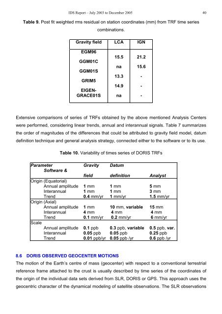
Table 9. Post fit weighted rms residual on station coordinates (mm) from TRF time series<br />
combinations.<br />
Gravity field LCA IGN<br />
EGM96<br />
GGM01C<br />
GGM01S<br />
GRIM5<br />
EIGEN-<br />
GRACE01S<br />
Extensive comparisons of series of TRFs obtained by the above mentioned Analysis Centers<br />
were performed, considering linear trends, annual and interannual signals. Table 7 summarizes<br />
the order of magnitudes of the differences that could be attributed to gravity field model, datum<br />
definition technique and general analysis strategy, connected either to the software or to its use.<br />
15.5<br />
na<br />
13.3<br />
14.9<br />
na<br />
21.2<br />
15.6<br />
Table 10. Variability of times series of <strong>DORIS</strong> TRFs<br />
Parameter Gravity Datum<br />
Software &<br />
field definition Analyst<br />
Origin (Equatorial)<br />
Annual amplitude 1 mm 1 mm 5 mm<br />
Interannual 1 mm 1 mm 3 mm<br />
Trend 0.4 mm/yr 1 mm/yr 1.5 mm/yr<br />
Origin (Axial)<br />
Annual amplitude 1 mm 10 mm, variable 15 mm<br />
Interannual 4 mm 4 mm 4 mm<br />
Trend 0.1 mm/yr 0.2 mm/yr 6 mm/yr<br />
Scale<br />
Annual amplitude 0.1 ppb 0.3 ppb, variable 0.5 ppb, var.<br />
Interannual 0.05 ppb 0.05 ppb 0.25 ppb<br />
Trend 0.01 ppb/yr 0.05 ppb /yr 0.6 ppb /yr<br />
8.6 <strong>DORIS</strong> OBSERVED GEOCENTER MOTIONS<br />
<strong>The</strong> motion of the Earth’s centre of mass (geocenter) with respect to a conventional terrestrial<br />
reference frame attached to the crust is usually described by time series of the coordinates of<br />
the origin of the individual data sets derived from SLR, <strong>DORIS</strong> or GPS. This approach uses the<br />
geocentric character of the dynamical modeling of satellite observations. <strong>The</strong> SLR observations<br />
-<br />
-<br />
-