CEAC-2022-06-June

You also want an ePaper? Increase the reach of your titles
YUMPU automatically turns print PDFs into web optimized ePapers that Google loves.
News<br />
To Stop Baton Rouge Floods, They’re<br />
Carving a 12-Mile River By David J. Mitchell, The Advocate<br />
ZACHARY, La. (AP) — You can’t quite see it yet from Plank<br />
Road or La. 19 near Zachary, but work crews are building a<br />
man-made river from scratch.<br />
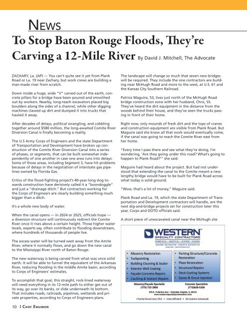
Down inside a huge, wide “V” carved out of the earth, concrete<br />
pillars for a bridge have been poured and smoothed<br />
out by workers. Nearby, long-reach excavators placed big<br />
boulders along the sides of a channel, while other digging<br />
machines clawed up dirt and dumped it into trucks that<br />
hauled it away.<br />
After decades of delays, political wrangling, and cobbling<br />
together around $580 million, the long-awaited Comite River<br />
Diversion Canal is finally becoming a reality.<br />
The U.S Army Corps of Engineers and the state Department<br />
of Transportation and Development have broken up construction<br />
of the Comite River Diversion Canal into a series<br />
of phases, or segments, that can be built somewhat independently<br />
of one another in case one area runs into delays.<br />
Some of those areas, including Segment 3, have hit problems<br />
because of delays in the negotiation of interstate gas pipelines<br />
owned by Florida Gas.<br />
Critics of the flood-fighting project’s 40-year-long slog towards<br />
construction have derisively called it a “boondoggle”<br />
and just a “drainage ditch.” But contractors working for<br />
the Corps of Engineers are clearly building something much<br />
bigger than a ditch.<br />
It’s a whole new body of water.<br />
When the canal opens — in 2024 or 2025, officials hope —<br />
a diversion structure will continuously redirect the Comite<br />
River once it rises above a certain height. Those higher water<br />
levels, experts say, often contribute to flooding downstream,<br />
where hundreds of thousands of people live.<br />
The landscape will change so much that seven new bridges<br />
will be required. They include the one contractors are building<br />
near McHugh Road and more to the west, at U.S. 61 and<br />
the Kansas City Southern Railroad.<br />
Patrice Maguire, 53, lives just north of the McHugh Road<br />
bridge construction zone with her husband, Chris, 55.<br />
They’ve heard the dirt equipment in the distance from the<br />
woods behind their house, and they’ve seen the trucks passing<br />
in front of their home.<br />
Right now, only mounds of fresh dirt and the tops of cranes<br />
and construction equipment are visible from Plank Road. But<br />
Maguire said she knew all that work would eventually come,<br />
if the canal was going to reach the Comite River east from<br />
her home.<br />
“Every time I pass there and see what they’re doing, I’m<br />
wondering, ‘Are they going under this road? What’s going to<br />
happen to Plank Road?’” she said.<br />
Maguire had heard about the project. But had not understood<br />
that extending the canal to the Comite meant a new<br />
lengthy bridge would have to be built for Plank Road across<br />
what today is solid ground.<br />
“Wow, that’s a lot of money,” Maguire said.<br />
Plank Road and La. 19, which the state Department of Transportation<br />
and Development contractors will handle, are the<br />
next dig-and-bridge projects set for construction later this<br />
year, Corps and DOTD officials said.<br />
A short piece of unexcavated canal near the McHugh site<br />
The excess water will be turned west away from the Amite<br />
River, where it normally flows, and go down the new canal<br />
to the Mississippi River north of Baton Rouge.<br />
The new waterway is being carved from what was once solid<br />
earth. It will be able to funnel the equivalent of the Arkansas<br />
River, reducing flooding in the middle Amite basin, according<br />
to Corps of Engineers’ estimates.<br />
To accomplish that goal, this straight, rock-lined waterway<br />
will need everything in its 12-mile path to either get out of<br />
its way, go over its banks, or slide underneath its bottom.<br />
That includes roads, railroads, pipelines, wetlands and private<br />
properties, according to Corps of Engineers plans.<br />
10<br />
| Chief Engineer