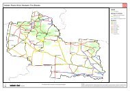
Bannockburn Town Centre Investment Strategy - Golden Plains Shire
Bannockburn Town Centre Investment Strategy - Golden Plains Shire
Bannockburn Town Centre Investment Strategy - Golden Plains Shire

Create successful ePaper yourself
Turn your PDF publications into a flip-book with our unique Google optimized e-Paper software.
<strong>Bannockburn</strong> <strong>Town</strong> <strong>Centre</strong> <strong>Investment</strong> <strong>Strategy</strong> <strong>Golden</strong> <strong>Plains</strong> <strong>Shire</strong> Council<br />
predominantly single storey. The subdivision pattern in the core business area of <strong>Bannockburn</strong> is<br />
generally uniform, with most lots being of regular, rectangular shape and originally laid out as<br />
residential lots. Recent subdivisions have increased the density of housing in the town centre precinct<br />
with the development of units and dual occupancies.<br />
The <strong>Town</strong> <strong>Centre</strong> is bordered to the north by the Railway line, and to the east, west and south by<br />
predominantly residential development. Other notable uses in the area include the <strong>Bannockburn</strong><br />
Primary School on the south west corner of High Street and Milton Street, <strong>Bannockburn</strong> Sports<br />
Stadium immediately to its south, and the <strong>Bannockburn</strong> Community <strong>Centre</strong> on the eastern side of High<br />
Street south of Milton Street, opposite the school. The <strong>Bannockburn</strong> Recreation Reserve is located two<br />
blocks to the east of High Street in Moore Street.<br />
Residential development has radiated outwards from the central axis of High Street and the<br />
commercial precinct. Low to conventional density housing is focused around the main township area,<br />
along Byron, Moore, Burns and Victor Streets. The residential areas of the town are predominantly<br />
single storey. Rural residential development is located predominantly to the north and east of the<br />
township. Further residential development is planned for areas south of Burnside Road, which is<br />
suitably zoned to accommodate such development. Land north of Milton Street, west of the township<br />
and running though to McPhillips Road, has also been rezoned for residential purposes (Residential 1<br />
Zone).<br />
2.3 Demographics<br />
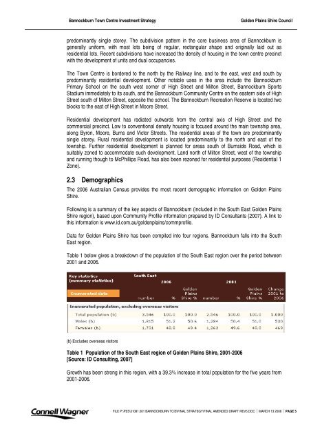
The 2006 Australian Census provides the most recent demographic information on <strong>Golden</strong> <strong>Plains</strong><br />
<strong>Shire</strong>.<br />
Following is a summary of the key aspects of <strong>Bannockburn</strong> (included in the South East <strong>Golden</strong> <strong>Plains</strong><br />
<strong>Shire</strong> region), based upon Community Profile information prepared by ID Consultants (2007). A link to<br />
this information is www.id.com.au/goldenplains/commprofile.<br />
Data for <strong>Golden</strong> <strong>Plains</strong> <strong>Shire</strong> has been compiled into four regions. <strong>Bannockburn</strong> falls into the South<br />
East region.<br />
Table 1 below gives a breakdown of the population of the South East region over the period between<br />
2001 and 2006.<br />
(b) Excludes overseas visitors<br />
Table 1 Population of the South East region of <strong>Golden</strong> <strong>Plains</strong> <strong>Shire</strong>, 2001-2006<br />
[Source: ID Consulting, 2007]<br />
Growth has been strong in this region, with a 39.3% increase in total population for the five years from<br />
2001-2006.<br />
FILE P:\PES\31081.001 BANNOCKBURN TCIS\FINAL STRATEGY\FINAL AMENDED DRAFT REV5.DOC ⏐ MARCH 13 2008 ⏐ PAGE 5