Africa Surveyors November-December issue 2023
Africa Surveyors is Africa’s premier source of Surveying, Mapping and Geospatial news and an envoy of surveying products/service for the Construction, Maritime, Onshore & Offshore energy and exploration, Engineering, Oil and Gas, Agricultural and Mining sectors on new solution based trends and technology for the African market.
Africa Surveyors is Africa’s premier source of Surveying, Mapping and Geospatial news and an envoy of surveying products/service for the Construction, Maritime, Onshore & Offshore energy and exploration, Engineering, Oil and Gas, Agricultural and Mining sectors on new solution based trends and technology for the African market.

Create successful ePaper yourself
Turn your PDF publications into a flip-book with our unique Google optimized e-Paper software.
INTERNATIONAL<br />
LiDAR developer and manufacturer<br />
YellowScan and drone manufacturer<br />
DeltaQuad are joining forces once again.<br />
The outcome – more quality 3D mapping<br />
data than ever. The YellowScan Surveyor<br />
Ultra LiDAR system with an embedded<br />
camera is now integrated into DeltaQuad Evo,<br />
bringing 1200 ha of dense point clouds for<br />
professionals worldwide.<br />
Longer quality flight times<br />
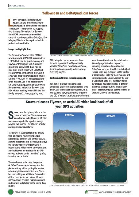
Yellowscan and DeltaQuad join forces<br />
The YellowScan Surveyor Ultra OEM is a<br />
new lightweight 360° LiDAR system with a<br />
120° field of view for quality mapping and<br />
surveying. Standing out with high point<br />
density and light weight, it can now be<br />
used to its fullest extent with DeltaQuad<br />
Evo Unmanned Aerial Vehicle (UAV). Evo is<br />
a new-age fixed-wing Vertical Take-off and<br />
Landing (VTOL) UAV for multipurpose longrange<br />
missions. Due to its modularity, Evo<br />
can carry multiple payloads simultaneously,<br />
like the newest YellowScan Surveyor Ultra<br />
OEM with an auxiliary battery. This lets the<br />
Evo fly for up to 225 min, capturing up to<br />
Record 1200 ha of colorized LiDAR coverage Image: DELTAQUAD<br />
100 data points per square meter. Since<br />
the data is processed swiftly and easily<br />
with the YellowScan CloudStation software,<br />
the integration is perfectly suited for large<br />
surveying projects.<br />
Continuous attention to mapping experts<br />
Just earlier this year, both companies<br />
announced Evo becoming the first fixed-wing<br />
eVTOL UAV to integrate YellowScan LiDAR &<br />
RGB systems. Now, Tristan Allouis, cofounder<br />
and CEO of YellowScan, shares the excitement<br />
about the continuation of the collaboration:<br />
“Gradual progress is what empowers<br />
trembling innovations. Integrating the<br />
YellowScan Surveyor Ultra OEM in DeltaQuad<br />
Evo is a small step but opens up the window<br />
of opportunities wider for many mapping and<br />
surveying experts.” Douwe Zeeman, the CEO<br />
of DeltaQuad, adds: “It is a pleasure to see<br />
our products help professionals in different<br />
industries and regions. Now, enabled to fly<br />
longer distances, they can use the benefits of<br />
colorized LiDAR to the maximum.”<br />
Strava releases Flyover, an aerial 3D video look back of all<br />
your GPS activities<br />
Strava, the subscription platform at the<br />
center of connected fitness, announced<br />
a new feature today, Flyover, a 3D video<br />
map rendering with the signature orange<br />
polyline that recreates the athlete’s activities<br />
and inspires new adventures.<br />
The Flyover is a video recap of the activity<br />
from a bird’s eye view, offering Strava<br />
subscribers a different take on their activity.<br />
Starting by zooming into the route, it displays<br />
the signature Strava orange polyline in<br />
motion as the athlete moves throughout the<br />
activity. Flyovers are available for all GPSenabled<br />
activities on the subscriber’s profile,<br />
including past activities.<br />
The new feature is the latest integration<br />
of FATMAP’s mapping technology into the<br />
platform. Along with acquiring the outdoor<br />
adventure platform earlier this year, Strava<br />
has been rolling out additional features for<br />
athletes to enjoy such as winter 3D maps,<br />
maps and route creation, custom waypoints,<br />
route details and photos via the online Route<br />
Builder.<br />
The platform offers a 3D video map rendering of the athlete’s adventure. Images: STRAVA<br />
6 <strong>November</strong>-<strong>December</strong> <strong>issue</strong> l <strong>2023</strong> www.africasurveyorsonline.com