Africa Surveyors September-October issue 2023
Africa Surveyors is Africa’s premier source of Surveying, Mapping and Geospatial news and an envoy of surveying products/service for the Construction, Maritime, Onshore & Offshore energy and exploration, Engineering, Oil and Gas, Agricultural and Mining sectors on new solution based trends and technology for the African market.
Africa Surveyors is Africa’s premier source of Surveying, Mapping and Geospatial news and an envoy of surveying products/service for the Construction, Maritime, Onshore & Offshore energy and exploration, Engineering, Oil and Gas, Agricultural and Mining sectors on new solution based trends and technology for the African market.
- TAGS
- marinesurveys
- geospatialmapping
- precisionagriculture
- 3dfusion
- climatechange
- africa
- africasurveyors
- dronesinafrica
- norbitsubsea
- norbitmultibeam
- seismicsurveys
- dronesurveying
- seafloormapping
- offshoresurveys
- quantitysurveyors
- underwaterrobotics
- subseasolutions
- hydographicsurvey
- multibeamandlidar
- gdansk

You also want an ePaper? Increase the reach of your titles
YUMPU automatically turns print PDFs into web optimized ePapers that Google loves.
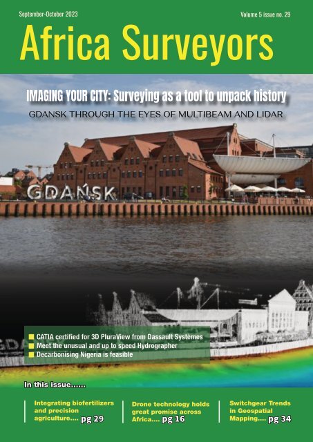
<strong>September</strong>-<strong>October</strong> <strong>2023</strong> Volume 5 <strong>issue</strong> no. 29<br />
<strong>Africa</strong> <strong>Surveyors</strong><br />
IMAGING YOUR CITY: Surveying as a tool to unpack history<br />
GDANSK THROUGH THE EYES OF MULTIBEAM AND LIDAR<br />
CATIA certified for 3D PluraView from Dassault Systèmes<br />
Meet the unusual and up to speed Hydrographer<br />
Decarbonising Nigeria is feasible<br />
In this <strong>issue</strong>......<br />
Integrating biofertilizers<br />
and precision<br />
agriculture....<br />
www.africasurveyorsonline.com<br />
Drone technology holds<br />
great promise across<br />
<strong>Africa</strong>....<br />
Switchgear Trends<br />
in Geospatial<br />
Mapping....<br />
pg 29 pg 16 pg 34<br />
<strong>September</strong>-<strong>October</strong> <strong>issue</strong> l <strong>2023</strong> 1
AVAILABLE NOW<br />
Survey | Spill Response | Search-and-Rescue | Fire | Security | Offshore Wind | Aquaculture<br />
Sea Machines’ innovation and advanced technology gives vessel owners an operational advantage. Contact us to<br />
schedule a live demonstration and learn how Sea Machines can solve your most persistent challenges on the water.<br />
SEA MACHINES<br />
Request a live demo at<br />
sea-machines.com/contact
Contents<br />
CONTENTS<br />
Current Issue<br />
In this <strong>issue</strong> we look at<br />
Surveying as a tool to unpack<br />
history - Gdansk through the<br />
eyes of Multibeam and Lidar<br />
and many more....enjoy the<br />
<strong>issue</strong>!<br />
30 32<br />
REGULARS<br />
News Briefs 4<br />
Events 8<br />
18<br />
Innovation 10<br />
Opinion 14<br />
Project review 36<br />
Director<br />
Augustine M. Rang'ondi<br />
Senior Editor &<br />
Marketing Lead<br />
Dorcas Kang’ereha<br />
COVER STORY<br />
IMAGING YOUR CITY: Surveying as a tool to unpack<br />
history<br />
22<br />
Writers<br />
Harriet Mkhaye<br />
Irene Joseph<br />
Innocent Momanyi<br />
Sales Executives<br />
East <strong>Africa</strong><br />
Jimmy Mudasia<br />
Lydia Kamonya<br />
Caiser Momanyi<br />
Vincent Murono<br />
Sheila Ing’ayitsa<br />
South <strong>Africa</strong><br />
Paul Nyakeri<br />
Sean Masangwanyi<br />
Lisa Brown<br />
Thembisa Ndlovu<br />
Features<br />
Anniversary: 30 years of passion, and still passionate<br />
about hydrography!<br />
Drones in <strong>Africa</strong>: Drone technology holds great promise<br />
across <strong>Africa</strong><br />
Geospatial: Switchgear Trends in Geospatial Mapping<br />
Energy: Decarbonising Nigeria is feasible with current power<br />
technologies<br />
Precision Agriculture: Integrating biofertilizers and<br />
precision agriculture<br />
12<br />
Nigeria<br />
Emelda Njomboro<br />
Uche Maxwel<br />
Designed and<br />
Published by:<br />
Josem Trust House,<br />
3rd Floor, Upper Hill.<br />
P.O. Box 52248-00100,<br />
Nairobi, Kenya.<br />
ADVERTISER'S INDEX<br />
Sea Machines..........................................................................IFC<br />
Caroni.......................................................................................IBC<br />
Navvis.......................................................................................OBC<br />
Norbit......................................................................................pg 15<br />
Amaza Surveys......................................................................pg 20<br />
<strong>Africa</strong> <strong>Surveyors</strong>....................................................................pg 20<br />
Alwarqa Survey Engineering...............................................pg 23<br />
Altavec.....................................................................................pg 25<br />
Euclideon.................................................................................pg 35<br />
Imagenex.................................................................................pg 36<br />
Forssea Robotics....................................................................pg 37<br />
MacArtney...............................................................................pg 38<br />
34<br />
Contact us:<br />
Tel: +254 113 194 740<br />
Emaii: info@africasurveyorsonline.com<br />
Web: https://africasurveyorsonline.com<br />
The Editor accepts letter and manuscripts for publication from readers all over the world. Include your name and address as a sign of good faith although you may<br />
request your name to be withheld from publication. We can reserve the right to edit any material submitted. Send your letters to: info@africasurveyorsonline.com<br />
Disclaimer:<br />
Nailex <strong>Africa</strong> Publishing makes every effort to ensure the accuracy of the contents of its publications, but no warranty is made to such accuracy and<br />
no responsibility will be borne by the publisher for the consequences of actions based on information so published. Further, opinions expressed on<br />
interviews are not necessarily shared by Nailex <strong>Africa</strong> Publisher.<br />
www.africasurveyorsonline.com<br />
<strong>September</strong>-<strong>October</strong> <strong>issue</strong> l <strong>2023</strong> 3
NEWS BRIEFS<br />
PGS Awarded 4D Survey Contract Offshore West <strong>Africa</strong><br />
PGS Awarded 4D Survey Contract Offshore West<br />
<strong>Africa</strong>|Image: Courtesy<br />
PGS, a Norwegian marine seismic<br />
survey services firm is awarded a 4D<br />
acquisition contract offshore West<br />
<strong>Africa</strong>. Mobilization is scheduled for Q4<br />
and the contract has a total duration of<br />
approximately 60 days.<br />
“We experience continued high<br />
activity in our core West <strong>Africa</strong>n<br />
markets and are very pleased<br />
with this contract award. Our<br />
Ramform acquisition platform in<br />
combination with multi-sensor<br />
GeoStreamer technology will<br />
provide the client with highquality<br />
4D seismic data,” says<br />
President & CEO in PGS, Rune<br />
Olav Pedersen.<br />
PGS announces contract awards and<br />
MultiClient projects as stock exchange<br />
releases if the contract has a value of<br />
$10 million or more, MultiClient projects<br />
with a duration of 2 months or more and<br />
strategically important contracts.<br />
N-Sea contributes to the Nigeria-Morocco gas pipeline<br />
development with survey operations<br />
Gorée Offshore Engineering<br />
signs OA with Woodside<br />
Energy (Senegal) for Subsea<br />
Integrity Management<br />
Engineering Services<br />
Gorée Offshore<br />
Engineering<br />
signs OA with<br />
Woodside Energy<br />
(Senegal) for<br />
Subsea Integrity<br />
Management<br />
Engineering<br />
Services |Image:<br />
Gorée Offshore<br />
Engineering<br />
Gorée Offshore Engineering Senegal<br />
(Gorée) – in Consortium with Genesis,<br />
a wholly-owned Technip Energies<br />
company – has signed a multi-year Outline<br />
Agreement (OA) with Woodside Energy<br />
(Senegal) B.V.<br />
The Consortium will provide Asset Integrity<br />
Management Engineering Services to the<br />
Sangomar Field’s first phase, located offshore<br />
Senegal and operated by Woodside.<br />
N-Sea contributes to the Nigeria-Morocco gas pipeline<br />
development with survey operations| image: courtesy<br />
N-Sea, a Netherlands-based underwater<br />
solutions provider, is contributing<br />
to the development of the Nigeria-<br />
Morocco Gas Pipeline (NMGP) project<br />
through survey operations. The company has<br />
collaborated closely with ship owner Rederij<br />
Groe to transform the seismic support vessel,<br />
7-Waves, into a research vessel equipped<br />
with advanced equipment for this project.<br />
According to N-Sea, the project is being<br />
conducted with a reduced crew on board the<br />
vessel, with all data being transferred to the<br />
N-Sea data center onshore.<br />
Daily meetings are held with the client’s<br />
representative, the FEED engineer, the client,<br />
and the company’s data processors to assess<br />
data quality and route alignment, N-Sea said<br />
in a statement.<br />
“N-Sea has expanded its operational area<br />
to West <strong>Africa</strong> by commencing survey<br />
operations to support the prestigious<br />
Nigeria-Morocco Gas Pipeline project,”<br />
emphasized N-Sea.<br />
N-Sea emphasized the significance of<br />
the project, noting that the pipeline is<br />
set to connect multiple countries and<br />
provide intermittent onshore returns for<br />
compression as a base case. The Nigeria-<br />
Morocco gas pipeline is an ambitious<br />
project aimed at helping <strong>Africa</strong> become<br />
self-sufficient in terms of energy needs and<br />
benefiting over 400 million people in West<br />
<strong>Africa</strong>. It will connect 11 countries in the<br />
region to Nigerian gas sources.<br />
Morocco is set to host 1,672 kilometers<br />
of the 5,600-kilometer-long pipeline.<br />
The project has garnered support from<br />
numerous countries, with agreements in<br />
place to ensure its implementation. In<br />
June, Morocco’s Hydrocarbon and Mines<br />
Office ONHYM, along with the Nigerian<br />
National Petroleum Corporation (NNPC),<br />
signed Memoranda of Understanding with<br />
petroleum operators in various countries,<br />
including Guinea, Liberia, Benin, and Côte<br />
d’Ivoire.<br />
This international Consortium will be pivotal<br />
in delivering a successfully integrated<br />
Integrity Management offering for Woodside<br />
while delivering key local content milestones<br />
in developing and supporting Senegalese<br />
engineers through knowledge sharing, onthe-job<br />
training, mentoring, and interactive<br />
learning.<br />
Gaspard Mendy, MD at Gorée Offshore<br />
Engineering reacted: “This really is a big<br />
one for our team of local engineers. The<br />
Woodside Sangomar field consists of some of<br />
the most cutting-edge subsea technology in<br />
the world and we are excited and humbled<br />
to be entrusted with its upkeep. We relish the<br />
opportunity to work with Technip Energies<br />
and Genesis, who have an unrivalled trackrecord<br />
and expertise in subsea engineering.<br />
We look forward also, to working closely with<br />
the Woodside team and to delivering for<br />
them here in Senegal”.<br />
Gorée Offshore Engineering Senegal,<br />
founded in November 2019, is a leading<br />
Senegalese oil and gas engineering services<br />
company delivering engineering design,<br />
asset integrity and repair and maintenance<br />
solutions to Tier 1 and Tier 2 blue-chip<br />
energy companies operating onshore and<br />
offshore Senegal and Mauritania.<br />
4 <strong>September</strong>-<strong>October</strong> <strong>issue</strong> l <strong>2023</strong> www.africasurveyorsonline.com
NEWS BRIEFS<br />
TotalEnergies gets<br />
greenlight to drill offshore<br />
South <strong>Africa</strong><br />
Image: courtesy<br />
TotalEnergies has secured green light<br />
from the environment ministry of<br />
South <strong>Africa</strong> to drill for oil and gas<br />
offshore, reported Reuters.<br />
The approval comes after the government<br />
authority rejected appeals by lobby groups<br />
and individuals challenging further<br />
exploration for offshore oil and gas.<br />
The most recent in a string of appeals was<br />
the effort to stop TotalEnergies from drilling<br />
in Blocks 5/6/7 offshore Cape Town.<br />
The environmental authorisation given<br />
to the French oil and gas company by the<br />
Department of Mineral Resources and Energy<br />
in April was challenged on a number of<br />
grounds, including marine noise, oil spills,<br />
climate change, and inadequate public<br />
consultation.<br />
Environmental activist groups aimed to<br />
persuade Environment Minister Barbara<br />
Creecy to revoke the authorisation.<br />
However, Creecy, as the appellate authority,<br />
dismissed their concerns, the news agency<br />
reported citing the ruling.<br />
“I am therefore satisfied that the impacts<br />
of noise and light have been adequately<br />
assessed and mitigated to ensure low impacts<br />
on the receiving environment. As such this<br />
ground of appeal is dismissed,” Creecy was<br />
quoted as saying.<br />
Climate Justice Charter Movement, one of the<br />
appellants, described Creecy’s judgement as<br />
“disappointing but unsurprising.”<br />
“The decision by the minister will be<br />
challenged, it is irrational and ignores climate<br />
science,” it said in a statement.<br />
Trimble commits to Nigeria through digital technologies<br />
Trimble, an industrial technology<br />
company, has disclosed plans to<br />
unlock opportunities in areas of<br />
agriculture, surveying, architecture, mining,<br />
construction, among others through the<br />
deployment of digital technology in Nigeria.<br />
According to Albert Momo, Trimble’s vice<br />
president and Executive Director in charge<br />
of emerging markets and funded projects,<br />
the conference will feature plenary, breakout<br />
sessions and live demonstrations by Trimble<br />
businesses in the geospatial, advanced<br />
positioning, land administration, agriculture,<br />
construction, and the utilities sectors.<br />
“This event will unlock opportunities<br />
in areas including energy, mining, and<br />
Rwanda launches Institute of Quantity <strong>Surveyors</strong><br />
On July 14th <strong>2023</strong>, the Ministry of<br />
Infrastructure successfully launched<br />
the Institute of Quantity <strong>Surveyors</strong><br />
in Rwanda (RIQS) which will enable<br />
the government to properly implement<br />
construction projects and account for value<br />
for money.<br />
The newly launched institution becomes<br />
the youngest institution in the East<br />
<strong>Africa</strong>n region where other member states,<br />
particularly Kenya, Uganda and Tanzania who<br />
have already established institutions for over<br />
40 years.<br />
The establishment of the institution was also<br />
preceded by the first RIQS general assembly<br />
in Rwanda in which the council members<br />
were elected to be led by QS Charles<br />
Lugira as the Chairman, and QS Frederick<br />
Nyaminani as the vice-Chairman.<br />
Dr. Ernest Nsabimana, the Minister of<br />
Infrastructure, said that quantity surveyors<br />
play a crucial role in shaping the landscape<br />
of Rwanda’s growing construction sector<br />
and can never be underestimated especially<br />
when it comes to value for money.<br />
Quantity <strong>Surveyors</strong> are the financial<br />
custodians and the master strategists of<br />
contract management who ensure the<br />
successful delivery of construction projects<br />
while maintaining cost-effectiveness and<br />
geospatial as well as provide potential users<br />
with the requisite knowledge of Trimble<br />
solutions, as the company seeks to expand in<br />
the West <strong>Africa</strong>n market. Trimble remains a<br />
dedicated industrial technology company that<br />
transforms the world in enabling customers<br />
to deliver prominent solutions with the use<br />
of core technologies in positioning, modeling,<br />
connectivity, and data analytics to connect<br />
the digital and physical worlds to improve<br />
productivity, quality, safety, transparency, and<br />
sustainability,” said Momo.<br />
“Agriculture and Construction alone – two<br />
areas Trimble solutions support contributed<br />
over a quarter to the nominal GDP of Nigeria<br />
on <strong>2023</strong> Q1 and remain sectors that the<br />
Nigerian government is very keen to grow,”<br />
he adds.<br />
Image: courtesy<br />
quality standards,” Dr. Nsabimana said.<br />
“Your expertise is vital in safeguarding our<br />
infrastructure investments and driving the<br />
sustainable development agenda across<br />
Rwanda and the continent as a whole,” he<br />
added.<br />
Quantity Surveying (QS) is a professional<br />
career of experts who estimate and control<br />
costs for large construction projects and by<br />
legalizing their activities in Rwanda, the<br />
institute will remove the chaos in Rwanda’s<br />
growing construction sector where other<br />
professionals in the construction sector<br />
especially engineers, and architects have<br />
been assuming the QS jobs.<br />
The establishment of the Rwanda Institute<br />
of Quantity <strong>Surveyors</strong> comes at an opportune<br />
moment when the construction industry is<br />
experiencing rapid growth and development.<br />
With ambitious infrastructure projects and<br />
burgeoning urbanization, the demand for<br />
quantity surveyors has never been greater.<br />
www.africasurveyorsonline.com<br />
<strong>September</strong>-<strong>October</strong> <strong>issue</strong> l <strong>2023</strong> 5
INTERNATIONAL<br />
RWE appoints Fugro<br />
to start geophysical<br />
survey for Denmark’s<br />
largest offshore wind<br />
farm, Thor<br />
Image: FUGRO<br />
RWE has appointed Fugro to complete<br />
a geophysical survey off the Danish<br />
west coast. Up to three survey vessels<br />
will be deployed to carry out a detailed<br />
pre-construction survey including a search<br />
for unexploded ordnance (UXO) up to<br />
approximately 34 kilometres off the coast of<br />
Thorsminde. The data acquired is important<br />
and will define the cable routes and exact<br />
turbine locations for RWE’s Thor offshore<br />
wind farm.<br />
The awarded contract builds upon Fugro's<br />
prior involvement in the project, which<br />
included a comprehensive geotechnical site<br />
investigation conducted in 2022.<br />
Günther Fenle, Project Director Thor Offshore<br />
Wind Farm, RWE Offshore Wind said: “We are<br />
looking forward to using the data collected by<br />
Fugro to finalise the layout of the wind farm<br />
and to determine the routes for the interarray<br />
and export cables. This is an important<br />
step towards the start of the construction<br />
works at sea in 2025.”<br />
Marc Kebbel, Fugro’s Service Line Director<br />
of Hydrography and Cable Route Surveys<br />
said: “We are using a wide range of survey<br />
techniques, comprising offshore and<br />
nearshore standard geophysical and UXO<br />
survey techniques, a seismic land refraction<br />
survey, and last but not least, Fugro’s rapid<br />
airborne multibeam mapping system<br />
(RAMMS) for comprehensive mapping of the<br />
shallow area and beach in the transition<br />
zone.”<br />
FarSounder joins Seabed 2030 in Mapping the<br />
World's Oceans<br />
FarSounder is partnering with The<br />
Nippon Foundation-GEBCO Seabed<br />
2030 Project to work together to<br />
advance the collective understanding of the<br />
ocean floor in pursuit of the complete map<br />
of the entire seabed.<br />
This partnership coincides with FarSounder's<br />
recent Small Business Innovation Research<br />
(SBIR) Phase I grant awarded by the National<br />
Oceanic and Atmospheric Administration<br />
(NOAA). This award is providing funding<br />
for the research and development of a<br />
new project that will develop a cloudbased<br />
service to shareFarSounder/NSSL<br />
Global survey data collected by FarSounder<br />
customers.<br />
The project – Enabling Expanded<br />
Crowdsourced Bathymetry Contributions<br />
With High-Quality Metadata via<br />
Commercially Sustainable Incentives to<br />
Contributors – will allow for data sharing<br />
with others across the FarSounder customer<br />
fleet and with Seabed 2030 via the<br />
International Hydrographic Organization's<br />
(IHO) Data Centre for Digital Bathymetry<br />
(DCDB), which archives over 30 terabytes of<br />
Trimble (NASDAQ: TRMB) and the<br />
Trimble Foundation Fund have<br />
partnered with The HALO Trust, the<br />
world’s largest landmine-clearing non-profit<br />
organization, to help expand its demining<br />
operations across Ukraine. The Foundation<br />
Fund directed grant focuses on strengthening<br />
the HALO Trust’s capacity to locate and<br />
remove landmines, unexploded ordnance, and<br />
other explosive hazards from civilian areas to<br />
create safer communities.<br />
The Russian invasion of Ukraine has resulted<br />
in the contamination of massive swaths of<br />
the country with landmines, unexploded<br />
ordnance, and improvised explosive devices.<br />
These explosive hazards block access to<br />
farmland, impede reconstruction efforts,<br />
prevent displaced persons from returning<br />
to their homes, and continue to hinder the<br />
oceanic depth soundings and serves as the<br />
long-term archive for Seabed 2030.<br />
Seabed 2030 is a collaborative project<br />
between The Nippon Foundation and the<br />
General Bathymetric Chart of the Oceans<br />
(GEBCO), which seeks to inspire the complete<br />
mapping of the world's ocean by 2030, and to<br />
compile all the data into the freely available<br />
GEBCO Ocean Map. The Project is formally<br />
endorsed as a Decade Action of the UN<br />
Ocean Decade. GEBCO is a joint programme<br />
of the IHO and the Intergovernmental<br />
Oceanographic Commission (IOC), and is the<br />
only organisation with a mandate to map the<br />
entire ocean floor.<br />
"Our commitment to contributing highresolution<br />
data to the IHO's DCDB aligns<br />
seamlessly with Seabed 2030's mission of<br />
achieving a complete map of the entire ocean<br />
floor," commented FarSounder CEO Matthew<br />
Zimmerman. "By streamlining the transfer of<br />
data from customers to the DCDB we hope<br />
to encourage broader participation, inviting<br />
more individuals to actively contribute to<br />
bridging the gaps in our understanding of the<br />
ocean."<br />
Trimble Partners with HALO Trust for Landmine<br />
Clearance in Ukraine<br />
Bucha, Kyiv Oblast, Ukraine. Staff from the<br />
landmine clearance charity The HALO Trust<br />
clearing ground of unexploded ordnance<br />
(UXO) such as artillery fuses at Bucha, just<br />
outside Kyiv Oblast, Ukraine.<br />
© Chris Strickland / HALO<br />
safety of Ukrainian civilians. The Government<br />
of Ukraine estimates that 174,000 square<br />
kilometers of its land may be contaminated—<br />
this is roughly the size of Virginia, Maryland,<br />
and Connecticut combined.<br />
6 <strong>September</strong>-<strong>October</strong> <strong>issue</strong> l <strong>2023</strong> www.africasurveyorsonline.com
INTERNATIONAL<br />
Microdrones to sell designed and made in America drone surveying<br />
equipment starting in 2024<br />
Following the product launch of the<br />
EasyOne mid-year, Microdrones will<br />
start manufacturing this system in<br />
its Huntsville, AL site in 2024. In order to<br />
better support the ramp up of manufacturing<br />
activities as well as current and future U.S.<br />
customer needs, Microdrones will further<br />
transfer key R&D activities to Huntsville.<br />
According to Vivien Hériard Dubreuil, CEO of<br />
mdGroup (parent company of Microdrones),<br />
“Strengthening our existing operations in<br />
the U.S. is a natural move for us. Our group<br />
has a longstanding presence in Huntsville,<br />
and we have been supporting Microdrones<br />
U.S. customers from Huntsville for the past<br />
18 months. Now, in light of the energy of<br />
the drone surveying market in the U.S. and a<br />
strong reception by U.S. customers, it makes<br />
sense to bring these functions closer to those<br />
customers. We were already selling NDAA-<br />
Image: Microdrones<br />
compliant versions of our products; now our<br />
products will be designed and made in the<br />
U.S.”<br />
Vincent Legrand, VP of Sales added, “In<br />
everything we do, our utmost priority is to<br />
meet and fully address our customer needs.<br />
The EasyOne is born from customer demand<br />
for a compact drone LiDAR surveying<br />
system that can be easily deployed while<br />
quickly delivering high quality results. With<br />
a uniquely compact form factor, perfectly<br />
integrated LiDAR, our LP360 point cloud<br />
processing software as well as NDAA<br />
compliant options made in the United States,<br />
customers now have exactly what they have<br />
been asking for.”<br />
Reach Subsea has now signed survey contract with major<br />
Scottish energy firm SSEN Transmission<br />
With reference to the release dated 17 August <strong>2023</strong><br />
regarding notice of a contract award, Reach Subsea, the<br />
trusted data and subsea service provider for oceanbased<br />
industries, announces the signing of the final contract and<br />
further details on the assignment.<br />
The contract constitutes a detailed corridor survey for the Spittal<br />
to Peterhead HVDC power cable. The data will be used for<br />
detailed engineering and environmental assessment of potential<br />
cable routes with the survey corridor. The contract counterparty<br />
is SSEN Transmission, the transmission network operator<br />
responsible for the high voltage electricity transmission network<br />
in the north of Scotland. SSEN Transmission is carrying out a<br />
significant upgrade of the electricity transmission network in the<br />
region, launching a ‘Pathway to 2030’ programme of projects to<br />
facilitate the increase in renewable energy generation across the<br />
north of Scotland and deliver a network for net zero emissions.<br />
The work is scheduled for execution in the fourth quarter of <strong>2023</strong>,<br />
with a duration of approximately 75 vessel days. The ROV survey<br />
vessel Viking Reach with its permanently mobilized high-speed<br />
Surveyor Interceptor ROV will be utilized.<br />
"We have ramped up our capacity significantly over the last<br />
couple of years to serve a rapidly growing market with a<br />
www.africasurveyorsonline.com<br />
Image: Reach Subsea<br />
broadened service offering. Our international presence is expanding<br />
fast with Aberdeen as a core location, and we are extremely pleased<br />
to be welcoming SSEN Transmission as a new significant client. The<br />
contract win is a strong endorsement of Reach Subsea’s attractivity for<br />
large clients and capabilities in solving complex tasks within the HVDC<br />
Transmission energy segment,"said Jostein Alendal, Reach Subsea CEO<br />
"The Surveyor Interceptor ROV (SROV) can provide more data of higher<br />
quality and higher resolution at higher speed and in more severe weather<br />
conditions than any other survey platform and is well suited for this<br />
assignment off the Scottish coast. We believe the contract with SSEN<br />
Transmission is an important step in our expansion strategy in the UK,"<br />
Alastair McKie, Managing Director of Reach Subsea UK.<br />
<strong>September</strong>-<strong>October</strong> <strong>issue</strong> l <strong>2023</strong> 7
EVENTS<br />
Seismic Development Integral<br />
to <strong>Africa</strong>’s Energy Future,<br />
<strong>Africa</strong>n Energy Chamber (AEC)<br />
Underscores during Houston<br />
Working Visit<br />
Accurate and up-to-date seismic data<br />
is the cornerstone of a thriving oil<br />
and gas industry. In <strong>Africa</strong>, geoscience<br />
companies take on a pivotal role, driving the<br />
success and efficiency of oil and gas projects<br />
by equipping countries and corporations with the<br />
precise tools needed to locate hydrocarbon deposits.<br />
Without the vital contributions of geoscience firms, <strong>Africa</strong> would be<br />
unable to fully unleash the vast potential of its oil and gas resources.<br />
The <strong>Africa</strong>n Energy Chamber’s (AEC) working visit to Houston<br />
– currently underway – led by Executive Chairman NJ Ayuk, is<br />
promoting this very role, engaging with a suite of oil, gas and<br />
geoscience companies on the impact they have in <strong>Africa</strong>’s energy<br />
sector. Underpinning the visit is the belief that partnerships between<br />
geoscience companies and <strong>Africa</strong>n governments are quintessential<br />
for the success of the burgeoning industry, and that opportunities for<br />
geoscience companies in <strong>Africa</strong> are just unfolding.<br />
During the visit, the AEC will meet with EnerGeo Alliance, a global<br />
trade association for the geoscience industry operating under the<br />
motto that, ‘Energy Starts Here.’ EnerGeo Alliance has long-been an<br />
important partner for <strong>Africa</strong>’s oil and gas sector, demonstrating time<br />
and time again a commitment to the continent’s hydrocarbon future.<br />
The meeting will unpack how geoscience companies, with the support<br />
of EnerGeo Alliance, can contribute to the success of <strong>Africa</strong>’s oil and<br />
gas sector. In addition, the meeting will focus on seismic development,<br />
and how <strong>Africa</strong>n governments can support the activities of geoscience<br />
companies in untapped acreage.<br />
Holding up to 125 billion barrels of proven crude oil reserves and<br />
620 trillion cubic feet (tcf) of natural gas, <strong>Africa</strong> is just beginning to<br />
8 <strong>September</strong>-<strong>October</strong> <strong>issue</strong> l <strong>2023</strong> www.africasurveyorsonline.com
EVENTS<br />
Seismic Development Integral to <strong>Africa</strong>’s Energy Future, <strong>Africa</strong>n Energy Chamber (AEC) Underscores during Houston Working Visit.<br />
|Image: Courtesy<br />
understand the full scope of its oil and gas resources. Countries such<br />
as Nigeria, for example, with 200 tcf of proven gas resources, likely<br />
hold as much as 600 tcf. At the same time, countries such as Ivory<br />
Coast, the Democratic Republic of the Congo, Zimbabwe, Kenya and<br />
many more are yet to reveal their oil and gas reserves. Geoscience<br />
companies are the key for advancing exploration efforts, providing<br />
comprehensive understanding of <strong>Africa</strong>’s onshore and offshore<br />
hydrocarbon plays, and partnerships are what will underpin the very<br />
success of <strong>Africa</strong>n oil and gas.<br />
Despite the central role geoscience companies have and continue<br />
to play in <strong>Africa</strong>, companies continue to face challenges, with<br />
environmental groups blocking both onshore and offshore operations.<br />
In South <strong>Africa</strong>, for example, energy companies continue to experience<br />
disruptions, with lobbyist organizations preventing the exploration of<br />
the Orange Basin – an area in which sizeable finds have been made<br />
on the Namibian side. At the same time, South <strong>Africa</strong> is in the midst<br />
of an energy crisis, and domestic oil and gas would prove a lifeline to<br />
the economy. As such, the geoscience community needs to be given<br />
the full support of Government, or untapped oil and gas resources will<br />
remain in the ground.<br />
The same can be said continent-wide, and the AEC working visit will<br />
underscore the need for stronger collaboration. Topics of discussion<br />
will include <strong>issue</strong>s faced by the geoscience community such as strong<br />
partnerships; streamlined license approvals; and clear regulation.<br />
www.africasurveyorsonline.com<br />
Additionally, with capacity building representing the very essence of<br />
energy and economic development, the meeting will highlight the<br />
imperative for training and skills development programs between<br />
government and National Oil Companies, as well as how scholarships,<br />
programs and mentorship can strengthen the geoscience industry.<br />
“The geoscience community will have a catalyzing role to play in <strong>Africa</strong><br />
for many years to come. <strong>Africa</strong>’s oil and gas potential is only starting to<br />
be understood. Through seismic surveys, we can not only understand<br />
what lies beneath the continent’s ground and waters, but we can<br />
fast-track decision making to monetize resources. We see the seismic<br />
community continue to grow, with mergers such as between Norway’s<br />
TGS and Petroleum Geo-Services. This sends the right kind of message<br />
that the seismic community is committed to growth, and <strong>Africa</strong> should<br />
stand ready to welcome partners,” states Ayuk.<br />
During this year’s edition of the <strong>Africa</strong>n Energy Week (AEW) conference<br />
in Cape Town, the role geoscience companies play in growing the<br />
<strong>Africa</strong>n oil and gas market was a prominent point of discussion. Various<br />
panel discussions, technical presentations and forums drew attention<br />
to the need for further collaboration between geoscience players and<br />
<strong>Africa</strong>n governments. The event also featured the inaugural <strong>Africa</strong>n<br />
Farmout Forum, a platform created for striking deals through in-depth<br />
understanding of <strong>Africa</strong>’s upstream plays. However, there is still a lot<br />
more to be done, and both AEW and the AEC stand ready to support<br />
the growth and contribution of the global geoscience community.<br />
<strong>September</strong>-<strong>October</strong> <strong>issue</strong> l <strong>2023</strong> 9
INNOVATION<br />
Sercel extends its OBN portfolio to operate in all<br />
seabed survey water depths<br />
Sercel is pleased to announce that it<br />
now has a complete portfolio of seabed<br />
nodal solutions for all water depths<br />
down to 6,000 m to meet growing industry<br />
demand for ocean bottom node (OBN) seismic<br />
surveys. Based on Sercel’s unique QuietSeis®<br />
broadband digital sensor technology, the<br />
full OBN portfolio includes the GPR300, the<br />
GPR700, the GPR3000 and the MicrOBS.<br />
Image: Sercel<br />
Building on the success of the GPR300,<br />
the GPR700 was unveiled yesterday at the<br />
IMAGE <strong>2023</strong> convention in Houston. The<br />
GPR700 extends OBN survey operations to<br />
the limits of the continental shelf at depths<br />
of up to 700 meters. In response to growing<br />
requirements for deepwater exploration,<br />
Sercel is now also announcing a GPR3000<br />
nodal solution for high-density OBN surveys<br />
down to depths of 3,000 meters.<br />
To complete Sercel’s OBN offering, the<br />
MicrOBS sparse nodal solution is ideally<br />
suited for sparse deepwater OBN operations<br />
down to 6,000 meters.<br />
Emmanuelle Dubu, Sercel CEO, said: "We<br />
are delighted to now offer a full range of<br />
nodal solutions to the seismic industry. The<br />
common denominator and key differentiator<br />
of this portfolio is QuietSeis, the most<br />
accurate seismic sensor in the industry. Its<br />
extremely low-noise performance delivers<br />
high-fidelity, high-quality broadband datasets<br />
for high-precision subsurface imaging. With<br />
our comprehensive portfolio of high-tech<br />
OBN solutions — all seamlessly integrated<br />
into our new MetaBlue marine survey<br />
management solution — we are uniquely<br />
positioned to support our customers in their<br />
offshore exploration and monitoring projects,<br />
whatever the depth."<br />
New DJI Zenmuse L2 Increases Precision,<br />
Efficiency, And Reliability Of 3D Data Acquisition<br />
DJI, the world’s leader in civilian drones<br />
and creative camera technology,<br />
today introduces the DJI Zenmuse L2,<br />
a highly-integrated LiDAR system which<br />
builds on DJI’s successful Zenmuse L1. With<br />
an enhanced RGB camera, upgraded LiDAR<br />
module and improved accuracy, any enterprise<br />
professional with a DJI Matrice 300 RTK or DJI<br />
Matrice 350 RTK platform can benefit from<br />
more precise, efficient and reliable 3D data<br />
acquisition. Furthermore, when used with<br />
DJI Terra, it delivers a turnkey solution for<br />
3D data collection and high-accuracy postprocessing.<br />
“The DJI Zenmuse L2 marks a new era of<br />
3D data acquisition,” said Christina Zhang,<br />
Senior Director of Corporate Strategy at<br />
DJI. “Three years ago DJI was excited to<br />
introduce a reliable and cost-effective LiDAR<br />
system for aerial platforms used by land<br />
surveyors, electricity inspectors, and forestry<br />
LiDAR, a self-developed IMU system, and a 4/3 CMOS RGB camera combine to give geospatial<br />
and inspection professionals greater insights. Image courtesy<br />
professionals, to name just a few. This aerial<br />
data is paramount in providing real-time<br />
3D data, efficiently capturing the details of<br />
complex structures and delivering highly<br />
accurate reconstructed models. With our<br />
aim of promoting industry development in<br />
all enterprise verticals, we are continuing<br />
to tackle user pain points through technical<br />
innovation and reshaping industry<br />
productivity.”<br />
10 <strong>September</strong>-<strong>October</strong> <strong>issue</strong> l <strong>2023</strong> www.africasurveyorsonline.com
Phase One, Quantum Systems and Trimble unveil<br />
groundbreaking survey grade UAV solution<br />
INNOVATION<br />
Phase One, pioneer in medium- and<br />
large-format digital cameras and<br />
imaging systems proudly announces<br />
the next-generation instrument for the<br />
modern surveyor in collaboration with<br />
Quantum Systems and Trimble; seamlessly<br />
integrating the new state-of-the-art Phase<br />
One P5 128-megapixel camera, purpose-built<br />
for survey grade applications, into Quantum<br />
Systems flagship Trinity Pro mapping drone<br />
and the leader surveying workflow Trimble<br />
Business Center (TBC).<br />
Challenges in the fields of architecture,<br />
construction, and engineering<br />
The surveying and construction industry<br />
confronts a wide range of challenges,<br />
including the critical aspects of time<br />
constraints, resource limitations, project<br />
requirements, and the potential for costly<br />
fines due to project delays. Traditional<br />
surveying methods have proven to be timeconsuming<br />
to reach the statistical confidence<br />
Phase One, Quantum Systems and Trimble unveil groundbreaking survey grade UAV solution<br />
with the launch of Phase One P5 camera I Image: Phase One<br />
needed in data quality, which further<br />
intensifies the challenge of monitoring<br />
construction progress in a timely manner.<br />
Delayed delivery of critical projects not only<br />
results in substantial financial penalties but<br />
also hampers overall industry progress.<br />
Accurate surveys play a critical role in<br />
construction projects and architectural<br />
design, whether it’s during the construction<br />
phase or in the post-completion monitoring<br />
stage. However, current UAV-based surveying<br />
solutions have often fallen short in capturing<br />
survey-grade quality data, leaving a critical<br />
gap in meeting industry demands.<br />
Geospace Technologies Launches Aquanaut<br />
New Low Frequency Ocean Bottom Node<br />
Geospace Technologies (NASDAQ:<br />
GEOS) today announced the release<br />
of a new seismic acquisition product<br />
known as Aquanaut, a continuous, cablefree,<br />
four-channel autonomous, deepwater<br />
ocean bottom recorder.<br />
Featuring low frequency geophones, Aquanaut<br />
is the next generation node designed for<br />
extended duration ocean bottom seismic<br />
data acquisition. The nodes are ideally<br />
deployed as deep as 3,450 meters. The device<br />
continuously records for up to 200 days and<br />
offers more rapid recharging times. Each node<br />
features an internal heading sensor and uses<br />
all Geospace designed and manufactured<br />
sensor components including Deepender<br />
5000-X hydrophone and three-component<br />
geophones. The built-in full resolution test<br />
generator offers users the added security of<br />
a fully functional recorder capable of lowfrequency,<br />
high-fidelity data acquisition. The<br />
Aquanaut has a flat pad, which an ROV can<br />
www.africasurveyorsonline.com<br />
use to lift the device and place it in position.<br />
“We’ve built a solid reputation for reliably<br />
offering our customers what they need for<br />
marine surveys. With Aquanaut, we deliver<br />
an industry first 10 Hz omni directional<br />
geophone in a deepwater ocean bottom<br />
node. Unlike the other products on the<br />
market which typically offer 14 Hz omni<br />
directional geophones, our engineers<br />
responded to customer needs to lower the<br />
Image: Geospace Technologies<br />
frequency of the geophones to extend the<br />
frequency bandwidth of the seismic data,” said<br />
Walter “Rick” Wheeler, president and CEO of<br />
Geospace Technologies. “We’re delighted to<br />
launch our new Aquanaut product offering<br />
at the International Meeting for Applied<br />
Geoscience and Energy. With the success of<br />
our most recent slim profile shallow seabed<br />
node known as Mariner, we anticipate a great<br />
deal of enthusiasm around its deepwater<br />
counterpart during this conference.”<br />
<strong>September</strong>-<strong>October</strong> <strong>issue</strong> l <strong>2023</strong> 11
COVER STORY<br />
IMAGING YOUR CITY: Surveying as a tool to unpack history<br />
GDANSK THROUGH THE EYES OF<br />
MULTIBEAM AND LIDAR<br />
Port of the old town in Gdansk. | All images courtesy of Norbit<br />
This narrative highlights the elegance of simplicity, where<br />
technological progress is flawlessly incorporated into the device<br />
and reflected outwardly through a simplified interface. Even<br />
those with fundamental surveying abilities can use the system to chart<br />
intricate surroundings and provide expert data. Dr. Aleksandra Kruss,<br />
a scientific and hydrographic training specialist at NORBIT, shares her<br />
insights on instructing users to enhance their survey efficiency and<br />
produce data of IHO standard.<br />
The future is being made today<br />
Throughout most of human history, the only way to capture a moment<br />
or a location was through paintings. This changed dramatically nearly<br />
two centuries ago with the advent of photography. Initially, the process<br />
of capturing images was a complex task, undertaken by highly skilled<br />
individuals using bulky cameras, and the development of the image<br />
could take hours. Today, high-resolution cameras are a common feature<br />
in everyone's smartphones. For those in the hydrography field, the<br />
task at hand is to bring this advancement to underwater acoustic<br />
systems for detailed seabed mapping. Although acoustic transducers<br />
must adhere to certain size limitations to accommodate specific<br />
signal frequencies, the ongoing revolution is focused on finding more<br />
efficient solutions that offer superior performance, lighter weight,<br />
smaller size, and most importantly, simpler operation.<br />
Imagine a coastal city with ports, canals, and hydro-technical<br />
structures like Gdansk, a historic Polish city on the Baltic Sea.<br />
Numerous organizations are tasked with underwater mapping,<br />
upkeep, and ensuring the safety of waterways. These entities are<br />
increasingly needing to undertake smaller hydrographic projects with<br />
NORBIT PORTUS Pole with LiDAR and GNSS Antennas during the<br />
survey<br />
tighter budgets, yet these tasks still demand high-quality control.<br />
This is particularly true when mapping a local marina, a small dock,<br />
or perhaps a very shallow canal, which must be approved by the<br />
hydrographic office. This makes the task significantly more complex to<br />
carry out and oversee.<br />
Professional instrument should be simple to use<br />
A modern, high resolution multibeam device together with a compact<br />
laser scanning device, like the combination of the NORBIT WINGHEAD<br />
with iLiDAR, will provide an accurate measurement system; which is<br />
effective for both large-scale surveys from big vessels and for shallow<br />
water surveys on small platforms. This way we can have flexible<br />
approach. Which is important in coastal areas, where a company one<br />
day will need to map a wide, open sea area and the next day needs<br />
to transfer all the equipment on a rib for river or harbour survey. It is<br />
12 <strong>September</strong>-<strong>October</strong> <strong>issue</strong> l <strong>2023</strong> www.africasurveyorsonline.com
CASE STUDY: GDANSK<br />
greatly appreciated if the system is also easy to operate, as there may<br />
be people with different skills and knowledge available to operate the<br />
system, and data quality has to be up to hydrographic standard.<br />
The WINGHEAD is a part of NORBIT curved array, bathymetric<br />
integrated systems family with 1024 true beams (0.5°x0.9°, at<br />
400kHz), high-end navigation system and a very compact deck unit<br />
with small power consumption. It is light weight and fully portable<br />
in a Pelican Case. But what is its biggest beauty? The systems inner<br />
complexities are demonstrated via user-friendly interfaces that make<br />
life of the operator trouble-free.<br />
The Survey<br />
The equipment, including the system and a lightweight carbon fiber<br />
pole known as the Portus Pole specifically designed for NORBIT<br />
multibeam sonars, was shipped to Gdansk. I landed in the city's historic<br />
district in June, equipped with the aforementioned gear. I rented<br />
a small sightseeing boat typically used for family trips along the<br />
Motlawa river and started instructing my local company associates<br />
on data collection using WINGHEAD and iLIDAR. Following this, we<br />
embarked on our remarkable exploration around the historic site.<br />
The whole system was powered with 24V from the battery together<br />
with a laptop using acquisition software and sharing bathymetric<br />
data via WIFI network. Additionally, a tablet using NORBIT DCT Data<br />
Acquisitioning software was used to support navigation of the boat.<br />
DCT is a web browser-based application that allows collection of data<br />
and control of survey progress. The data was recorded in broadly used<br />
s7k format and was later processed in QPS QIMERA software. We also<br />
recorded scanner data from land and bathymetry simultaneously, in<br />
order to have a full picture of Gdansk old town, Wisloujscie Fortress,<br />
and surrounding harbour areas.<br />
NORBIT GUI takes a user step by step through setup and alignment<br />
procedure with only one offset to measure, so it was very easy<br />
and quick to teach surveyors the new equipment. Most of the GUI<br />
parameters can be left as default and provide precise bathymetry even<br />
for an inexperienced operator.<br />
Due to the curved array and directional swath, the whole embankment<br />
was mapped from the bottom to the surface, connecting the point<br />
cloud with iLiDAR data without the need to physically tilt the sonar.<br />
The new drawbridge to Olowianka Island and swing bridge were<br />
imaged as well with their underwater structures. The next task<br />
involved navigating towards the Wisloujscie Fortress and surveying<br />
its shallow surrounding moat. This fortress, the oldest marine military<br />
structure in Poland, once protected Gdansk's harbor and is now a<br />
heritage site. Despite the water depths of about 1-2m, we managed<br />
to map the channels, fortress walls, and other details. In a single day,<br />
we mapped Gdansk's old town waterfront, part of the harbor, and the<br />
Wisloujscie heritage site.<br />
Point cloud of bathymetry detection (depth coloured) and iLiDAR data<br />
(white). The swing bridge on Motlawa River with historic tenements<br />
along the embankment.<br />
Part of the old town in Gdansk, Olowianka Island, bathymetry (25cm<br />
resolution) with iLiDAR point cloud data<br />
Bathymetric surface with iLiDAR point cloud of the Gdansk’s old city<br />
with famous ‘Zuraw’ on the righ, the biggest medieval port crane in<br />
Europe. The swing bridge is in open position.<br />
NORBIT WINGHEAD i77h mounted over the side on Portus Pole with 2<br />
GNSS antennas.<br />
Wisloujscie Fortress, the oldest military marine structure in Poland<br />
www.africasurveyorsonline.com<br />
<strong>September</strong>-<strong>October</strong> <strong>issue</strong> l <strong>2023</strong> 13
COVER STORY<br />
Point cloud representation of Wisloujscie Fortress with extremally shallow bathymetry (1-3m) around it<br />
SUMMARY<br />
NORBIT's approach is to provide multibeam systems that significantly<br />
cut down survey operation time, generate high-resolution bathymetry<br />
that surpasses IHO Special Order standards, and incorporate land<br />
survey when needed. Its compact size and user-friendly operation<br />
make it adaptable to any platform. A standout feature is its<br />
straightforward interface that doesn't compromise functionality.<br />
The NORBIT WINGHEAD multibeam sonar can be utilized with<br />
any acquisition software or come with the user-friendly surveying<br />
application - DCT.<br />
Southern moat of the Fortress, point cloud representation of depth and<br />
iLiDAR data.<br />
Symmetrical wall structure on the North to data from image 9 with palisade and yachts parked along the channel<br />
14 <strong>September</strong>-<strong>October</strong> <strong>issue</strong> l <strong>2023</strong> www.africasurveyorsonline.com
NORBIT MULTIBEAM SONAR SYSTEMS AND LIDAR<br />
EASY TRANSPORT, SETUP & OPERATION<br />
www.norbit.com/subsea<br />
subsea@norbit.com
OPINION<br />
Drone technology holds<br />
great promise across <strong>Africa</strong><br />
It just needs the right regulations<br />
Like other novel and emerging technologies, appropriate<br />
regulation for drones has left governments worldwide<br />
on the back foot: Innovation in multiple sectors from<br />
construction and mining, to journalism, humanitarian aid, and<br />
agriculture is continually driving new use cases for the technology.<br />
In the context of <strong>Africa</strong>n agriculture, drones have enormous<br />
potential that will only be realized with enabling regulation — to<br />
promote more widespread use for greater food and nutrition<br />
security, and to provide much-needed high-tech jobs.<br />
Author: Oyetola Muyiwa Atoyebi, SAN, Managing<br />
Partner of O. M. Atoyebi, S.A.N & Partners (OMAPLEX<br />
Law Firm). | Image: Courtesy.<br />
In June, the European Union moved to harmonize drone regulations<br />
across all member states. And the <strong>Africa</strong>n Union, with the launch of<br />
its landmark report, Drones on the Horizon: Transforming <strong>Africa</strong>’s<br />
Agriculture, has recognized the critical role drones can play in<br />
job creation, food security, and, ultimately, stabilization of the<br />
fragile agriculture sectors so critical to emerging and developing<br />
economies.<br />
Across <strong>Africa</strong>, 100 million young people will come into the<br />
workforce over the next 10 years — the vast majority of which<br />
will be entirely dependent on agriculture for their livelihoods.<br />
A sustainable increase in healthy food production will be<br />
impossible without the transformation of smallholder farms into<br />
profitable businesses. To do so, smallholders, making up the bulk<br />
of agricultural production on the continent, must be enabled to<br />
embrace the most forward-looking solutions.<br />
In Uganda’s mountainous south-western region of Butare, near<br />
the town of Ishaka, for example, the Igara Growers Tea Factory, a<br />
collective of over 7,000 smallholders, has started using drones to<br />
create digitalized member profiles, mapping the location, size, and<br />
productivity of their farms. This means farmers can rapidly spot<br />
16 <strong>September</strong>-<strong>October</strong> <strong>issue</strong> l <strong>2023</strong> www.africasurveyorsonline.com
OPINION<br />
problem areas to target inputs such as fertilizer and pesticides much<br />
more efficiently, and access appropriate finance.<br />
The reliable data generated has also made it easier for farmers to<br />
access finance. Consider this particular site is over 6,000 hectares, the<br />
implications for productivity are enormous, or, in the words of IGTF’s<br />
foreman: “It’s the difference between going to school on a motorcycle<br />
with a cell phone, or going by foot, dragging an old backpack.”<br />
Drones are capable of generating crop diagnostics or other types<br />
of location-specific and high-resolution data providing farmers<br />
with real-time information about their land, crops, and livestock.<br />
By monitoring these from the air, farmers can quickly find, or even<br />
anticipate, problems that would simply not be detectable through<br />
on-the-ground checks. Drones could also attract many more young<br />
people to remain in rural communities working in agriculture, rather<br />
than migrating to cities in search of employment.<br />
<strong>Africa</strong>n nations, however, have a long road ahead if they are to benefit<br />
from drones and the associated industries and innovations they can<br />
enable: Only around 14 out of 54 <strong>Africa</strong>n countries currently have<br />
regulations in place. Some of these are restrictive and disabling,<br />
banning civilian use of drones and lacking certification and licensing<br />
standards. If governments act now to remove current barriers, they<br />
will effectively unlock great potential, taking another giant step<br />
toward next-generation, precision agriculture in <strong>Africa</strong>.<br />
Unmanned aerial vehicle-informed, real-time data and decision<br />
making will also enable climate change adaptation — a critical<br />
concern for <strong>Africa</strong>n smallholders.<br />
By 2030, 90 percent of the world’s major crops, including maize, rice,<br />
and wheat, will experience reduced or stagnant growth rates. If we<br />
can help to pioneer a faster transition to next-generation, climatesmart<br />
agriculture through the widespread promotion of drones,<br />
satellite services, apps, and open data, then farming communities<br />
in developing countries will not only increase their profitability<br />
and productivity, they will also be able to ensure their long-term<br />
sustainability and resilience in the face of changing weather patterns.<br />
Drones governance is a multisector, multistakeholder <strong>issue</strong> which<br />
must involve all relevant actors in decision making. The development<br />
sector needs to strengthen its public-private sector partnerships,<br />
leveraging international drone manufacturers’ presence, influence,<br />
and expertise in precision agriculture. We need to build awareness<br />
around drones’ potential in the broader context of rural employment,<br />
and work with governments to address the cost and technical barriers<br />
through licensing, registration, subsidies, and cooperatives.<br />
Currently, many <strong>Africa</strong>n countries, to obtain a permit for a drone<br />
service, you need to deal with multiple government bodies, at<br />
significant expense, with no ultimate certainty you will be granted<br />
your permit. There is still a long way to go.<br />
Young people entering the workforce don’t want to step into their<br />
ancestor’s shoes, they want to feel they are moving with, and have<br />
access to, the newest technologies that not only have potential to<br />
increase profitability, but will help them create altogether different<br />
lives. Imagine the excitement of being a rural drone operator and<br />
building a new career structure as a drone pilot, data analyst or<br />
agronomic adviser. Drones are creating these opportunities and<br />
young people are witnessing first-hand the impact of their new-found<br />
knowledge and the very real changes that can occur when you bring<br />
new tools to an age-old sector.<br />
As the impacts of climate change and conflicts threaten progress<br />
toward addressing global hunger, we need to apply new thinking in<br />
agriculture. Investment in the right innovations, including drones, will<br />
not only strengthen the resilience of agrifood systems, it will also<br />
accelerate development as a whole.<br />
A drone hovers over tea pickers in Uganda. Photo by: Seth Carnill<br />
www.africasurveyorsonline.com<br />
<strong>September</strong>-<strong>October</strong> <strong>issue</strong> l <strong>2023</strong> 17
ANNIVERSARY<br />
30 years of passion, and still<br />
passionate about hydrography!<br />
Gaynor Deacon during her visit to the Oceanology<br />
International In April <strong>2023</strong>. Image: GD<br />
RTK base ready for a bathy survey in Port of<br />
Durban, South <strong>Africa</strong>. Image: GD<br />
Gaynor Deacon Making friends with a<br />
rescue pup! Image: GD<br />
Meet the unusual and up to speed hydrographer!<br />
By Dorcas Kang'ereha<br />
Gaynor Deacon is the Managing Director of Amaza Survey Services<br />
(Pty) Ltd; a South <strong>Africa</strong> based Hydrographic Consultancy<br />
Company. Established in 2018, in Kwa-Zulu Natal, South<br />
<strong>Africa</strong>, Amaza Survey Services is celebrating 5 years of delivering<br />
quality products with exceptional service delivery and a personal<br />
touch. Alongside this celebration is its principal Ms Gaynor Deacon,<br />
celebrating three decades of experience in the Hydrographic Survey<br />
Industry. She is a Registered Professional Surveyor with the South<br />
<strong>Africa</strong>n Geomatics Council (SAGC) and Royal Institute of Chartered<br />
<strong>Surveyors</strong> (RICS). She is currently the Secretary of the Hydrographic<br />
Society of South <strong>Africa</strong>. Gaynor has a Mine <strong>Surveyors</strong> Certificate of<br />
Competency (MSCC) in Sea Mining from the Namibian Chamber of<br />
Mines.<br />
With 30 years in the industry, Gaynor has acquired exceptional with<br />
proven record of experience as a Surveyor in the marine mining,<br />
offshore minerals, dredging and marine construction industries, she<br />
has worked in senior management roles and as Party Chief, Client<br />
Representative and Technical Lead with major players in the industry.<br />
She also has extensive operational field experience in Southern and<br />
East <strong>Africa</strong> and been involved on various projects throughout Sub-<br />
Sahara <strong>Africa</strong> including Angola, Namibia, DR Congo, Kenya, Madagascar,<br />
Cameroon, Mauritius, Malawi and Ghana.<br />
Apart from ensuring a safe and efficient navigation across our seas,<br />
hydrographers play an important role of conducting and providing<br />
professional advice in relation to hydrographic surveys ensuring all<br />
hydrographic survey projects are a success to expectations. <strong>Africa</strong><br />
<strong>Surveyors</strong> conducted an interview with Gaynor Deacon and she reveals<br />
of her 30 years of passion and still passionate about hydrography!<br />
AS: Who is Gaynor Deacon?<br />
GD: I love my dogs and horses, enjoy travelling and am passionate<br />
about hydrography. Amaza is 5 years old and we are committed to<br />
providing our clients with quality, professional solutions and support<br />
with a personal touch.<br />
AS: What motivated you to pursue a career in<br />
hydrographic surveying, and what specific aspects of<br />
the field are you passionate about?<br />
GD: It all happened by accident – i was studying at college in<br />
Cornwall, UK and saw the degree advertised in a local newspaper so I<br />
applied and the rest is history. I changed my degree at the end of year<br />
1 and focussed on Maritime Archaeology with hydrography playing an<br />
essential set of modules but it wasn’t my major focus, and I went on to<br />
do an Honours with a dissertation based on Maritime History. After I<br />
graduated and returned to South <strong>Africa</strong> I looked to pursue that field of<br />
interest but it’s even rarer than hydrography. I applied for a position<br />
as a hydrographic surveyor at a leading offshore diamond mining<br />
company and re-entered surveying albeit as a Sea Mine Surveyor. It<br />
was another 16 years before I surveyed a wreck – though in 2008<br />
I was lucky enough to see the remains of a lost 16th century wreck<br />
discovered in the diamond fields of the Namibian desert. The best<br />
part of my career has been visiting different parts of the world, and<br />
going to places far off the usual tourist hang-outs. Its truly magical<br />
seeing the wildlife and untouched wilderness in the remote areas.<br />
Ive also been lucky enough to meet lovely generous people from all<br />
around the world, and learn about them and their cultures, and am<br />
humbled that they still send me birthday and holiday messages.<br />
AS: 30 years ago when you dived into hydrography,<br />
what was the most challenging part of creating a<br />
successful and professional practice?<br />
18 <strong>September</strong>-<strong>October</strong> <strong>issue</strong> l <strong>2023</strong> www.africasurveyorsonline.com
ANNIVERSARY<br />
GD: Hydrography has always been very specialist and unique, so the<br />
challenge has been getting the training and experience, recognition,<br />
and accreditation. Opportunities on our continent are fewer – that<br />
being said the potential projects which require these skill sets are<br />
great, but traditionally larger international companies have been<br />
the main players. Personally for me, my career hasn’t always taken<br />
a conventional pathway, so its taken a little longer than normal but<br />
every survey, opportunity, posting and project has added invalueable<br />
experience and knowledge. With technology that has developed<br />
exponentially since the 90s, its such an exciting arena to be in and one<br />
has to be proactive and willing to keep abreast of these developments<br />
to compete and survive. To be successful one needs to be up-tospeed<br />
on the new developments, keep in touch with clients, listen to<br />
their needs and expectations, treat everyone with respect and offer a<br />
comprehensive, relevant and professional deliverable.<br />
AS: You are assigned to conduct a hydrographic<br />
survey in an area with challenging environmental<br />
conditions and limited access. How would you plan<br />
and adapt your survey strategy to overcome these<br />
challenges and ensure data accuracy and safety?<br />
GD: Firstly clients need to be specific about what exactly they want<br />
to achieve from the survey, what the purpose of the survey is and<br />
what level of accuracy and resolution they need to fulfil their project<br />
specifications. They need to try and identify the area of interest so the<br />
survey can be planned accordingly. Today we employ remote sensing<br />
to assess the proposed survey area and use it for project planning.<br />
Where possible, new forms of remote sensing can acquire bathymetry<br />
in zones shallower than 5m where its not cost effective to use a<br />
multibeam and the resolution required is more than a singlebeam can<br />
provide. That being said, the field team will still do topographic and<br />
discreet survey lines into these zones for QA/QC and ground truthing.<br />
There are some nice portable high resolution multibeam survey<br />
systems on the market now, including the NORBIT family of sonars<br />
we sell and support and they are ideally suited for the remote areas<br />
where access is challenging and vessels of opportunity are few. This<br />
approach has greatly enhanced our clients’ operational deliverables as<br />
they fly in with a complete integrated solution which can be operated<br />
by one person, carry the gear as checked-in luggage, use satellitebased<br />
corrections when on site and PPK post-processing after, plus<br />
can use a smaller vessel (even canoes), and run the entire system off<br />
DC power. This shortens the duration of the whole project including<br />
mobilisation and commissioning, minimises the size of the survey<br />
team, reduces the time needed on site which all mitigates the risk to<br />
equipment and personnel, and importantly enables them to quote an<br />
attractive and competitive commercial offer.<br />
AS: A client requests an urgent hydrographic survey<br />
to support the construction of a new offshore<br />
structure. How would you prioritize resources, plan<br />
the survey, and deliver timely and reliable data to<br />
meet the client's needs?<br />
GD: Amaza is uniquely placed to provide equipment and personnel<br />
from a network of local (sub-saharan) and international survey<br />
companies and service providers. We are familiar with the logistical<br />
and technical challenges in our region, and can provide invaluable<br />
advice and recommendations to save the client time and money. Due<br />
to our regions size and accessibility, the NORBIT portable system is<br />
ideal as its integrated design means the surveyor can fly in with a<br />
complete top-class multibeam system as check in luggage, mobilise<br />
www.africasurveyorsonline.com<br />
NORBIT iWBMS integrated multibeam echosounder on a small craft ready for a<br />
dam survey. Image: GD<br />
on a local vessel of opportunity and complete the survey to IHO<br />
S-44 standards. This keeps the costs down to a minimum, and postprocessing<br />
is done by a support team who work remotely with data<br />
uploaded to the Cloud. Remote sensing is another method used more<br />
frequently either in the form of satellite based corrections, aerial<br />
surveys and / or unmanned surface drones.<br />
AS: At Amaza Surveys what training and certification<br />
do you have in place?<br />
GD: We work closely with Skilltrade who has a recognised formal<br />
IHO/FIG/ICA CAT B course and a selection of other online short<br />
courses. We can also offer web-based hydrographic training on<br />
specific subjects and onsite hydrographic courses designed to meet the<br />
clients specific requirements, personnel competencies and equipment;<br />
Our principal trainer is a Level-0 accredited hydrographer Surveyor<br />
(IHO/FIG/ICA) has certification and registration with SAGC and RICS,<br />
and certification from a number of leading manufacturers. Through<br />
Amaza’s network, courses can be designed and developed with<br />
lecturers including academics, engineers and field operators. Amaza is<br />
a RICS regulated company and a corporate member of the HSSA which<br />
is a IFHS member society.<br />
AS: How do you stay updated with the latest<br />
technological advancements and best practices in<br />
hydrographic surveying?<br />
GD: I try and visit international conferences at least once a year<br />
and actively participate in the Hydrographic Society of South <strong>Africa</strong><br />
(HSSA hydrosocietysa@gmail.com) which is a network of surveyors<br />
and people with an interest in hydrography. I am on the South <strong>Africa</strong>n<br />
Geomatics Council as an Alternate Member representing hydrographic<br />
surveying locally and I read industry news online, trade magazines and<br />
newsletters. I also try and keep in touch with friends and colleagues in<br />
the industry via LinkedIn mostly and follow industry and manufacturer<br />
activities posted there.<br />
AS: With 30 years in hydrography, what has been your<br />
greatest accomplishment?<br />
GD: I’ve worked with some really hardworking and passionate<br />
surveyors, engineers and scientists, and am very proud and humbled<br />
to have played even a small part in their successes as they have gone<br />
on having amazing careers. “By celebrating other another person’s<br />
success like it's your own, you grow stronger” (quote Anon). One can<br />
use it as inspiration and energy to keep moving forward. It's truly<br />
a beautiful way to live because everyone gets to win. This idea is<br />
also expressed in Buddhism as “mudita”, meaning sympathetic joy or<br />
rejoicing in the good fortune of others.<br />
<strong>September</strong>-<strong>October</strong> <strong>issue</strong> l <strong>2023</strong> 19
Follow us on<br />
Contact us on<br />
+254 113 194 740<br />
@<strong>Africa</strong><strong>Surveyors</strong><br />
@<strong>Africa</strong> <strong>Surveyors</strong> News<br />
info@africasurveyorsonline.com<br />
africasurveyorsonline.com<br />
HYDROSPATIAL SOLUTION SPECIALISTS<br />
Your Success is our Strength<br />
Contact Us:<br />
info@amazasurveys.com<br />
+27 72 6078064 or +27 72 8314046<br />
Follow us on LinkedIn<br />
Professional Hydrographic<br />
Consultancy<br />
Project Management &<br />
Support<br />
Equipment Sales & Rentals<br />
Capacity Building, Training &<br />
Development<br />
“Our Vision is to empower our Clients and Customers with hydrographic<br />
technology and hydrospatial services that facilitate opportunity, growth and<br />
diversification, to ensure profitability and sustainable growth by providing<br />
professional personal support and world class systems supported by a<br />
passionate and dedicated team.” Gaynor Deacon BSc(Hon) AHL0 GPrHS MRICS<br />
www.amazasurveys.com<br />
20 <strong>September</strong>-<strong>October</strong> <strong>issue</strong> l <strong>2023</strong> www.africasurveyorsonline.com
CLIMATE CHANGE<br />
<strong>Surveyors</strong> urged to Mitigate Climate Change<br />
By Ekuwam Sylvester and Luka Cherono<br />
The effects of climate change on land<br />
cannot be underestimated as it leads<br />
land degradation through drought,<br />
desertification and other extreme weather<br />
conditions that are increasing in frequency<br />
and intensity as the planet gets warmer.<br />
The Institution Of <strong>Surveyors</strong> of Kenya (ISK)<br />
President Eric Nyadimo said the whole world<br />
was looking forward for ways to avert the<br />
impacts of climate change, and itsparamount<br />
that Surveying professionals understand how<br />
this impacts their practice and what they<br />
can do to help the globe to mitigate climate<br />
change <strong>issue</strong>s.<br />
Nyadimo was speaking in a press briefing<br />
Thursday, during the 8th ISK <strong>Africa</strong> Regional<br />
Conference held in Eldoret, Uasin Gishu,<br />
where land professionals and enthusiasts<br />
from across the continent meet to network<br />
and to deliberate on key climate change<br />
<strong>issue</strong>s and how they affect the surveying<br />
profession.<br />
The conference brought together Land and<br />
Built Professionals from 5 <strong>Africa</strong>n countries,<br />
drawn from government institutions, private<br />
sector and the academia to discuss <strong>issue</strong>s and<br />
challenges regarding climate change.<br />
Nyadimo pointed out that surveyors<br />
play a crucial role on matters related to<br />
climate change like Environmental Impact<br />
Assessments, where they provide valuable<br />
information for environmental impact<br />
assessments by mapping and measuring land<br />
features and identifying areas that may be at<br />
the risk of environmental damage.<br />
<strong>Surveyors</strong> are also key in mapping and<br />
monitoring land features such as rivers,<br />
lakes, wetlands, and forests, which are<br />
critical components of our ecosystems. The<br />
information gathered is used to track changes<br />
in the environment over time and develop<br />
strategies for protecting these resources.<br />
“They also help in land use planning by<br />
identifying suitable areas for development<br />
and helping to minimize the impact on<br />
natural resources and at the same time help<br />
www.africasurveyorsonline.com<br />
resolve boundary disputes, which<br />
can be important for protecting<br />
natural resources. For instance, if<br />
a dispute arises over the location<br />
of a property line next to a<br />
sensitive wetland, an accurate<br />
survey can help ensure that the<br />
wetland is not damaged,” he said.<br />
The ISK president highlighted other key<br />
areas, where surveyors work is paramount<br />
like Resource Management in terms of<br />
providing crucial data for assessing and<br />
managing natural resources such as forests,<br />
water bodies and agricultural land. This<br />
enables Environmental scientists to obtain<br />
data to make informed decisions regarding<br />
land use and conservation efforts.<br />
Additionally, when planning infrastructure<br />
projects like roads, bridges, or buildings,<br />
surveying ensures that these developments<br />
have minimal environmental impact,<br />
where environmental scientists help assess<br />
potential ecological consequences and<br />
recommend mitigation strategies.<br />
Nyadimo further affirmed that the total<br />
amount of real estate exposed to the<br />
impacts of climate change is tremendous<br />
and that climate change affects valuations<br />
by decreasing net operating income (NOI)<br />
as well as impacting investor appetites for<br />
specific locations and property types.<br />
He suggested that real-estate players can<br />
incorporate climate change risks into asset<br />
and portfolio valuations in order to thrive<br />
throughout the climate transition. This will<br />
require building the analytical capabilities<br />
to understand both direct and indirect<br />
physical and transition risks.<br />
Other actions that the real estate players<br />
can adopt to thrive throughout the climate<br />
transition period is to decarbonize realestate<br />
assets and portfolios and creating<br />
new sources of value and revenue streams<br />
for investors, tenants, and communities.<br />
“We reinforce that Green buildings will help<br />
to reduce negative impacts on the natural<br />
(Center) – Eric Nyadimo, President of the<br />
Institution of <strong>Surveyors</strong> of Kenya (ISK) at a press<br />
briefing during the Institution of <strong>Surveyors</strong> of<br />
Kenya (ISK) 8th <strong>Africa</strong>n Regional Conference in<br />
Eldoret, Kenya. |Image: courtesy.<br />
environment by using less water, energy and<br />
other natural resources, employing renewable<br />
energy sources and eco-friendly materials<br />
and reducing emissions and other waste,”<br />
explained the ISK President.<br />
Through this Conference, ISK sought to<br />
deepen the understanding of the surveying<br />
profession’s role by delving into the most<br />
pertinent <strong>issue</strong>s at the intersection of<br />
sustainable land governance and climate<br />
change.<br />
Themed Climate Resilient Surveying for<br />
Sustainable Land and Built Environment, the<br />
forum addressed 8 thematic areas including<br />
Carbon credit, mainstreaming climate change<br />
in land governance, the role of land sector<br />
professionals; Valuation, ecosystems &<br />
smart cities in relation to climate change;<br />
Geospatial technologies and trends for<br />
climate change monitoring; Affordable<br />
housing and financing; Natural resources<br />
management and climate change mitigation;<br />
Digital transformation in the land sector;<br />
Technological developments in geomatics;<br />
Climate resilient real estate developments;<br />
and Action for <strong>Africa</strong> on climate change in<br />
land and built environment.<br />
“We call upon all stakeholders, from<br />
policymakers and industry leaders to<br />
students and citizens, to actively engage in<br />
climate change mitigation. Let us seize this<br />
moment as an opportunity to collaborate,<br />
innovate, and lead the charge towards a more<br />
sustainable future. It is through our shared<br />
commitment and action that we can forge a<br />
path to a greener, more resilient, and thriving<br />
<strong>Africa</strong> Continent,” he added.<br />
<strong>September</strong>-<strong>October</strong> <strong>issue</strong> l <strong>2023</strong> 21
FEATURE<br />
Leading CAD software for 3D monitor 3D PluraView certified: 3D stereo visualisation improves CAx workflow with CATIA. The integrated 3D<br />
mouse cursor in the software application provides convenient stereoscopic design capabilities. | Image: Schneider Digital<br />
CATIA certified for 3D PluraView<br />
A 3D fusion with endless possibilities<br />
The 3D software application CATIA from the French company<br />
Dassault Systèmes has already successfully established itself in<br />
many industries worldwide: in aerospace, the automotive and<br />
supplier industry, the construction industry, industrial manufacturing,<br />
energy and product technology, mechanical and plant engineering,<br />
healthcare and Formula 1. CATIA is not just a CAD application,<br />
but a comprehensive software package for product design and<br />
development. With CATIA, users can model any product and turn it<br />
into a three-dimensional, interactive application. The perfect tool<br />
for engineers, architects, technicians, designers and construction<br />
professionals. CATIA's sophisticated system architecture allows the<br />
most complex products to be developed, analyzed, modified and<br />
virtually experienced in real time. CATIA is plug-and-play compatible<br />
with Schneider Digital's professional 3D PluraView monitors. The 3D<br />
PluraView monitor systems provide the optimal stereo environment<br />
for comfortable and fatigue-free work in all 3D stereo and VR/AR<br />
desktop application areas. They are based on the innovative and<br />
reliable "Beamsplitter" technology and guarantee a pixel-precise 3D<br />
stereo display in highest image quality. Both software and hardware<br />
meet the high requirements of international standards in terms<br />
of quality and safety. Schneider Digital has already certified its 3D<br />
PluraView monitors for several hundred applications. With CATIA,<br />
another powerful unit is added.<br />
CATIA is a CAD system from the French company Dassault Systèmes,<br />
which was originally developed for aircraft construction. Today, the<br />
design software is established worldwide and is used in a wide<br />
variety of industries in over 140 countries to develop and design<br />
virtual products. CATIA is the abbreviation for Computer Aided<br />
Three-Dimensional Interactive Application, a computer-aided,<br />
three-dimensional, interactive application. CATIA V5, V6 and CATIA<br />
3DEXPERIENCE are the latest and most widely used CAD tools.<br />
These are software packages that have both CAE (Computer Aided<br />
Engineering) and CAM (Computer Aided Manufacturing) in addition to<br />
22 <strong>September</strong>-<strong>October</strong> <strong>issue</strong> l <strong>2023</strong> www.africasurveyorsonline.com
3D TECHNOLOGY<br />
computer-aided design of precise 2D and 3D stereo models (CAD). This<br />
allows products to be viewed not only spatially, but also in the context<br />
of movements, strengths, acoustics and thermal conductivity.<br />
Engineers and manufacturers in high-tech industries such as<br />
aerospace, automotive, construction, industrial manufacturing,<br />
energy and product engineering, consumer products, machinery and<br />
equipment, healthcare and Formula One, among others, benefit from<br />
CATIA's high design quality, accuracy, centralization of design data and<br />
computer-aided manufacturing (CAM). CATIA's design, engineering,<br />
systems development and construction applications support specific<br />
industry needs by creating real-time virtual environments. These tools<br />
make products and sustainable innovations imaginable and tangible<br />
and ensure better product performance. For systems engineers,<br />
technicians, designers, and construction professionals, CATIA offers a<br />
virtual world that they can define, co-create and purposefully change<br />
themselves.<br />
High-quality: The CATIA disciplines<br />
The CATIA platform 3DEXPERIENCE, with its 3D modelling and<br />
simulation functions, also enables multiple project teams to work<br />
together. When designing and constructing complex building and<br />
infrastructure projects, the 3DEXPERIENCE Virtual Twin technology<br />
creates a design environment based on a single database. All those<br />
involved in the project have access to this data from any location<br />
during the ongoing design and engineering process. This facilitates<br />
teamwork, reduces sources of error and saves time-consuming rework.<br />
CATIA DESIGN/STYLING is the platform for innovative and creative<br />
designs as well as surface modelling. Here, designers find everything<br />
they need to develop new shapes, materials and surfaces. Mechanical<br />
engineers working with 3D modelling benefit from the CATIA<br />
ENGINEERING EXCELLENCE platform. It offers a wide range of 3D<br />
assemblies for the creation of high-quality, complex and mechanical<br />
prototypes, on the basis of which analyses, and diverse simulations are<br />
possible.<br />
Powerful: 3D PluraView stereo technology<br />
With its 3D PluraView monitors, Schneider Digital offers a customized<br />
technology for the spatial display of 3D models in perfect image<br />
quality. Schneider Digital is the world's leading manufacturer and<br />
distributor of customized hardware solutions for graphics-intensive<br />
computer applications and offers professional users from the fields<br />
of CAx, geoinformation, medical technology and many more complete<br />
workplace solutions with powerful Intel and AMD-based workstations,<br />
professional graphics cards from NVIDIA and AMD, RAM and stealth<br />
mice in 3D stereo mode.<br />
The 3D stereo monitors based on flicker-free "beamsplitter"<br />
technology make working in virtual reality environments a real hightech<br />
experience. The detailed and high-contrast 3D stereo image<br />
display on the PluraView monitors is now the industry standard for<br />
all stereoscopic software applications. With its innovative monitor<br />
systems, Schneider Digital has given the term "3D CAD" a completely<br />
new value in the fields of CAx, construction and design.<br />
As a fully-fledged desktop VR/AR system, the successful 3D PluraView<br />
monitors are certified for all common 3D stereo-capable applications<br />
in photogrammetry and GIS. They are plug-and-play for their features,<br />
provide pin-sharp presentation in real time and allow the user to work<br />
fatigue-free even in daylight. Transparent lenses allow unrestricted<br />
communication with clients and colleagues. Equipped with a high-tech<br />
tracking system, the 3D PluraView also allows interaction with 3D<br />
stereo models without a mouse.<br />
CATIA certified for 3D PluraView<br />
Several hundred selected software applications have already been<br />
officially certified by Schneider Digital for this cutting-edge technology<br />
(PDF list at www.3D-Pluraview.com). The seal of approval assures<br />
that quality and safety meet the high requirements of international<br />
standards. With CATIA, another software application has now joined<br />
the list. The performance of these two future-oriented technologies<br />
promises a breathtaking, virtual experience at the highest level. Josef<br />
Schneider, CEO at Schneider Digital, can only confirm this: "With this<br />
fusion, we not only meet the high expectations for a unique viewing<br />
experience in 3D, but we exceed them."<br />
www.africasurveyorsonline.com<br />
<strong>September</strong>-<strong>October</strong> <strong>issue</strong> l <strong>2023</strong> 23
TECHNOLOGY<br />
Decarbonising Nigeria is feasible<br />
with current power technologies<br />
And will not cost more<br />
By Wale Yusuff<br />
Meeting last week in Abuja and Lagos for the <strong>2023</strong> Energy<br />
Transition Forum, Nigeria’s leading energy experts have<br />
outlined the country’s roadmap to decarbonisation, and<br />
discussed what it will take to deliver universal access to clean energy<br />
for Nigerian households and businesses.<br />
Speaking in front of senior representatives of some of Nigeria’s most<br />
prominent private and publicorganisations, Wale Yusuff, Managing<br />
Director of Wärtsilä in Nigeria, explained how the most advanced<br />
studies had shown that decarbonising Nigeria was not only feasible,<br />
but that it could also be done in a way that lowered the cost of<br />
electricity going forward.<br />
“A lot of Nigerians still think that a renewable energy-based power<br />
system is expensive and unreliable, but it doesn’t have to be. On<br />
the contrary, I am confident we can reach universal and reliable<br />
access to low-cost clean power provided we don’t lose sight of the<br />
big picture strategy and develop the power system in logical steps.<br />
All the technologies needed for a net zero power system in Nigeria<br />
are already a reality: renewables, energy storage, balancing power<br />
plants, and sustainable fuels such as green hydrogen, ammonia, and<br />
methanol. These are the key ingredients needed to achieve our green<br />
electrification goals. When these technologies are combined in an<br />
adequate fashion, they deliver the lowest cost of electricity. Smart<br />
planning, strategy and transparent government regulations will do the<br />
rest”, Yusuff said.<br />
Wind and solar are by far the cheapest source of new electricity<br />
available, so their massive deployment is what will significantly<br />
bring the overall system costs down. But as the share of renewables<br />
increases in power generation, the volatility of the system will surge,<br />
explained Yusuff. “That’s why grid flexibility is going to be the true<br />
cornerstone of Nigeria’s decarbonisation efforts.”, he said.<br />
In other words, as wind and solar grow to become the dominant source<br />
of energy, their intermittent nature will need to be compensated by<br />
flexible power capacities to ensure that the supply of electricity always<br />
matches demand. Flexibility in the grid comes from balancing power<br />
technologies, namely energy storage and engine power plants, which<br />
help avoid unnecessary stress in the power system.<br />
To meet the explosive growth of Nigeria’s electricity demand, the<br />
country’s power infrastructure must also be quickly expanded and<br />
modernised, both in terms of generation and transmission. “Bridging<br />
our infrastructure gap will require the union of different market forces:<br />
financing<br />
(centre) Wale Yusuff, Managing Director, Wärtsilä Nigeria<br />
institutions both multilateral and local, government planning and<br />
private capital involvement.”, said Yusuff.<br />
Ultimate fuel flexibility<br />
Last year, Wärtsilä released a report which provides a detailed and<br />
realistic roadmap showing how Nigeria should proceed to build a<br />
100% renewable energy power system by 2060. The report shows<br />
that Nigeria has everything it needs to successfully accomplish its<br />
electrification goals. It benefits from fantastic solar energy resources,<br />
but it also has significant, and largely untapped gas resources.<br />
Gas is a key transitional energy source that is set to play an important<br />
role in the country’s electrification. That’s why the gas infrastructure<br />
must also be rapidly ramped up. Cheap domestic gas is necessary to<br />
fuel the flexible engine power plants we need to balance a renewable<br />
grid in the short and medium term.<br />
What is more, engine power plants offer the significant advantage of<br />
being able to run on different fuels, from natural gas and heavy fuel<br />
oil today, to locally produced green hydrogen, ammonia, and methanol<br />
tomorrow as they become competitive and broadly available. In this<br />
sense, they are the ultimate “future-proof” technology, meaning they<br />
are an ideal foundation on which a fully carbon neutral power system<br />
can realistically be built.<br />
Future fuels are quickly becoming a reality in <strong>Africa</strong>. For example,<br />
very large-scale green hydrogen and ammonia plants, powered by<br />
renewable energy, are already being developed in South <strong>Africa</strong> by<br />
industry consortiums. Wärtsilä’s engine power plants, on the other<br />
hand, are expected to be able to function on methanol by the end<br />
of this year, on green Ammonia next year, and on green hydrogen by<br />
2026. “The outlook for the use of future fuels in flexible engine power<br />
plants is indeed very positive”, concluded Yusuff.<br />
24 <strong>September</strong>-<strong>October</strong> <strong>issue</strong> l <strong>2023</strong> www.africasurveyorsonline.com
www.africasurveyorsonline.com<br />
<strong>September</strong>-<strong>October</strong> <strong>issue</strong> l <strong>2023</strong> 25
GEOPHYSICAL SURVEY<br />
Fugro supports safe energy<br />
operations in Namibia with<br />
ultra-deep water Geo-data<br />
Fugro supports safe energy operations in Namibia with ultra-deep water Geo-data.|Image: Fugro<br />
Galp, a Portuguese energy corporation, awarded Fugro a<br />
contract to conduct an environmental and geophysical survey<br />
offshore Namibia. Known for its remote location, challenging<br />
conditions and ultra-deep water, this site is key to future energy<br />
operations in the region. Fugro's advanced technology and expertise in<br />
marine geophysical and environmental surveys ensured efficient and<br />
accurate data collection, enabling Galp to make informed decisions for<br />
safe energy operations in the region.<br />
With fieldwork completed earlier this month, the survey reached<br />
depths of 2000 metres. The Fugro Venturer, a geophysical vessel,<br />
collected sediment samples for environmental and chemical analysis<br />
before an autonomous underwater vehicle (AUV) captured seabed<br />
video footage. Additionally, Fugro acquired in situ full ocean depth<br />
water profiles and water samples to measure the current biodiversity.<br />
The Geo-data collected through this survey will support the<br />
identification of potentially sensitive habitats, advance knowledge of<br />
remote seamounts, and contribute to informed project planning and<br />
resource management.<br />
Furthermore, the geophysical survey will provide insights into the<br />
underwater landscape, ensuring the safe movement and operation of<br />
offshore assets within the designated area.<br />
Rob Hawkins, Fugro’s Commercial Director for <strong>Africa</strong> said: “Our<br />
expertise in deep-water surveying and identifying protected habitats<br />
supports sustainable and efficient offshore energy developments<br />
while minimising negative impacts on the marine environment. Fugro<br />
remains committed to the preservation of the environment, and this<br />
survey is an essential step towards achieving this goal.”<br />
26 <strong>September</strong>-<strong>October</strong> <strong>issue</strong> l <strong>2023</strong> www.africasurveyorsonline.com
SEISMIC SURVEY<br />
Tanzania<br />
concludes oil<br />
survey in six<br />
Districts<br />
By Janeth Mesomapya and Regina Masolwa<br />
PURA Director General, Eng. Charles Sangweni.|Image: PURA<br />
The project to collect 2D seismic data in the Eyasi Wembere<br />
Basin has come to an end, with experts expressing hope that<br />
the exploration will identify and categorize areas with potential<br />
indicators of the presence of oil.<br />
This was recently revealed during a monitoring visit by officials<br />
from the Petroleum Upstream Regulatory Authority (PURA) in the<br />
Eyasi Wembere area in Singida region, where the project has been<br />
implemented.<br />
Speaking to the officials, Mr. Sindi Maduhu, a Geophysicist from<br />
the Tanzania Petroleum Development Corporation (TPDC) and the<br />
Project Manager, explained that the 2D seismic data acquisition was<br />
conducted in areas within six districts across five regions, namely<br />
Singida, Arusha, Tabora, Shinyanga, and Simiyu.<br />
"We are optimistic that this exploration will help us identify areas with<br />
potential signs of oil and natural gas presence. If we discover these<br />
indicators and confirm the presence of these resources, it will mark the<br />
crucial phase of starting to drill production wells," he said.<br />
Providing a brief history of exploration in the Eyasi Wembere Basin,<br />
Mr. Maduhu said the study began in 2015 by collecting geophysical<br />
data to determine the size of the basin and examine the depth of rock<br />
layers in the area.<br />
The Eyasi Wembere area covers 10,630 square kilometers, and the<br />
research aimed to study the type and depth of rocks to determine the<br />
potential presence of oil or natural gas in the region.<br />
Exploration in this basin has been ongoing at different intervals and<br />
using various technologies. By July <strong>2023</strong>, the acquisition of 2D seismic<br />
data officially commenced in the area.<br />
Mr. Maduhu explained that 2D seismic data acquisition involves<br />
sending sound waves into the ground, which then bounce back with<br />
information that is later processed and interpreted to understand the<br />
rock formations in the area and confirm indicators of oil existence.<br />
www.africasurveyorsonline.com<br />
2D oil exploration project in Eyasi Wembere completed.<br />
|Image: Courtesy<br />
Regarding the locals’ participation in the project, Mr. Maduhu<br />
stated that many Tanzanians have benefited from job opportunities<br />
throughout the project's implementation. For instance, in 2022, a total<br />
of 40 Tanzanians were employed on temporary contracts to collect<br />
geochemical data.<br />
Furthermore, since the commencement of the 2D seismic data<br />
acquisition project in July, more than 250 Tanzanians were employed<br />
in the project, with approximately 98% of the technical work being<br />
carried out by locals, including machine operation, compared to only<br />
2% involving foreign nationals.<br />
"In terms of procurement, more than 60% of the contractors for the<br />
project implementation were Tanzanian companies, including <strong>Africa</strong><br />
Geophysical Services (AGS), which was the main contractor for the 2D<br />
seismic data acquisition in this project," he explained.<br />
He added that local subcontractors for services such as catering,<br />
security, and others were prioritized in the project compared to foreign<br />
companies.<br />
This seismic data collection project in the Eyasi Wembere Basin cost<br />
approximately 8 billion Tanzanian Shillings, which were provided by<br />
the Government through TPDC.<br />
<strong>September</strong>-<strong>October</strong> <strong>issue</strong> l <strong>2023</strong> 27
PRECISION AGRICULTURE<br />
Integrating<br />
biofertilizers<br />
and precision<br />
agriculture<br />
By Cristina Cruz and Teresa Dias<br />
This article presents a comprehensive analysis of the<br />
integration of biofertilisers and precision agriculture, with<br />
the aim of creating a virtuous circle of agricultural growth<br />
and sustainability, by Cristina Cruz and Teresa Dias of the Faculdade<br />
de Ciências da Universidade de Lisboa.<br />
“What do plants feed on?” may seem a simple question, but our<br />
answer has changed over time, and there is still no consensus. From<br />
antiquity until the mid-18th century, we thought plants fed on<br />
organic compounds (i.e., the humus theory).<br />
With the advances in chemistry and the discovery of chemical<br />
elements, we considered that plants feed on water and mineral<br />
salts. The industrialisation of the Haber-Bosch process allowed the<br />
production of large quantities of affordable fertilizers, allowing the<br />
green revolution of the mid-20th century and intensive agriculture.<br />
However, advances in microbiology and the demonstration that<br />
legume improvement of soil nitrogen was, in fact, achieved by<br />
bacteria highlighted the contribution of soil biota (e.g., bacteria,<br />
fungi, nematodes, mites, worms) to supporting life on Earth, and<br />
crops in particular.<br />
Advances in microbial ecology have shown that soil is a biodiversity<br />
hot spot (90% of which is still unknown), and that soil biota activity<br />
is key for ecosystems’ functioning, food production, clean water and<br />
air, nutrient recycling, climate regulation, recreation, etc.<br />
Today’s challenges urge us to rethink the role of soil in agriculture,<br />
especially the relevance of soil biota to food production<br />
sustainability and quality. Since many soils worldwide are already<br />
degraded by intensive production practices and their biodiversity<br />
is already very low or unbalanced, we must restore their soil biota’s<br />
diversity and functionality.<br />
One of the ways to achieve this is by using biofertilizers<br />
Biofertilizers for sustainable agriculture and soil health<br />
Biofertilizers contain living microorganisms such as bacteria, fungi,<br />
and algae, which enhance nutrient availability, soil fertility, and<br />
plant growth when applied to plants or soils. Biofertilizers are game<br />
changers in soil functionality and stimulate beneficial relationships<br />
between soil biota and plants while reducing the need for synthetic<br />
fertilizers.<br />
They contribute to sustainable agriculture and improved soil health,<br />
mainly by reducing nutrient runoff, minimising environmental<br />
pollution, and promoting healthier soils. Their effectiveness varies<br />
depending on soil type, climate, and crop, so correct selection and<br />
application methods are essential to maximise their potential benefits.<br />
Despite their benefits, several reasons contribute to their limited<br />
adoption by farmers.<br />
Expanding adoption of biofertilizers<br />
Although biofertilizers are compatible with all types of farm<br />
management, some farmers (organic, agroecological, small-scale,<br />
subsistence, farmers in ecologically sensitive areas) have been more<br />
willing to embrace these products.<br />
Expanding adoption requires government policies, research, extension<br />
services, raising awareness, providing technical training and support,<br />
addressing cost concerns, and demonstrating their effectiveness<br />
through successful case studies. The living labs focused on soil health<br />
promoted by the EU Soil Deal Mission may play a fundamental role in<br />
this transition by demonstrating the benefits of adoption.<br />
Although using biofertilizers may seem more aligned with agroecology<br />
and similar farming practices, it is also compatible with precision<br />
agriculture or smart farming. Indeed, farmers using precision<br />
agriculture may be more open to new approaches and innovative<br />
techniques, such as using biofertilizers.<br />
28 <strong>September</strong>-<strong>October</strong> <strong>issue</strong> l <strong>2023</strong> www.africasurveyorsonline.com
PRECISION AGRICULTURE<br />
Figure 1: Conceptual model on how biofertilizers can boost the integration of agroecology and precision agriculture techniques.<br />
This is where two distinct views of agriculture meet and can merge to<br />
deploy a virtuous cycle of agricultural prosperity and sustainability;<br />
biofertilizers and precision agriculture can work together to enhance<br />
agricultural sustainability, productivity, and resource efficiency.<br />
The advantages of merging biofertilizers and precision agriculture<br />
in precision agroecology were demonstrated within the SOILdarity<br />
project.<br />
Precision agriculture<br />
Since precision agriculture uses technology and data to apply<br />
inputs (including fertilizers, water, seeds, etc.) at variable rates<br />
(precisely where and when they are needed), biofertilizers can be<br />
applied strategically based on soil nutrient levels, crop needs, and<br />
other environmental factors. This targeted approach reduces waste,<br />
minimises the overuse of biofertilizers (and associated costs), and<br />
optimises their effectiveness.<br />
Precision agriculture relies on detailed soil mapping and nutrient<br />
analysis, and biofertilizers can be used to address specific nutrient<br />
deficiencies identified through soil testing. For example, if a particular<br />
area of a field has low nitrogen, nitrogen-fixing biofertilizers can be<br />
applied only to that area.<br />
Sensors, drones, and other real-time technologies to monitor crops and<br />
soil can also provide recommendations and decision support systems<br />
for biofertilizer application, ensuring that plants receive the proper<br />
nutrients when needed most (Figure 1).<br />
Biofertilizers and precision agriculture<br />
Combining biofertilizers and precision agriculture allows for a more<br />
efficient and targeted approach to nutrient management, reducing<br />
environmental impacts and optimising crop production. We are at the<br />
crossroads of transformation.<br />
The modern resource-intensive farming techniques introduced<br />
during the green revolution are exhausted; however, there is growing<br />
awareness about food safety, nutrition, and the ecological impact of<br />
farming practices.<br />
Corporations are now reimagining farming and actively participating<br />
in its growth. Thus, this is an opportune time to scale up sustainable<br />
agriculture practices that will further contribute towards this goal<br />
while improving yield, environment, and human health. Combining<br />
biofertilizers with precision agriculture can deploy a virtuous cycle of<br />
prosperity.<br />
www.africasurveyorsonline.com<br />
<strong>September</strong>-<strong>October</strong> <strong>issue</strong> l <strong>2023</strong> 29
PRECISION AGRICULTURE<br />
Precision agriculture and profitability<br />
SDSU researchers seek to<br />
understand farmers' viewpoints<br />
Hailong Jin. Credit: SDSU<br />
Tong Wang. Credit: SDSU<br />
By ADDISON DEHAVEN<br />
Since the late 1980s, precision agriculture has become<br />
increasingly prevalent on farms across the United States,<br />
particularly in America's heartland, where adoption of these<br />
practices and technologies is more widespread. Past research has<br />
proven these practices and technologies help increase farming<br />
efficiency and crop production, enhancing economic viability and<br />
reducing environmental problems.<br />
Despite the advantages, some farmers are still hesitant to adopt these<br />
technologies.Tong Wang, associate professor in South Dakota State<br />
University's Ness School of Management and Economics, has been<br />
conducting research on precision ag technologies and their adoption<br />
rates over the past few years to understand why a farmer adopts—or<br />
doesn’t adopt—these practices.<br />
In a new study, Wang and her research team investigated farmers'<br />
viewpoints on the most influential factor behind adopting new<br />
technologies and practices: profitability.<br />
"To enhance precision ag adoption rates and ensure long-term<br />
farm sustainability, it is important for producers to gain a better<br />
understanding of precision ag-induced profit changes," Wang said. "In<br />
this study, we compared precision ag adopters' rated profit changes<br />
for a range of technologies, and we studied a variety of factors that<br />
potentially affect profit changes to understand the source of variance<br />
in precision ag profitability."<br />
Precision ag technologies and viewpoints on<br />
profitability<br />
"Precision agriculture" is an overarching term for a variety of farming<br />
management strategies and technologies that aim to address the<br />
spatial and temporal variability of the field and promote farming<br />
efficiency. In this study, researchers highlighted eight widely adopted<br />
precision ag technologies, including auto-steering and guidance,<br />
automatic section control, satellite/aerial imagery, unmanned aerial<br />
vehicle/drone imagery, variable rate fertilizer application, variable rate<br />
seed and application, variable rate pesticide application and variable<br />
rate irrigation application.<br />
Each of the technologies provides potential opportunities for profit<br />
increases if adopted.<br />
"Different precision ag technologies adopted by farmers over time<br />
may complement each other, and the cumulative benefit could be<br />
well beyond the cost savings and efficiency gains of an individual<br />
technology," Wang said. "The value of precision ag could potentially<br />
stem from reduced downtime, better capacity utilization and reduced<br />
risk of yield loss from weather events."<br />
30 <strong>September</strong>-<strong>October</strong> <strong>issue</strong> l <strong>2023</strong> www.africasurveyorsonline.com
PRECISION AGRICULTURE<br />
To understand farmers' viewpoints regarding profitability and adoption,<br />
the research team—including Wang and Hailong Jin, associate<br />
professors in the Ness School of Management and Economics, as<br />
well as faculty members from South Dakota School of Mines and<br />
Technology, University of Minnesota, Texas A&M University and<br />
University of Nebraska-Lincoln—sent out surveys to 6,000 regional<br />
farmers in 2021.<br />
The surveys asked farmers in eastern South Dakota, eastern North<br />
Dakota, western Minnesota and eastern Nebraska to rate their profit<br />
change after adopting, or not adopting, each of the listed precision ag<br />
technologies.<br />
The most widely adopted precision ag technologies include autosteering<br />
and guidance, which fit under the "georeferencing technology"<br />
category. This technology helps farmers navigate their fields and use<br />
resources more efficiently, a system that helps boost profitability.<br />
Satellite imagery was the next most widely adopted technology, with<br />
nearly 60% of all farmers having used it. Drones and unmanned aerial<br />
vehicles fall under a similar category to satellite imagery; however,<br />
drones are much less prevalent, with an adoption rate at 26%. While<br />
26% is low in comparison to other adoption rates, it is a substantial<br />
increase from previous research, indicating that drone usage is on the<br />
rise amongst farmers.<br />
"The use of UAVs or drone-based remote sensing has exponentially<br />
increased in the last decade," Wang said. "Compared to satellite<br />
imagery, UAV remote sensing offers higher temporal and spatial<br />
resolution and is less affected by weather conditions. Other benefits of<br />
UAV remote sensing include fast set-up time and low acquisition and<br />
maintenance costs."<br />
To understand viewpoints on profitability, the research team had<br />
to know what the rated change of profits is according to adopters<br />
of precision ag technologies, and the perceived profit change by<br />
non-adopters. For each of the listed precision ag technologies,<br />
approximately 60% of non-adopters indicated they had "no idea" if<br />
adoption resulted in profitability change for the farm.<br />
"This is not surprising since non-adopters have no direct hands-on<br />
knowledge on precision ag profitability. Most of them likely have not<br />
received such information," Wang said. "This highlights the need for<br />
a better understanding of precision ag-generated profit change from<br />
adopters' experience over regions with different farm, soil and weather<br />
characteristics."<br />
Adopters of most of the precision ag technologies were aware of<br />
the profitability changes. Some farmers who had adopted drones or<br />
satellite imagery had "no idea" of the profitability change. Others were<br />
not aware of any profitability changes after adopting the variable rate<br />
applications.<br />
"Diagnostic technologies (drones and satellite imagery) increase farm<br />
profit through increased (variable rate) efficiency. It is therefore hard<br />
for farmers to separate their effects on profit," Wang noted.<br />
One of the biggest takeaways from the research was that adopters<br />
with significant experience (more than three years) with specific<br />
www.africasurveyorsonline.com<br />
The use of UAVs—or drones—is a precision ag practice that has seen<br />
an increase in adoption rates over the past decade. |Image: SDSU<br />
precision ag technologies were far more likely to understand the effect<br />
of precision ag adoption on profit change than those with just a few<br />
years (or even months) of experience.<br />
"As adopters accumulate more experience and data support over the<br />
years, they gain more understanding about the effect of precision<br />
ag adoption on their profit," Wang said. "Our regression results<br />
demonstrate that the profits from precision ag usage increase over<br />
time and that use of conservation practices likely influences precision<br />
ag profitability in a positive way.<br />
Takeaways<br />
Precision ag has been crucial in optimizing returns and yields<br />
while using resources as efficiently as possible, hence why its<br />
implementation has been credited with helping spurn on the<br />
"Green Revolution." Despite these benefits, adoption rates are not as<br />
widespread as one would assume.<br />
In South Dakota, 53% of farmers are using precision ag practices to<br />
manage their crops or livestock, according to a 2021 study from the<br />
U.S. Department of Agriculture. While this is one of the highest rates<br />
in the U.S., many other states have a fraction of their farmers adopting<br />
precision ag technology.<br />
While profit is often the most important consideration when adopting<br />
new technologies, this study demonstrated that non-adopters had "no<br />
idea" how their profit would change following adoption.<br />
"This highlights the necessity of investigating adopter-rated profit<br />
changes toward different precision ag technologies," Wang said.<br />
To further facilitate precision ag adoption, the research team noted<br />
that financial support during the first few years of adopting a new<br />
technology could be beneficial. The researchers also theorized that<br />
connecting long-term adopters with non-adopters so they could share<br />
experiences with the technology could also help increase adoption<br />
rates.<br />
"Rising input costs in recent years further highlight the importance<br />
of using precision ag technology since its site-specific management<br />
would help improve input use efficiency and, in many cases, reduce<br />
input cost," Wang said.<br />
<strong>September</strong>-<strong>October</strong> <strong>issue</strong> l <strong>2023</strong> 31
DRONES<br />
Revolutionising agriculture<br />
with AI drones<br />
Farmers seek to optimise crop yields to ensure food security<br />
and economic stability. In pursuit of this goal, AI drones are<br />
emerging as game-changers. These uncrewed aerial vehicles,<br />
equipped with artificial intelligence, offer a novel approach to<br />
enhance crop yield predictions and revolutionise farming practices.<br />
Bridging science fiction and reality<br />
In agricultural research, automation has ushered in a new era of<br />
innovation, aligning with the futuristic vision of a post-scarcity<br />
world. Researchers are pioneers of this shift, including those<br />
from the University of Tokyo, who have unveiled a predominantly<br />
automated system to improve crop yields.<br />
This advancement benefits farmers and lays the groundwork for<br />
plans capable of direct crop harvesting.<br />
The complex simplicity of AI drones<br />
Associate Professor Wei Guo, from the Laboratory of Field<br />
Phenomics emphasises the complexity behind the seemingly simple<br />
concept. Knowing the precise moment to harvest crops minimises<br />
waste, benefiting farmers, consumers, and the environment. Yet,<br />
predicting optimal harvest times demands intricate knowledge of<br />
each plant, a task impractical for humans.<br />
This is where AI drones step in.<br />
Harnessing drone technology<br />
Guo’s interdisciplinary background in computer science and<br />
agriculture uniquely positions him to explore the synergy of<br />
cutting-edge hardware and software in agriculture.<br />
His team’s breakthrough demonstrates that affordable drones<br />
equipped with specialised software can capture and analyse<br />
young plants, such as broccoli, accurately forecasting their growth<br />
characteristics. Remarkably, these drones operate autonomously,<br />
reducing labor costs significantly.<br />
32 <strong>September</strong>-<strong>October</strong> <strong>issue</strong> l <strong>2023</strong> www.africasurveyorsonline.com
DRONES<br />
Precision for prosperity<br />
The economic impact of timing on harvests is astounding; a mere<br />
one-day deviation from the optimal harvest time can result in<br />
farmers losing 3.7% to a staggering 20.4% of potential income.<br />
However, Guo’s system offers a solution.<br />
Drones meticulously identify and catalog each plant in the field,<br />
generating easily comprehensible visual data for farmers. With<br />
drones and computers becoming more affordable, a commercial<br />
version of this system becomes increasingly accessible to farmers<br />
worldwide.<br />
Overcoming challenges with AI and big data<br />
The primary challenge faced by Guo’s team lies in image analysis<br />
and deep learning. While acquiring image data is straightforward,<br />
compensating for factors like wind-induced plant movement and<br />
changing lighting conditions proved arduous.<br />
Training the system requires an extensive effort in labeling various<br />
image aspects that drones might encounter. Moreover, handling<br />
the massive data throughput, often reaching trillions of pixels,<br />
posed a formidable task—exceeding the capacity of even high-end<br />
smartphone cameras.<br />
In the relentless pursuit of maximising crop yields, AI drones<br />
represent a beacon of hope for farmers worldwide.<br />
By harnessing the power of technology, agriculture is taking a<br />
significant step towards greater efficiency and sustainability,<br />
bringing us one step closer to a future where machines support<br />
human needs and secure our food supply.<br />
Image: © baranozdemir | iStock<br />
www.africasurveyorsonline.com<br />
<strong>September</strong>-<strong>October</strong> <strong>issue</strong> l <strong>2023</strong> 33
GEOSPATIAL<br />
Switchgear Trends in Geospatial Mapping<br />
Enabling Accurate Data Collection in <strong>Africa</strong><br />
By Anita Gro<br />
In the field of electrical infrastructure, the union of cutting-edge<br />
switchgear advances and geospatial mapping is reshaping the<br />
scene of data collection across <strong>Africa</strong>. This vital cooperative energy<br />
improves the effectiveness of electrical frameworks and assumes an<br />
urgent part in addressing provokes exceptional to the continent. At the<br />
core of this mechanical development lie modern electrical instruments<br />
that work with exact monitoring and control, ushering in a period of<br />
unwavering quality and sustainability.<br />
Geospatial mapping, the most common way of utilizing geographic<br />
information to envision, dissect, and interpret spatial connections, has<br />
found a vital partner in present-day switchgear frameworks. These<br />
frameworks, intended to control, secure, and disconnect electrical<br />
hardware, are undergoing a groundbreaking development, integrating<br />
geospatial mapping to make a complete outline of the electrical<br />
infrastructure in <strong>Africa</strong>.<br />
Benefits of Geospatial Mapping<br />
Detect <strong>issue</strong>s/problems<br />
One of the vital benefits of this integration is the capacity to recognize<br />
and find possible <strong>issue</strong>s in the electrical framework quickly. By<br />
employing geospatial mapping methods, administrators can pinpoint<br />
flaws or disturbances continuously, altogether reducing free time and<br />
minimizing the effect of electrical blackouts. This is especially critical<br />
for <strong>Africa</strong>, where solid admittance to power is a test in numerous<br />
districts.<br />
Electrical instruments implanted in cutting-edge switchgear<br />
frameworks are essential in this cycle. These instruments, furnished<br />
with sensors and monitoring abilities, give primary data on the<br />
presentation of electrical components. Via consistently integrating<br />
this data into geospatial maps, administrators gain a complete<br />
understanding of the whole electrical organization, enabling proactive<br />
maintenance and quick reaction to emerging <strong>issue</strong>s.<br />
The electrical instruments turn into the linchpin in this mechanical<br />
advancement. These instruments include many gadgets, from cuttingedge<br />
sensors measuring voltage and current to intelligent transfers<br />
that can independently distinguish oddities and trigger defensive<br />
34 <strong>September</strong>-<strong>October</strong> <strong>issue</strong> l <strong>2023</strong> www.africasurveyorsonline.com
activities. The collaboration between electrical devices and geospatial<br />
mapping guarantees that the data gathered isn't just accurate and<br />
significant.<br />
• Cater to the Growing needs of the Population<br />
Regarding <strong>Africa</strong>, where different and frequently challenging terrains<br />
present novel impediments to maintaining electrical infrastructure,<br />
the job of geospatial mapping turns out to be considerably more<br />
articulated. Through satellite symbolism, robots, and ground-based<br />
studies, accurate topographical data is gathered and integrated<br />
with the electrical matrix information. This combination gives<br />
a comprehensive view that guides in planning, optimizing, and<br />
expanding the electrical infrastructure to satisfy the growing needs of<br />
the populace.<br />
NZ’s new cadastral survey rules take effect<br />
• Carry Preventative measures<br />
Besides, integrating geospatial mapping with switchgear frameworks<br />
adds to the general unwavering quality of the electrical lattice. <strong>Africa</strong><br />
encounters different ecological circumstances, from outrageous<br />
temperatures to heavy rainfall, which can influence the exhibition of<br />
electrical hardware. By utilizing geospatial data to foresee expected<br />
weaknesses, administrators can carry out preventive measures and<br />
upgrade the versatility of the electrical infrastructure.<br />
• Effectiveness and Sustainability<br />
The advantages stretch out past dependability, encompassing<br />
effectiveness and sustainability. Geospatial mapping considers<br />
improving electrical matrix designs, ensuring energy is dispersed with<br />
©stock.adobe.com/au/Zerophoto<br />
minimal misfortunes. Furthermore, by leveraging accurate data on<br />
GEOSPARTIAL<br />
energy utilization designs, leaders can execute designated procedures<br />
for improving energy productivity and reducing waste.<br />
Chasing sustainability by integrating environmentally friendly power<br />
sources into the electrical matrix is a crucial thought. Geospatial<br />
mapping is vital in identifying ideal areas for sun-powered and wind<br />
ranches, considering variables, for example, daylight openness and<br />
wind designs. Electrical instruments, through exact monitoring and<br />
control, consistently integrate environmentally friendly power into the<br />
New Zealand’s Cadastral Survey Rules 2021<br />
existing lattice, fostering (CSR a more 2021) sustainable came into effect and on eco-accommodating<br />
Monday, 30<br />
energy scene.<br />
August 2021, setting the standards on how<br />
cadastral surveyors define and describe land<br />
boundaries.<br />
As <strong>Africa</strong> continues its quick There urbanization will now be and a six-month monetary transition turn of events,<br />
the interest in solid and<br />
period<br />
open<br />
to<br />
power<br />
25 February<br />
escalates.<br />
2022,<br />
The<br />
during<br />
marriage<br />
which<br />
of<br />
field work can be undertaken and CSDs<br />
switchgear innovations certified with geospatial and lodged mapping, under either driven the by old cuttingedge<br />
electrical instruments, Rules for arises Cadastral as a groundbreaking Survey 2010 or the answer for<br />
meeting these growing CSR energy 2021. needs. The capacity to accurately gather<br />
After 25 February 2022, only CSDs<br />
and break down data empowers<br />
certified in<br />
partners<br />
terms of the<br />
to pursue<br />
CSR 2021<br />
informed<br />
will<br />
choices,<br />
plan for the future, and be guarantee accepted. that electrical infrastructure isn't<br />
simply a utility but an impetus The Landonline for progress. website has been<br />
Conclusion<br />
updated to support the capture and<br />
validation of surveys under CSR 2021 as<br />
well as to support the transition period.<br />
Toitū Te Whenua Land Information<br />
In Conclusion, integrating geospatial mapping and switchgear<br />
New Zealand systems and processes have<br />
innovations controlled<br />
also<br />
by cutting-edge<br />
been updated<br />
electrical<br />
to support<br />
instruments<br />
the new rules.<br />
denotes<br />
a huge jump forward in the Support domain material of electrical for both infrastructure sets of rules is in<br />
<strong>Africa</strong>. This collaboration available tends during to the the continent's transition extraordinary<br />
period:<br />
• Transition details as part of the<br />
difficulties, providing a pathway to solid, effective, and sustainable<br />
Cadastral Survey Rules 2021 (CSR 2021)<br />
energy frameworks. As we implementation.<br />
embrace these innovative trends, we are<br />
ready for a more splendid • Cadastral and more Survey electric Guidelines future for <strong>Africa</strong>.<br />
www.euclideon.com<br />
www.africasurveyorsonline.com<br />
POS ON21 PG 00 Euclideon HPHB.indd 1<br />
<strong>September</strong>-<strong>October</strong> <strong>issue</strong> l <strong>2023</strong> 23/9/21 11:29<br />
35<br />
am
36 <strong>September</strong>-<strong>October</strong> <strong>issue</strong> l <strong>2023</strong> www.africasurveyorsonline.com
Inclination Monitoring<br />
Has Never Been<br />
So Easy<br />
Ready-to-use & Service Free Technology<br />
for Marine Construction<br />
V-LOC calculates your assets real-time coordinates<br />
thanks to open-source tags which are affixed to them.<br />
Our technology is embedded inside a calibrated<br />
camera which exists in both air and subsea versions<br />
for highly accurate marine surveys.
TrustLink<br />
Metal Shell Connectors<br />
Available worldwide<br />
from stock<br />
Cost saving<br />
modular design<br />
Full ocean depth<br />
capability<br />
Designed and tested<br />
to IEC standards<br />
Interchangeable and<br />
reversible insert<br />
configurations<br />
MacArtney global solutions<br />
Denmark Norway Sweden United Kingdom France<br />
Italy Germany Netherlands USA Canada Brazil<br />
India Singapore China Australia
www.caroni.com.au
SCAN<br />
PROCESS<br />
MODEL<br />
OFFER<br />
WIN<br />
MORE<br />
DISCOVER<br />
NAVVIS<br />
VLX 3<br />
navvis.com/lsp<br />
Authorized reseller