Africa Surveyors September-October issue 2023
Africa Surveyors is Africa’s premier source of Surveying, Mapping and Geospatial news and an envoy of surveying products/service for the Construction, Maritime, Onshore & Offshore energy and exploration, Engineering, Oil and Gas, Agricultural and Mining sectors on new solution based trends and technology for the African market.
Africa Surveyors is Africa’s premier source of Surveying, Mapping and Geospatial news and an envoy of surveying products/service for the Construction, Maritime, Onshore & Offshore energy and exploration, Engineering, Oil and Gas, Agricultural and Mining sectors on new solution based trends and technology for the African market.
- TAGS
- marinesurveys
- geospatialmapping
- precisionagriculture
- 3dfusion
- climatechange
- africa
- africasurveyors
- dronesinafrica
- norbitsubsea
- norbitmultibeam
- seismicsurveys
- dronesurveying
- seafloormapping
- offshoresurveys
- quantitysurveyors
- underwaterrobotics
- subseasolutions
- hydographicsurvey
- multibeamandlidar
- gdansk

You also want an ePaper? Increase the reach of your titles
YUMPU automatically turns print PDFs into web optimized ePapers that Google loves.
INNOVATION<br />
Sercel extends its OBN portfolio to operate in all<br />
seabed survey water depths<br />
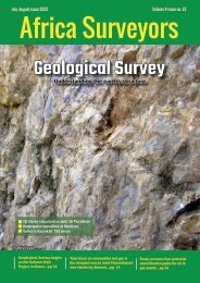
Sercel is pleased to announce that it<br />
now has a complete portfolio of seabed<br />
nodal solutions for all water depths<br />
down to 6,000 m to meet growing industry<br />
demand for ocean bottom node (OBN) seismic<br />
surveys. Based on Sercel’s unique QuietSeis®<br />
broadband digital sensor technology, the<br />
full OBN portfolio includes the GPR300, the<br />
GPR700, the GPR3000 and the MicrOBS.<br />
Image: Sercel<br />
Building on the success of the GPR300,<br />
the GPR700 was unveiled yesterday at the<br />
IMAGE <strong>2023</strong> convention in Houston. The<br />
GPR700 extends OBN survey operations to<br />
the limits of the continental shelf at depths<br />
of up to 700 meters. In response to growing<br />
requirements for deepwater exploration,<br />
Sercel is now also announcing a GPR3000<br />
nodal solution for high-density OBN surveys<br />
down to depths of 3,000 meters.<br />
To complete Sercel’s OBN offering, the<br />
MicrOBS sparse nodal solution is ideally<br />
suited for sparse deepwater OBN operations<br />
down to 6,000 meters.<br />
Emmanuelle Dubu, Sercel CEO, said: "We<br />
are delighted to now offer a full range of<br />
nodal solutions to the seismic industry. The<br />
common denominator and key differentiator<br />
of this portfolio is QuietSeis, the most<br />
accurate seismic sensor in the industry. Its<br />
extremely low-noise performance delivers<br />
high-fidelity, high-quality broadband datasets<br />
for high-precision subsurface imaging. With<br />
our comprehensive portfolio of high-tech<br />
OBN solutions — all seamlessly integrated<br />
into our new MetaBlue marine survey<br />
management solution — we are uniquely<br />
positioned to support our customers in their<br />
offshore exploration and monitoring projects,<br />
whatever the depth."<br />
New DJI Zenmuse L2 Increases Precision,<br />
Efficiency, And Reliability Of 3D Data Acquisition<br />
DJI, the world’s leader in civilian drones<br />
and creative camera technology,<br />
today introduces the DJI Zenmuse L2,<br />
a highly-integrated LiDAR system which<br />
builds on DJI’s successful Zenmuse L1. With<br />
an enhanced RGB camera, upgraded LiDAR<br />
module and improved accuracy, any enterprise<br />
professional with a DJI Matrice 300 RTK or DJI<br />
Matrice 350 RTK platform can benefit from<br />
more precise, efficient and reliable 3D data<br />
acquisition. Furthermore, when used with<br />
DJI Terra, it delivers a turnkey solution for<br />
3D data collection and high-accuracy postprocessing.<br />
“The DJI Zenmuse L2 marks a new era of<br />
3D data acquisition,” said Christina Zhang,<br />
Senior Director of Corporate Strategy at<br />
DJI. “Three years ago DJI was excited to<br />
introduce a reliable and cost-effective LiDAR<br />
system for aerial platforms used by land<br />
surveyors, electricity inspectors, and forestry<br />
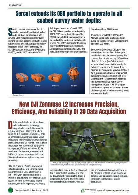
LiDAR, a self-developed IMU system, and a 4/3 CMOS RGB camera combine to give geospatial<br />
and inspection professionals greater insights. Image courtesy<br />
professionals, to name just a few. This aerial<br />
data is paramount in providing real-time<br />
3D data, efficiently capturing the details of<br />
complex structures and delivering highly<br />
accurate reconstructed models. With our<br />
aim of promoting industry development in<br />
all enterprise verticals, we are continuing<br />
to tackle user pain points through technical<br />
innovation and reshaping industry<br />
productivity.”<br />
10 <strong>September</strong>-<strong>October</strong> <strong>issue</strong> l <strong>2023</strong> www.africasurveyorsonline.com